Bridge Statistics for Warwick, Rhode Island (RI)
Condition, Traffic, Stress, Structural Evaluation, Project Costs
- National Bridge Inventory (NBI) Statistics
- 87Number of bridges
- 840ft / 256mTotal length
- $194,629,000Total costs
- 2,964,700Total average daily traffic
- 308,960Total average daily truck traffic
- National Bridge Inventory (NBI) Registered Bridges for Warwick
- No street view available for this location
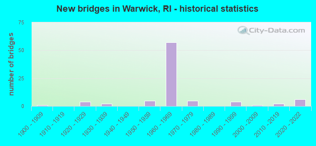
- New bridges - historical statistics
- 11900-1909
- 41920-1929
- 21930-1939
- 51950-1959
- 571960-1969
- 51970-1979
- 41990-1999
- 12000-2009
- 22010-2019
- 62020-2022

- Reconstructed bridges - Historical Statistics
- 11930-1939
- 01940-1949
- 01950-1959
- 01960-1969
- 11970-1979
- 101980-1989


- Bridge Condition - Deck
- 10.0%Very good
- 18.0%Good
- 48.0%Satisfactory
- 22.0%Fair
- 2.0%Poor

- Bridge Condition - Superstructure
- 9.1%Very good
- 9.1%Good
- 23.6%Satisfactory
- 41.8%Fair
- 7.3%Poor
- 9.1%Serious

- Bridge Condition - Substructure
- 3.6%Very good
- 14.5%Good
- 43.6%Satisfactory
- 29.1%Fair
- 9.1%Poor

- Bridge Condition - Channel
- 4.0%Very good
- 28.0%Good
- 52.0%Satisfactory
- 16.0%Fair

- Bridge Condition - Culverts
- 16.7%Good
- 83.3%Satisfactory
Find on map >> Show street view
Structure Number: 7222, Location: 0.5 Mi N of JCT I-95 (Lat: 41.723761, Lng: -71.480750), Route carried "under" structure: State highway 2, Year Built: 1967, Structure Length: 0. m, Average Daily Traffic: 20,650 (year 2008), Truck Traffic: 10%, Features Intersected: RI 2 BALD HILL RD
Minimum Vertical Clearance: 4.49m (14.73ft), Kilometerpoint: 0.000, Lanes on structure: 3, Lanes under structure: 6, Material/Design: Steel, Design/Construction: Stringer/Multi-beam, Length of Maximum Span: 33.2m (108.9ft)
Find on map >> Show street view
Structure Number: 77, Location: 0.5 Mi E of JCT I-95 (Lat: 41.726800, Lng: -71.454808), Route carried "under" structure: ServiceOther road , Year Built: 1967, Structure Length: 0. m, Average Daily Traffic: 8,105 (year 2021), Truck Traffic: 6%, Features Intersected: AIRPORT CONNECTOR, Facility Carried by Structure: METRO CENTER DRIVE
Minimum Vertical Clearance: 4.43m (14.53ft), Kilometerpoint: 0.000, Lanes on structure: 2, Lanes under structure: 4, Material/Design: Steel, Design/Construction: Stringer/Multi-beam, Length of Maximum Span: 25.9m (85.0ft)
Find on map >> Show street view
Structure Number: 771, Location: 0.8 Mi E of JCT I-95 (Lat: 41.723375, Lng: -71.444981), Route carried "under" structure: City street , Year Built: 1967, Structure Length: 0. m, Average Daily Traffic: 3,976 (year 2014), Truck Traffic: 10%, Features Intersected: JEFFERSON BLVD, Facility Carried by Structure: AIRPORT CONNECTOR
Minimum Vertical Clearance: 4.71m (15.45ft), Kilometerpoint: 0.000, Lanes on structure: 4, Lanes under structure: 4, Material/Design: Steel, Design/Construction: Stringer/Multi-beam, Length of Maximum Span: 25.6m (84.0ft)
Find on map >> Show street view
Structure Number: 773, Location: 0.4 Mi E of I-95 (Lat: 41.723092, Lng: -71.440736), Route carried "under" structure: US 1, Year Built: 1968, Structure Length: 0. m, Average Daily Traffic: 12,000 (year 2008), Truck Traffic: 10%, Features Intersected: US 1 POST RD, Facility Carried by Structure: AIRPORT CONNECTOR
Minimum Vertical Clearance: 4.09m (13.42ft), Kilometerpoint: 0.000, Lanes on structure: 4, Lanes under structure: 4, Material/Design: Steel, Design/Construction: Stringer/Multi-beam, Length of Maximum Span: 25.9m (85.0ft)
Find on map >> Show street view
Structure Number: 84, Location: 1.0 Mi E of JCT RI 5 (Lat: 41.711358, Lng: -71.447158), Route carried "under" structure: US 1, Year Built: 1976, Structure Length: 0. m, Average Daily Traffic: 40,100 (year 2008), Truck Traffic: 10%, Features Intersected: US 1 POST RD
Minimum Vertical Clearance: 5.11m (16.77ft), Kilometerpoint: 0.000, Lanes on structure: 5, Lanes under structure: 3, Material/Design: Steel, Design/Construction: Stringer/Multi-beam, Length of Maximum Span: 26.2m (86.0ft)