Bridge Statistics for Waco, Texas (TX)
Condition, Traffic, Stress, Structural Evaluation, Project Costs
- National Bridge Inventory (NBI) Statistics
- 323Number of bridges
- 6,362ft / 1,939mTotal length
- $289,830,000Total costs
- 5,682,723Total average daily traffic
- 514,108Total average daily truck traffic
- National Bridge Inventory (NBI) Registered Bridges for Waco
- No street view available for this location
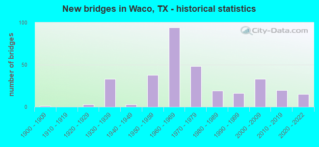
- New bridges - historical statistics
- 11900-1909
- 31920-1929
- 331930-1939
- 31940-1949
- 381950-1959
- 941960-1969
- 481970-1979
- 191980-1989
- 161990-1999
- 332000-2009
- 202010-2019
- 152020-2022

- Reconstructed bridges - Historical Statistics
- 21940-1949
- 111950-1959
- 111960-1969
- 71970-1979
- 121980-1989
- 51990-1999
- 32000-2009
- 32010-2019


- Bridge Condition - Deck
- 13.4%Excellent
- 51.9%Very good
- 19.3%Good
- 14.4%Satisfactory
- 1.1%Fair
- 0.5%Poor

- Bridge Condition - Superstructure
- 16.6%Very good
- 45.5%Good
- 30.5%Satisfactory
- 7.0%Fair
- 0.5%Poor

- Bridge Condition - Substructure
- 8.6%Very good
- 38.5%Good
- 38.0%Satisfactory
- 12.8%Fair
- 2.1%Poor

- Bridge Condition - Channel
- 5.8%Very good
- 33.3%Good
- 49.3%Satisfactory
- 9.7%Fair
- 1.9%Poor

- Bridge Condition - Culverts
- 56.2%Good
- 40.4%Satisfactory
- 3.4%Fair
Find on map >> Show street view
Structure Number: 91610196902009, Location: 1.6 MI NE OF SH 6 (Lat: 31.606606, Lng: -97.292358), Route carried "on" structure: State highway 185, Year Built: 1964, Status: Open, Structure Length: 85.19m (279.49ft), Average Daily Traffic: 10,271 (year 2020), Truck Traffic: 6%, Average Future Daily Traffic: 12,140 (year 2037), Design Load: H 20, Features Intersected: N BOSQUE RIVER
Minimum Vertical Clearance: 30+ m (98+ ft), Kilometerpoint: 2.128, Lanes on structure: 2, Base Highway Network: Yes, Owner: State Highway Agency, Approaching Roadway Width: 11.0m (36.1ft), Material/Design: Prestressed concrete, Design/Construction: Stringer/Multi-beam, Number Of Spans In Main Unit: 43, Length of Maximum Span: 19.8m (65.0ft), Curb-To-Curb Width: 8.5m (27.9ft), Out-to-Out Width: 10.1m (33.1ft)
Condition: Deck: Satisfactory, Superstructure: Good, Substructure: Satisfactory, Channel: Fair, Operating Rating: 68.0 metric tons, Method Used To Determine Operating Rating: Load Factor (LF), Inventory Rating: 30.8 metric tons, Method Used To Determine Inventory Rating: Load Factor (LF), Structural Evaluation: Equal to present minimum criteria, Deck Geometry: Meets minimum limits, Waterway Adequacy: Superior to present desirable criteria, Approach Roadway Alignment: Equal to present desirable criteria, Length Of Structure Improvement: 106.50m (349.41ft), Designated Inspection Frequency: Every 24 months, Underwater Inspection Frequency: Every 60 months, Inspection Date: March 2021, Underwater Inspection Date: April 2017, Bridge Improvement Cost: $10,200,000, Roadway Improvement Cost: $2,600,000, Total Project Cost: $16,000,000, Deck Structure Type: Concrete Cast-file-Place
Find on map >> Show street view
Structure Number: 91610231001002, Location: 5.4 Mi SE of SH 317 (Lat: 31.435556, Lng: -97.332281), Route carried "on" structure: State highway 2416, Year Built: 1958, Status: Open, Structure Length: 1.10m (3.61ft), Average Daily Traffic: 569 (year 2020), Truck Traffic: 11%, Average Future Daily Traffic: 780 (year 2037), Features Intersected: Willow Creek
Minimum Vertical Clearance: 30+ m (98+ ft), Kilometerpoint: 8.694, Lanes on structure: 2, Owner: State Highway Agency, Approaching Roadway Width: 6.7m (22.0ft), Skew: 3 degrees, Material/Design: Concrete, Design/Construction: Culvert, Number Of Spans In Main Unit: 4, Length of Maximum Span: 2.1m (6.9ft)
Condition: Channel: Good, Culverts: Satisfactory, Operating Rating: 39.9 metric tons, Method Used To Determine Operating Rating: Load Factor (LF), Inventory Rating: 23.6 metric tons, Method Used To Determine Inventory Rating: Load Factor (LF), Structural Evaluation: Equal to present minimum criteria, Waterway Adequacy: Better than present minimum criteria, Approach Roadway Alignment: Equal to present desirable criteria, Designated Inspection Frequency: Every 24 months, Inspection Date: December 2020
Find on map >> Show street view
Structure Number: 91610231001003, Location: 3.3 Mi NW of FM 2113 (Lat: 31.436736, Lng: -97.324544), Route carried "on" structure: State highway 2416, Year Built: 1958, Status: Open, Structure Length: 0.94m (3.08ft), Average Daily Traffic: 968 (year 2020), Truck Traffic: 9%, Average Future Daily Traffic: 1,110 (year 2037), Features Intersected: Willow Creek
Minimum Vertical Clearance: 30+ m (98+ ft), Kilometerpoint: 9.658, Lanes on structure: 2, Owner: State Highway Agency, Approaching Roadway Width: 6.7m (22.0ft), Skew: 3 degrees, Material/Design: Concrete, Design/Construction: Culvert, Number Of Spans In Main Unit: 3, Length of Maximum Span: 2.4m (7.9ft)
Condition: Channel: Satisfactory, Culverts: Satisfactory, Operating Rating: 39.9 metric tons, Method Used To Determine Operating Rating: Load Factor (LF), Inventory Rating: 23.6 metric tons, Method Used To Determine Inventory Rating: Load Factor (LF), Structural Evaluation: Equal to present minimum criteria, Waterway Adequacy: Better than present minimum criteria, Approach Roadway Alignment: Equal to present desirable criteria, Designated Inspection Frequency: Every 24 months, Inspection Date: December 2020
Find on map >> Show street view
Structure Number: 91610231001004, Location: 2.2 Mi NW of FM 2113 (Lat: 31.421742, Lng: -97.314208), Route carried "on" structure: State highway 2416, Year Built: 1958, Status: Open, Structure Length: 6.10m (20.01ft), Average Daily Traffic: 968 (year 2020), Truck Traffic: 9%, Average Future Daily Traffic: 1,110 (year 2037), Design Load: H 15, Features Intersected: S Bosque River
Minimum Vertical Clearance: 30+ m (98+ ft), Kilometerpoint: 11.528, Lanes on structure: 2, Owner: State Highway Agency, Approaching Roadway Width: 7.0m (23.0ft), Material/Design: Concrete, Design/Construction: Stringer/Multi-beam, Number Of Spans In Main Unit: 5, Length of Maximum Span: 12.2m (40.0ft), Curb-To-Curb Width: 7.3m (24.0ft), Out-to-Out Width: 7.8m (25.6ft)
Condition: Deck: Satisfactory, Superstructure: Satisfactory, Substructure: Satisfactory, Channel: Fair, Operating Rating: 39.0 metric tons, Method Used To Determine Operating Rating: Load Factor (LF), Inventory Rating: 23.6 metric tons, Method Used To Determine Inventory Rating: Load Factor (LF), Structural Evaluation: Equal to present minimum criteria, Deck Geometry: Meets minimum limits, Waterway Adequacy: Equal to present desirable criteria, Approach Roadway Alignment: Equal to present desirable criteria, Length Of Structure Improvement: 7.32m (24.02ft), Designated Inspection Frequency: Every 24 months, Inspection Date: December 2020, Bridge Improvement Cost: $846,000, Roadway Improvement Cost: $211,000, Total Project Cost: $1,057,000, Deck Structure Type: Concrete Cast-file-Place, Wearing Surface/Protective System: Wearing Surface: Bituminous
Find on map >> Show street view
Structure Number: 91610231101001, Location: 3.0 MI NW INT FM 933 (Lat: 31.599875, Lng: -97.157817), Route carried "on" structure: State highway 3051, Year Built: 1969, Status: Open, Structure Length: 1.13m (3.71ft), Average Daily Traffic: 18,098 (year 2020), Truck Traffic: 1%, Average Future Daily Traffic: 13,000 (year 2033), Design Load: HS 20, Features Intersected: TRIB OF BRAZOS RIVER
Minimum Vertical Clearance: 30+ m (98+ ft), Kilometerpoint: 6.075, Lanes on structure: 4, Owner: State Highway Agency, Approaching Roadway Width: 16.5m (54.1ft), Skew: 4 degrees, Material/Design: Concrete, Design/Construction: Culvert, Number Of Spans In Main Unit: 3, Length of Maximum Span: 3.4m (11.2ft)
Condition: Channel: Good, Culverts: Good, Operating Rating: 39.9 metric tons, Method Used To Determine Operating Rating: Load Factor (LF), Inventory Rating: 23.6 metric tons, Method Used To Determine Inventory Rating: Load Factor (LF), Structural Evaluation: Somewhat better than minimum adequacy, Waterway Adequacy: Equal to present minimum criteria, Approach Roadway Alignment: Equal to present desirable criteria, Designated Inspection Frequency: Every 24 months, Inspection Date: April 2021
Find on map >> Show street view
Structure Number: 91610231101002, Location: 1.4 MI W OF FM 933 (Lat: 31.608592, Lng: -97.130572), Route carried "on" structure: State highway 3051, Year Built: 1969, Status: Open, Structure Length: 12.95m (42.49ft), Average Daily Traffic: 9,914 (year 2020), Truck Traffic: 3%, Average Future Daily Traffic: 15,000 (year 2037), Design Load: H 20, Features Intersected: BRAZOS RIVER
Minimum Vertical Clearance: 30+ m (98+ ft), Kilometerpoint: 8.966, Lanes on structure: 2, Base Highway Network: Yes, Owner: State Highway Agency, Approaching Roadway Width: 13.4m (44.0ft), Material/Design: Prestressed concrete, Design/Construction: Stringer/Multi-beam, Number Of Spans In Main Unit: 5, Length of Maximum Span: 25.9m (85.0ft), Curb-To-Curb Width: 13.4m (44.0ft), Out-to-Out Width: 13.9m (45.6ft)
Condition: Deck: Very good, Superstructure: Good, Substructure: Satisfactory, Channel: Satisfactory, Operating Rating: 58.0 metric tons, Method Used To Determine Operating Rating: Load Factor (LF), Inventory Rating: 19.0 metric tons, Method Used To Determine Inventory Rating: Load Factor (LF), Structural Evaluation: Meets minimum limits, Deck Geometry: Superior to present desirable criteria, Waterway Adequacy: Superior to present desirable criteria, Approach Roadway Alignment: Equal to present desirable criteria, Designated Inspection Frequency: Every 24 months, Underwater Inspection Frequency: Every 60 months, Inspection Date: April 2021, Underwater Inspection Date: November 2020, Deck Structure Type: Concrete Cast-file-Place, Wearing Surface/Protective System: Wearing Surface: Bituminous
Find on map >> Show street view
Structure Number: 91610231101007, Location: 1.4 MI W OF FM 933 (Lat: 31.608897, Lng: -97.130531), Route carried "on" structure: State highway 3051, Year Built: 1988, Status: Open, Structure Length: 12.95m (42.49ft), Average Daily Traffic: 9,907 (year 2020), Truck Traffic: 3%, Average Future Daily Traffic: 15,000 (year 2037), Design Load: HS 20, Features Intersected: BRAZOS RIVER
Minimum Vertical Clearance: 30+ m (98+ ft), Kilometerpoint: 8.966, Lanes on structure: 2, Base Highway Network: Yes, Owner: State Highway Agency, Approaching Roadway Width: 11.6m (38.1ft), Material/Design: Prestressed concrete, Design/Construction: Stringer/Multi-beam, Number Of Spans In Main Unit: 5, Length of Maximum Span: 25.9m (85.0ft), Curb-To-Curb Width: 11.3m (37.1ft), Out-to-Out Width: 12.2m (40.0ft)
Condition: Deck: Very good, Superstructure: Very good, Substructure: Satisfactory, Channel: Satisfactory, Operating Rating: 54.4 metric tons, Method Used To Determine Operating Rating: Assigned rating based on Load Factor Design (LFD) reported in metric tons, Inventory Rating: 32.7 metric tons, Method Used To Determine Inventory Rating: Assigned rating based on Load Factor Design (LFD) reported in metric tons, Structural Evaluation: Equal to present minimum criteria, Deck Geometry: Equal to present minimum criteria, Waterway Adequacy: Superior to present desirable criteria, Approach Roadway Alignment: Equal to present desirable criteria, Designated Inspection Frequency: Every 24 months, Underwater Inspection Frequency: Every 60 months, Inspection Date: April 2021, Underwater Inspection Date: November 2020, Deck Structure Type: Concrete Cast-file-Place, Wearing Surface/Protective System: Wearing Surface: Bituminous
Find on map >> Show street view
Structure Number: 91610236201001, Location: 1.00 Mi N of SH 6 (Lat: 31.561525, Lng: -97.067714), Route carried "on" structure: State highway 340, Year Built: 1965, Status: Open, Structure Length: 0.94m (3.08ft), Average Daily Traffic: 15,984 (year 2020), Truck Traffic: 11%, Average Future Daily Traffic: 19,180 (year 2030), Design Load: HS 20, Features Intersected: Trib Brazos River
Minimum Vertical Clearance: 30+ m (98+ ft), Kilometerpoint: 4.764, Lanes on structure: 2, Base Highway Network: Yes, Owner: State Highway Agency, Approaching Roadway Width: 13.4m (44.0ft), Material/Design: Concrete, Design/Construction: Culvert, Number Of Spans In Main Unit: 4, Length of Maximum Span: 2.1m (6.9ft)
Condition: Channel: Very good, Culverts: Good, Operating Rating: 39.9 metric tons, Method Used To Determine Operating Rating: Load Factor (LF), Inventory Rating: 23.6 metric tons, Method Used To Determine Inventory Rating: Load Factor (LF), Structural Evaluation: Somewhat better than minimum adequacy, Waterway Adequacy: Equal to present minimum criteria, Approach Roadway Alignment: Equal to present desirable criteria, Designated Inspection Frequency: Every 24 months, Inspection Date: December 2020
Find on map >> Show street view
Structure Number: 91610239501001, Location: 1.2 MI E OF LP 340 (Lat: 31.564119, Lng: -97.048733), Route carried "on" structure: State highway 2491, Year Built: 1960, Status: Open, Structure Length: 7.35m (24.11ft), Average Daily Traffic: 1,104 (year 2018), Truck Traffic: 18%, Average Future Daily Traffic: 1,770 (year 2037), Features Intersected: TEHUACANA CREEK
Minimum Vertical Clearance: 30+ m (98+ ft), Kilometerpoint: 1.944, Lanes on structure: 2, Owner: State Highway Agency, Approaching Roadway Width: 7.9m (25.9ft), Material/Design: Concrete, Design/Construction: Stringer/Multi-beam, Number Of Spans In Main Unit: 7, Length of Maximum Span: 12.2m (40.0ft), Curb-To-Curb Width: 7.3m (24.0ft), Out-to-Out Width: 7.8m (25.6ft)
Condition: Deck: Good, Superstructure: Good, Substructure: Fair, Channel: Fair, Operating Rating: 41.7 metric tons, Method Used To Determine Operating Rating: Load Factor (LF), Inventory Rating: 24.5 metric tons, Method Used To Determine Inventory Rating: Load Factor (LF), Structural Evaluation: Somewhat better than minimum adequacy, Deck Geometry: Meets minimum limits, Waterway Adequacy: Somewhat better than minimum adequacy, Approach Roadway Alignment: Equal to present desirable criteria, Length Of Structure Improvement: 8.53m (27.99ft), Designated Inspection Frequency: Every 24 months, Inspection Date: March 2021, Bridge Improvement Cost: $762,000, Roadway Improvement Cost: $190,000, Total Project Cost: $952,000, Deck Structure Type: Concrete Cast-file-Place, Wearing Surface/Protective System: Wearing Surface: Bituminous
Find on map >> Show street view
Structure Number: 91610239501002, Location: 1.7 MI E OF LP 340 (Lat: 31.565125, Lng: -97.040483), Route carried "on" structure: State highway 2491, Year Built: 1960, Status: Open, Structure Length: 2.77m (9.09ft), Average Daily Traffic: 1,104 (year 2018), Truck Traffic: 17%, Average Future Daily Traffic: 1,770 (year 2037), Features Intersected: WILLIAMS CREEK
Minimum Vertical Clearance: 30+ m (98+ ft), Kilometerpoint: 2.736, Lanes on structure: 2, Owner: State Highway Agency, Approaching Roadway Width: 7.9m (25.9ft), Material/Design: Concrete, Design/Construction: Stringer/Multi-beam, Number Of Spans In Main Unit: 3, Length of Maximum Span: 9.1m (29.9ft), Curb-To-Curb Width: 7.3m (24.0ft), Out-to-Out Width: 7.8m (25.6ft)
Condition: Deck: Good, Superstructure: Good, Substructure: Satisfactory, Channel: Satisfactory, Operating Rating: 51.7 metric tons, Method Used To Determine Operating Rating: Load Factor (LF), Inventory Rating: 30.8 metric tons, Method Used To Determine Inventory Rating: Load Factor (LF), Structural Evaluation: Equal to present minimum criteria, Deck Geometry: Meets minimum limits, Waterway Adequacy: Somewhat better than minimum adequacy, Approach Roadway Alignment: Equal to present desirable criteria, Length Of Structure Improvement: 4.27m (14.01ft), Designated Inspection Frequency: Every 24 months, Inspection Date: March 2021, Bridge Improvement Cost: $381,000, Roadway Improvement Cost: $95,000, Total Project Cost: $476,000, Deck Structure Type: Concrete Cast-file-Place, Wearing Surface/Protective System: Wearing Surface: Bituminous
Find on map >> Show street view
Structure Number: 91610239501003, Location: 2.0 MI E OF LP 340 (Lat: 31.564269, Lng: -97.035478), Route carried "on" structure: State highway 2491, Year Built: 1960, Status: Open, Structure Length: 0.67m (2.20ft), Average Daily Traffic: 1,104 (year 2018), Truck Traffic: 17%, Average Future Daily Traffic: 1,770 (year 2037), Design Load: H 20, Features Intersected: TRIB TEHUACANA CREEK
Minimum Vertical Clearance: 30+ m (98+ ft), Kilometerpoint: 3.244, Lanes on structure: 2, Owner: State Highway Agency, Approaching Roadway Width: 7.9m (25.9ft), Material/Design: Concrete, Design/Construction: Culvert, Number Of Spans In Main Unit: 3, Length of Maximum Span: 2.1m (6.9ft), Curb-To-Curb Width: 7.9m (25.9ft), Out-to-Out Width: 12.6m (41.3ft)
Condition: Channel: Satisfactory, Culverts: Satisfactory, Operating Rating: 39.9 metric tons, Method Used To Determine Operating Rating: Load Factor (LF), Inventory Rating: 23.6 metric tons, Method Used To Determine Inventory Rating: Load Factor (LF), Structural Evaluation: Equal to present minimum criteria, Deck Geometry: Meets minimum limits, Waterway Adequacy: Equal to present minimum criteria, Approach Roadway Alignment: Equal to present desirable criteria, Designated Inspection Frequency: Every 24 months, Inspection Date: March 2021, Deck Structure Type: Concrete Cast-file-Place, Wearing Surface/Protective System: Wearing Surface: Bituminous
Find on map >> Show street view
Structure Number: 91610239602003, Location: 2.0 Mi NW of FM 1637 (Lat: 31.655978, Lng: -97.260064), Route carried "on" structure: State highway 2490, Year Built: 1959, Year Reconstructed: 1997, Status: Open, Structure Length: 0.70m (2.30ft), Average Daily Traffic: 4,856 (year 2020), Truck Traffic: 11%, Average Future Daily Traffic: 6,630 (year 2033), Features Intersected: Rock Creek
Minimum Vertical Clearance: 30+ m (98+ ft), Kilometerpoint: 9.897, Lanes on structure: 2, Owner: State Highway Agency, Approaching Roadway Width: 12.8m (42.0ft), Material/Design: Concrete, Design/Construction: Culvert, Number Of Spans In Main Unit: 3, Length of Maximum Span: 2.1m (6.9ft), Curb-To-Curb Width: 12.3m (40.4ft), Out-to-Out Width: 16.9m (55.4ft)
Condition: Channel: Fair, Culverts: Satisfactory, Operating Rating: 39.9 metric tons, Method Used To Determine Operating Rating: Load Factor (LF), Inventory Rating: 23.6 metric tons, Method Used To Determine Inventory Rating: Load Factor (LF), Structural Evaluation: Equal to present minimum criteria, Deck Geometry: Equal to present minimum criteria, Waterway Adequacy: Equal to present minimum criteria, Approach Roadway Alignment: Equal to present desirable criteria, Designated Inspection Frequency: Every 24 months, Inspection Date: December 2020, Deck Structure Type: Concrete Cast-file-Place, Wearing Surface/Protective System: Wearing Surface: Bituminous
Find on map >> Show street view
Structure Number: 91610250601002, Location: 1.1 Mi SE of US 84 (Lat: 31.484733, Lng: -97.209736), Route carried "on" structure: State highway 1695, Year Built: 1961, Year Reconstructed: 1984, Status: Open, Structure Length: 0.76m (2.49ft), Average Daily Traffic: 30,479 (year 2020), Truck Traffic: 22%, Average Future Daily Traffic: 26,050 (year 2033), Features Intersected: Flat Creek
Minimum Vertical Clearance: 30+ m (98+ ft), Kilometerpoint: 33.912, Lanes on structure: 5, Base Highway Network: Yes, Owner: State Highway Agency, Approaching Roadway Width: 25.0m (82.0ft), Skew: 4 degrees, Material/Design: Concrete, Design/Construction: Culvert, Number Of Spans In Main Unit: 2, Length of Maximum Span: 2.4m (7.9ft)
Condition: Channel: Good, Culverts: Satisfactory, Operating Rating: 39.9 metric tons, Method Used To Determine Operating Rating: Load Factor (LF), Inventory Rating: 23.6 metric tons, Method Used To Determine Inventory Rating: Load Factor (LF), Structural Evaluation: Somewhat better than minimum adequacy, Waterway Adequacy: Equal to present minimum criteria, Approach Roadway Alignment: Equal to present desirable criteria, Designated Inspection Frequency: Every 24 months, Inspection Date: January 2021
Find on map >> Show street view
Structure Number: 91610312901002, Location: 5.3 Mi NE of SH 317 (Lat: 31.510750, Lng: -97.364350), Route carried "on" structure: State highway 3047, Year Built: 1976, Status: Open, Structure Length: 0.94m (3.08ft), Average Daily Traffic: 906 (year 2020), Truck Traffic: 22%, Average Future Daily Traffic: 1,150 (year 2037), Design Load: HS 20, Features Intersected: Trib Middle Bosque River
Minimum Vertical Clearance: 30+ m (98+ ft), Kilometerpoint: 8.518, Lanes on structure: 2, Owner: State Highway Agency, Approaching Roadway Width: 7.3m (24.0ft), Material/Design: Concrete, Design/Construction: Culvert, Number Of Spans In Main Unit: 4, Length of Maximum Span: 2.1m (6.9ft), Curb-To-Curb Width: 9.7m (31.8ft), Out-to-Out Width: 14.6m (47.9ft)
Condition: Channel: Good, Culverts: Good, Operating Rating: 39.9 metric tons, Method Used To Determine Operating Rating: Load Factor (LF), Inventory Rating: 23.6 metric tons, Method Used To Determine Inventory Rating: Load Factor (LF), Structural Evaluation: Equal to present minimum criteria, Deck Geometry: Equal to present minimum criteria, Waterway Adequacy: Equal to present minimum criteria, Approach Roadway Alignment: Better than present minimum criteria, Length Of Structure Improvement: 1.83m (6.00ft), Designated Inspection Frequency: Every 24 months, Inspection Date: Febuary 2021, Bridge Improvement Cost: $200,000, Roadway Improvement Cost: $100,000, Total Project Cost: $400,000, Deck Structure Type: Concrete Cast-file-Place, Wearing Surface/Protective System: Wearing Surface: Bituminous
Find on map >> Show street view
Structure Number: 91610312901003, Location: 6.3 Mi NE of SH 317 (Lat: 31.517669, Lng: -97.349114), Route carried "on" structure: State highway 3047, Year Built: 1976, Status: Open, Structure Length: 1.01m (3.31ft), Average Daily Traffic: 906 (year 2020), Truck Traffic: 6%, Average Future Daily Traffic: 760 (year 2033), Design Load: HS 20, Features Intersected: Trib Middle Bosque River
Minimum Vertical Clearance: 30+ m (98+ ft), Kilometerpoint: 10.165, Lanes on structure: 2, Owner: State Highway Agency, Approaching Roadway Width: 6.7m (22.0ft), Skew: 4 degrees, Material/Design: Concrete, Design/Construction: Culvert, Number Of Spans In Main Unit: 3, Length of Maximum Span: 2.1m (6.9ft), Curb-To-Curb Width: 11.0m (36.1ft), Out-to-Out Width: 11.4m (37.4ft)
Condition: Channel: Good, Culverts: Good, Operating Rating: 39.9 metric tons, Method Used To Determine Operating Rating: Load Factor (LF), Inventory Rating: 23.6 metric tons, Method Used To Determine Inventory Rating: Load Factor (LF), Structural Evaluation: Equal to present minimum criteria, Deck Geometry: Better than present minimum criteria, Waterway Adequacy: Better than present minimum criteria, Approach Roadway Alignment: Equal to present desirable criteria, Length Of Structure Improvement: 1.83m (6.00ft), Designated Inspection Frequency: Every 48 months, Inspection Date: Febuary 2021, Bridge Improvement Cost: $200,000, Roadway Improvement Cost: $100,000, Total Project Cost: $400,000, Deck Structure Type: Concrete Cast-file-Place, Wearing Surface/Protective System: Wearing Surface: Bituminous
Find on map >> Show street view
Structure Number: 91610333001001, Location: 0.5 MI SW INT SH 6 (Lat: 31.502494, Lng: -97.187950), Route carried "on" structure: State highway 3223, Year Built: 1973, Status: Open, Structure Length: 1.31m (4.30ft), Average Daily Traffic: 18,883 (year 2020), Truck Traffic: 1%, Average Future Daily Traffic: 24,630 (year 2033), Design Load: HS 20, Features Intersected: NORTH FLAT CREEK
Minimum Vertical Clearance: 30+ m (98+ ft), Kilometerpoint: 10.845, Lanes on structure: 5, Owner: State Highway Agency, Approaching Roadway Width: 22.6m (74.1ft), Material/Design: Concrete, Design/Construction: Culvert, Number Of Spans In Main Unit: 4, Length of Maximum Span: 3.0m (9.8ft)
Condition: Channel: Satisfactory, Culverts: Good, Operating Rating: 39.9 metric tons, Method Used To Determine Operating Rating: Load Factor (LF), Inventory Rating: 23.6 metric tons, Method Used To Determine Inventory Rating: Load Factor (LF), Structural Evaluation: Somewhat better than minimum adequacy, Waterway Adequacy: Equal to present minimum criteria, Approach Roadway Alignment: Equal to present desirable criteria, Length Of Structure Improvement: 1.83m (6.00ft), Designated Inspection Frequency: Every 24 months, Inspection Date: April 2021, Bridge Improvement Cost: $200,000, Roadway Improvement Cost: $100,000, Total Project Cost: $400,000
Find on map >> Show street view
Structure Number: 91610352101003, Location: 0.9 MI S OF US 84 (Lat: 31.474094, Lng: -97.275119), Route carried "on" structure: State highway 2837, Year Built: 2004, Status: Open, Structure Length: 24.81m (81.40ft), Average Daily Traffic: 4,534 (year 2017), Truck Traffic: 17%, Average Future Daily Traffic: 6,350 (year 2037), Design Load: HS 20, Features Intersected: S BOSQUE RIVER
Minimum Vertical Clearance: 30+ m (98+ ft), Kilometerpoint: 3.475, Lanes on structure: 2, Owner: State Highway Agency, Approaching Roadway Width: 11.9m (39.0ft), Material/Design: Prestressed concrete, Design/Construction: Stringer/Multi-beam, Number Of Spans In Main Unit: 8, Length of Maximum Span: 31.1m (102.0ft), Curb-To-Curb Width: 12.0m (39.4ft), Out-to-Out Width: 12.6m (41.3ft)
Condition: Deck: Good, Superstructure: Very good, Substructure: Good, Channel: Satisfactory, Operating Rating: 54.4 metric tons, Method Used To Determine Operating Rating: Assigned rating based on Load Factor Design (LFD) reported in metric tons, Inventory Rating: 32.7 metric tons, Method Used To Determine Inventory Rating: Assigned rating based on Load Factor Design (LFD) reported in metric tons, Structural Evaluation: Better than present minimum criteria, Deck Geometry: Somewhat better than minimum adequacy, Waterway Adequacy: Superior to present desirable criteria, Approach Roadway Alignment: Better than present minimum criteria, Designated Inspection Frequency: Every 24 months, Inspection Date: April 2021, Deck Structure Type: Concrete Precast Panels
Find on map >> Show street view
Structure Number: 91610AA0120001, Location: 0.70 MI S OF US 84 (Lat: 31.431303, Lng: -97.463933), Route carried "on" structure: County highway 449, Year Built: 1974, Status: Open, Structure Length: 0.67m (2.20ft), Average Daily Traffic: 60 (year 2016), Average Future Daily Traffic: 60 (year 2036), Features Intersected: BR HARRIS CRK #345, Facility Carried by Structure: OLD OGLESBY RD
Minimum Vertical Clearance: 30+ m (98+ ft), Kilometerpoint: 2.414, Lanes on structure: 2, Owner: County Highway Agency, Approaching Roadway Width: 5.5m (18.0ft), Material/Design: Concrete, Design/Construction: Culvert, Number Of Spans In Main Unit: 2, Length of Maximum Span: 3.0m (9.8ft), Curb-To-Curb Width: 7.3m (24.0ft), Out-to-Out Width: 7.7m (25.3ft)
Condition: Channel: Good, Culverts: Good, Operating Rating: 39.9 metric tons, Method Used To Determine Operating Rating: Load Factor (LF), Inventory Rating: 23.6 metric tons, Method Used To Determine Inventory Rating: Load Factor (LF), Structural Evaluation: Equal to present minimum criteria, Deck Geometry: Equal to present minimum criteria, Waterway Adequacy: Meets minimum limits, Approach Roadway Alignment: Equal to present desirable criteria, Length Of Structure Improvement: 1.83m (6.00ft), Designated Inspection Frequency: Every 24 months, Inspection Date: March 2020, Bridge Improvement Cost: $167,000, Roadway Improvement Cost: $41,000, Total Project Cost: $208,000, Deck Structure Type: Concrete Cast-file-Place
Find on map >> Show street view
Structure Number: 91610AA0186001, Location: 0.60 MI S OF FM 185 (Lat: 31.575744, Lng: -97.304892), Route carried "on" structure: County highway 420, Year Built: 1988, Status: Open, Structure Length: 1.55m (5.09ft), Average Daily Traffic: 160 (year 2020), Average Future Daily Traffic: 330 (year 2036), Features Intersected: TENNANT BR TRIB #415, Facility Carried by Structure: SPEEGLE RD
Minimum Vertical Clearance: 30+ m (98+ ft), Kilometerpoint: 0.966, Lanes on structure: 2, Owner: County Highway Agency, Approaching Roadway Width: 5.5m (18.0ft), Material/Design: Prestressed concrete, Number Of Spans In Main Unit: 1, Length of Maximum Span: 14.9m (48.9ft), Curb-To-Curb Width: 6.9m (22.6ft), Out-to-Out Width: 7.1m (23.3ft)
Condition: Deck: Good, Superstructure: Good, Substructure: Satisfactory, Channel: Satisfactory, Operating Rating: 32.7 metric tons, Method Used To Determine Operating Rating: Field evaluation and documented engineering judgment, Inventory Rating: 24.5 metric tons, Method Used To Determine Inventory Rating: Field evaluation and documented engineering judgment, Structural Evaluation: Equal to present minimum criteria, Deck Geometry: Meets minimum limits, Waterway Adequacy: Equal to present minimum criteria, Approach Roadway Alignment: Equal to present desirable criteria, Length Of Structure Improvement: 2.74m (8.99ft), Designated Inspection Frequency: Every 24 months, Inspection Date: Febuary 2020, Bridge Improvement Cost: $251,000, Roadway Improvement Cost: $62,000, Total Project Cost: $313,000, Deck Structure Type: Concrete Precast Panels, Wearing Surface/Protective System: Wearing Surface: Bituminous
Find on map >> Show street view
Structure Number: 91610AA0186002, Location: 2.65 MI SE OF FM 185 (Lat: 31.554636, Lng: -97.284050), Route carried "on" structure: County highway 420, Year Built: 1970, Status: Open, Structure Length: 0.91m (2.99ft), Average Daily Traffic: 1,089 (year 2020), Average Future Daily Traffic: 1,500 (year 2036), Features Intersected: SPEEGLEVILLE CRK #413, Facility Carried by Structure: SPEEGLE RD
Minimum Vertical Clearance: 30+ m (98+ ft), Kilometerpoint: 4.265, Lanes on structure: 2, Owner: County Highway Agency, Approaching Roadway Width: 6.1m (20.0ft), Material/Design: Prestressed concrete, Number Of Spans In Main Unit: 1, Length of Maximum Span: 8.8m (28.9ft), Curb-To-Curb Width: 7.0m (23.0ft), Out-to-Out Width: 7.4m (24.3ft)
Condition: Deck: Satisfactory, Superstructure: Good, Substructure: Satisfactory, Channel: Satisfactory, Operating Rating: 39.9 metric tons, Method Used To Determine Operating Rating: Allowable Stress (AS), Inventory Rating: 23.6 metric tons, Method Used To Determine Inventory Rating: Allowable Stress (AS), Structural Evaluation: Equal to present minimum criteria, Deck Geometry: High priority of corrective action, Waterway Adequacy: Meets minimum limits, Approach Roadway Alignment: Equal to present desirable criteria, Length Of Structure Improvement: 1.83m (6.00ft), Designated Inspection Frequency: Every 24 months, Inspection Date: Febuary 2020, Bridge Improvement Cost: $167,000, Roadway Improvement Cost: $41,000, Total Project Cost: $208,000, Deck Structure Type: Concrete Precast Panels, Wearing Surface/Protective System: Wearing Surface: Bituminous
Find on map >> Show street view
Structure Number: 91610AA0186003, Location: 2.70 MI SE OF FM 185 (Lat: 31.553900, Lng: -97.283500), Route carried "on" structure: County highway 420, Year Built: 1970, Status: Open, Structure Length: 0.91m (2.99ft), Average Daily Traffic: 1,089 (year 2020), Average Future Daily Traffic: 1,500 (year 2036), Features Intersected: BR SPEEGLEVILLE CRK #416, Facility Carried by Structure: SPEEGLE RD
Minimum Vertical Clearance: 30+ m (98+ ft), Kilometerpoint: 4.345, Lanes on structure: 2, Owner: County Highway Agency, Approaching Roadway Width: 6.1m (20.0ft), Material/Design: Prestressed concrete, Number Of Spans In Main Unit: 1, Length of Maximum Span: 8.8m (28.9ft), Curb-To-Curb Width: 7.0m (23.0ft), Out-to-Out Width: 7.4m (24.3ft)
Condition: Deck: Good, Superstructure: Good, Substructure: Satisfactory, Channel: Satisfactory, Operating Rating: 39.0 metric tons, Method Used To Determine Operating Rating: Allowable Stress (AS), Inventory Rating: 23.6 metric tons, Method Used To Determine Inventory Rating: Allowable Stress (AS), Structural Evaluation: Equal to present minimum criteria, Deck Geometry: High priority of corrective action, Waterway Adequacy: Meets minimum limits, Approach Roadway Alignment: Equal to present desirable criteria, Length Of Structure Improvement: 1.83m (6.00ft), Designated Inspection Frequency: Every 24 months, Inspection Date: Febuary 2020, Bridge Improvement Cost: $167,000, Roadway Improvement Cost: $41,000, Total Project Cost: $208,000, Deck Structure Type: Concrete Precast Panels, Wearing Surface/Protective System: Wearing Surface: Bituminous
Find on map >> Show street view
Structure Number: 91610AA0188001, Location: 0.15 MI NW OF RANDY DR (Lat: 31.551372, Lng: -97.297611), Route carried "on" structure: County highway , Year Built: 1988, Status: Open, Structure Length: 0.85m (2.79ft), Average Daily Traffic: 490 (year 2020), Average Future Daily Traffic: 400 (year 2036), Features Intersected: SPEEGLEVIL CRK TRIB #463, Facility Carried by Structure: WILLOW GROVE RD
Minimum Vertical Clearance: 30+ m (98+ ft), Kilometerpoint: 1.690, Lanes on structure: 2, Owner: County Highway Agency, Approaching Roadway Width: 6.1m (20.0ft), Material/Design: Aluminum, Iron, Number Of Spans In Main Unit: 1, Length of Maximum Span: 8.2m (26.9ft), Curb-To-Curb Width: 7.7m (25.3ft), Out-to-Out Width: 7.9m (25.9ft)
Condition: Deck: Satisfactory, Superstructure: Satisfactory, Substructure: Satisfactory, Channel: Satisfactory, Operating Rating: 38.1 metric tons, Method Used To Determine Operating Rating: Allowable Stress (AS), Inventory Rating: 26.3 metric tons, Method Used To Determine Inventory Rating: Allowable Stress (AS), Structural Evaluation: Equal to present minimum criteria, Deck Geometry: Meets minimum limits, Waterway Adequacy: Better than present minimum criteria, Approach Roadway Alignment: Equal to present desirable criteria, Length Of Structure Improvement: 1.83m (6.00ft), Designated Inspection Frequency: Every 24 months, Inspection Date: March 2020, Bridge Improvement Cost: $167,000, Roadway Improvement Cost: $41,000, Total Project Cost: $208,000, Deck Structure Type: Aluminum
Find on map >> Show street view
Structure Number: 91610AA0195001, Location: 3.70 MI SW OF SH 6 (Lat: 31.529222, Lng: -97.299119), Route carried "on" structure: County highway , Year Built: 1950, Status: Posted for load, Structure Length: 0.85m (2.79ft), Average Daily Traffic: 65 (year 2016), Average Future Daily Traffic: 60 (year 2036), Features Intersected: BR HOG CRK #913, Facility Carried by Structure: MARIE DR
Minimum Vertical Clearance: 30+ m (98+ ft), Kilometerpoint: 1.448, Lanes on structure: 1, Owner: County Highway Agency, Approaching Roadway Width: 4.3m (14.1ft), Material/Design: Wood or Timber, Design/Construction: Stringer/Multi-beam, Number Of Spans In Main Unit: 2, Length of Maximum Span: 4.3m (14.1ft), Curb-To-Curb Width: 5.8m (19.0ft), Out-to-Out Width: 6.1m (20.0ft)
Condition: Deck: Satisfactory, Superstructure: Satisfactory, Substructure: Fair, Channel: Satisfactory, Operating Rating: 20.9 metric tons, Method Used To Determine Operating Rating: Allowable Stress (AS), Inventory Rating: 13.6 metric tons, Method Used To Determine Inventory Rating: Allowable Stress (AS), Structural Evaluation: Meets minimum limits, Deck Geometry: Meets minimum limits, Waterway Adequacy: Meets minimum limits, Approach Roadway Alignment: Equal to present desirable criteria, Bridge Posting: Required (Relationship of Operating Rating to Maximum Legal Load: 30.0 - 39.9% below), Length Of Structure Improvement: 1.83m (6.00ft), Designated Inspection Frequency: Every 24 months, Inspection Date: March 2020, Bridge Improvement Cost: $167,000, Roadway Improvement Cost: $41,000, Total Project Cost: $208,000, Deck Structure Type: Wood or Timber, Wearing Surface/Protective System: Wearing Surface: Bituminous
Find on map >> Show street view
Structure Number: 91610AA0330001, Location: 0.85 MI NE OF FM 2188 (Lat: 31.447517, Lng: -97.318528), Route carried "on" structure: County highway 457, Year Built: 1974, Status: Open, Structure Length: 0.79m (2.59ft), Average Daily Traffic: 157 (year 2020), Average Future Daily Traffic: 95 (year 2036), Features Intersected: BAYLOR CRK #91, Facility Carried by Structure: CHURCH RD
Minimum Vertical Clearance: 30+ m (98+ ft), Kilometerpoint: 1.448, Lanes on structure: 2, Owner: County Highway Agency, Approaching Roadway Width: 6.1m (20.0ft), Skew: 3 degrees, Material/Design: Concrete, Design/Construction: Culvert, Number Of Spans In Main Unit: 2, Length of Maximum Span: 3.0m (9.8ft), Curb-To-Curb Width: 11.1m (36.4ft), Out-to-Out Width: 11.5m (37.7ft)
Condition: Channel: Satisfactory, Culverts: Good, Operating Rating: 39.9 metric tons, Method Used To Determine Operating Rating: Load Factor (LF), Inventory Rating: 23.6 metric tons, Method Used To Determine Inventory Rating: Load Factor (LF), Structural Evaluation: Equal to present minimum criteria, Deck Geometry: Superior to present desirable criteria, Waterway Adequacy: Meets minimum limits, Approach Roadway Alignment: Equal to present desirable criteria, Designated Inspection Frequency: Every 24 months, Inspection Date: March 2020, Deck Structure Type: Concrete Cast-file-Place, Wearing Surface/Protective System: Wearing Surface: Bituminous
Find on map >> Show street view
Structure Number: 91610AA0330003, Location: 1.30 MI NW OF US 84 (Lat: 31.497931, Lng: -97.298808), Route carried "on" structure: County highway 426, Year Built: 1964, Status: Posted for load, Structure Length: 20.15m (66.11ft), Average Daily Traffic: 2,879 (year 2020), Truck Traffic: 5%, Average Future Daily Traffic: 4,000 (year 2036), Design Load: H 15, Features Intersected: MID BOSQUE RI #902, Facility Carried by Structure: SPEEGLEVILLE RD
Minimum Vertical Clearance: 30+ m (98+ ft), Kilometerpoint: 9.093, Lanes on structure: 2, Owner: County Highway Agency, Approaching Roadway Width: 6.7m (22.0ft), Material/Design: Concrete, Design/Construction: Stringer/Multi-beam, Number Of Spans In Main Unit: 17, Length of Maximum Span: 12.2m (40.0ft), Curb-To-Curb Width: 7.3m (24.0ft), Out-to-Out Width: 7.8m (25.6ft)
Condition: Deck: Good, Superstructure: Good, Substructure: Fair, Channel: Poor, Operating Rating: 32.7 metric tons, Method Used To Determine Operating Rating: Field evaluation and documented engineering judgment, Inventory Rating: 24.5 metric tons, Method Used To Determine Inventory Rating: Allowable Stress (AS), Structural Evaluation: Somewhat better than minimum adequacy, Deck Geometry: High priority of replacement, Waterway Adequacy: Equal to present minimum criteria, Approach Roadway Alignment: Equal to present desirable criteria, Length Of Structure Improvement: 25.18m (82.61ft), Designated Inspection Frequency: Every 24 months, Inspection Date: March 2020, Bridge Improvement Cost: $2,308,000, Roadway Improvement Cost: $577,000, Total Project Cost: $2,885,000, Deck Structure Type: Concrete Cast-file-Place
Find on map >> Show street view
Structure Number: 91610AA0330004, Location: 2.05 MI SW OF SH 6 (Lat: 31.525564, Lng: -97.290950), Route carried "on" structure: County highway 426, Year Built: 1964, Status: Open, Structure Length: 5.76m (18.90ft), Average Daily Traffic: 190 (year 2016), Truck Traffic: 5%, Average Future Daily Traffic: 250 (year 2036), Design Load: H 15, Features Intersected: HOG CRK #903, Facility Carried by Structure: SPEEGLEVILLE RD
Minimum Vertical Clearance: 30+ m (98+ ft), Kilometerpoint: 12.311, Lanes on structure: 2, Owner: County Highway Agency, Approaching Roadway Width: 6.7m (22.0ft), Skew: 2 degrees, Material/Design: Concrete, Design/Construction: Stringer/Multi-beam, Number Of Spans In Main Unit: 5, Length of Maximum Span: 12.8m (42.0ft), Curb-To-Curb Width: 7.3m (24.0ft), Out-to-Out Width: 7.8m (25.6ft)
Condition: Deck: Satisfactory, Superstructure: Good, Substructure: Satisfactory, Channel: Satisfactory, Operating Rating: 41.7 metric tons, Method Used To Determine Operating Rating: Load Factor (LF), Inventory Rating: 24.5 metric tons, Method Used To Determine Inventory Rating: Load Factor (LF), Structural Evaluation: Equal to present minimum criteria, Deck Geometry: Somewhat better than minimum adequacy, Waterway Adequacy: Better than present minimum criteria, Approach Roadway Alignment: Equal to present desirable criteria, Length Of Structure Improvement: 7.32m (24.02ft), Designated Inspection Frequency: Every 24 months, Inspection Date: March 2020, Bridge Improvement Cost: $670,000, Roadway Improvement Cost: $167,000, Total Project Cost: $837,000, Deck Structure Type: Concrete Cast-file-Place
Find on map >> Show street view
Structure Number: 91610AA0330005, Location: 0.50 MI S OF SPUR 412 (Lat: 31.556242, Lng: -97.262911), Route carried "on" structure: County highway 414, Year Built: 1960, Status: Open, Structure Length: 3.66m (12.01ft), Average Daily Traffic: 565 (year 2020), Truck Traffic: 5%, Average Future Daily Traffic: 380 (year 2036), Design Load: H 15, Features Intersected: SPEEGLEVILLE CRK #912, Facility Carried by Structure: SPEEGLEVILLE RD N
Minimum Vertical Clearance: 30+ m (98+ ft), Kilometerpoint: 17.381, Lanes on structure: 2, Owner: County Highway Agency, Approaching Roadway Width: 6.1m (20.0ft), Material/Design: Concrete, Design/Construction: Stringer/Multi-beam, Number Of Spans In Main Unit: 3, Length of Maximum Span: 12.2m (40.0ft), Curb-To-Curb Width: 7.3m (24.0ft), Out-to-Out Width: 7.8m (25.6ft)
Condition: Deck: Good, Superstructure: Good, Substructure: Satisfactory, Channel: Good, Operating Rating: 40.8 metric tons, Method Used To Determine Operating Rating: Load Factor (LF), Inventory Rating: 24.5 metric tons, Method Used To Determine Inventory Rating: Load Factor (LF), Structural Evaluation: Equal to present minimum criteria, Deck Geometry: Meets minimum limits, Waterway Adequacy: Better than present minimum criteria, Approach Roadway Alignment: Equal to present desirable criteria, Length Of Structure Improvement: 4.57m (14.99ft), Designated Inspection Frequency: Every 24 months, Inspection Date: March 2020, Bridge Improvement Cost: $419,000, Roadway Improvement Cost: $104,000, Total Project Cost: $523,000, Deck Structure Type: Concrete Cast-file-Place
Find on map >> Show street view
Structure Number: 91610AA0345001, Location: 0.10 MI NW OF SH 6 (Lat: 31.577439, Lng: -97.291842), Route carried "on" structure: County highway 418, Year Built: 2001, Status: Open, Structure Length: 2.44m (8.01ft), Average Daily Traffic: 1,357 (year 2020), Average Future Daily Traffic: 3,000 (year 2036), Design Load: HS 20, Features Intersected: TENNANT BRANCH #423, Facility Carried by Structure: DOSHER LN
Minimum Vertical Clearance: 30+ m (98+ ft), Kilometerpoint: 0.161, Lanes on structure: 2, Owner: County Highway Agency, Approaching Roadway Width: 7.9m (25.9ft), Material/Design: Concrete, Design/Construction: Stringer/Multi-beam, Number Of Spans In Main Unit: 2, Length of Maximum Span: 12.2m (40.0ft), Curb-To-Curb Width: 11.7m (38.4ft), Out-to-Out Width: 12.6m (41.3ft)
Condition: Deck: Good, Superstructure: Good, Substructure: Good, Channel: Good, Operating Rating: 68.0 metric tons, Method Used To Determine Operating Rating: Load Factor (LF), Inventory Rating: 40.8 metric tons, Method Used To Determine Inventory Rating: Load Factor (LF), Structural Evaluation: Better than present minimum criteria, Deck Geometry: Equal to present minimum criteria, Waterway Adequacy: Better than present minimum criteria, Approach Roadway Alignment: Equal to present desirable criteria, Designated Inspection Frequency: Every 24 months, Inspection Date: Febuary 2020, Deck Structure Type: Concrete Cast-file-Place
Find on map >> Show street view
Structure Number: 91610AA0345002, Location: 1.15 MI N OF FM 185 (Lat: 31.602500, Lng: -97.303678), Route carried "on" structure: County highway 418, Year Built: 1940, Status: Posted for load, Structure Length: 0.91m (2.99ft), Average Daily Traffic: 638 (year 2020), Average Future Daily Traffic: 350 (year 2032), Features Intersected: DAVIS BR #422, Facility Carried by Structure: EICHELBERGER X'ING
Minimum Vertical Clearance: 30+ m (98+ ft), Kilometerpoint: 3.299, Lanes on structure: 2, Owner: County Highway Agency, Approaching Roadway Width: 5.5m (18.0ft), Material/Design: Wood or Timber, Design/Construction: Stringer/Multi-beam, Number Of Spans In Main Unit: 2, Length of Maximum Span: 4.3m (14.1ft), Curb-To-Curb Width: 5.5m (18.0ft), Out-to-Out Width: 6.1m (20.0ft)
Condition: Deck: Fair, Superstructure: Satisfactory, Substructure: Satisfactory, Channel: Satisfactory, Operating Rating: 30.8 metric tons, Method Used To Determine Operating Rating: Allowable Stress (AS), Inventory Rating: 19.0 metric tons, Method Used To Determine Inventory Rating: Allowable Stress (AS), Structural Evaluation: Somewhat better than minimum adequacy, Deck Geometry: High priority of replacement, Waterway Adequacy: Better than present minimum criteria, Approach Roadway Alignment: Somewhat better than minimum adequacy, Bridge Posting: Required (Relationship of Operating Rating to Maximum Legal Load: 0.1 - 9.9% below), Length Of Structure Improvement: 1.83m (6.00ft), Designated Inspection Frequency: Every 24 months, Inspection Date: Febuary 2020, Bridge Improvement Cost: $167,000, Roadway Improvement Cost: $41,000, Total Project Cost: $208,000, Deck Structure Type: Wood or Timber, Wearing Surface/Protective System: Wearing Surface: Bituminous
Find on map >> Show street view
Structure Number: 91610AA0364001, Location: 1.10 MI NW OF SPUR 412 (Lat: 31.577000, Lng: -97.264764), Route carried "on" structure: County highway 414, Year Built: 1968, Status: Open, Structure Length: 2.74m (8.99ft), Average Daily Traffic: 151 (year 2020), Average Future Daily Traffic: 285 (year 2036), Features Intersected: TENNANT BR #407, Facility Carried by Structure: SPEEGLEVILLE RD
Minimum Vertical Clearance: 30+ m (98+ ft), Kilometerpoint: 1.609, Lanes on structure: 2, Owner: County Highway Agency, Approaching Roadway Width: 6.1m (20.0ft), Material/Design: Prestressed concrete, Number Of Spans In Main Unit: 3, Length of Maximum Span: 9.1m (29.9ft), Curb-To-Curb Width: 7.0m (23.0ft), Out-to-Out Width: 7.3m (24.0ft)
Condition: Deck: Fair, Superstructure: Satisfactory, Substructure: Satisfactory, Channel: Satisfactory, Operating Rating: 41.7 metric tons, Method Used To Determine Operating Rating: Allowable Stress (AS), Inventory Rating: 25.4 metric tons, Method Used To Determine Inventory Rating: Allowable Stress (AS), Structural Evaluation: Equal to present minimum criteria, Deck Geometry: Meets minimum limits, Waterway Adequacy: Better than present minimum criteria, Approach Roadway Alignment: Equal to present desirable criteria, Length Of Structure Improvement: 3.66m (12.01ft), Designated Inspection Frequency: Every 24 months, Inspection Date: Febuary 2020, Bridge Improvement Cost: $334,000, Roadway Improvement Cost: $82,000, Total Project Cost: $416,000, Deck Structure Type: Concrete Precast Panels
Find on map >> Show street view
Structure Number: 91610AA0376001, Location: 2.70 MI SE OF FM 3434 (Lat: 31.634194, Lng: -97.198575), Route carried "on" structure: County highway 402, Year Built: 1997, Status: Open, Structure Length: 1.01m (3.31ft), Average Daily Traffic: 767 (year 2020), Average Future Daily Traffic: 1,205 (year 2036), Design Load: HS 20, Features Intersected: GILES BRANCH # 355, Facility Carried by Structure: ROCK CREEK RD
Minimum Vertical Clearance: 30+ m (98+ ft), Kilometerpoint: 2.897, Lanes on structure: 2, Owner: County Highway Agency, Approaching Roadway Width: 7.3m (24.0ft), Skew: 3 degrees, Material/Design: Concrete, Design/Construction: Culvert, Number Of Spans In Main Unit: 3, Length of Maximum Span: 2.7m (8.9ft), Curb-To-Curb Width: 14.8m (48.6ft), Out-to-Out Width: 15.3m (50.2ft)
Condition: Channel: Satisfactory, Culverts: Good, Operating Rating: 32.7 metric tons, Method Used To Determine Operating Rating: Field evaluation and documented engineering judgment, Inventory Rating: 24.5 metric tons, Method Used To Determine Inventory Rating: Field evaluation and documented engineering judgment, Structural Evaluation: Equal to present minimum criteria, Deck Geometry: Superior to present desirable criteria, Waterway Adequacy: Better than present minimum criteria, Approach Roadway Alignment: Equal to present desirable criteria, Length Of Structure Improvement: 1.83m (6.00ft), Designated Inspection Frequency: Every 24 months, Inspection Date: Febuary 2020, Bridge Improvement Cost: $167,000, Roadway Improvement Cost: $41,000, Total Project Cost: $208,000, Deck Structure Type: Concrete Cast-file-Place, Wearing Surface/Protective System: Wearing Surface: Bituminous
Find on map >> Show street view
Structure Number: 91610AA0575001, Location: 1.95 MI NE OF IH 35 (Lat: 31.673178, Lng: -97.071636), Route carried "on" structure: County highway , Year Built: 1998, Status: Open, Structure Length: 2.10m (6.89ft), Average Daily Traffic: 140 (year 2020), Average Future Daily Traffic: 300 (year 2036), Features Intersected: LITTLE TEHUACANA CRK#296, Facility Carried by Structure: LINCOLN CITY RD
Minimum Vertical Clearance: 30+ m (98+ ft), Kilometerpoint: 3.138, Lanes on structure: 2, Owner: County Highway Agency, Approaching Roadway Width: 5.5m (18.0ft), Material/Design: Steel, Design/Construction: Stringer/Multi-beam, Number Of Spans In Main Unit: 3, Length of Maximum Span: 8.5m (27.9ft), Curb-To-Curb Width: 7.3m (24.0ft), Out-to-Out Width: 7.3m (24.0ft)
Condition: Deck: Very good, Superstructure: Satisfactory, Substructure: Satisfactory, Channel: Satisfactory, Operating Rating: 38.1 metric tons, Method Used To Determine Operating Rating: Allowable Stress (AS), Inventory Rating: 27.2 metric tons, Method Used To Determine Inventory Rating: Allowable Stress (AS), Structural Evaluation: Equal to present minimum criteria, Deck Geometry: Somewhat better than minimum adequacy, Waterway Adequacy: Meets minimum limits, Approach Roadway Alignment: Equal to present desirable criteria, Length Of Structure Improvement: 2.07m (6.79ft), Designated Inspection Frequency: Every 24 months, Inspection Date: April 2020, Bridge Improvement Cost: $176,000, Roadway Improvement Cost: $44,000, Total Project Cost: $220,000, Deck Structure Type: Corrugated Steel, Wearing Surface/Protective System: Wearing Surface: Bituminous
Find on map >> Show street view
Structure Number: 91610AA0575002, Location: 2.50 MI NE OF IH 35 (Lat: 31.677253, Lng: -97.063675), Route carried "on" structure: County highway , Year Built: 2005, Status: Open, Structure Length: 0.82m (2.69ft), Average Daily Traffic: 161 (year 2020), Average Future Daily Traffic: 100 (year 2036), Features Intersected: POST OAK CRK #295, Facility Carried by Structure: LINCOLN CITY RD
Minimum Vertical Clearance: 30+ m (98+ ft), Kilometerpoint: 4.023, Lanes on structure: 2, Owner: County Highway Agency, Approaching Roadway Width: 5.5m (18.0ft), Material/Design: Steel, Design/Construction: Stringer/Multi-beam, Number Of Spans In Main Unit: 1, Length of Maximum Span: 7.9m (25.9ft), Curb-To-Curb Width: 7.2m (23.6ft), Out-to-Out Width: 7.3m (24.0ft)
Condition: Deck: Very good, Superstructure: Satisfactory, Substructure: Satisfactory, Channel: Good, Operating Rating: 34.5 metric tons, Method Used To Determine Operating Rating: Allowable Stress (AS), Inventory Rating: 25.4 metric tons, Method Used To Determine Inventory Rating: Allowable Stress (AS), Structural Evaluation: Equal to present minimum criteria, Deck Geometry: Meets minimum limits, Waterway Adequacy: Meets minimum limits, Approach Roadway Alignment: Equal to present desirable criteria, Length Of Structure Improvement: 1.83m (6.00ft), Designated Inspection Frequency: Every 24 months, Inspection Date: April 2020, Bridge Improvement Cost: $167,000, Roadway Improvement Cost: $41,000, Total Project Cost: $208,000, Deck Structure Type: Corrugated Steel, Wearing Surface/Protective System: Wearing Surface: Bituminous
Find on map >> Show street view
Structure Number: 91610AA0581002, Location: 3.0 MI EAST OF BELLMEAD (Lat: 31.598742, Lng: -97.049544), Route carried "on" structure: County highway 209, Year Built: 2004, Status: Open, Structure Length: 2.13m (6.99ft), Average Daily Traffic: 65 (year 2016), Average Future Daily Traffic: 195 (year 2036), Design Load: HS 20, Features Intersected: TEHUACANA CREEK #2047
Minimum Vertical Clearance: 30+ m (98+ ft), Kilometerpoint: 8.208, Lanes on structure: 2, Owner: County Highway Agency, Approaching Roadway Width: 7.3m (24.0ft), Skew: 1 degrees, Material/Design: Prestressed concrete, Design/Construction: Stringer/Multi-beam, Number Of Spans In Main Unit: 1, Length of Maximum Span: 21.3m (69.9ft), Curb-To-Curb Width: 7.2m (23.6ft), Out-to-Out Width: 7.9m (25.9ft)
Condition: Deck: Good, Superstructure: Very good, Substructure: Good, Channel: Satisfactory, Operating Rating: 54.4 metric tons, Method Used To Determine Operating Rating: Assigned rating based on Load Factor Design (LFD) reported in metric tons, Inventory Rating: 32.7 metric tons, Method Used To Determine Inventory Rating: Assigned rating based on Load Factor Design (LFD) reported in metric tons, Structural Evaluation: Better than present minimum criteria, Deck Geometry: Somewhat better than minimum adequacy, Waterway Adequacy: Equal to present desirable criteria, Approach Roadway Alignment: Meets minimum limits, Designated Inspection Frequency: Every 24 months, Inspection Date: Febuary 2020, Deck Structure Type: Concrete Precast Panels
Find on map >> Show street view
Structure Number: 91610AA0581003, Location: 0.75 MI E OF LP 340 (Lat: 31.591053, Lng: -97.069733), Route carried "on" structure: County highway 209, Year Built: 2000, Status: Open, Structure Length: 2.93m (9.61ft), Average Daily Traffic: 390 (year 2020), Average Future Daily Traffic: 400 (year 2036), Design Load: HS 20, Features Intersected: LUCKY CRK BR #2039, Facility Carried by Structure: OLD MEXIA RD
Minimum Vertical Clearance: 30+ m (98+ ft), Kilometerpoint: 10.380, Lanes on structure: 2, Owner: County Highway Agency, Approaching Roadway Width: 6.1m (20.0ft), Skew: 2 degrees, Material/Design: Concrete, Design/Construction: Stringer/Multi-beam, Number Of Spans In Main Unit: 3, Length of Maximum Span: 9.8m (32.2ft), Curb-To-Curb Width: 8.5m (27.9ft), Out-to-Out Width: 9.4m (30.8ft)
Condition: Deck: Satisfactory, Superstructure: Satisfactory, Substructure: Good, Channel: Satisfactory, Operating Rating: 68.0 metric tons, Method Used To Determine Operating Rating: Load Factor (LF), Inventory Rating: 40.8 metric tons, Method Used To Determine Inventory Rating: Load Factor (LF), Structural Evaluation: Equal to present minimum criteria, Deck Geometry: Equal to present minimum criteria, Waterway Adequacy: Equal to present desirable criteria, Approach Roadway Alignment: Equal to present desirable criteria, Designated Inspection Frequency: Every 24 months, Inspection Date: Febuary 2020, Deck Structure Type: Concrete Cast-file-Place
Find on map >> Show street view
Structure Number: 91610AA0627001, Location: 1.45 MI SE OF FM 308 (Lat: 31.678894, Lng: -97.053675), Route carried "on" structure: County highway , Year Built: 2009, Status: Open, Structure Length: 1.52m (4.99ft), Average Daily Traffic: 123 (year 2020), Average Future Daily Traffic: 80 (year 2036), Design Load: HL 93, Features Intersected: POST OAK CRK BR #293, Facility Carried by Structure: SOLITUDE LN
Minimum Vertical Clearance: 30+ m (98+ ft), Kilometerpoint: 2.334, Lanes on structure: 2, Owner: County Highway Agency, Approaching Roadway Width: 5.5m (18.0ft), Skew: 1 degrees, Material/Design: Concrete continuous, Design/Construction: Slab, Number Of Spans In Main Unit: 2, Length of Maximum Span: 7.6m (24.9ft), Curb-To-Curb Width: 7.3m (24.0ft), Out-to-Out Width: 7.9m (25.9ft)
Condition: Deck: Good, Superstructure: Good, Substructure: Good, Channel: Good, Operating Rating: 54.4 metric tons, Method Used To Determine Operating Rating: Assigned ratings based on Load and Resistance Factor Design (LRFD) reported in metric tons, Inventory Rating: 32.7 metric tons, Method Used To Determine Inventory Rating: Assigned ratings based on Load and Resistance Factor Design (LRFD) reported in metric tons, Structural Evaluation: Better than present minimum criteria, Deck Geometry: Somewhat better than minimum adequacy, Waterway Adequacy: Equal to present minimum criteria, Approach Roadway Alignment: Equal to present minimum criteria, Designated Inspection Frequency: Every 24 months, Inspection Date: April 2020, Deck Structure Type: Concrete Cast-file-Place
Find on map >> Show street view
Structure Number: 91610AA0708001, Location: 0.03 MI NE OF N PLEASANT (Lat: 31.659989, Lng: -97.025689), Route carried "on" structure: County highway 708, Year Built: 2020, Status: Open, Structure Length: 2.29m (7.51ft), Average Daily Traffic: 32 (year 2018), Truck Traffic: 3%, Average Future Daily Traffic: 45 (year 2038), Design Load: HL 93, Features Intersected: TEHUACANA CREEK #623, Facility Carried by Structure: BAYS ROAD
Minimum Vertical Clearance: 30+ m (98+ ft), Kilometerpoint: 0.048, Lanes on structure: 2, Owner: County Highway Agency, Approaching Roadway Width: 7.3m (24.0ft), Material/Design: Prestressed concrete, Design/Construction: Stringer/Multi-beam, Number Of Spans In Main Unit: 1, Length of Maximum Span: 22.9m (75.1ft), Curb-To-Curb Width: 7.3m (24.0ft), Out-to-Out Width: 7.9m (25.9ft)
Condition: Deck: Very good, Superstructure: Very good, Substructure: Very good, Channel: Good, Operating Rating: 54.4 metric tons, Method Used To Determine Operating Rating: Assigned ratings based on Load and Resistance Factor Design (LRFD) reported in metric tons, Inventory Rating: 32.7 metric tons, Method Used To Determine Inventory Rating: Assigned ratings based on Load and Resistance Factor Design (LRFD) reported in metric tons, Structural Evaluation: Equal to present desirable criteria, Deck Geometry: Equal to present minimum criteria, Waterway Adequacy: Better than present minimum criteria, Approach Roadway Alignment: Equal to present desirable criteria, Designated Inspection Frequency: Every 24 months, Inspection Date: April 2020, Deck Structure Type: Concrete Cast-file-Place
Find on map >> Show street view
Structure Number: 91610AA0712002, Location: 0.80 MI NW OF FM 1860 (Lat: 31.526847, Lng: -97.031561), Route carried "on" structure: County highway 204, Year Built: 1996, Status: Open, Structure Length: 4.88m (16.01ft), Average Daily Traffic: 123 (year 2020), Average Future Daily Traffic: 150 (year 2036), Design Load: HS 20, Features Intersected: TEHUACANA CRK #1030, Facility Carried by Structure: OLD MARLIN RD
Minimum Vertical Clearance: 30+ m (98+ ft), Kilometerpoint: 4.104, Lanes on structure: 2, Owner: County Highway Agency, Approaching Roadway Width: 6.1m (20.0ft), Material/Design: Concrete, Design/Construction: Stringer/Multi-beam, Number Of Spans In Main Unit: 4, Length of Maximum Span: 12.2m (40.0ft), Curb-To-Curb Width: 7.3m (24.0ft), Out-to-Out Width: 7.9m (25.9ft)
Condition: Deck: Good, Superstructure: Good, Substructure: Good, Channel: Satisfactory, Operating Rating: 68.0 metric tons, Method Used To Determine Operating Rating: Load Factor (LF), Inventory Rating: 40.8 metric tons, Method Used To Determine Inventory Rating: Load Factor (LF), Structural Evaluation: Better than present minimum criteria, Deck Geometry: Somewhat better than minimum adequacy, Waterway Adequacy: Meets minimum limits, Approach Roadway Alignment: Equal to present desirable criteria, Designated Inspection Frequency: Every 24 months, Inspection Date: Febuary 2020, Deck Structure Type: Concrete Cast-file-Place
Find on map >> Show street view
Structure Number: 91610AA0723001, Location: 0.35 MI NE OF LOOP 340 (Lat: 31.577092, Lng: -97.066569), Route carried "on" structure: County highway , Year Built: 2004, Status: Open, Structure Length: 0.94m (3.08ft), Average Daily Traffic: 35 (year 2016), Average Future Daily Traffic: 40 (year 2036), Features Intersected: LUCKY CRK BR #2040, Facility Carried by Structure: KENDALL LN
Minimum Vertical Clearance: 30+ m (98+ ft), Kilometerpoint: 0.563, Lanes on structure: 2, Owner: County Highway Agency, Approaching Roadway Width: 5.5m (18.0ft), Material/Design: Steel, Design/Construction: Stringer/Multi-beam, Number Of Spans In Main Unit: 1, Length of Maximum Span: 8.2m (26.9ft), Curb-To-Curb Width: 6.2m (20.3ft), Out-to-Out Width: 6.4m (21.0ft)
Condition: Deck: Good, Superstructure: Satisfactory, Substructure: Satisfactory, Channel: Satisfactory, Operating Rating: 57.1 metric tons, Method Used To Determine Operating Rating: Allowable Stress (AS), Inventory Rating: 40.8 metric tons, Method Used To Determine Inventory Rating: Allowable Stress (AS), Structural Evaluation: Equal to present minimum criteria, Deck Geometry: Somewhat better than minimum adequacy, Waterway Adequacy: Meets minimum limits, Approach Roadway Alignment: Equal to present desirable criteria, Designated Inspection Frequency: Every 24 months, Inspection Date: Febuary 2020, Deck Structure Type: Concrete Cast-file-Place
Find on map >> Show street view
Structure Number: 91610AA0724001, Location: 0.55 MI E OF LP 340 (Lat: 31.583392, Lng: -97.069039), Route carried "on" structure: County highway 724, Year Built: 1998, Status: Open, Structure Length: 2.87m (9.42ft), Average Daily Traffic: 448 (year 2020), Average Future Daily Traffic: 400 (year 2036), Design Load: HS 20, Features Intersected: LUCKY CRK BR #2038, Facility Carried by Structure: ORCHARD LN
Minimum Vertical Clearance: 30+ m (98+ ft), Kilometerpoint: 0.724, Lanes on structure: 2, Owner: County Highway Agency, Approaching Roadway Width: 6.7m (22.0ft), Skew: 1 degrees, Material/Design: Concrete, Design/Construction: Stringer/Multi-beam, Number Of Spans In Main Unit: 3, Length of Maximum Span: 9.4m (30.8ft), Curb-To-Curb Width: 8.6m (28.2ft), Out-to-Out Width: 9.4m (30.8ft)
Condition: Deck: Good, Superstructure: Good, Substructure: Good, Channel: Satisfactory, Operating Rating: 32.7 metric tons, Method Used To Determine Operating Rating: Field evaluation and documented engineering judgment, Inventory Rating: 24.5 metric tons, Method Used To Determine Inventory Rating: Field evaluation and documented engineering judgment, Structural Evaluation: Equal to present minimum criteria, Deck Geometry: Somewhat better than minimum adequacy, Waterway Adequacy: Better than present minimum criteria, Approach Roadway Alignment: Equal to present desirable criteria, Length Of Structure Improvement: 3.66m (12.01ft), Designated Inspection Frequency: Every 24 months, Inspection Date: Febuary 2020, Bridge Improvement Cost: $334,000, Roadway Improvement Cost: $84,000, Total Project Cost: $418,000, Deck Structure Type: Concrete Cast-file-Place
Find on map >> Show street view
Structure Number: 91610AA0806002, Location: 2.5 MI NE OF FM 2416 (Lat: 31.461025, Lng: -97.296006), Route carried "on" structure: County highway 806, Year Built: 2009, Status: Open, Structure Length: 3.66m (12.01ft), Average Daily Traffic: 214 (year 2020), Average Future Daily Traffic: 120 (year 2036), Design Load: HL 93, Features Intersected: HARRIS CREEK MAP # 90
Minimum Vertical Clearance: 30+ m (98+ ft), Kilometerpoint: 4.023, Lanes on structure: 2, Owner: County Highway Agency, Approaching Roadway Width: 6.1m (20.0ft), Skew: 3 degrees, Material/Design: Prestressed concrete, Design/Construction: Stringer/Multi-beam, Number Of Spans In Main Unit: 1, Number Of Approach Spans: 2, Length of Maximum Span: 18.3m (60.0ft), Curb-To-Curb Width: 7.2m (23.6ft), Out-to-Out Width: 7.9m (25.9ft)
Condition: Deck: Good, Superstructure: Very good, Substructure: Good, Channel: Good, Operating Rating: 54.4 metric tons, Method Used To Determine Operating Rating: Assigned ratings based on Load and Resistance Factor Design (LRFD) reported in metric tons, Inventory Rating: 32.7 metric tons, Method Used To Determine Inventory Rating: Assigned ratings based on Load and Resistance Factor Design (LRFD) reported in metric tons, Structural Evaluation: Better than present minimum criteria, Deck Geometry: Meets minimum limits, Waterway Adequacy: Meets minimum limits, Approach Roadway Alignment: Better than present minimum criteria, Designated Inspection Frequency: Every 24 months, Inspection Date: April 2020, Deck Structure Type: Concrete Precast Panels