Bridge Statistics for Vermilion, Ohio (OH)
Condition, Traffic, Stress, Structural Evaluation, Project Costs
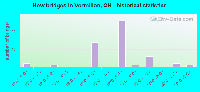
- New bridges - historical statistics
- 21900-1909
- 11920-1929
- 141950-1959
- 261970-1979
- 11980-1989
- 61990-1999
- 22010-2019
- 12020-2022

- Reconstructed bridges - Historical Statistics
- 61980-1989
- 21990-1999


- Bridge Condition - Deck
- 18.2%Excellent
- 6.1%Very good
- 57.6%Good
- 9.1%Satisfactory
- 6.1%Fair
- 3.0%Serious

- Bridge Condition - Superstructure
- 5.9%Excellent
- 32.4%Very good
- 38.2%Good
- 8.8%Satisfactory
- 8.8%Fair
- 2.9%Poor
- 2.9%Serious

- Bridge Condition - Substructure
- 5.9%Excellent
- 17.6%Very good
- 55.9%Good
- 11.8%Satisfactory
- 8.8%Fair

- Bridge Condition - Channel
- 5.6%Excellent
- 5.6%Very good
- 44.4%Good
- 38.9%Satisfactory
- 5.6%Fair

- Bridge Condition - Culverts
- 33.3%Excellent
- 33.3%Good
- 33.3%Satisfactory
Find on map >> Show street view
Structure Number: 220494, Location: OVER SR 60 (Lat: 41.397750, Lng: -82.365061), Route carried "under" structure: State highway 60, Year Built: 1973, Structure Length: 0. m, Average Daily Traffic: 9,365 (year 2015), Truck Traffic: 4%, Features Intersected: UNDER ERI-002 -2962R, Facility Carried by Structure: SR 2
Minimum Vertical Clearance: 4.72m (15.49ft), Kilometerpoint: 13.132, Lanes on structure: 5, Lanes under structure: 4, Material/Design: Steel continuous, Design/Construction: Stringer/Multi-beam, Length of Maximum Span: 16.8m (55.1ft)
Find on map >> Show street view
Structure Number: 2229927, Location: 11.2MI WEST OF EXIT 8A (Lat: 41.338111, Lng: -82.359981), Route carried "under" structure: Interstate 80K, Year Built: 1954, Structure Length: 0. m, Average Daily Traffic: 40,322 (year 2017), Truck Traffic: 35%, Features Intersected: SR60 SAVANNAH-VER RD, Facility Carried by Structure: I80 OHIO TPK
Minimum Vertical Clearance: 4.65m (15.26ft), Kilometerpoint: 41.038, Lanes on structure: 2, Lanes under structure: 6, Toll: On toll road, Material/Design: Steel continuous, Design/Construction: Stringer/Multi-beam, Length of Maximum Span: 22.9m (75.1ft)
Find on map >> Show street view
Structure Number: 2229986, Location: 10.4MI WEST OF EXIT 8A (Lat: 41.343089, Lng: -82.344669), Route carried "under" structure: Interstate 80K, Year Built: 1954, Structure Length: 0. m, Average Daily Traffic: 40,322 (year 2017), Truck Traffic: 35%, Features Intersected: DEAN RD, Facility Carried by Structure: I80 OHIO TPK
Minimum Vertical Clearance: 4.65m (15.26ft), Kilometerpoint: 42.310, Lanes on structure: 2, Lanes under structure: 6, Toll: On toll road, Material/Design: Steel continuous, Design/Construction: Stringer/Multi-beam, Length of Maximum Span: 20.7m (67.9ft)
Find on map >> Show street view
Structure Number: 4707761, Location: .3 MI E OF ERIE CO LINE (Lat: 41.402139, Lng: -82.341169), Route carried "under" structure: State highway 17, Year Built: 1973, Structure Length: 0. m, Average Daily Traffic: 30,401 (year 2015), Truck Traffic: 12%, Features Intersected: UNDER WEST RIVER RD TH-6, Facility Carried by Structure: T-69 WEST RIVER
Minimum Vertical Clearance: 4.50m (14.76ft), Kilometerpoint: 0.483, Lanes on structure: 2, Lanes under structure: 6, Material/Design: Steel continuous, Design/Construction: Stringer/Multi-beam, Length of Maximum Span: 26.8m (87.9ft)
Find on map >> Show street view
Structure Number: 4707834, Location: 1.07 MI E OF ERIE CO LINE (Lat: 41.403331, Lng: -82.326561), Route carried "under" structure: State highway 18, Year Built: 1973, Structure Length: 0. m, Average Daily Traffic: 30,401 (year 2015), Truck Traffic: 11%, Features Intersected: UNDER VERMILION RD TH-70, Facility Carried by Structure: T-70 VERMILION RD
Minimum Vertical Clearance: 6.17m (20.24ft), Kilometerpoint: 1.722, Lanes on structure: 2, Lanes under structure: 4, Material/Design: Steel continuous, Design/Construction: Stringer/Multi-beam, Length of Maximum Span: 20.7m (67.9ft)
Find on map >> Show street view
Structure Number: 470785, Location: 1.51 MI E OF ERIE CO LINE (Lat: 41.403800, Lng: -82.318031), Route carried "under" structure: State highway 19, Year Built: 1973, Structure Length: 0. m, Average Daily Traffic: 24,472 (year 2015), Truck Traffic: 10%, Features Intersected: U/ VERMILION INT CR-7000, Facility Carried by Structure: T-70 Vermilion Rd
Minimum Vertical Clearance: 4.83m (15.85ft), Kilometerpoint: 2.430, Lanes on structure: 2, Lanes under structure: 4, Material/Design: Steel continuous, Design/Construction: Stringer/Multi-beam, Length of Maximum Span: 20.7m (67.9ft)
Find on map >> Show street view
Structure Number: 4707877, Location: 2.23 MI E OF ERIE CO LINE (Lat: 41.403700, Lng: -82.304250), Route carried "under" structure: State highway 20, Year Built: 1973, Structure Length: 0. m, Average Daily Traffic: 26,577 (year 2015), Truck Traffic: 10%, Features Intersected: UNDER SUNNYSIDE RD T624, Facility Carried by Structure: T-624 SUNNYSIDE RD
Minimum Vertical Clearance: 4.62m (15.16ft), Kilometerpoint: 3.589, Lanes on structure: 2, Lanes under structure: 4, Material/Design: Steel continuous, Design/Construction: Stringer/Multi-beam, Length of Maximum Span: 20.7m (67.9ft)
Find on map >> Show street view
Structure Number: 4707893, Location: 2.62 MI E OF ERIE CO LINE (Lat: 41.403600, Lng: -82.296661), Route carried "under" structure: State highway 21, Year Built: 1973, Structure Length: 0. m, Average Daily Traffic: 26,577 (year 2015), Truck Traffic: 10%, Features Intersected: UNDER CLAUS RD TH-97, Facility Carried by Structure: T-97 CLAUS RD
Minimum Vertical Clearance: 4.62m (15.16ft), Kilometerpoint: 4.216, Lanes on structure: 2, Lanes under structure: 4, Material/Design: Steel continuous, Design/Construction: Stringer/Multi-beam, Length of Maximum Span: 20.7m (67.9ft)
Find on map >> Show street view
Structure Number: 4707915, Location: 3.33 MI E OF ERIE CO LINE (Lat: 41.403619, Lng: -82.283111), Route carried "under" structure: County highway 51, Year Built: 1973, Structure Length: 0. m, Average Daily Traffic: 8,435 (year 2015), Truck Traffic: 8%, Features Intersected: UNDER LOR-002 -0333R, Facility Carried by Structure: SR 2
Minimum Vertical Clearance: 4.65m (15.26ft), Kilometerpoint: 1.609, Lanes on structure: 2, Lanes under structure: 4, Material/Design: Steel continuous, Design/Construction: Stringer/Multi-beam, Length of Maximum Span: 13.4m (44.0ft)
Find on map >> Show street view
Structure Number: 4707923, Location: 3.33 MI E OF ERIE CO LINE (Lat: 41.403800, Lng: -82.283119), Route carried "under" structure: County highway 51, Year Built: 1973, Structure Length: 0. m, Average Daily Traffic: 8,435 (year 2015), Truck Traffic: 8%, Features Intersected: UNDER LOR-002 -0333L, Facility Carried by Structure: SR 2
Minimum Vertical Clearance: 4.83m (15.85ft), Kilometerpoint: 1.593, Lanes on structure: 2, Lanes under structure: 4, Material/Design: Steel continuous, Design/Construction: Stringer/Multi-beam, Length of Maximum Span: 13.4m (44.0ft)
Find on map >> Show street view
Structure Number: 4728793, Location: 9.7MI WEST OF EXIT 8A (Lat: 41.344850, Lng: -82.332019), Route carried "under" structure: Interstate 80K, Year Built: 1954, Structure Length: 0. m, Average Daily Traffic: 40,573 (year 2015), Truck Traffic: 27%, Features Intersected: GORE-ORPHANAGE RD, Facility Carried by Structure: I80 OHIO TPK
Minimum Vertical Clearance: 4.47m (14.67ft), Kilometerpoint: 1.078, Lanes on structure: 2, Lanes under structure: 6, Toll: On toll road, Material/Design: Steel continuous, Design/Construction: Stringer/Multi-beam, Length of Maximum Span: 20.1m (65.9ft)
Find on map >> Show street view
Structure Number: 4728831, Location: 7.8MI WEST OF EXIT 8A (Lat: 41.354511, Lng: -82.298919), Route carried "under" structure: Interstate 80K, Year Built: 1954, Structure Length: 0. m, Average Daily Traffic: 40,573 (year 2015), Truck Traffic: 27%, Features Intersected: VERMILION RD, Facility Carried by Structure: I80 OHIO TPK
Minimum Vertical Clearance: 4.55m (14.93ft), Kilometerpoint: 4.056, Lanes on structure: 2, Lanes under structure: 6, Toll: On toll road, Material/Design: Steel continuous, Design/Construction: Stringer/Multi-beam, Length of Maximum Span: 17.7m (58.1ft)
Find on map >> Show street view
Structure Number: 4728882, Location: 7.4MI WEST OF EXIT 8A (Lat: 41.357061, Lng: -82.292481), Route carried "under" structure: Interstate 80K, Year Built: 1954, Structure Length: 0. m, Average Daily Traffic: 40,573 (year 2015), Truck Traffic: 27%, Features Intersected: GIFFORD RD, Facility Carried by Structure: I80 OHIO TPK
Minimum Vertical Clearance: 4.52m (14.83ft), Kilometerpoint: 4.667, Lanes on structure: 2, Lanes under structure: 6, Toll: On toll road, Material/Design: Steel continuous, Design/Construction: Stringer/Multi-beam, Length of Maximum Span: 20.4m (66.9ft)