Bridge Statistics for Tysons Corner, Virginia (VA)
Condition, Traffic, Stress, Structural Evaluation, Project Costs
- National Bridge Inventory (NBI) Statistics
- 94Number of bridges
- 856ft / 261mTotal length
- $3,821,000Total costs
- 3,073,042Total average daily traffic
- 73,996Total average daily truck traffic
- National Bridge Inventory (NBI) Registered Bridges for Tysons Corner
- No street view available for this location
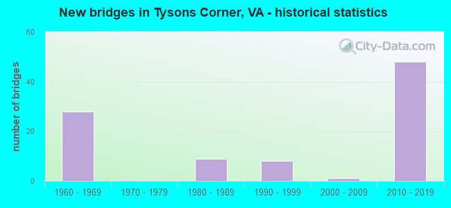
- New bridges - historical statistics
- 281960-1969
- 91980-1989
- 81990-1999
- 12000-2009
- 482010-2019


- Bridge Condition - Deck
- 3.2%Excellent
- 64.5%Good
- 6.5%Satisfactory
- 25.8%Fair

- Bridge Condition - Superstructure
- 3.2%Excellent
- 29.0%Very good
- 32.3%Good
- 12.9%Satisfactory
- 19.4%Fair
- 3.2%Poor

- Bridge Condition - Substructure
- 3.2%Excellent
- 9.7%Very good
- 61.3%Good
- 9.7%Satisfactory
- 16.1%Fair

- Bridge Condition - Channel
- 33.3%Good
- 33.3%Satisfactory
- 33.3%Fair

- Bridge Condition - Culverts
- 25.0%Good
- 50.0%Satisfactory
- 25.0%Fair
Find on map >> Show street view
Structure Number: 6511, Location: 00.40FR495/02.25TO66 (Lat: 38.928894, Lng: -77.203892), Route carried "under" structure: State highway 123, Year Built: 1983, Structure Length: 0. m, Average Daily Traffic: 44,046 (year 2008), Features Intersected: DOLLEY MADISON BLVD(123), Facility Carried by Structure: DULLES A. RD. EBL
Minimum Vertical Clearance: 5.72m (18.77ft), Kilometerpoint: 38.536, Lanes on structure: 2, Lanes under structure: 3, Material/Design: Concrete continuous, Design/Construction: Box Beam or Girders - Multiple, Length of Maximum Span: 42.7m (140.1ft)
Find on map >> Show street view
Structure Number: 6511, Location: 00.40FR495/02.25TO66 (Lat: 38.928894, Lng: -77.203892), Route carried "under" structure: State highway 123, Year Built: 1983, Structure Length: 0. m, Average Daily Traffic: 23,000 (year 1994), Features Intersected: DOLLEY MADISON BLVD(123), Facility Carried by Structure: DULLES A. RD. EBL
Minimum Vertical Clearance: 5.08m (16.67ft), Kilometerpoint: 0.000, Lanes on structure: 2, Lanes under structure: 3, Material/Design: Concrete continuous, Design/Construction: Box Beam or Girders - Multiple, Length of Maximum Span: 42.7m (140.1ft)
Find on map >> Show street view
Structure Number: 6612, Location: 00.65 123 / 01.94 193 (Lat: 38.930969, Lng: -77.213925), Route carried "under" structure: Other road 495, Year Built: 1964, Structure Length: 0. m, Average Daily Traffic: 50,000 (year 1994), Features Intersected: RMP EN OF DUL AIR RD, Facility Carried by Structure: CAPITAL BELTWAY OL
Minimum Vertical Clearance: 5.08m (16.67ft), Kilometerpoint: 0.257, Lanes on structure: 4, Lanes under structure: 1, Material/Design: Steel, Design/Construction: Stringer/Multi-beam, Length of Maximum Span: 15.8m (51.8ft)
Find on map >> Show street view
Structure Number: 6612, Location: 00.65 123 / 01.94 193 (Lat: 38.930969, Lng: -77.213925), Route carried "under" structure: Other road 495, Year Built: 1964, Structure Length: 0. m, Average Daily Traffic: 50,000 (year 1994), Features Intersected: RMP EN OF DUL AIR RD, Facility Carried by Structure: CAPITAL BELTWAY OL
Minimum Vertical Clearance: 5.11m (16.77ft), Kilometerpoint: 0.257, Lanes on structure: 4, Lanes under structure: 1, Material/Design: Steel, Design/Construction: Stringer/Multi-beam, Length of Maximum Span: 15.8m (51.8ft)
Find on map >> Show street view
Structure Number: 6612, Location: 00.65 123 / 01.94 193 (Lat: 38.930969, Lng: -77.213925), Route carried "under" structure: Other road 495, Year Built: 1964, Structure Length: 0. m, Average Daily Traffic: 50,000 (year 1994), Features Intersected: RMP EN OF DUL AIR RD, Facility Carried by Structure: CAPITAL BELTWAY OL
Minimum Vertical Clearance: 5.18m (16.99ft), Kilometerpoint: 0.257, Lanes on structure: 4, Lanes under structure: 1, Material/Design: Steel, Design/Construction: Stringer/Multi-beam, Length of Maximum Span: 15.8m (51.8ft)
Find on map >> Show street view
Structure Number: 6614, Location: 00.74FR123/01.85TO193 (Lat: 38.931917, Lng: -77.213350), Route carried "under" structure: State highway 267, Year Built: 1963, Structure Length: 0. m, Average Daily Traffic: 20,000 (year 1996), Truck Traffic: 3%, Features Intersected: DUL.ACC.RD.&EBL RTE.267, Facility Carried by Structure: CAPITAL BELTWAY SB
Minimum Vertical Clearance: 4.67m (15.32ft), Kilometerpoint: 18.231, Lanes on structure: 5, Lanes under structure: 2, Toll: On toll road, Material/Design: Steel, Design/Construction: Stringer/Multi-beam, Length of Maximum Span: 22.6m (74.1ft)
Find on map >> Show street view
Structure Number: 6614, Location: 00.74FR123/01.85TO193 (Lat: 38.931917, Lng: -77.213350), Route carried "under" structure: ServiceUS , Year Built: 1963, Structure Length: 0. m, Average Daily Traffic: 20,000 (year 1996), Truck Traffic: 3%, Features Intersected: DUL.ACC.RD.&EBL RTE.267, Facility Carried by Structure: CAPITAL BELTWAY SB
Minimum Vertical Clearance: 4.47m (14.67ft), Kilometerpoint: 0.000, Lanes on structure: 5, Lanes under structure: 2, Material/Design: Steel, Design/Construction: Stringer/Multi-beam, Length of Maximum Span: 22.6m (74.1ft)
Find on map >> Show street view
Structure Number: 6614, Location: 00.74FR123/01.85TO193 (Lat: 38.931917, Lng: -77.213350), Route carried "under" structure: ServiceUS , Year Built: 1963, Structure Length: 0. m, Average Daily Traffic: 20,000 (year 1996), Truck Traffic: 3%, Features Intersected: DUL.ACC.RD.&EBL RTE.267, Facility Carried by Structure: CAPITAL BELTWAY SB
Minimum Vertical Clearance: 4.83m (15.85ft), Kilometerpoint: 0.000, Lanes on structure: 5, Lanes under structure: 2, Toll: On toll road, Material/Design: Steel, Design/Construction: Stringer/Multi-beam, Length of Maximum Span: 22.6m (74.1ft)
Find on map >> Show street view
Structure Number: 6614, Location: 00.74FR123/01.85TO193 (Lat: 38.931917, Lng: -77.213350), Route carried "under" structure: Ramp Federal lands road 267, Year Built: 1963, Structure Length: 0. m, Average Daily Traffic: 44,550 (year 1994), Features Intersected: DUL.ACC.RD.&EBL RTE.267, Facility Carried by Structure: CAPITAL BELTWAY SB
Minimum Vertical Clearance: 5.03m (16.50ft), Kilometerpoint: 18.230, Lanes on structure: 5, Lanes under structure: 1, Material/Design: Steel, Design/Construction: Stringer/Multi-beam, Length of Maximum Span: 22.6m (74.1ft)
Find on map >> Show street view
Structure Number: 6618, Location: 00.58FR123/02.01TO193 (Lat: 38.929400, Lng: -77.211300), Route carried "under" structure: Federal lands road 495, Year Built: 1964, Structure Length: 0. m, Average Daily Traffic: 3,200 (year 1994), Features Intersected: RAMP EN OF DULLES TOLL R, Facility Carried by Structure: CAPITAL BELTWAY IL
Minimum Vertical Clearance: 4.42m (14.50ft), Kilometerpoint: 0.563, Lanes on structure: 5, Lanes under structure: 1, Material/Design: Steel, Design/Construction: Stringer/Multi-beam, Length of Maximum Span: 16.8m (55.1ft)
Find on map >> Show street view
Structure Number: 662, Location: 00.71FR123/01.88TO193 (Lat: 38.930792, Lng: -77.210611), Route carried "under" structure: Other road 267, Year Built: 1961, Structure Length: 0. m, Average Daily Traffic: 40,500 (year 2003), Features Intersected: EBL DULL. TOLL & RAMP SE, Facility Carried by Structure: NBL CAPT. BELTWAY
Minimum Vertical Clearance: 4.42m (14.50ft), Kilometerpoint: 18.230, Lanes on structure: 5, Lanes under structure: 3, Toll: On toll road, Material/Design: Steel, Design/Construction: Stringer/Multi-beam, Length of Maximum Span: 25.9m (85.0ft)
Find on map >> Show street view
Structure Number: 662, Location: 00.71FR123/01.88TO193 (Lat: 38.930792, Lng: -77.210611), Route carried "under" structure: Alternate Other road 267, Year Built: 1961, Structure Length: 0. m, Average Daily Traffic: 40,500 (year 2003), Features Intersected: EBL DULL. TOLL & RAMP SE, Facility Carried by Structure: NBL CAPT. BELTWAY
Minimum Vertical Clearance: 4.57m (14.99ft), Kilometerpoint: 18.230, Lanes on structure: 5, Lanes under structure: 2, Toll: Toll bridge, Material/Design: Steel, Design/Construction: Stringer/Multi-beam, Length of Maximum Span: 25.9m (85.0ft)
Find on map >> Show street view
Structure Number: 662, Location: 00.71FR123/01.88TO193 (Lat: 38.930792, Lng: -77.210611), Route carried "under" structure: Alternate Other road 267, Year Built: 1961, Structure Length: 0. m, Average Daily Traffic: 40,500 (year 1994), Features Intersected: EBL DULL. TOLL & RAMP SE, Facility Carried by Structure: NBL CAPT. BELTWAY
Minimum Vertical Clearance: 4.50m (14.76ft), Kilometerpoint: 18.230, Lanes on structure: 5, Lanes under structure: 2, Toll: Toll bridge, Material/Design: Steel, Design/Construction: Stringer/Multi-beam, Length of Maximum Span: 25.9m (85.0ft)
Find on map >> Show street view
Structure Number: 6626, Location: 0.10FR267EB 0.05TO495NBL (Lat: 38.930639, Lng: -77.209847), Route carried "under" structure: Ramp Federal lands road 267, Year Built: 1961, Structure Length: 0. m, Average Daily Traffic: 122,164 (year 2008), Features Intersected: DAR AND TOLL RD. EXT. EB, Facility Carried by Structure: RAMP TO N.B. 495
Minimum Vertical Clearance: 4.60m (15.09ft), Kilometerpoint: 41.416, Lanes on structure: 1, Lanes under structure: 3, Toll: Toll bridge, Material/Design: Steel, Design/Construction: Stringer/Multi-beam, Length of Maximum Span: 28.3m (92.8ft)
Find on map >> Show street view
Structure Number: 6626, Location: 0.10FR267EB 0.05TO495NBL (Lat: 38.930639, Lng: -77.209847), Route carried "under" structure: Ramp Federal lands road 267, Year Built: 1961, Structure Length: 0. m, Average Daily Traffic: 44,000 (year 2008), Features Intersected: DAR AND TOLL RD. EXT. EB, Facility Carried by Structure: RAMP TO N.B. 495
Minimum Vertical Clearance: 4.95m (16.24ft), Kilometerpoint: 20.466, Lanes on structure: 1, Lanes under structure: 2, Toll: Toll bridge, Material/Design: Steel, Design/Construction: Stringer/Multi-beam, Length of Maximum Span: 28.3m (92.8ft)
Find on map >> Show street view
Structure Number: 6626, Location: 0.10FR267EB 0.05TO495NBL (Lat: 38.930639, Lng: -77.209847), Route carried "under" structure: Ramp Federal lands road 267, Year Built: 1961, Structure Length: 0. m, Average Daily Traffic: 44,000 (year 2008), Features Intersected: DAR AND TOLL RD. EXT. EB, Facility Carried by Structure: RAMP TO N.B. 495
Minimum Vertical Clearance: 4.62m (15.16ft), Kilometerpoint: 20.483, Lanes on structure: 1, Lanes under structure: 2, Toll: Toll bridge, Material/Design: Steel, Design/Construction: Stringer/Multi-beam, Length of Maximum Span: 28.3m (92.8ft)
Find on map >> Show street view
Structure Number: 7037, Location: 0.05fr ShTys/0.12to Galle (Lat: 38.920989, Lng: -77.218861), Route carried "under" structure: State highway 123, Year Built: 1991, Structure Length: 0. m, Average Daily Traffic: 32,580 (year 2000), Features Intersected: RTE. 123 CHAINBRIDGE RD., Facility Carried by Structure: WESTPARK DRIVE
Minimum Vertical Clearance: 5.46m (17.91ft), Kilometerpoint: 0.000, Lanes on structure: 4, Lanes under structure: 3, Material/Design: Steel continuous, Design/Construction: Stringer/Multi-beam, Length of Maximum Span: 63.0m (206.7ft)
Find on map >> Show street view
Structure Number: 7037, Location: 0.05fr ShTys/0.12to Galle (Lat: 38.920989, Lng: -77.218861), Route carried "under" structure: State highway 123, Year Built: 1991, Structure Length: 0. m, Average Daily Traffic: 32,580 (year 2000), Truck Traffic: 2%, Features Intersected: RTE. 123 CHAINBRIDGE RD., Facility Carried by Structure: WESTPARK DRIVE
Minimum Vertical Clearance: 5.36m (17.59ft), Kilometerpoint: 0.000, Lanes on structure: 4, Lanes under structure: 4, Material/Design: Steel continuous, Design/Construction: Stringer/Multi-beam, Length of Maximum Span: 63.0m (206.7ft)
Find on map >> Show street view
Structure Number: 7037, Location: 0.05fr ShTys/0.12to Galle (Lat: 38.920989, Lng: -77.218861), Route carried "under" structure: State highway 123, Year Built: 1991, Structure Length: 0. m, Average Daily Traffic: 18,340 (year 2008), Truck Traffic: 1%, Features Intersected: RTE. 123 CHAINBRIDGE RD., Facility Carried by Structure: WESTPARK DRIVE
Minimum Vertical Clearance: 5.51m (18.08ft), Kilometerpoint: 0.000, Lanes on structure: 4, Lanes under structure: 1, Material/Design: Steel continuous, Design/Construction: Stringer/Multi-beam, Length of Maximum Span: 63.0m (206.7ft)
Find on map >> Show street view
Structure Number: 7037, Location: 0.05fr ShTys/0.12to Galle (Lat: 38.920989, Lng: -77.218861), Route carried "under" structure: Ramp State highway 123, Year Built: 1991, Structure Length: 0. m, Features Intersected: RTE. 123 CHAINBRIDGE RD., Facility Carried by Structure: WESTPARK DRIVE
Minimum Vertical Clearance: 5.79m (19.00ft), Kilometerpoint: 0.000, Lanes on structure: 4, Lanes under structure: 1, Material/Design: Steel continuous, Design/Construction: Stringer/Multi-beam, Length of Maximum Span: 63.0m (206.7ft)
Find on map >> Show street view
Structure Number: 7037, Location: 0.05fr ShTys/0.12to Galle (Lat: 38.920989, Lng: -77.218861), Route carried "under" structure: Ramp Interstate 495, Year Built: 1991, Structure Length: 0. m, Average Daily Traffic: 36,509 (year 2008), Truck Traffic: 2%, Features Intersected: RTE. 123 CHAINBRIDGE RD., Facility Carried by Structure: WESTPARK DRIVE
Minimum Vertical Clearance: 5.46m (17.91ft), Kilometerpoint: 0.000, Lanes on structure: 4, Lanes under structure: 2, Material/Design: Steel continuous, Design/Construction: Stringer/Multi-beam, Length of Maximum Span: 63.0m (206.7ft)
Find on map >> Show street view
Structure Number: 2868, Location: 00.80FR0007/02.58TO0193 (Lat: 38.921564, Lng: -77.215789), Route carried "under" structure: State highway 123, Year Built: 2011, Structure Length: 0. m, Average Daily Traffic: 60,000 (year 2011), Features Intersected: ROUTE 123, Facility Carried by Structure: RAMP NBH & I-495NB
Minimum Vertical Clearance: 5.05m (16.57ft), Kilometerpoint: 0.000, Lanes on structure: 7, Lanes under structure: 4, Material/Design: Steel continuous, Design/Construction: Stringer/Multi-beam, Length of Maximum Span: 37.8m (124.0ft)
Find on map >> Show street view
Structure Number: 2868, Location: 00.80FR0007/02.58TO0193 (Lat: 38.921564, Lng: -77.215789), Route carried "under" structure: US 123, Year Built: 2011, Structure Length: 0. m, Average Daily Traffic: 60,000 (year 2011), Truck Traffic: 1%, Features Intersected: ROUTE 123, Facility Carried by Structure: RAMP NBH & I-495NB
Minimum Vertical Clearance: 5.39m (17.68ft), Kilometerpoint: 1.609, Lanes on structure: 7, Lanes under structure: 4, Material/Design: Steel continuous, Design/Construction: Stringer/Multi-beam, Length of Maximum Span: 37.8m (124.0ft)
Find on map >> Show street view
Structure Number: 28681, Location: 2.52 Mi. North of I-66 (Lat: 38.921497, Lng: -77.215942), Route carried "under" structure: Business County highway 123, Year Built: 2012, Structure Length: 0. m, Average Daily Traffic: 114,000 (year 2012), Truck Traffic: 1%, Features Intersected: ROUTE 123, Facility Carried by Structure: RAMPS TNWH & TWNH
Minimum Vertical Clearance: 8.25m (27.07ft), Kilometerpoint: 0.000, Lanes on structure: 3, Lanes under structure: 8, Material/Design: Concrete, Design/Construction: Stringer/Multi-beam, Length of Maximum Span: 37.6m (123.4ft)
Find on map >> Show street view
Structure Number: 28682, Location: 00.78FR0007/00.80TO0267 (Lat: 38.921147, Lng: -77.216811), Route carried "under" structure: State highway 123, Year Built: 2010, Structure Length: 0. m, Average Daily Traffic: 38,560 (year 2000), Truck Traffic: 5%, Features Intersected: RTE.123, Facility Carried by Structure: I-495 SB & SBH
Minimum Vertical Clearance: 5.72m (18.77ft), Kilometerpoint: 0.000, Lanes on structure: 7, Lanes under structure: 4, Material/Design: Steel continuous, Design/Construction: Stringer/Multi-beam, Length of Maximum Span: 37.0m (121.4ft)
Find on map >> Show street view
Structure Number: 28682, Location: 00.78FR0007/00.80TO0267 (Lat: 38.921147, Lng: -77.216811), Route carried "under" structure: State highway 123, Year Built: 2010, Structure Length: 0. m, Average Daily Traffic: 45,670 (year 2000), Truck Traffic: 5%, Features Intersected: RTE.123, Facility Carried by Structure: I-495 SB & SBH
Minimum Vertical Clearance: 6.22m (20.41ft), Kilometerpoint: 0.000, Lanes on structure: 7, Lanes under structure: 4, Material/Design: Steel continuous, Design/Construction: Stringer/Multi-beam, Length of Maximum Span: 37.0m (121.4ft)
Find on map >> Show street view
Structure Number: 28683, Location: 0.01FR5061/0.01ToNBhtlane (Lat: 38.920139, Lng: -77.217839), Route carried "under" structure: Ramp Interstate 495, Year Built: 2012, Structure Length: 0. m, Average Daily Traffic: 10,000 (year 2012), Truck Traffic: 2%, Features Intersected: RAMP CNE; 495 SB, Facility Carried by Structure: W.Park T Connector
Minimum Vertical Clearance: 5.43m (17.81ft), Kilometerpoint: 0.000, Lanes on structure: 4, Lanes under structure: 7, Material/Design: Concrete, Design/Construction: Slab, Length of Maximum Span: 56.9m (186.7ft)
Find on map >> Show street view
Structure Number: 28685, Location: 0.40fr694 0.70to 123 (Lat: 38.929917, Lng: -77.212500), Route carried "under" structure: Ramp Other road 267, Year Built: 2012, Structure Length: 0. m, Average Daily Traffic: 30,000 (year 2012), Truck Traffic: 1%, Features Intersected: RAMPS DTWSH & FUTURE, Facility Carried by Structure: SBH 495
Minimum Vertical Clearance: 5.87m (19.26ft), Kilometerpoint: 0.000, Lanes on structure: 2, Lanes under structure: 1, Toll: On toll road, Material/Design: Steel continuous, Design/Construction: Stringer/Multi-beam, Length of Maximum Span: 43.7m (143.4ft)
Find on map >> Show street view
Structure Number: 28685, Location: 0.40fr694 0.70to 123 (Lat: 38.929917, Lng: -77.212500), Route carried "under" structure: Other road 267, Year Built: 2012, Structure Length: 0. m, Average Daily Traffic: 38,000 (year 2012), Truck Traffic: 3%, Features Intersected: RAMPS DTWSH & FUTURE, Facility Carried by Structure: SBH 495
Minimum Vertical Clearance: 6.50m (21.33ft), Kilometerpoint: 0.000, Lanes on structure: 2, Lanes under structure: 2, Toll: On toll road, Material/Design: Steel continuous, Design/Construction: Stringer/Multi-beam, Length of Maximum Span: 43.7m (143.4ft)
Find on map >> Show street view
Structure Number: 28686, Location: 3.2 North of I66 (Lat: 38.930747, Lng: -77.211364), Route carried "under" structure: Ramp Interstate 495, Year Built: 2012, Structure Length: 0. m, Features Intersected: RAMP DSE, Facility Carried by Structure: RAMP NBH
Minimum Vertical Clearance: 6.78m (22.24ft), Kilometerpoint: 0.000, Lanes on structure: 2, Lanes under structure: 1, Material/Design: Prestressed concrete, Design/Construction: Stringer/Multi-beam, Length of Maximum Span: 36.6m (120.1ft)
Find on map >> Show street view
Structure Number: 28687, Location: 3.2 Miles North of I-66 (Lat: 38.930672, Lng: -77.212003), Route carried "under" structure: Business State highway 267, Year Built: 2012, Structure Length: 0. m, Average Daily Traffic: 40,000 (year 2012), Truck Traffic: 4%, Features Intersected: RAMP DSE, Facility Carried by Structure: SBH 495
Minimum Vertical Clearance: 5.26m (17.26ft), Kilometerpoint: 0.000, Lanes on structure: 2, Lanes under structure: 1, Material/Design: Concrete, Design/Construction: Stringer/Multi-beam, Length of Maximum Span: 30.5m (100.1ft)
Find on map >> Show street view
Structure Number: 28688, Location: 0.75 fr 7 1.87 to 193 (Lat: 38.931178, Lng: -77.211033), Route carried "under" structure: Alternate Other road 267, Year Built: 2012, Structure Length: 0. m, Average Daily Traffic: 15,000 (year 2012), Truck Traffic: 1%, Features Intersected: DTR and DAAR, Facility Carried by Structure: 495 NBH & JBEWN
Minimum Vertical Clearance: 8.79m (28.84ft), Kilometerpoint: 0.000, Lanes on structure: 3, Lanes under structure: 2, Material/Design: Prestressed concrete, Design/Construction: Stringer/Multi-beam, Length of Maximum Span: 30.5m (100.1ft)
Find on map >> Show street view
Structure Number: 28688, Location: 0.75 fr 7 1.87 to 193 (Lat: 38.931178, Lng: -77.211033), Route carried "under" structure: Other road 267, Year Built: 2012, Structure Length: 0. m, Average Daily Traffic: 38,000 (year 2012), Truck Traffic: 1%, Features Intersected: DTR and DAAR, Facility Carried by Structure: 495 NBH & JBEWN
Minimum Vertical Clearance: 8.10m (26.57ft), Kilometerpoint: 0.000, Lanes on structure: 3, Lanes under structure: 2, Toll: On toll road, Material/Design: Prestressed concrete, Design/Construction: Stringer/Multi-beam, Length of Maximum Span: 30.5m (100.1ft)
Find on map >> Show street view
Structure Number: 28688, Location: 0.75 fr 7 1.87 to 193 (Lat: 38.931178, Lng: -77.211033), Route carried "under" structure: Alternate Other road 267, Year Built: 2012, Structure Length: 0. m, Average Daily Traffic: 15,000 (year 2012), Truck Traffic: 1%, Features Intersected: DTR and DAAR, Facility Carried by Structure: 495 NBH & JBEWN
Minimum Vertical Clearance: 8.94m (29.33ft), Kilometerpoint: 0.000, Lanes on structure: 3, Lanes under structure: 2, Material/Design: Prestressed concrete, Design/Construction: Stringer/Multi-beam, Length of Maximum Span: 30.5m (100.1ft)
Find on map >> Show street view
Structure Number: 28812, Location: .20fr5062 0.33to123 (Lat: 38.928611, Lng: -77.213278), Route carried "under" structure: Ramp Interstate 267, Year Built: 2012, Structure Length: 0. m, Average Daily Traffic: 35,000 (year 2012), Truck Traffic: 1%, Features Intersected: SBH and DTWSH, Facility Carried by Structure: Scotts Crossing Rd
Minimum Vertical Clearance: 9.53m (31.27ft), Kilometerpoint: 0.000, Lanes on structure: 2, Lanes under structure: 1, Material/Design: Steel, Design/Construction: Stringer/Multi-beam, Length of Maximum Span: 39.0m (128.0ft)
Find on map >> Show street view
Structure Number: 28812, Location: .20fr5062 0.33to123 (Lat: 38.928611, Lng: -77.213278), Route carried "under" structure: Ramp Interstate 267, Year Built: 2012, Structure Length: 0. m, Average Daily Traffic: 46,000 (year 2012), Truck Traffic: 2%, Features Intersected: SBH and DTWSH, Facility Carried by Structure: Scotts Crossing Rd
Minimum Vertical Clearance: 7.04m (23.10ft), Kilometerpoint: 0.000, Lanes on structure: 2, Lanes under structure: 2, Material/Design: Steel, Design/Construction: Stringer/Multi-beam, Length of Maximum Span: 39.0m (128.0ft)
Find on map >> Show street view
Structure Number: 28813, Location: 00.50 JB old / 0.50 495 (Lat: 38.929528, Lng: -77.212164), Route carried "under" structure: Ramp Other road 267, Year Built: 2012, Structure Length: 0. m, Average Daily Traffic: 10,000 (year 2012), Truck Traffic: 4%, Features Intersected: RAMPS DWN & DTWHN, Facility Carried by Structure: JONES BRANCH NEW
Minimum Vertical Clearance: 8.41m (27.59ft), Kilometerpoint: 0.000, Lanes on structure: 2, Lanes under structure: 1, Material/Design: Prestressed concrete continuous, Design/Construction: Stringer/Multi-beam, Length of Maximum Span: 25.9m (85.0ft)
Find on map >> Show street view
Structure Number: 28814, Location: 3.2 Miles N. of I-66 (Lat: 38.930658, Lng: -77.211778), Route carried "under" structure: Other road 267, Year Built: 2012, Structure Length: 0. m, Average Daily Traffic: 20,000 (year 2012), Truck Traffic: 3%, Features Intersected: RAMP DSE, Facility Carried by Structure: JONES BRANCH NEW
Minimum Vertical Clearance: 6.00m (19.69ft), Kilometerpoint: 0.000, Lanes on structure: 1, Lanes under structure: 1, Toll: On toll road, Material/Design: Prestressed concrete, Design/Construction: Stringer/Multi-beam, Length of Maximum Span: 29.1m (95.5ft)
Find on map >> Show street view
Structure Number: 28816, Location: 3.11 Miles North of I-66 (Lat: 38.929250, Lng: -77.214417), Route carried "under" structure: Interstate 495, Year Built: 2012, Structure Length: 0. m, Average Daily Traffic: 25,000 (year 2012), Truck Traffic: 3%, Features Intersected: 495-SB & RAMP DES, Facility Carried by Structure: Scotts Crossing Rd
Minimum Vertical Clearance: 6.50m (21.33ft), Kilometerpoint: 0.000, Lanes on structure: 4, Lanes under structure: 2, Material/Design: Steel, Design/Construction: Stringer/Multi-beam, Length of Maximum Span: 48.8m (160.1ft)
Find on map >> Show street view
Structure Number: 28816, Location: 3.11 Miles North of I-66 (Lat: 38.929250, Lng: -77.214417), Route carried "under" structure: Interstate 495, Year Built: 2012, Structure Length: 0. m, Average Daily Traffic: 45,000 (year 2012), Truck Traffic: 4%, Features Intersected: 495-SB & RAMP DES, Facility Carried by Structure: Scotts Crossing Rd
Minimum Vertical Clearance: 8.05m (26.41ft), Kilometerpoint: 0.000, Lanes on structure: 4, Lanes under structure: 4, Material/Design: Steel, Design/Construction: Stringer/Multi-beam, Length of Maximum Span: 48.8m (160.1ft)
Find on map >> Show street view
Structure Number: 28817, Location: 3.2 Miles North of I-66 (Lat: 38.930703, Lng: -77.211628), Route carried "under" structure: Ramp Interstate 495, Year Built: 2012, Structure Length: 0. m, Features Intersected: RAMP DSE, Facility Carried by Structure: RAMP JB EWN
Minimum Vertical Clearance: 6.88m (22.57ft), Kilometerpoint: 0.000, Lanes on structure: 1, Lanes under structure: 1, Material/Design: Concrete continuous, Design/Construction: Stringer/Multi-beam, Length of Maximum Span: 32.9m (107.9ft)
Find on map >> Show street view
Structure Number: 28819, Location: 3.11 Miles North of I-66 (Lat: 38.929569, Lng: -77.211450), Route carried "under" structure: Ramp Interstate 495, Year Built: 2012, Structure Length: 0. m, Average Daily Traffic: 50,000 (year 2012), Truck Traffic: 15%, Features Intersected: RAMP DWN, Facility Carried by Structure: RAMP DTSWN
Minimum Vertical Clearance: 6.10m (20.01ft), Kilometerpoint: 0.000, Lanes on structure: 1, Lanes under structure: 1, Material/Design: Concrete, Design/Construction: Slab, Length of Maximum Span: 19.5m (64.0ft)
Find on map >> Show street view
Structure Number: 2882, Location: 0.75FR 123 & 01.60TO 193 (Lat: 38.930456, Lng: -77.211017), Route carried "under" structure: Ramp Other road 267, Year Built: 2012, Structure Length: 0. m, Average Daily Traffic: 22,000 (year 2012), Truck Traffic: 2%, Features Intersected: RAMP DSE & DTR; DAR, Facility Carried by Structure: RAMP DTSWH
Minimum Vertical Clearance: 7.85m (25.75ft), Kilometerpoint: 0.000, Lanes on structure: 1, Lanes under structure: 1, Toll: On toll road, Material/Design: Steel continuous, Design/Construction: Stringer/Multi-beam, Length of Maximum Span: 42.1m (138.1ft)
Find on map >> Show street view
Structure Number: 2882, Location: 0.75FR 123 & 01.60TO 193 (Lat: 38.930456, Lng: -77.211017), Route carried "under" structure: Other road 267, Year Built: 2012, Structure Length: 0. m, Average Daily Traffic: 26,000 (year 2012), Truck Traffic: 2%, Features Intersected: RAMP DSE & DTR; DAR, Facility Carried by Structure: RAMP DTSWH
Minimum Vertical Clearance: 5.43m (17.81ft), Kilometerpoint: 0.000, Lanes on structure: 1, Lanes under structure: 2, Toll: On toll road, Material/Design: Steel continuous, Design/Construction: Stringer/Multi-beam, Length of Maximum Span: 42.1m (138.1ft)
Find on map >> Show street view
Structure Number: 2882, Location: 0.75FR 123 & 01.60TO 193 (Lat: 38.930456, Lng: -77.211017), Route carried "under" structure: Other road 267, Year Built: 2012, Structure Length: 0. m, Average Daily Traffic: 16,000 (year 2012), Truck Traffic: 2%, Features Intersected: RAMP DSE & DTR; DAR, Facility Carried by Structure: RAMP DTSWH
Minimum Vertical Clearance: 6.27m (20.57ft), Kilometerpoint: 0.000, Lanes on structure: 1, Lanes under structure: 2, Toll: On toll road, Material/Design: Steel continuous, Design/Construction: Stringer/Multi-beam, Length of Maximum Span: 42.1m (138.1ft)
Find on map >> Show street view
Structure Number: 2882, Location: 0.75FR 123 & 01.60TO 193 (Lat: 38.930456, Lng: -77.211017), Route carried "under" structure: Other road 267, Year Built: 2012, Structure Length: 0. m, Average Daily Traffic: 25,000 (year 2012), Truck Traffic: 2%, Features Intersected: RAMP DSE & DTR; DAR, Facility Carried by Structure: RAMP DTSWH
Minimum Vertical Clearance: 6.73m (22.08ft), Kilometerpoint: 0.000, Lanes on structure: 1, Lanes under structure: 2, Toll: On toll road, Material/Design: Steel continuous, Design/Construction: Stringer/Multi-beam, Length of Maximum Span: 42.1m (138.1ft)
Find on map >> Show street view
Structure Number: 29963, Location: 0.68 fr 7 1.82 to 193 (Lat: 38.929814, Lng: -77.211861), Route carried "under" structure: Ramp Other road 267, Year Built: 2012, Structure Length: 0. m, Average Daily Traffic: 18,000 (year 2012), Truck Traffic: 1%, Features Intersected: 267 ramp DWN, Facility Carried by Structure: 495 NBH
Minimum Vertical Clearance: 5.46m (17.91ft), Kilometerpoint: 0.000, Lanes on structure: 2, Lanes under structure: 1, Toll: On toll road, Material/Design: Prestressed concrete continuous, Design/Construction: Stringer/Multi-beam, Length of Maximum Span: 28.7m (94.2ft)
Find on map >> Show street view
Structure Number: 29963, Location: 0.68 fr 7 1.82 to 193 (Lat: 38.929814, Lng: -77.211861), Route carried "under" structure: Ramp Other road 267, Year Built: 2012, Structure Length: 0. m, Average Daily Traffic: 16,000 (year 2012), Truck Traffic: 1%, Features Intersected: 267 ramp DWN, Facility Carried by Structure: 495 NBH
Minimum Vertical Clearance: 5.36m (17.59ft), Kilometerpoint: 0.000, Lanes on structure: 2, Lanes under structure: 1, Toll: On toll road, Material/Design: Prestressed concrete continuous, Design/Construction: Stringer/Multi-beam, Length of Maximum Span: 28.7m (94.2ft)
Find on map >> Show street view
Structure Number: 30122, Location: 00.40fr JB 00.25to123_ (Lat: 38.928356, Lng: -77.212817), Route carried "under" structure: Interstate 495, Year Built: 2018, Structure Length: 0. m, Features Intersected: RTE 495 EXP / MAINLINE, Facility Carried by Structure: Scotts Crossing Rd
Minimum Vertical Clearance: 5.21m (17.09ft), Kilometerpoint: 0.000, Lanes on structure: 9, Lanes under structure: 5, Material/Design: Steel continuous, Design/Construction: Stringer/Multi-beam, Length of Maximum Span: 49.7m (163.1ft)
Find on map >> Show street view
Structure Number: 30122, Location: 00.40fr JB 00.25to123_ (Lat: 38.928356, Lng: -77.212817), Route carried "under" structure: ServiceCounty highway , Year Built: 2018, Structure Length: 0. m, Features Intersected: RTE 495 EXP / MAINLINE, Facility Carried by Structure: Scotts Crossing Rd
Minimum Vertical Clearance: 5.03m (16.50ft), Kilometerpoint: 0.000, Lanes on structure: 9, Lanes under structure: 2, Material/Design: Steel continuous, Design/Construction: Stringer/Multi-beam, Length of Maximum Span: 49.7m (163.1ft)
Find on map >> Show street view
Structure Number: 30122, Location: 00.40fr JB 00.25to123_ (Lat: 38.928356, Lng: -77.212817), Route carried "under" structure: Alternate Other road 267, Year Built: 2018, Structure Length: 0. m, Features Intersected: RTE 495 EXP / MAINLINE, Facility Carried by Structure: Scotts Crossing Rd
Minimum Vertical Clearance: 5.11m (16.77ft), Kilometerpoint: 0.000, Lanes on structure: 9, Lanes under structure: 2, Toll: On toll road, Material/Design: Steel continuous, Design/Construction: Stringer/Multi-beam, Length of Maximum Span: 49.7m (163.1ft)
Find on map >> Show street view
Structure Number: 30122, Location: 00.40fr JB 00.25to123_ (Lat: 38.928356, Lng: -77.212817), Route carried "under" structure: Alternate Other road 267, Year Built: 2018, Structure Length: 0. m, Features Intersected: RTE 495 EXP / MAINLINE, Facility Carried by Structure: Scotts Crossing Rd
Minimum Vertical Clearance: 6.10m (20.01ft), Kilometerpoint: 0.000, Lanes on structure: 9, Lanes under structure: 3, Toll: On toll road, Material/Design: Steel continuous, Design/Construction: Stringer/Multi-beam, Length of Maximum Span: 49.7m (163.1ft)