Bridge Statistics for Temple, Texas (TX)
Condition, Traffic, Stress, Structural Evaluation, Project Costs
- National Bridge Inventory (NBI) Statistics
- 227Number of bridges
- 3,865ft / 1,178mTotal length
- $79,406,000Total costs
- 3,143,596Total average daily traffic
- 393,455Total average daily truck traffic
- National Bridge Inventory (NBI) Registered Bridges for Temple
- No street view available for this location
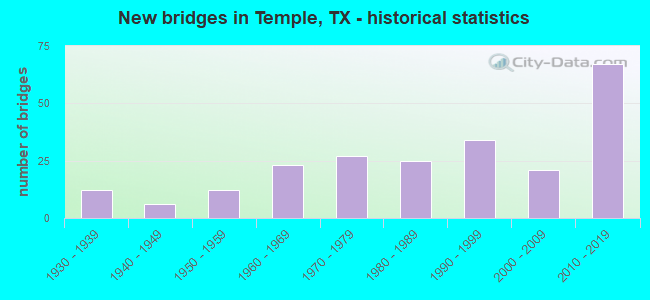
- New bridges - historical statistics
- 121930-1939
- 61940-1949
- 121950-1959
- 231960-1969
- 271970-1979
- 251980-1989
- 341990-1999
- 212000-2009
- 672010-2019

- Reconstructed bridges - Historical Statistics
- 31950-1959
- 21960-1969
- 61970-1979
- 61980-1989
- 41990-1999
- 22000-2009
- 22010-2019


- Bridge Condition - Deck
- 5.1%Very good
- 78.8%Good
- 16.1%Satisfactory

- Bridge Condition - Superstructure
- 22.0%Very good
- 58.5%Good
- 18.6%Satisfactory
- 0.8%Fair

- Bridge Condition - Substructure
- 13.6%Very good
- 56.8%Good
- 22.9%Satisfactory
- 6.8%Fair

- Bridge Condition - Channel
- 3.9%Very good
- 35.2%Good
- 46.1%Satisfactory
- 14.8%Fair

- Bridge Condition - Culverts
- 2.9%Very good
- 49.3%Good
- 43.5%Satisfactory
- 4.3%Fair
Find on map >> Show street view
Structure Number: 90140032001084, Location: 2.40 MI NW OF FM 93 (Lat: 31.055217, Lng: -97.330872), Route carried "under" structure: State highway 95, Year Built: 1985, Structure Length: 0. m, Average Daily Traffic: 6,390 (year 2015), Truck Traffic: 6%, Features Intersected: SH 95, Facility Carried by Structure: US 190
Minimum Vertical Clearance: 5.13m (16.83ft), Kilometerpoint: 21.787, Lanes on structure: 4, Lanes under structure: 3, Material/Design: Prestressed concrete continuous, Design/Construction: Stringer/Multi-beam, Length of Maximum Span: 36.6m (120.1ft)
Structure Number: 90140032005086, Location: 0.60 MI SE OF IH 35, Route carried "under" structure: City street , Year Built: 1985, Structure Length: 0. m, Average Daily Traffic: 53 (year 2016), Features Intersected: BNSF RR & OLD TROY RD, Facility Carried by Structure: LP 363
Minimum Vertical Clearance: 10.77m (35.33ft), Kilometerpoint: 0.805, Lanes on structure: 2, Lanes under structure: 2, Material/Design: Prestressed concrete continuous, Design/Construction: Stringer/Multi-beam, Length of Maximum Span: 24.4m (80.1ft)
Minimum Vertical Clearance: 10.77m (35.33ft), Kilometerpoint: 0.805, Lanes on structure: 2, Lanes under structure: 2, Material/Design: Prestressed concrete continuous, Design/Construction: Stringer/Multi-beam, Length of Maximum Span: 24.4m (80.1ft)
Find on map >> Show street view
Structure Number: 9014003200509, Location: 0.50 MI S OF SH 53 (Lat: 31.081708, Lng: -97.312900), Route carried "under" structure: State highway 363, Year Built: 1991, Structure Length: 0. m, Average Daily Traffic: 8,950 (year 2015), Truck Traffic: 4%, Features Intersected: LP 363, Facility Carried by Structure: LITTLE FLOCK RD
Minimum Vertical Clearance: 5.18m (16.99ft), Kilometerpoint: 39.328, Lanes on structure: 2, Lanes under structure: 4, Material/Design: Prestressed concrete, Design/Construction: Stringer/Multi-beam, Length of Maximum Span: 33.5m (109.9ft)
Structure Number: 90140032006403, Location: 2.20 MI NE OF SH 36, Route carried "under" structure: City street , Year Built: 2014, Structure Length: 0. m, Average Daily Traffic: 1,000 (year 2016), Truck Traffic: 25%, Features Intersected: WENDLAND RD, Facility Carried by Structure: LP 363 NB
Minimum Vertical Clearance: 5.21m (17.09ft), Material/Design: Prestressed concrete, Design/Construction: Stringer/Multi-beam, Length of Maximum Span: 32.0m (105.0ft)
Minimum Vertical Clearance: 5.21m (17.09ft), Material/Design: Prestressed concrete, Design/Construction: Stringer/Multi-beam, Length of Maximum Span: 32.0m (105.0ft)
Structure Number: 90140032006404, Location: 2.20 MI NE OF SH 36, Route carried "under" structure: City street , Year Built: 2014, Structure Length: 0. m, Average Daily Traffic: 1,000 (year 2016), Truck Traffic: 25%, Features Intersected: WENDLAND RD, Facility Carried by Structure: LP 363 SB
Minimum Vertical Clearance: 5.87m (19.26ft), Kilometerpoint: 0.000, Material/Design: Prestressed concrete, Design/Construction: Stringer/Multi-beam, Length of Maximum Span: 32.0m (105.0ft)
Minimum Vertical Clearance: 5.87m (19.26ft), Kilometerpoint: 0.000, Material/Design: Prestressed concrete, Design/Construction: Stringer/Multi-beam, Length of Maximum Span: 32.0m (105.0ft)
Find on map >> Show street view
Structure Number: 90140039804043, Location: 1.55 MI E OF FM 2271 (Lat: 31.121283, Lng: -97.443575), Route carried "under" structure: State highway 317, Year Built: 2010, Structure Length: 0. m, Average Daily Traffic: 18,570 (year 2015), Truck Traffic: 13%, Features Intersected: SH 317, Facility Carried by Structure: FM 2305
Minimum Vertical Clearance: 5.21m (17.09ft), Kilometerpoint: 1.492, Lanes on structure: 5, Lanes under structure: 6, Material/Design: Prestressed concrete, Design/Construction: Stringer/Multi-beam, Length of Maximum Span: 39.6m (129.9ft)