Bridge Statistics for Suffolk, Virginia (VA)
Condition, Traffic, Stress, Structural Evaluation, Project Costs
- National Bridge Inventory (NBI) Statistics
- 173Number of bridges
- 3,455ft / 1,053mTotal length
- $12,205,000Total costs
- 1,764,133Total average daily traffic
- 103,996Total average daily truck traffic
- National Bridge Inventory (NBI) Registered Bridges for Suffolk
- No street view available for this location
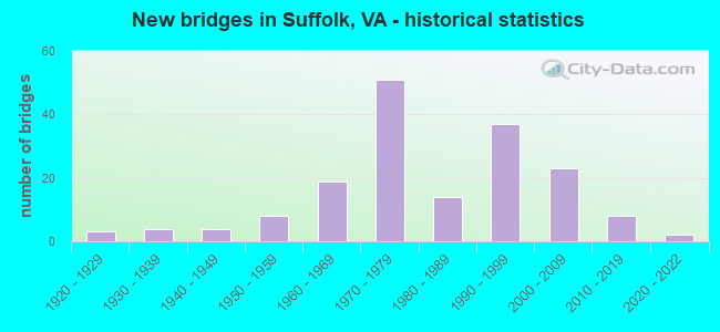
- New bridges - historical statistics
- 31920-1929
- 41930-1939
- 41940-1949
- 81950-1959
- 191960-1969
- 511970-1979
- 141980-1989
- 371990-1999
- 232000-2009
- 82010-2019
- 22020-2022

- Reconstructed bridges - Historical Statistics
- 11990-1999
- 02000-2009
- 12010-2019


- Bridge Condition - Deck
- 4.6%Excellent
- 27.8%Very good
- 42.6%Good
- 23.1%Satisfactory
- 1.9%Fair
- 0.9%Poor

- Bridge Condition - Superstructure
- 8.3%Excellent
- 23.1%Very good
- 31.5%Good
- 28.7%Satisfactory
- 6.5%Fair
- 1.9%Poor
- 0.9%Serious

- Bridge Condition - Substructure
- 6.5%Very good
- 23.1%Good
- 39.8%Satisfactory
- 28.7%Fair
- 1.9%Poor

- Bridge Condition - Channel
- 10.5%Very good
- 26.7%Good
- 31.4%Satisfactory
- 27.9%Fair
- 3.5%Poor

- Bridge Condition - Culverts
- 23.1%Good
- 46.2%Satisfactory
- 26.9%Fair
- 3.8%Poor
Find on map >> Show street view
Structure Number: 27256, Location: 0.4 MI. TO RTE. 645 WEST (Lat: 36.726336, Lng: -76.632000), Route carried "on" structure: Ramp US 13, Year Built: 2002, Status: Open, Structure Length: 8.14m (26.71ft), Average Daily Traffic: 6,300 (year 2018), Truck Traffic: 14%, Average Future Daily Traffic: 16,000 (year 2028), Design Load: HS 20+Mod, Features Intersected: ROUTE 13 (LOOP H), Facility Carried by Structure: ROUTE 58
Minimum Vertical Clearance: 30+ m (98+ ft), Kilometerpoint: 0.000, Lanes on structure: 2, Lanes under structure: 4, Base Highway Network: Yes, Owner: City or Municipal Highway Agency, Approaching Roadway Width: 11.6m (38.1ft), Skew: 2 degrees, Material/Design: Steel, Design/Construction: Stringer/Multi-beam, Number Of Spans In Main Unit: 3, Length of Maximum Span: 38.1m (125.0ft), Curb-To-Curb Width: 11.4m (37.4ft), Out-to-Out Width: 12.4m (40.7ft)
Condition: Deck: Satisfactory, Superstructure: Good, Substructure: Good, Operating Rating: 49.5 metric tons, Method Used To Determine Operating Rating: Load and Resistance Factor (LRFR), Inventory Rating: 38.2 metric tons, Method Used To Determine Inventory Rating: Load and Resistance Factor (LRFR), Structural Evaluation: Better than present minimum criteria, Deck Geometry: Superior to present desirable criteria, Underclear: Equal to present minimum criteria, Approach Roadway Alignment: Equal to present desirable criteria, Designated Inspection Frequency: Every 24 months, Inspection Date: July 2020, Deck Structure Type: Concrete Cast-file-Place, Wearing Surface/Protective System: Wearing Surface: Monolithic Concrete
Find on map >> Show street view
Structure Number: 27625, Location: 0.43 MI.FR.INT.RTE. 1823 (Lat: 36.759889, Lng: -76.557653), Route carried "on" structure: County highway 642, Year Built: 2003, Status: Closed, Structure Length: 1.49m (4.89ft), Average Daily Traffic: 4,271 (year 2020), Truck Traffic: 4%, Average Future Daily Traffic: 5,113 (year 2040), Design Load: HS 20+Mod, Features Intersected: BREWERS CREEK, Facility Carried by Structure: WILROY RD.
Minimum Vertical Clearance: 30+ m (98+ ft), Kilometerpoint: 24.312, Lanes on structure: 2, Owner: City or Municipal Highway Agency, Approaching Roadway Width: 9.8m (32.2ft), Material/Design: Concrete, Design/Construction: Slab, Number Of Spans In Main Unit: 3, Length of Maximum Span: 4.9m (16.1ft), Curb-To-Curb Width: 7.9m (25.9ft), Out-to-Out Width: 7.9m (25.9ft)
Condition: Deck: Satisfactory, Superstructure: Satisfactory, Substructure: Fair, Channel: Fair, Operating Rating: 59.3 metric tons, Method Used To Determine Operating Rating: Load and Resistance Factor (LRFR), Inventory Rating: 45.8 metric tons, Method Used To Determine Inventory Rating: Load and Resistance Factor (LRFR), Structural Evaluation: Somewhat better than minimum adequacy, Deck Geometry: High priority of corrective action, Waterway Adequacy: Better than present minimum criteria, Approach Roadway Alignment: Equal to present desirable criteria, Length Of Structure Improvement: 1.25m (4.10ft), Designated Inspection Frequency: Every 24 months, Inspection Date: September 2019, Bridge Improvement Cost: $65,000, Roadway Improvement Cost: $10,000, Total Project Cost: $75,000 ( Estimate for 2021), Deck Structure Type: Concrete Cast-file-Place, Wearing Surface/Protective System: Wearing Surface: Monolithic Concrete
Find on map >> Show street view
Structure Number: 28594, Location: 0.25 Mi from College Dr. (Lat: 36.865381, Lng: -76.427111), Route carried "on" structure: US 17, Year Built: 2009, Status: Open, Structure Length: 3.14m (10.30ft), Average Daily Traffic: 23,085 (year 2020), Truck Traffic: 1%, Average Future Daily Traffic: 25,394 (year 2040), Design Load: HS 20+Mod, Features Intersected: COMMONWEALTH RAILWAY
Minimum Vertical Clearance: 30+ m (98+ ft), Kilometerpoint: 0.000, Lanes on structure: 5, Base Highway Network: Yes, Owner: City or Municipal Highway Agency, Approaching Roadway Width: 24.1m (79.1ft), Skew: 14 degrees, Material/Design: Prestressed concrete, Design/Construction: Stringer/Multi-beam, Number Of Spans In Main Unit: 1, Length of Maximum Span: 31.4m (103.0ft), Curb or Sidewalk Widths: Left: 3.0m (9.8ft), Right: 0.0m, Curb-To-Curb Width: 25.0m (82.0ft), Out-to-Out Width: 35.5m (116.5ft)
Condition: Deck: Good, Superstructure: Very good, Substructure: Very good, Operating Rating: 78.9 metric tons, Method Used To Determine Operating Rating: Load and Resistance Factor (LRFR), Inventory Rating: 49.0 metric tons, Method Used To Determine Inventory Rating: Load and Resistance Factor (LRFR), Structural Evaluation: Equal to present desirable criteria, Deck Geometry: Superior to present desirable criteria, Underclear: Superior to present desirable criteria, Approach Roadway Alignment: Better than present minimum criteria, Designated Inspection Frequency: Every 24 months, Inspection Date: March 2020, Deck Structure Type: Concrete Cast-file-Place, Wearing Surface/Protective System: Deck Protection: Epoxy Coated Reinforcing
Find on map >> Show street view
Structure Number: 29212, Location: 0.02 TO ISLE OF WIGHT CO. (Lat: 36.684581, Lng: -76.841339), Route carried "on" structure: County highway 641, Year Built: 2009, Status: Open, Structure Length: 0.94m (3.08ft), Average Daily Traffic: 450 (year 2020), Average Future Daily Traffic: 495 (year 2040), Design Load: HS 20+Mod, Features Intersected: Kingsale Swamp, Facility Carried by Structure: Harvest Drive
Minimum Vertical Clearance: 30+ m (98+ ft), Kilometerpoint: 3.685, Lanes on structure: 2, Owner: City or Municipal Highway Agency, Approaching Roadway Width: 7.6m (24.9ft), Material/Design: Concrete, Design/Construction: Culvert, Number Of Spans In Main Unit: 3, Length of Maximum Span: 3.0m (9.8ft)
Condition: Channel: Good, Culverts: Satisfactory, Operating Rating: 40.6 metric tons, Method Used To Determine Operating Rating: Load Factor (LF), Inventory Rating: 24.2 metric tons, Method Used To Determine Inventory Rating: Load Factor (LF), Structural Evaluation: Equal to present minimum criteria, Waterway Adequacy: Better than present minimum criteria, Approach Roadway Alignment: Equal to present minimum criteria, Designated Inspection Frequency: Every 24 months, Inspection Date: January 2022
Find on map >> Show street view
Structure Number: 29441, Location: 0.2 to 745 / 2.1 to 666 (Lat: 36.572578, Lng: -76.856800), Route carried "on" structure: County highway 667, Year Built: 2010, Status: Open, Structure Length: 0.87m (2.85ft), Average Daily Traffic: 131 (year 2002), Average Future Daily Traffic: 177 (year 2040), Design Load: HS 20, Features Intersected: March Swamp, Facility Carried by Structure: Corinth Chapel Roa
Minimum Vertical Clearance: 30+ m (98+ ft), Kilometerpoint: 2.092, Lanes on structure: 2, Owner: City or Municipal Highway Agency, Approaching Roadway Width: 7.3m (24.0ft), Material/Design: Concrete, Design/Construction: Culvert, Number Of Spans In Main Unit: 3, Length of Maximum Span: 2.4m (7.9ft)
Condition: Channel: Good, Culverts: Good, Operating Rating: 33.5 metric tons, Method Used To Determine Operating Rating: Load Factor (LF), Inventory Rating: 20.0 metric tons, Method Used To Determine Inventory Rating: Load Factor (LF), Structural Evaluation: Somewhat better than minimum adequacy, Waterway Adequacy: Equal to present desirable criteria, Approach Roadway Alignment: Equal to present desirable criteria, Designated Inspection Frequency: Every 24 months, Inspection Date: April 2020
Find on map >> Show street view
Structure Number: 3057, Location: 0.08 Clrcrk/0.16 Prospect (Lat: 36.753039, Lng: -76.556606), Route carried "on" structure: City street , Year Built: 2006, Status: Open, Structure Length: 4.51m (14.80ft), Average Daily Traffic: 300 (year 2015), Average Future Daily Traffic: 500 (year 2035), Design Load: HS 20+Mod, Features Intersected: BR NANSEMOND RIVER, Facility Carried by Structure: REDGATE DRIVE
Minimum Vertical Clearance: 30+ m (98+ ft), Kilometerpoint: 0.000, Lanes on structure: 2, Owner: City or Municipal Highway Agency, Approaching Roadway Width: 11.0m (36.1ft), Material/Design: Prestressed concrete, Design/Construction: Box Beam or Girders - Multiple, Number Of Spans In Main Unit: 3, Length of Maximum Span: 15.2m (49.9ft), Curb or Sidewalk Widths: Left: 1.5m (4.9ft), Right: 1.5m (4.9ft), Curb-To-Curb Width: 11.0m (36.1ft), Out-to-Out Width: 16.5m (54.1ft)
Condition: Deck: Good, Superstructure: Good, Substructure: Good, Channel: Very good, Operating Rating: 80.1 metric tons, Method Used To Determine Operating Rating: Load and Resistance Factor (LRFR), Inventory Rating: 54.2 metric tons, Method Used To Determine Inventory Rating: Load and Resistance Factor (LRFR), Structural Evaluation: Better than present minimum criteria, Deck Geometry: Equal to present desirable criteria, Waterway Adequacy: Equal to present desirable criteria, Approach Roadway Alignment: Equal to present desirable criteria, Designated Inspection Frequency: Every 24 months, Inspection Date: Febuary 2021, Deck Structure Type: Concrete Precast Panels, Wearing Surface/Protective System: Wearing Surface: Bituminous, Membrane: Epoxy
Find on map >> Show street view
Structure Number: 30571, Location: 0.01 to NC / 0.08 to 668 (Lat: 36.551006, Lng: -76.781447), Route carried "on" structure: County highway 669, Year Built: 2015, Status: Open, Structure Length: 1.33m (4.36ft), Average Daily Traffic: 99 (year 2002), Truck Traffic: 1%, Average Future Daily Traffic: 174 (year 2040), Design Load: HS 20, Features Intersected: MILL SWAMP, Facility Carried by Structure: ROBBIE ROAD
Minimum Vertical Clearance: 30+ m (98+ ft), Kilometerpoint: 1.287, Lanes on structure: 2, Owner: City or Municipal Highway Agency, Approaching Roadway Width: 6.2m (20.3ft), Skew: 4 degrees, Material/Design: Concrete, Design/Construction: Frame, Number Of Spans In Main Unit: 2, Length of Maximum Span: 4.6m (15.1ft), Curb-To-Curb Width: 7.1m (23.3ft), Out-to-Out Width: 8.5m (27.9ft)
Condition: Deck: Good, Superstructure: Good, Substructure: Good, Channel: Good, Operating Rating: 50.6 metric tons, Method Used To Determine Operating Rating: Load and Resistance Factor (LRFR), Inventory Rating: 39.2 metric tons, Method Used To Determine Inventory Rating: Load and Resistance Factor (LRFR), Structural Evaluation: Better than present minimum criteria, Deck Geometry: Somewhat better than minimum adequacy, Waterway Adequacy: Better than present minimum criteria, Approach Roadway Alignment: Equal to present desirable criteria, Designated Inspection Frequency: Every 24 months, Inspection Date: June 2021, Deck Structure Type: Concrete Cast-file-Place, Wearing Surface/Protective System: Wearing Surface: Bituminous, Membrane: Epoxy, Deck Protection: Other Coated Reinforcing
Find on map >> Show street view
Structure Number: 30685, Location: .36 mi to Bainbridge Road (Lat: 36.750947, Lng: -76.780028), Route carried "on" structure: US 17, Year Built: 2013, Status: Open, Structure Length: 1.04m (3.41ft), Average Daily Traffic: 25,320 (year 2020), Truck Traffic: 5%, Average Future Daily Traffic: 27,852 (year 2040), Features Intersected: Mains Creek Culvert
Minimum Vertical Clearance: 30+ m (98+ ft), Kilometerpoint: 0.000, Lanes on structure: 4, Base Highway Network: Yes, Owner: City or Municipal Highway Agency, Approaching Roadway Width: 24.4m (80.1ft), Skew: 14 degrees, Material/Design: Concrete, Design/Construction: Culvert, Number Of Spans In Main Unit: 3, Length of Maximum Span: 1.8m (5.9ft)
Condition: Channel: Good, Culverts: Good, Operating Rating: 90.0 metric tons, Method Used To Determine Operating Rating: Load and Resistance Factor (LRFR), Inventory Rating: 69.4 metric tons, Method Used To Determine Inventory Rating: Load and Resistance Factor (LRFR), Structural Evaluation: Better than present minimum criteria, Waterway Adequacy: Equal to present desirable criteria, Approach Roadway Alignment: Equal to present desirable criteria, Designated Inspection Frequency: Every 24 months, Inspection Date: March 2021
Find on map >> Show street view
Structure Number: 30826, Location: .15 Fr 671/1.65 To 616 (Lat: 36.594939, Lng: -76.737111), Route carried "on" structure: County highway 643, Year Built: 2017, Status: Open, Structure Length: 1.65m (5.41ft), Average Daily Traffic: 175 (year 2002), Average Future Daily Traffic: 208 (year 2040), Design Load: HL 93, Features Intersected: SPIVEY SWAMP, Facility Carried by Structure: Arthur Drive
Minimum Vertical Clearance: 30+ m (98+ ft), Kilometerpoint: 0.000, Lanes on structure: 2, Owner: City or Municipal Highway Agency, Approaching Roadway Width: 7.3m (24.0ft), Material/Design: Concrete, Design/Construction: Frame, Number Of Spans In Main Unit: 1, Length of Maximum Span: 16.5m (54.1ft), Curb-To-Curb Width: 7.4m (24.3ft), Out-to-Out Width: 9.0m (29.5ft)
Condition: Deck: Good, Superstructure: Good, Substructure: Very good, Channel: Very good, Operating Rating: 44.3 metric tons, Method Used To Determine Operating Rating: Load and Resistance Factor (LRFR), Inventory Rating: 34.2 metric tons, Method Used To Determine Inventory Rating: Load and Resistance Factor (LRFR), Structural Evaluation: Better than present minimum criteria, Deck Geometry: Somewhat better than minimum adequacy, Waterway Adequacy: Better than present minimum criteria, Approach Roadway Alignment: Equal to present desirable criteria, Designated Inspection Frequency: Every 24 months, Inspection Date: March 2021, Wearing Surface/Protective System: Wearing Surface: Bituminous
Find on map >> Show street view
Structure Number: 3098, Location: 1.10 MI.FR.INT.RTE. 337 (Lat: 36.774106, Lng: -76.543717), Route carried "on" structure: County highway 642, Year Built: 2017, Status: Open, Structure Length: 0.77m (2.53ft), Average Daily Traffic: 8,343 (year 2020), Truck Traffic: 6%, Average Future Daily Traffic: 11,680 (year 2040), Design Load: HS 20+Mod, Features Intersected: MAGNOLIA CREEK, Facility Carried by Structure: WILROY RD.
Minimum Vertical Clearance: 30+ m (98+ ft), Kilometerpoint: 26.372, Lanes on structure: 2, Owner: City or Municipal Highway Agency, Approaching Roadway Width: 6.7m (22.0ft), Skew: 3 degrees, Material/Design: Aluminum, Iron, Design/Construction: Culvert, Number Of Spans In Main Unit: 1, Length of Maximum Span: 7.7m (25.3ft), Curb-To-Curb Width: 6.7m (22.0ft), Out-to-Out Width: 13.8m (45.3ft)
Condition: Channel: Very good, Culverts: Good, Operating Rating: 91.7 metric tons, Method Used To Determine Operating Rating: Load and Resistance Factor (LRFR), Inventory Rating: 70.8 metric tons, Method Used To Determine Inventory Rating: Load and Resistance Factor (LRFR), Structural Evaluation: Better than present minimum criteria, Deck Geometry: High priority of replacement, Waterway Adequacy: Better than present minimum criteria, Approach Roadway Alignment: Better than present minimum criteria, Designated Inspection Frequency: Every 24 months, Inspection Date: June 2021, Wearing Surface/Protective System: Wearing Surface: Bituminous
Find on map >> Show street view
Structure Number: 31169, Location: 0.25 TO 632 / 0.25 TO 644 (Lat: 36.751789, Lng: -76.724592), Route carried "on" structure: County highway 608, Year Built: 2019, Status: Open, Structure Length: 0.91m (2.99ft), Average Daily Traffic: 271 (year 2014), Average Future Daily Traffic: 356 (year 2035), Design Load: HS 20+Mod, Features Intersected: COHOON CREEK, Facility Carried by Structure: SIMONS DRIVE
Minimum Vertical Clearance: 30+ m (98+ ft), Kilometerpoint: 3.298, Lanes on structure: 2, Owner: City or Municipal Highway Agency, Approaching Roadway Width: 7.0m (23.0ft), Material/Design: Steel, Design/Construction: Stringer/Multi-beam, Number Of Spans In Main Unit: 1, Length of Maximum Span: 9.1m (29.9ft), Curb-To-Curb Width: 5.8m (19.0ft), Out-to-Out Width: 6.1m (20.0ft)
Condition: Deck: Very good, Superstructure: Very good, Substructure: Very good, Channel: Very good, Operating Rating: 62.0 metric tons, Method Used To Determine Operating Rating: Load and Resistance Factor (LRFR), Inventory Rating: 47.8 metric tons, Method Used To Determine Inventory Rating: Load and Resistance Factor (LRFR), Structural Evaluation: Equal to present desirable criteria, Deck Geometry: High priority of corrective action, Approach Roadway Alignment: Equal to present desirable criteria, Length Of Structure Improvement: 0.91m (2.99ft), Designated Inspection Frequency: Every 24 months, Inspection Date: March 2021, Bridge Improvement Cost: $46,000, Roadway Improvement Cost: $5,000, Total Project Cost: $69,000 ( Estimate for 2017), Deck Structure Type: Wood or Timber, Wearing Surface/Protective System: Wearing Surface: Gravel
Find on map >> Show street view
Structure Number: 31288, Location: 0.50 TO 643 / 0.10 TO 653 (Lat: 36.617717, Lng: -76.737544), Route carried "on" structure: County highway 616, Year Built: 2020, Status: Open, Structure Length: 2.77m (9.09ft), Average Daily Traffic: 528 (year 2018), Truck Traffic: 3%, Average Future Daily Traffic: 690 (year 2035), Design Load: HS 20+Mod, Features Intersected: Jones Swamp, Facility Carried by Structure: Mineral Springs Rd
Minimum Vertical Clearance: 30+ m (98+ ft), Kilometerpoint: 15.060, Lanes on structure: 2, Owner: City or Municipal Highway Agency, Approaching Roadway Width: 7.9m (25.9ft), Material/Design: Steel, Design/Construction: Stringer/Multi-beam, Number Of Spans In Main Unit: 3, Length of Maximum Span: 9.1m (29.9ft), Curb-To-Curb Width: 6.5m (21.3ft), Out-to-Out Width: 6.8m (22.3ft)
Condition: Deck: Very good, Superstructure: Very good, Substructure: Very good, Channel: Very good, Operating Rating: 62.7 metric tons, Method Used To Determine Operating Rating: Load and Resistance Factor (LRFR), Inventory Rating: 48.4 metric tons, Method Used To Determine Inventory Rating: Load and Resistance Factor (LRFR), Structural Evaluation: Equal to present desirable criteria, Deck Geometry: High priority of corrective action, Approach Roadway Alignment: Equal to present minimum criteria, Length Of Structure Improvement: 3.05m (10.01ft), Designated Inspection Frequency: Every 24 months, Inspection Date: January 2022, Bridge Improvement Cost: $154,000, Roadway Improvement Cost: $15,000, Total Project Cost: $231,000 ( Estimate for 2018), Deck Structure Type: Wood or Timber, Wearing Surface/Protective System: Wearing Surface: Gravel
Find on map >> Show street view
Structure Number: 31289, Location: 0.15 FR 680_/ 0.85 TO 612 (Lat: 36.648269, Lng: -76.770294), Route carried "on" structure: County highway 661, Year Built: 2019, Status: Open, Structure Length: 1.65m (5.41ft), Average Daily Traffic: 158 (year 2014), Average Future Daily Traffic: 208 (year 2035), Design Load: HS 20+Mod, Features Intersected: Chapel Swamp, Facility Carried by Structure: Southwestern Blvd.
Minimum Vertical Clearance: 30+ m (98+ ft), Kilometerpoint: 9.574, Lanes on structure: 2, Owner: City or Municipal Highway Agency, Approaching Roadway Width: 7.1m (23.3ft), Material/Design: Prestressed concrete, Design/Construction: Box Beam or Girders - Multiple, Number Of Spans In Main Unit: 1, Length of Maximum Span: 14.6m (47.9ft), Curb-To-Curb Width: 7.1m (23.3ft), Out-to-Out Width: 7.3m (24.0ft)
Condition: Deck: Very good, Superstructure: Very good, Substructure: Very good, Channel: Very good, Operating Rating: 63.1 metric tons, Method Used To Determine Operating Rating: Load and Resistance Factor (LRFR), Inventory Rating: 48.7 metric tons, Method Used To Determine Inventory Rating: Load and Resistance Factor (LRFR), Structural Evaluation: Equal to present desirable criteria, Deck Geometry: Meets minimum limits, Waterway Adequacy: Better than present minimum criteria, Approach Roadway Alignment: Equal to present desirable criteria, Designated Inspection Frequency: Every 24 months, Inspection Date: April 2021, Deck Structure Type: Other, Wearing Surface/Protective System: Wearing Surface: Bituminous, Membrane: Epoxy, Deck Protection: Other Coated Reinforcing
Find on map >> Show street view
Structure Number: 3129, Location: 0.40 FR 642 / 0.90 TO 604 (Lat: 36.663444, Lng: -76.564678), Route carried "on" structure: County highway 674, Year Built: 2019, Status: Open, Structure Length: 1.65m (5.41ft), Average Daily Traffic: 107 (year 2014), Average Future Daily Traffic: 141 (year 2035), Design Load: HS 20+Mod, Features Intersected: WASHINGTON DITCH, Facility Carried by Structure: BADGER ROAD
Minimum Vertical Clearance: 30+ m (98+ ft), Kilometerpoint: 4.505, Lanes on structure: 2, Owner: City or Municipal Highway Agency, Approaching Roadway Width: 7.1m (23.3ft), Material/Design: Prestressed concrete, Design/Construction: Box Beam or Girders - Multiple, Number Of Spans In Main Unit: 1, Length of Maximum Span: 14.6m (47.9ft), Curb-To-Curb Width: 7.1m (23.3ft), Out-to-Out Width: 7.3m (24.0ft)
Condition: Deck: Very good, Superstructure: Very good, Substructure: Very good, Channel: Very good, Operating Rating: 64.5 metric tons, Method Used To Determine Operating Rating: Load and Resistance Factor (LRFR), Inventory Rating: 49.8 metric tons, Method Used To Determine Inventory Rating: Load and Resistance Factor (LRFR), Structural Evaluation: Equal to present desirable criteria, Deck Geometry: Meets minimum limits, Waterway Adequacy: Better than present minimum criteria, Approach Roadway Alignment: Equal to present desirable criteria, Designated Inspection Frequency: Every 24 months, Inspection Date: May 2021, Deck Structure Type: Other, Wearing Surface/Protective System: Wearing Surface: Bituminous, Membrane: Epoxy
Find on map >> Show street view
Structure Number: 31431, Location: 0.60 TO 632 / 0.70 TO 644 (Lat: 36.759889, Lng: -76.704658), Route carried "on" structure: County highway 607, Year Built: 2020, Status: Open, Structure Length: 1.25m (4.10ft), Average Daily Traffic: 271 (year 2014), Average Future Daily Traffic: 356 (year 2035), Design Load: HS 20+Mod, Features Intersected: Cohoon Creek, Facility Carried by Structure: Old Mill Road
Minimum Vertical Clearance: 30+ m (98+ ft), Kilometerpoint: 4.183, Lanes on structure: 2, Owner: City or Municipal Highway Agency, Approaching Roadway Width: 9.1m (29.9ft), Material/Design: Prestressed concrete, Design/Construction: Slab, Number Of Spans In Main Unit: 1, Length of Maximum Span: 12.5m (41.0ft), Curb-To-Curb Width: 9.2m (30.2ft), Out-to-Out Width: 9.8m (32.2ft)
Condition: Deck: Excellent, Superstructure: Excellent, Substructure: Very good, Channel: Very good, Operating Rating: 70.6 metric tons, Method Used To Determine Operating Rating: Load and Resistance Factor (LRFR), Inventory Rating: 53.6 metric tons, Method Used To Determine Inventory Rating: Load and Resistance Factor (LRFR), Structural Evaluation: Equal to present desirable criteria, Deck Geometry: Equal to present minimum criteria, Approach Roadway Alignment: Better than present minimum criteria, Length Of Structure Improvement: 1.22m (4.00ft), Designated Inspection Frequency: Every 24 months, Inspection Date: July 2020, Bridge Improvement Cost: $91,000, Roadway Improvement Cost: $25,000, Total Project Cost: $131,000, Deck Structure Type: Concrete Precast Panels, Wearing Surface/Protective System: Wearing Surface: Bituminous
Find on map >> Show street view
Structure Number: 21996, Location: 0.50 Mi Fr Int Rte 135 (Lat: 36.897169, Lng: -76.425892), Route carried "under" structure: Interstate 664, Year Built: 1988, Structure Length: 0. m, Average Daily Traffic: 54,603 (year 2008), Truck Traffic: 2%, Features Intersected: IS 664, Facility Carried by Structure: Armstead Road
Minimum Vertical Clearance: 5.69m (18.67ft), Kilometerpoint: 18.005, Lanes on structure: 2, Lanes under structure: 5, Material/Design: Steel continuous, Design/Construction: Stringer/Multi-beam, Length of Maximum Span: 25.9m (85.0ft)
Find on map >> Show street view
Structure Number: 22004, Location: 0.80 MI.FR.INT.RTE. 460 (Lat: 36.767333, Lng: -76.585664), Route carried "under" structure: Bypass US 58, Year Built: 1973, Structure Length: 0. m, Average Daily Traffic: 26,000 (year 1996), Features Intersected: US 58 & 460 BYPASS, Facility Carried by Structure: SR 10 GODWIN BLVD.
Minimum Vertical Clearance: 5.00m (16.40ft), Kilometerpoint: 12.051, Lanes on structure: 5, Lanes under structure: 5, Material/Design: Steel continuous, Design/Construction: Stringer/Multi-beam, Length of Maximum Span: 27.4m (89.9ft)
Find on map >> Show street view
Structure Number: 22016, Location: 0.40 MI.FR.RTE.58 & 460 (Lat: 36.773317, Lng: -76.603233), Route carried "under" structure: Bypass US 58, Year Built: 1973, Structure Length: 0. m, Average Daily Traffic: 19,000 (year 1996), Features Intersected: RTE. 58 & 460 BYPASS, Facility Carried by Structure: S.B.L. RTE. 13
Minimum Vertical Clearance: 5.15m (16.90ft), Kilometerpoint: 5.808, Lanes on structure: 2, Lanes under structure: 4, Material/Design: Steel, Design/Construction: Stringer/Multi-beam, Length of Maximum Span: 38.1m (125.0ft)
Find on map >> Show street view
Structure Number: 22018, Location: 0.10 TO 337 /0.23 TO 32 (Lat: 36.725639, Lng: -76.585450), Route carried "under" structure: US , Year Built: 1978, Structure Length: 0. m, Average Daily Traffic: 6,130 (year 1994), Features Intersected: HALL AV;N&W RR & POPL ST, Facility Carried by Structure: MAIN STREET
Minimum Vertical Clearance: 6.53m (21.42ft), Kilometerpoint: 0.000, Lanes on structure: 4, Lanes under structure: 4, Material/Design: Steel continuous, Design/Construction: Stringer/Multi-beam, Length of Maximum Span: 36.3m (119.1ft)
Find on map >> Show street view
Structure Number: 22043, Location: 3.0 MI.FR.INT.RTE. 10 (Lat: 36.761139, Lng: -76.535458), Route carried "under" structure: State highway 337, Year Built: 1973, Structure Length: 0. m, Average Daily Traffic: 4,000 (year 1996), Features Intersected: SR 337 NANSEMOND PKW, Facility Carried by Structure: US 13 NBL & BYPASS
Minimum Vertical Clearance: 7.53m (24.70ft), Kilometerpoint: 0.000, Lanes on structure: 2, Lanes under structure: 2, Material/Design: Steel, Design/Construction: Stringer/Multi-beam, Length of Maximum Span: 36.9m (121.1ft)
Find on map >> Show street view
Structure Number: 22045, Location: 1.28 MI.FR.INT.RTE.13 WBL (Lat: 36.761375, Lng: -76.535233), Route carried "under" structure: State highway 337, Year Built: 1973, Structure Length: 0. m, Average Daily Traffic: 4,000 (year 1996), Features Intersected: SR 337 NANSEMOND PKWY., Facility Carried by Structure: US 13 SBL & BYPASS
Minimum Vertical Clearance: 7.48m (24.54ft), Kilometerpoint: 0.000, Lanes on structure: 2, Lanes under structure: 2, Material/Design: Steel, Design/Construction: Stringer/Multi-beam, Length of Maximum Span: 36.9m (121.1ft)
Find on map >> Show street view
Structure Number: 22049, Location: 1.84 MI.FR.INT.RTE. 10 (Lat: 36.764867, Lng: -76.553692), Route carried "under" structure: County highway 642, Year Built: 1973, Structure Length: 0. m, Average Daily Traffic: 7,301 (year 1995), Features Intersected: WILROY ROAD, Facility Carried by Structure: US 13 NBL & BYPASS
Minimum Vertical Clearance: 4.95m (16.24ft), Kilometerpoint: 0.000, Lanes on structure: 3, Lanes under structure: 4, Material/Design: Steel, Design/Construction: Stringer/Multi-beam, Length of Maximum Span: 29.0m (95.1ft)
Find on map >> Show street view
Structure Number: 22051, Location: 1.84 MI.TO.INT.RTE.10 (Lat: 36.765156, Lng: -76.553389), Route carried "under" structure: County highway 642, Year Built: 1973, Structure Length: 0. m, Average Daily Traffic: 7,301 (year 1995), Features Intersected: WILROY ROAD, Facility Carried by Structure: US 13 SBL & BYPASS
Minimum Vertical Clearance: 5.11m (16.77ft), Kilometerpoint: 0.000, Lanes on structure: 3, Lanes under structure: 4, Material/Design: Steel, Design/Construction: Stringer/Multi-beam, Length of Maximum Span: 29.0m (95.1ft)
Find on map >> Show street view
Structure Number: 22053, Location: 1.61 MI.FR.INT.RTE. 604 (Lat: 36.766897, Lng: -76.603608), Route carried "under" structure: US 460, Year Built: 1973, Structure Length: 0. m, Average Daily Traffic: 13,170 (year 1994), Features Intersected: US 460 (PRUDEN BLVD.), Facility Carried by Structure: US 13 NBL & BYPASS
Minimum Vertical Clearance: 5.18m (16.99ft), Kilometerpoint: 13.773, Lanes on structure: 3, Lanes under structure: 5, Material/Design: Prestressed concrete, Design/Construction: Stringer/Multi-beam, Length of Maximum Span: 21.0m (68.9ft)
Find on map >> Show street view
Structure Number: 22055, Location: 0.62 MI.FR.INT.RTE.58 BUS (Lat: 36.732208, Lng: -76.626744), Route carried "under" structure: County highway 639, Year Built: 1974, Structure Length: 0. m, Average Daily Traffic: 1,405 (year 1994), Features Intersected: RTE. 639 LAKE COHOON RD., Facility Carried by Structure: US 13 NBL & BYPASS
Minimum Vertical Clearance: 8.33m (27.33ft), Kilometerpoint: 0.000, Lanes on structure: 2, Lanes under structure: 2, Material/Design: Steel, Design/Construction: Stringer/Multi-beam, Length of Maximum Span: 21.9m (71.9ft)
Find on map >> Show street view
Structure Number: 22057, Location: 1.16 MI.FR.INT.RTE. 604 (Lat: 36.732358, Lng: -76.626983), Route carried "under" structure: County highway 639, Year Built: 1974, Structure Length: 0. m, Average Daily Traffic: 1,405 (year 1994), Features Intersected: RTE. 639 LAKE COHOON RD., Facility Carried by Structure: US 13 SBL & BYPASS
Minimum Vertical Clearance: 8.33m (27.33ft), Kilometerpoint: 0.000, Lanes on structure: 2, Lanes under structure: 2, Material/Design: Steel, Design/Construction: Stringer/Multi-beam, Length of Maximum Span: 21.9m (71.9ft)
Find on map >> Show street view
Structure Number: 22063, Location: 1.07 MI.FR.INT.RTE. 10 (Lat: 36.767044, Lng: -76.603911), Route carried "under" structure: US 460, Year Built: 1974, Structure Length: 0. m, Average Daily Traffic: 13,170 (year 1994), Features Intersected: US 460 (PRUDEN BLVD.), Facility Carried by Structure: US 13 SBL BYPASS
Minimum Vertical Clearance: 5.13m (16.83ft), Kilometerpoint: 13.773, Lanes on structure: 2, Lanes under structure: 4, Material/Design: Prestressed concrete, Design/Construction: Stringer/Multi-beam, Length of Maximum Span: 21.0m (68.9ft)
Find on map >> Show street view
Structure Number: 22068, Location: 0.97 MI.TO.INT.RTE. 189 (Lat: 36.683611, Lng: -76.771536), Route carried "under" structure: Business US 58, Year Built: 1976, Structure Length: 0. m, Average Daily Traffic: 4,760 (year 1994), Features Intersected: US 58 EBL BUSINESS
Minimum Vertical Clearance: 4.97m (16.31ft), Kilometerpoint: 24.746, Lanes on structure: 2, Lanes under structure: 1, Material/Design: Steel, Design/Construction: Stringer/Multi-beam, Length of Maximum Span: 22.3m (73.2ft)
Find on map >> Show street view
Structure Number: 22072, Location: 1.35 MI.TO INT.RTE. 660 (Lat: 36.678714, Lng: -76.773908), Route carried "under" structure: State highway 653, Year Built: 1976, Structure Length: 0. m, Average Daily Traffic: 515 (year 1994), Features Intersected: RTE. 653 (OLD DUTCH RD.), Facility Carried by Structure: US 58 EBL; BYPASS
Minimum Vertical Clearance: 4.82m (15.81ft), Kilometerpoint: 0.000, Lanes on structure: 2, Lanes under structure: 2, Material/Design: Steel, Design/Construction: Stringer/Multi-beam, Length of Maximum Span: 17.4m (57.1ft)
Find on map >> Show street view
Structure Number: 22074, Location: 1.35 MI.FR.INT.RTE. 660 (Lat: 36.679056, Lng: -76.774144), Route carried "under" structure: State highway 653, Year Built: 1976, Structure Length: 0. m, Average Daily Traffic: 515 (year 1994), Features Intersected: RTE. 653 (OLD DUTCH RD.), Facility Carried by Structure: US 58 WBL & BYPASS
Minimum Vertical Clearance: 4.82m (15.81ft), Kilometerpoint: 0.000, Lanes on structure: 2, Lanes under structure: 2, Material/Design: Steel, Design/Construction: Stringer/Multi-beam, Length of Maximum Span: 17.4m (57.1ft)
Find on map >> Show street view
Structure Number: 2208, Location: 0.03 Mi Fr Int Rte 17 (Lat: 36.867047, Lng: -76.422236), Route carried "under" structure: State highway 164, Year Built: 1991, Structure Length: 0. m, Average Daily Traffic: 23,000 (year 1996), Features Intersected: SR 164 & Commonwealth RR, Facility Carried by Structure: College Drive
Minimum Vertical Clearance: 7.54m (24.74ft), Kilometerpoint: 0.000, Lanes on structure: 6, Lanes under structure: 6, Material/Design: Steel continuous, Design/Construction: Stringer/Multi-beam, Length of Maximum Span: 38.1m (125.0ft)
Find on map >> Show street view
Structure Number: 22082, Location: 1.20 Mi Fr Int Rte 17 (Lat: 36.886897, Lng: -76.429072), Route carried "under" structure: Interstate 664, Year Built: 1991, Structure Length: 0. m, Average Daily Traffic: 27,000 (year 1996), Features Intersected: IS 664, Facility Carried by Structure: College Drive
Minimum Vertical Clearance: 5.31m (17.42ft), Kilometerpoint: 19.308, Lanes on structure: 6, Lanes under structure: 6, Material/Design: Steel continuous, Design/Construction: Stringer/Multi-beam, Length of Maximum Span: 43.3m (142.1ft)
Find on map >> Show street view
Structure Number: 221, Location: 0.70 MI.FR.RTE. 640 (Lat: 36.745961, Lng: -76.613850), Route carried "under" structure: US 13, Year Built: 1974, Structure Length: 0. m, Average Daily Traffic: 27,000 (year 1996), Features Intersected: RTE. 58 BYPASS, Facility Carried by Structure: PITCHKETTLE RD.
Minimum Vertical Clearance: 5.05m (16.57ft), Kilometerpoint: 16.380, Lanes on structure: 2, Lanes under structure: 4, Material/Design: Steel continuous, Design/Construction: Stringer/Multi-beam, Length of Maximum Span: 35.4m (116.1ft)
Find on map >> Show street view
Structure Number: 22119, Location: 0.30 MI.FR.INT.RTE. 635 (Lat: 36.763239, Lng: -76.607150), Route carried "under" structure: US 58, Year Built: 1974, Structure Length: 0. m, Average Daily Traffic: 26,000 (year 1996), Features Intersected: RTE. 58 BYPASS, Facility Carried by Structure: MURPHY'S MILL RD.
Minimum Vertical Clearance: 5.23m (17.16ft), Kilometerpoint: 5.310, Lanes on structure: 2, Lanes under structure: 4, Material/Design: Steel continuous, Design/Construction: Stringer/Multi-beam, Length of Maximum Span: 35.7m (117.1ft)
Find on map >> Show street view
Structure Number: 23086, Location: 1.10 Mi Fr Route 17 (Lat: 36.876269, Lng: -76.433639), Route carried "under" structure: Interstate 664, Year Built: 1991, Structure Length: 0. m, Average Daily Traffic: 57,076 (year 2008), Truck Traffic: 2%, Features Intersected: I-664, Facility Carried by Structure: Hampton Roads Pkwy
Minimum Vertical Clearance: 5.41m (17.75ft), Kilometerpoint: 20.402, Lanes on structure: 2, Lanes under structure: 6, Material/Design: Steel continuous, Design/Construction: Stringer/Multi-beam, Length of Maximum Span: 35.1m (115.2ft)
Find on map >> Show street view
Structure Number: 23087, Location: 0.60 Mi Fr Route 135 (Lat: 36.876417, Lng: -76.433619), Route carried "under" structure: Interstate 664, Year Built: 1991, Structure Length: 0. m, Average Daily Traffic: 57,076 (year 2008), Truck Traffic: 2%, Features Intersected: I-664, Facility Carried by Structure: Hampton Rd Pkwy WB
Minimum Vertical Clearance: 5.41m (17.75ft), Kilometerpoint: 20.402, Lanes on structure: 2, Lanes under structure: 6, Material/Design: Steel continuous, Design/Construction: Stringer/Multi-beam, Length of Maximum Span: 35.1m (115.2ft)
Find on map >> Show street view
Structure Number: 23091, Location: 0.10 Mi Fr Route 17 (Lat: 36.867636, Lng: -76.432422), Route carried "under" structure: Interstate 664, Year Built: 1991, Structure Length: 0. m, Average Daily Traffic: 29,782 (year 2018), Truck Traffic: 6%, Features Intersected: SR 164
Minimum Vertical Clearance: 30+ m (98+ ft), Kilometerpoint: 21.641, Lanes on structure: 3, Lanes under structure: 3, Material/Design: Steel continuous, Design/Construction: Stringer/Multi-beam, Length of Maximum Span: 33.8m (110.9ft)
Find on map >> Show street view
Structure Number: 23092, Location: 0.60 Mi Fr Route 658 (Lat: 36.867583, Lng: -76.432700), Route carried "under" structure: State highway 164, Year Built: 1991, Structure Length: 0. m, Average Daily Traffic: 23,000 (year 1996), Features Intersected: SR 164, Facility Carried by Structure: I-664 SBL
Minimum Vertical Clearance: 5.46m (17.91ft), Kilometerpoint: 0.000, Lanes on structure: 3, Lanes under structure: 5, Material/Design: Steel continuous, Design/Construction: Stringer/Multi-beam, Length of Maximum Span: 33.8m (110.9ft)
Find on map >> Show street view
Structure Number: 23093, Location: 0.40 Mi Fr I-664 (Lat: 36.867144, Lng: -76.435142), Route carried "under" structure: State highway 164, Year Built: 1991, Structure Length: 0. m, Average Daily Traffic: 17,822 (year 2008), Truck Traffic: 4%, Features Intersected: SR 164, Facility Carried by Structure: I-664 SBL Ramp
Minimum Vertical Clearance: 5.87m (19.26ft), Kilometerpoint: 0.998, Lanes on structure: 1, Lanes under structure: 5, Material/Design: Steel continuous, Design/Construction: Stringer/Multi-beam, Length of Maximum Span: 35.4m (116.1ft)
Find on map >> Show street view
Structure Number: 23095, Location: 3.2 Mi Fr Int SR 337 (Lat: 36.865664, Lng: -76.432097), Route carried "under" structure: Interstate 17, Year Built: 1991, Structure Length: 0. m, Average Daily Traffic: 23,000 (year 1996), Features Intersected: US17 & SR164 EBL Ramp, Facility Carried by Structure: IS 664 NBL
Minimum Vertical Clearance: 5.43m (17.81ft), Kilometerpoint: 0.000, Lanes on structure: 2, Lanes under structure: 5, Material/Design: Steel continuous, Design/Construction: Stringer/Multi-beam, Length of Maximum Span: 26.5m (86.9ft)
Find on map >> Show street view
Structure Number: 23095, Location: 3.2 Mi Fr Int SR 337 (Lat: 36.865664, Lng: -76.432097), Route carried "under" structure: Ramp Interstate 164, Year Built: 1991, Structure Length: 0. m, Average Daily Traffic: 23,000 (year 1996), Features Intersected: US17 & SR164 EBL Ramp, Facility Carried by Structure: IS 664 NBL
Minimum Vertical Clearance: 5.18m (16.99ft), Kilometerpoint: 0.000, Lanes on structure: 2, Lanes under structure: 5, Material/Design: Steel continuous, Design/Construction: Stringer/Multi-beam, Length of Maximum Span: 26.5m (86.9ft)
Find on map >> Show street view
Structure Number: 23096, Location: 0.8 Mi Fr Int Rte 658 (Lat: 36.865658, Lng: -76.432386), Route carried "under" structure: US 17, Year Built: 1991, Structure Length: 0. m, Average Daily Traffic: 20,000 (year 1996), Features Intersected: US 17 & SR 164 EBL Ramp, Facility Carried by Structure: IS 664 SBL
Minimum Vertical Clearance: 5.43m (17.81ft), Kilometerpoint: 0.000, Lanes on structure: 3, Lanes under structure: 6, Material/Design: Steel continuous, Design/Construction: Stringer/Multi-beam, Length of Maximum Span: 26.8m (87.9ft)
Find on map >> Show street view
Structure Number: 23096, Location: 0.8 Mi Fr Int Rte 658 (Lat: 36.865658, Lng: -76.432386), Route carried "under" structure: Ramp Interstate 164, Year Built: 1991, Structure Length: 0. m, Average Daily Traffic: 23,000 (year 1996), Features Intersected: US 17 & SR 164 EBL Ramp, Facility Carried by Structure: IS 664 SBL
Minimum Vertical Clearance: 5.39m (17.68ft), Kilometerpoint: 0.000, Lanes on structure: 3, Lanes under structure: 6, Material/Design: Steel continuous, Design/Construction: Stringer/Multi-beam, Length of Maximum Span: 26.8m (87.9ft)
Find on map >> Show street view
Structure Number: 23097, Location: 0.80 Mi To Int Rte 164 (Lat: 36.865064, Lng: -76.430286), Route carried "under" structure: US 17, Year Built: 1991, Structure Length: 0. m, Average Daily Traffic: 18,931 (year 2008), Truck Traffic: 1%, Features Intersected: US 17, Facility Carried by Structure: IS 664 NBL Ramp 9B
Minimum Vertical Clearance: 5.79m (19.00ft), Kilometerpoint: 54.078, Lanes on structure: 1, Lanes under structure: 4, Material/Design: Steel continuous, Design/Construction: Stringer/Multi-beam, Length of Maximum Span: 29.6m (97.1ft)
Find on map >> Show street view
Structure Number: 23098, Location: 0.3 Mi Fr Int Rte 17 (Lat: 36.863458, Lng: -76.440150), Route carried "under" structure: US 17, Year Built: 1991, Structure Length: 0. m, Average Daily Traffic: 2,000 (year 1994), Features Intersected: US 17, Facility Carried by Structure: SR 164 EBL
Minimum Vertical Clearance: 6.27m (20.57ft), Kilometerpoint: 0.000, Lanes on structure: 2, Lanes under structure: 3, Material/Design: Steel continuous, Design/Construction: Stringer/Multi-beam, Length of Maximum Span: 40.8m (133.9ft)
Find on map >> Show street view
Structure Number: 233, Location: 0.8 MI FR INT RTE 272 (Lat: 36.647172, Lng: -76.873250), Route carried "under" structure: US 58, Year Built: 1992, Structure Length: 0. m, Average Daily Traffic: 13,000 (year 1996), Features Intersected: RTE. 58 BYPASS, Facility Carried by Structure: GREAT MILL HIGHWAY
Minimum Vertical Clearance: 5.05m (16.57ft), Kilometerpoint: 0.000, Lanes on structure: 3, Lanes under structure: 5, Material/Design: Steel continuous, Design/Construction: Stringer/Multi-beam, Length of Maximum Span: 33.8m (110.9ft)
Find on map >> Show street view
Structure Number: 24841, Location: 0.25 TO 337 / 0.02 TO 58B (Lat: 36.733486, Lng: -76.592744), Route carried "under" structure: City street , Year Built: 1997, Structure Length: 0. m, Average Daily Traffic: 250 (year 2012), Features Intersected: Prentis St & CSX RAILWAY, Facility Carried by Structure: BROAD STREET
Minimum Vertical Clearance: 6.07m (19.91ft), Kilometerpoint: 0.000, Lanes on structure: 2, Lanes under structure: 2, Material/Design: Prestressed concrete, Design/Construction: Box Beam or Girders - Multiple, Length of Maximum Span: 21.0m (68.9ft)
Find on map >> Show street view
Structure Number: 25658, Location: 2.50 TO 58/0.00 TO 32BUS (Lat: 36.701100, Lng: -76.600806), Route carried "under" structure: US 13, Year Built: 2002, Structure Length: 0. m, Average Daily Traffic: 9,000 (year 2000), Truck Traffic: 10%, Features Intersected: ROUTE 32
Minimum Vertical Clearance: 5.28m (17.32ft), Kilometerpoint: 0.000, Lanes on structure: 1, Lanes under structure: 4, Material/Design: Steel, Design/Construction: Stringer/Multi-beam, Length of Maximum Span: 30.5m (100.1ft)
Find on map >> Show street view
Structure Number: 25667, Location: 2.50 MI. TO RTE. 32 (Lat: 36.726256, Lng: -76.632100), Route carried "under" structure: Bypass US 58, Year Built: 2002, Structure Length: 0. m, Average Daily Traffic: 12,000 (year 2000), Features Intersected: ROUTE 58, Facility Carried by Structure: ROUTE 13 SBL
Minimum Vertical Clearance: 5.31m (17.42ft), Kilometerpoint: 0.000, Lanes on structure: 2, Lanes under structure: 4, Material/Design: Steel, Design/Construction: Stringer/Multi-beam, Length of Maximum Span: 38.1m (125.0ft)
Find on map >> Show street view
Structure Number: 25668, Location: 0.10 MI. WEST TO 58 (Lat: 36.724394, Lng: -76.631083), Route carried "under" structure: County highway 688, Year Built: 2002, Structure Length: 0. m, Average Daily Traffic: 3,637 (year 2000), Features Intersected: TURLINGTON RD. (RT. 688), Facility Carried by Structure: ROUTE 13 NBL (BYP
Minimum Vertical Clearance: 5.46m (17.91ft), Kilometerpoint: 0.000, Lanes on structure: 2, Lanes under structure: 2, Material/Design: Steel, Design/Construction: Stringer/Multi-beam, Length of Maximum Span: 35.4m (116.1ft)
Find on map >> Show street view
Structure Number: 25669, Location: 0.20 MI. TO RTE. 58 BUS. (Lat: 36.724486, Lng: -76.630994), Route carried "under" structure: County highway 688, Year Built: 2002, Structure Length: 0. m, Average Daily Traffic: 3,637 (year 2000), Features Intersected: TURLINGTON RD. (RT. 688), Facility Carried by Structure: ROUTE 13 SBL (BYP)
Minimum Vertical Clearance: 5.26m (17.26ft), Kilometerpoint: 0.000, Lanes on structure: 2, Lanes under structure: 2, Material/Design: Steel, Design/Construction: Stringer/Multi-beam, Length of Maximum Span: 35.4m (116.1ft)
Find on map >> Show street view
Structure Number: 2567, Location: 0.10 TO 58_/ 2.40 TO 32 (Lat: 36.724303, Lng: -76.631183), Route carried "under" structure: County highway 688, Year Built: 2002, Structure Length: 0. m, Average Daily Traffic: 3,700 (year 2001), Features Intersected: TURLINGTON RD. (RT. 688), Facility Carried by Structure: RAMP TO RT. 13 SBL
Minimum Vertical Clearance: 5.16m (16.93ft), Kilometerpoint: 0.000, Lanes on structure: 1, Lanes under structure: 2, Material/Design: Steel, Design/Construction: Stringer/Multi-beam, Length of Maximum Span: 33.2m (108.9ft)
Find on map >> Show street view
Structure Number: 25671, Location: 2.60MI. W OF RTE 13/32 (Lat: 36.726392, Lng: -76.631444), Route carried "under" structure: Ramp US 13, Year Built: 2002, Structure Length: 0. m, Average Daily Traffic: 13,000 (year 2000), Truck Traffic: 10%, Features Intersected: ROUTE 58 BUS.
Minimum Vertical Clearance: 5.26m (17.26ft), Kilometerpoint: 0.000, Lanes on structure: 1, Lanes under structure: 3, Material/Design: Steel, Design/Construction: Stringer/Multi-beam, Length of Maximum Span: 30.5m (100.1ft)
Find on map >> Show street view
Structure Number: 27256, Location: 0.4 MI. TO RTE. 645 WEST (Lat: 36.726336, Lng: -76.632000), Route carried "under" structure: Bypass US 58, Year Built: 2002, Structure Length: 0. m, Average Daily Traffic: 12,000 (year 2000), Truck Traffic: 10%, Features Intersected: ROUTE 13 (LOOP H)
Minimum Vertical Clearance: 5.46m (17.91ft), Kilometerpoint: 0.000, Lanes on structure: 2, Lanes under structure: 4, Material/Design: Steel, Design/Construction: Stringer/Multi-beam, Length of Maximum Span: 38.1m (125.0ft)