Bridge Statistics for Spring Hill, Tennessee (TN)
Condition, Traffic, Stress, Structural Evaluation, Project Costs
- National Bridge Inventory (NBI) Statistics
- 76Number of bridges
- 633ft / 193mTotal length
- $23,589,000Total costs
- 1,266,506Total average daily traffic
- 158,516Total average daily truck traffic
- National Bridge Inventory (NBI) Registered Bridges for Spring Hill
- No street view available for this location
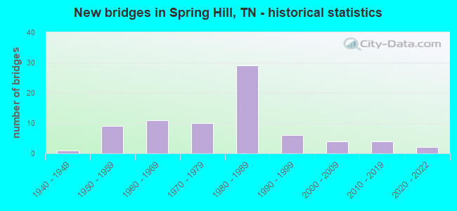
- New bridges - historical statistics
- 11940-1949
- 91950-1959
- 111960-1969
- 101970-1979
- 291980-1989
- 61990-1999
- 42000-2009
- 42010-2019
- 22020-2022

- Reconstructed bridges - Historical Statistics
- 11980-1989
- 11990-1999
- 02000-2009
- 02010-2019
- 12020-2022


- Bridge Condition - Deck
- 16.7%Very good
- 26.7%Good
- 6.7%Satisfactory
- 46.7%Fair
- 3.3%Poor

- Bridge Condition - Superstructure
- 3.3%Excellent
- 23.3%Very good
- 10.0%Good
- 40.0%Satisfactory
- 20.0%Fair
- 3.3%Poor

- Bridge Condition - Substructure
- 20.0%Very good
- 20.0%Good
- 10.0%Satisfactory
- 50.0%Fair

- Bridge Condition - Channel
- 48.1%Very good
- 22.2%Good
- 24.1%Satisfactory
- 5.6%Fair

- Bridge Condition - Culverts
- 24.2%Good
- 6.1%Satisfactory
- 69.7%Fair
Find on map >> Show street view
Structure Number: 60S63220007, Location: 0.5 M. S. SPRING HILL (Lat: 35.740983, Lng: -86.924817), Route carried "on" structure: City street 1907, Year Built: 1960, Status: Open, Structure Length: 1.01m (3.31ft), Average Daily Traffic: 5,318 (year 2020), Truck Traffic: 3%, Average Future Daily Traffic: 9,616 (year 2040), Design Load: HS 20, Features Intersected: BRANCH
Minimum Vertical Clearance: 30+ m (98+ ft), Kilometerpoint: 5.456, Lanes on structure: 2, Owner: City or Municipal Highway Agency, Approaching Roadway Width: 6.1m (20.0ft), Skew: 1 degrees, Material/Design: Concrete continuous, Design/Construction: Culvert, Number Of Spans In Main Unit: 3, Length of Maximum Span: 4.6m (15.1ft)
Condition: Channel: Good, Culverts: Satisfactory, Operating Rating: 89.1 metric tons, Method Used To Determine Operating Rating: Load Factor (LF), Inventory Rating: 32.4 metric tons, Method Used To Determine Inventory Rating: Load Factor (LF), Structural Evaluation: Equal to present minimum criteria, Waterway Adequacy: Equal to present minimum criteria, Approach Roadway Alignment: Equal to present desirable criteria, Designated Inspection Frequency: Every 24 months, Inspection Date: May 2020
Find on map >> Show street view
Structure Number: 60SR0060029, Location: 6.31 MI.N. JCT.FAS 6181 (Lat: 35.743683, Lng: -86.939350), Route carried "on" structure: US 31, Year Built: 1954, Status: Open, Structure Length: 1.19m (3.90ft), Average Daily Traffic: 17,360 (year 2020), Truck Traffic: 9%, Average Future Daily Traffic: 46,624 (year 2040), Design Load: HS 20, Features Intersected: BRANCH, Facility Carried by Structure: FAP 6
Minimum Vertical Clearance: 30+ m (98+ ft), Kilometerpoint: 51.725, Lanes on structure: 4, Base Highway Network: Yes, Owner: State Highway Agency, Approaching Roadway Width: 31.7m (104.0ft), Material/Design: Concrete continuous, Design/Construction: Culvert, Number Of Spans In Main Unit: 3, Length of Maximum Span: 3.7m (12.1ft)
Condition: Channel: Satisfactory, Culverts: Fair, Operating Rating: 58.5 metric tons, Method Used To Determine Operating Rating: Load Factor (LF), Inventory Rating: 32.4 metric tons, Method Used To Determine Inventory Rating: Load Factor (LF), Structural Evaluation: Somewhat better than minimum adequacy, Waterway Adequacy: Equal to present minimum criteria, Approach Roadway Alignment: Equal to present desirable criteria, Length Of Structure Improvement: 1.19m (3.90ft), Designated Inspection Frequency: Every 24 months, Inspection Date: March 2020, Bridge Improvement Cost: $345,000, Roadway Improvement Cost: $35,000, Total Project Cost: $518,000 ( Estimate for 2020)
Find on map >> Show street view
Structure Number: 60SR0060079, Location: 2.5 M S SR 247 (Lat: 35.738200, Lng: -86.947100), Route carried "on" structure: US 31, Year Built: 1989, Status: Open, Structure Length: 7.13m (23.39ft), Average Daily Traffic: 17,360 (year 2020), Truck Traffic: 9%, Average Future Daily Traffic: 46,624 (year 2040), Design Load: HS 20, Features Intersected: SR 6-STR. 1 / SR 396, Facility Carried by Structure: FAP 6
Minimum Vertical Clearance: 30+ m (98+ ft), Kilometerpoint: 50.791, Lanes on structure: 4, Lanes under structure: 5, Base Highway Network: Yes, Owner: State Highway Agency, Approaching Roadway Width: 41.1m (134.8ft), Skew: 2 degrees, Material/Design: Steel continuous, Design/Construction: Stringer/Multi-beam, Number Of Spans In Main Unit: 2, Length of Maximum Span: 37.5m (123.0ft), Curb-To-Curb Width: 40.5m (132.9ft), Out-to-Out Width: 41.1m (134.8ft)
Condition: Deck: Good, Superstructure: Satisfactory, Substructure: Fair, Operating Rating: 56.7 metric tons, Method Used To Determine Operating Rating: Load Factor (LF), Inventory Rating: 34.2 metric tons, Method Used To Determine Inventory Rating: Load Factor (LF), Structural Evaluation: Somewhat better than minimum adequacy, Deck Geometry: Superior to present desirable criteria, Underclear: Equal to present minimum criteria, Approach Roadway Alignment: Equal to present desirable criteria, Length Of Structure Improvement: 7.13m (23.39ft), Designated Inspection Frequency: Every 24 months, Inspection Date: March 2020, Bridge Improvement Cost: $394,000, Roadway Improvement Cost: $40,000, Total Project Cost: $592,000 ( Estimate for 2020), Deck Structure Type: Concrete Cast-file-Place, Wearing Surface/Protective System: Wearing Surface: Monolithic Concrete, Deck Protection: Epoxy Coated Reinforcing
Find on map >> Show street view
Structure Number: 60SR0060081, Location: 2.5 M S SR 247 (Lat: 35.738967, Lng: -86.945767), Route carried "on" structure: Ramp State highway 396, Year Built: 1989, Status: Open, Structure Length: 7.68m (25.20ft), Average Daily Traffic: 33,305 (year 2020), Truck Traffic: 13%, Average Future Daily Traffic: 1,168 (year 2040), Design Load: HS 20, Features Intersected: SR396-RAMP-STR 3 / SR 6
Minimum Vertical Clearance: 30+ m (98+ ft), Kilometerpoint: 0.000, Lanes on structure: 1, Lanes under structure: 5, Base Highway Network: Yes, Owner: State Highway Agency, Approaching Roadway Width: 9.1m (29.9ft), Material/Design: Steel continuous, Design/Construction: Stringer/Multi-beam, Number Of Spans In Main Unit: 2, Length of Maximum Span: 43.0m (141.1ft), Curb-To-Curb Width: 9.1m (29.9ft), Out-to-Out Width: 9.8m (32.2ft)
Condition: Deck: Fair, Superstructure: Satisfactory, Substructure: Fair, Operating Rating: 89.1 metric tons, Method Used To Determine Operating Rating: Load Factor (LF), Inventory Rating: 32.4 metric tons, Method Used To Determine Inventory Rating: Load Factor (LF), Structural Evaluation: Somewhat better than minimum adequacy, Deck Geometry: Superior to present desirable criteria, Underclear: Better than present minimum criteria, Approach Roadway Alignment: Equal to present desirable criteria, Designated Inspection Frequency: Every 24 months, Inspection Date: March 2020, Deck Structure Type: Concrete Cast-file-Place, Wearing Surface/Protective System: Wearing Surface: Monolithic Concrete, Deck Protection: Epoxy Coated Reinforcing
Find on map >> Show street view
Structure Number: 60SR1060003, Location: 5 MILES N.OF LEE'S CORNER (Lat: 35.704700, Lng: -86.835250), Route carried "on" structure: US 431, Year Built: 1947, Year Reconstructed: 2003, Status: Open, Structure Length: 1.22m (4.00ft), Average Daily Traffic: 4,911 (year 2020), Truck Traffic: 11%, Average Future Daily Traffic: 8,016 (year 2040), Design Load: HS 20+Mod, Features Intersected: CARLTON BRANCH, Facility Carried by Structure: FAS 106
Minimum Vertical Clearance: 30+ m (98+ ft), Kilometerpoint: 9.205, Lanes on structure: 2, Base Highway Network: Yes, Owner: State Highway Agency, Approaching Roadway Width: 8.5m (27.9ft), Material/Design: Prestressed concrete, Design/Construction: Box Beam or Girders - Single/Spread, Number Of Spans In Main Unit: 1, Length of Maximum Span: 12.2m (40.0ft), Curb-To-Curb Width: 10.7m (35.1ft), Out-to-Out Width: 11.4m (37.4ft)
Condition: Deck: Very good, Superstructure: Very good, Substructure: Fair, Channel: Very good, Operating Rating: 44.1 metric tons, Method Used To Determine Operating Rating: Assigned rating based on Load Factor Design (LFD) reported in metric tons, Inventory Rating: 32.4 metric tons, Method Used To Determine Inventory Rating: Assigned rating based on Load Factor Design (LFD) reported in metric tons, Structural Evaluation: Somewhat better than minimum adequacy, Deck Geometry: Somewhat better than minimum adequacy, Waterway Adequacy: Equal to present desirable criteria, Approach Roadway Alignment: Equal to present desirable criteria, Length Of Structure Improvement: 1.22m (4.00ft), Designated Inspection Frequency: Every 24 months, Inspection Date: March 2020, Bridge Improvement Cost: $105,000, Roadway Improvement Cost: $11,000, Total Project Cost: $158,000 ( Estimate for 2020), Deck Structure Type: Concrete Cast-file-Place, Wearing Surface/Protective System: Wearing Surface: Bituminous
Find on map >> Show street view
Structure Number: 60SR1060005, Location: 3 MI E OF I65 (Lat: 35.695433, Lng: -86.831983), Route carried "on" structure: State highway 106, Year Built: 2001, Status: Open, Structure Length: 0.67m (2.20ft), Average Daily Traffic: 4,911 (year 2020), Truck Traffic: 11%, Average Future Daily Traffic: 8,016 (year 2040), Design Load: HS 20, Features Intersected: LITTLE FLAT CREEK
Minimum Vertical Clearance: 30+ m (98+ ft), Kilometerpoint: 8.143, Lanes on structure: 2, Base Highway Network: Yes, Owner: State Highway Agency, Approaching Roadway Width: 9.4m (30.8ft), Skew: 1 degrees, Material/Design: Concrete, Design/Construction: Culvert, Number Of Spans In Main Unit: 2, Length of Maximum Span: 4.6m (15.1ft), Curb-To-Curb Width: 9.4m (30.8ft), Out-to-Out Width: 14.5m (47.6ft)
Condition: Channel: Very good, Culverts: Fair, Operating Rating: 89.1 metric tons, Method Used To Determine Operating Rating: Load Factor (LF), Inventory Rating: 32.4 metric tons, Method Used To Determine Inventory Rating: Load Factor (LF), Structural Evaluation: Somewhat better than minimum adequacy, Deck Geometry: Meets minimum limits, Waterway Adequacy: Equal to present desirable criteria, Approach Roadway Alignment: Equal to present desirable criteria, Length Of Structure Improvement: 0.67m (2.20ft), Designated Inspection Frequency: Every 24 months, Inspection Date: March 2020, Bridge Improvement Cost: $1,000, Roadway Improvement Cost: $1,000, Total Project Cost: $2,000 ( Estimate for 2020), Deck Structure Type: Concrete Cast-file-Place, Wearing Surface/Protective System: Wearing Surface: Bituminous
Find on map >> Show street view
Structure Number: 60SR2430001, Location: IN COLUMBIA (Lat: 35.602933, Lng: -87.068300), Route carried "on" structure: State highway 243, Year Built: 1989, Status: Open, Structure Length: 0.67m (2.20ft), Average Daily Traffic: 17,770 (year 2020), Truck Traffic: 3%, Average Future Daily Traffic: 30,000 (year 2040), Design Load: HS 20, Features Intersected: BRANCH, Facility Carried by Structure: FAU 6
Minimum Vertical Clearance: 30+ m (98+ ft), Kilometerpoint: 16.592, Lanes on structure: 4, Owner: State Highway Agency, Approaching Roadway Width: 17.7m (58.1ft), Material/Design: Concrete continuous, Design/Construction: Culvert, Number Of Spans In Main Unit: 2, Length of Maximum Span: 3.0m (9.8ft)
Condition: Channel: Good, Culverts: Fair, Operating Rating: 89.1 metric tons, Method Used To Determine Operating Rating: Load Factor (LF), Inventory Rating: 32.4 metric tons, Method Used To Determine Inventory Rating: Load Factor (LF), Structural Evaluation: Somewhat better than minimum adequacy, Waterway Adequacy: Equal to present minimum criteria, Approach Roadway Alignment: Equal to present desirable criteria, Length Of Structure Improvement: 0.67m (2.20ft), Designated Inspection Frequency: Every 24 months, Inspection Date: April 2020, Bridge Improvement Cost: $207,000, Roadway Improvement Cost: $21,000, Total Project Cost: $311,000 ( Estimate for 2020), Deck Structure Type: Concrete Cast-file-Place, Wearing Surface/Protective System: Wearing Surface: Bituminous
Find on map >> Show street view
Structure Number: 60SR2470003, Location: 1.8 M E JCT SR246&SR247 (Lat: 35.752542, Lng: -86.951858), Route carried "on" structure: State highway 247, Year Built: 2020, Status: Open, Structure Length: 1.33m (4.36ft), Average Daily Traffic: 6,179 (year 2020), Truck Traffic: 3%, Average Future Daily Traffic: 9,886 (year 2041), Design Load: HL 93, Features Intersected: CSX
Minimum Vertical Clearance: 30+ m (98+ ft), Kilometerpoint: 29.435, Lanes on structure: 2, Owner: State Highway Agency, Approaching Roadway Width: 16.0m (52.5ft), Material/Design: Steel continuous, Design/Construction: Stringer/Multi-beam, Number Of Spans In Main Unit: 2, Length of Maximum Span: 13.3m (43.6ft), Curb or Sidewalk Widths: Left: 2.4m (7.9ft), Right: 2.4m (7.9ft), Curb-To-Curb Width: 12.2m (40.0ft), Out-to-Out Width: 16.0m (52.5ft)
Condition: Deck: Very good, Superstructure: Very good, Substructure: Very good, Operating Rating: 44.1 metric tons, Method Used To Determine Operating Rating: Load Factor (LF), Inventory Rating: 32.4 metric tons, Method Used To Determine Inventory Rating: Load Factor (LF), Structural Evaluation: Equal to present desirable criteria, Deck Geometry: Somewhat better than minimum adequacy, Approach Roadway Alignment: Equal to present desirable criteria, Designated Inspection Frequency: Every 24 months, Inspection Date: October 2020, Deck Structure Type: Concrete Cast-file-Place, Wearing Surface/Protective System: Wearing Surface: Bituminous
Find on map >> Show street view
Structure Number: 60SR2470005, Location: 3 M E JCT SR246&SR247 (Lat: 35.752833, Lng: -86.948633), Route carried "on" structure: State highway 247, Year Built: 1950, Status: Open, Structure Length: 0.67m (2.20ft), Average Daily Traffic: 6,179 (year 2020), Truck Traffic: 3%, Average Future Daily Traffic: 9,886 (year 2041), Design Load: H 15, Features Intersected: BRANCH
Minimum Vertical Clearance: 30+ m (98+ ft), Kilometerpoint: 29.773, Lanes on structure: 2, Owner: State Highway Agency, Approaching Roadway Width: 6.7m (22.0ft), Material/Design: Concrete, Design/Construction: Arch - Deck, Number Of Spans In Main Unit: 1, Length of Maximum Span: 6.4m (21.0ft), Curb-To-Curb Width: 7.4m (24.3ft), Out-to-Out Width: 8.1m (26.6ft)
Condition: Deck: Very good, Superstructure: Excellent, Substructure: Very good, Channel: Very good, Operating Rating: 27.0 metric tons, Method Used To Determine Operating Rating: Load Factor (LF), Inventory Rating: 24.3 metric tons, Method Used To Determine Inventory Rating: Load Factor (LF), Structural Evaluation: Equal to present minimum criteria, Deck Geometry: High priority of replacement, Waterway Adequacy: Better than present minimum criteria, Approach Roadway Alignment: Equal to present desirable criteria, Designated Inspection Frequency: Every 24 months, Inspection Date: May 2020, Deck Structure Type: Concrete Cast-file-Place, Wearing Surface/Protective System: Wearing Surface: Bituminous
Find on map >> Show street view
Structure Number: 60SR3960001, Location: .8 M S JCT I65 & SR 247 (Lat: 35.745683, Lng: -86.870567), Route carried "on" structure: Ramp State highway 396, Year Built: 1989, Status: Open, Structure Length: 0.67m (2.20ft), Average Daily Traffic: 38,563 (year 2020), Truck Traffic: 13%, Average Future Daily Traffic: 17,008 (year 2040), Design Load: HS 20, Features Intersected: BRANCH
Minimum Vertical Clearance: 30+ m (98+ ft), Kilometerpoint: 7.178, Lanes on structure: 2, Base Highway Network: Yes, Owner: State Highway Agency, Approaching Roadway Width: 12.2m (40.0ft), Skew: 3 degrees, Material/Design: Concrete continuous, Design/Construction: Culvert, Number Of Spans In Main Unit: 2, Length of Maximum Span: 3.0m (9.8ft), Curb-To-Curb Width: 18.6m (61.0ft), Out-to-Out Width: 19.2m (63.0ft)
Condition: Channel: Very good, Culverts: Fair, Operating Rating: 70.2 metric tons, Method Used To Determine Operating Rating: Load Factor (LF), Inventory Rating: 32.4 metric tons, Method Used To Determine Inventory Rating: Load Factor (LF), Structural Evaluation: Somewhat better than minimum adequacy, Deck Geometry: Superior to present desirable criteria, Waterway Adequacy: Equal to present minimum criteria, Approach Roadway Alignment: Equal to present desirable criteria, Length Of Structure Improvement: 0.67m (2.20ft), Designated Inspection Frequency: Every 24 months, Inspection Date: March 2020, Bridge Improvement Cost: $1,000, Roadway Improvement Cost: $1,000, Total Project Cost: $2,000 ( Estimate for 2020), Wearing Surface/Protective System: Wearing Surface: Monolithic Concrete
Find on map >> Show street view
Structure Number: 60SR3960003, Location: SATURN PKWY @ SPRING HILL (Lat: 35.732483, Lng: -86.925100), Route carried "on" structure: State highway 396, Year Built: 1989, Status: Open, Structure Length: 9.51m (31.20ft), Average Daily Traffic: 32,065 (year 2020), Truck Traffic: 13%, Average Future Daily Traffic: 55,184 (year 2040), Design Load: HS 20, Features Intersected: SR396 RL/NFA 1907 & A CR
Minimum Vertical Clearance: 30+ m (98+ ft), Kilometerpoint: 2.301, Lanes on structure: 2, Lanes under structure: 5, Base Highway Network: Yes, Owner: State Highway Agency, Approaching Roadway Width: 12.8m (42.0ft), Material/Design: Steel continuous, Design/Construction: Stringer/Multi-beam, Number Of Spans In Main Unit: 2, Length of Maximum Span: 61.9m (203.1ft), Curb-To-Curb Width: 12.8m (42.0ft), Out-to-Out Width: 13.4m (44.0ft)
Condition: Deck: Fair, Superstructure: Satisfactory, Substructure: Fair, Channel: Very good, Operating Rating: 66.6 metric tons, Method Used To Determine Operating Rating: Load Factor (LF), Inventory Rating: 39.6 metric tons, Method Used To Determine Inventory Rating: Load Factor (LF), Structural Evaluation: Somewhat better than minimum adequacy, Deck Geometry: Equal to present desirable criteria, Underclear: Superior to present desirable criteria, Waterway Adequacy: Equal to present minimum criteria, Approach Roadway Alignment: Equal to present desirable criteria, Length Of Structure Improvement: 9.51m (31.20ft), Designated Inspection Frequency: Every 24 months, Inspection Date: March 2020, Bridge Improvement Cost: $1,000, Roadway Improvement Cost: $1,000, Total Project Cost: $2,000 ( Estimate for 2020), Deck Structure Type: Concrete Cast-file-Place, Wearing Surface/Protective System: Wearing Surface: Monolithic Concrete, Deck Protection: Epoxy Coated Reinforcing
Find on map >> Show street view
Structure Number: 60SR3960004, Location: SATURN PKWY @ SPRINGHILL (Lat: 35.732717, Lng: -86.925117), Route carried "on" structure: State highway 396, Year Built: 1989, Status: Open, Structure Length: 9.51m (31.20ft), Average Daily Traffic: 32,065 (year 2020), Truck Traffic: 13%, Average Future Daily Traffic: 55,184 (year 2040), Design Load: HS 20, Features Intersected: SR396LL/NFA 1907 @ A CR
Minimum Vertical Clearance: 30+ m (98+ ft), Kilometerpoint: 2.301, Lanes on structure: 2, Lanes under structure: 5, Base Highway Network: Yes, Owner: State Highway Agency, Approaching Roadway Width: 12.8m (42.0ft), Material/Design: Steel continuous, Design/Construction: Stringer/Multi-beam, Number Of Spans In Main Unit: 2, Length of Maximum Span: 61.9m (203.1ft), Curb-To-Curb Width: 12.8m (42.0ft), Out-to-Out Width: 13.4m (44.0ft)
Condition: Deck: Fair, Superstructure: Satisfactory, Substructure: Fair, Channel: Very good, Operating Rating: 66.6 metric tons, Method Used To Determine Operating Rating: Load Factor (LF), Inventory Rating: 39.6 metric tons, Method Used To Determine Inventory Rating: Load Factor (LF), Structural Evaluation: Somewhat better than minimum adequacy, Deck Geometry: Equal to present desirable criteria, Underclear: Better than present minimum criteria, Waterway Adequacy: Equal to present minimum criteria, Approach Roadway Alignment: Equal to present desirable criteria, Length Of Structure Improvement: 9.51m (31.20ft), Designated Inspection Frequency: Every 24 months, Inspection Date: March 2020, Bridge Improvement Cost: $1,000, Roadway Improvement Cost: $1,000, Total Project Cost: $2,000 ( Estimate for 2020), Deck Structure Type: Concrete Cast-file-Place, Wearing Surface/Protective System: Wearing Surface: Monolithic Concrete, Deck Protection: Epoxy Coated Reinforcing
Find on map >> Show street view
Structure Number: 60SR3960005, Location: IN SPRINGHILL NEAR KEDRON (Lat: 35.730700, Lng: -86.924500), Route carried "on" structure: Ramp State highway 396, Year Built: 1989, Status: Open, Structure Length: 1.77m (5.81ft), Average Daily Traffic: 32,065 (year 2020), Truck Traffic: 13%, Average Future Daily Traffic: 1,936 (year 2038), Design Load: HS 20, Features Intersected: SR396-RT RMP/MCCUTHEON C
Minimum Vertical Clearance: 30+ m (98+ ft), Kilometerpoint: 2.350, Lanes on structure: 1, Base Highway Network: Yes, Owner: State Highway Agency, Approaching Roadway Width: 9.4m (30.8ft), Material/Design: Concrete continuous, Design/Construction: Culvert, Number Of Spans In Main Unit: 3, Length of Maximum Span: 5.5m (18.0ft)
Condition: Channel: Very good, Culverts: Fair, Operating Rating: 63.0 metric tons, Method Used To Determine Operating Rating: Load Factor (LF), Inventory Rating: 32.4 metric tons, Method Used To Determine Inventory Rating: Load Factor (LF), Structural Evaluation: Somewhat better than minimum adequacy, Waterway Adequacy: Equal to present minimum criteria, Approach Roadway Alignment: Equal to present desirable criteria, Designated Inspection Frequency: Every 24 months, Inspection Date: March 2020
Find on map >> Show street view
Structure Number: 60SR3960006, Location: IN SPRINGHILL NEAR KEDRON (Lat: 35.733850, Lng: -86.924483), Route carried "on" structure: Ramp State highway 396, Year Built: 1989, Status: Open, Structure Length: 1.89m (6.20ft), Average Daily Traffic: 32,065 (year 2020), Truck Traffic: 13%, Average Future Daily Traffic: 1,952 (year 2038), Design Load: HS 20, Features Intersected: SR396-LF RMP/MCCUTHEON C
Minimum Vertical Clearance: 30+ m (98+ ft), Kilometerpoint: 2.350, Lanes on structure: 1, Base Highway Network: Yes, Owner: State Highway Agency, Approaching Roadway Width: 9.1m (29.9ft), Skew: 2 degrees, Material/Design: Concrete continuous, Design/Construction: Culvert, Number Of Spans In Main Unit: 3, Length of Maximum Span: 5.5m (18.0ft)
Condition: Channel: Satisfactory, Culverts: Fair, Operating Rating: 60.3 metric tons, Method Used To Determine Operating Rating: Load Factor (LF), Inventory Rating: 32.4 metric tons, Method Used To Determine Inventory Rating: Load Factor (LF), Structural Evaluation: Somewhat better than minimum adequacy, Waterway Adequacy: Equal to present minimum criteria, Approach Roadway Alignment: Equal to present desirable criteria, Designated Inspection Frequency: Every 24 months, Inspection Date: March 2020
Find on map >> Show street view
Structure Number: 60SR3960007, Location: PORT ROYAL RD IN COLUMBIA (Lat: 35.734067, Lng: -86.894017), Route carried "on" structure: City street 125, Year Built: 1989, Status: Open, Structure Length: 6.77m (22.21ft), Average Daily Traffic: 14,435 (year 2020), Truck Traffic: 3%, Average Future Daily Traffic: 22,864 (year 2040), Design Load: HS 20, Features Intersected: PORT ROYAL RD / SR 396
Minimum Vertical Clearance: 30+ m (98+ ft), Kilometerpoint: 3.581, Lanes on structure: 4, Lanes under structure: 4, Owner: State Highway Agency, Approaching Roadway Width: 33.5m (109.9ft), Skew: 20 degrees, Material/Design: Steel continuous, Design/Construction: Stringer/Multi-beam, Number Of Spans In Main Unit: 2, Length of Maximum Span: 33.5m (109.9ft), Curb-To-Curb Width: 33.5m (109.9ft), Out-to-Out Width: 34.1m (111.9ft)
Condition: Deck: Fair, Superstructure: Satisfactory, Substructure: Fair, Operating Rating: 36.9 metric tons, Method Used To Determine Operating Rating: Load Factor (LF), Inventory Rating: 21.6 metric tons, Method Used To Determine Inventory Rating: Load Factor (LF), Structural Evaluation: Somewhat better than minimum adequacy, Deck Geometry: Superior to present desirable criteria, Underclear: Better than present minimum criteria, Approach Roadway Alignment: Equal to present desirable criteria, Length Of Structure Improvement: 6.77m (22.21ft), Designated Inspection Frequency: Every 24 months, Inspection Date: March 2020, Bridge Improvement Cost: $3,713,000, Roadway Improvement Cost: $372,000, Total Project Cost: $5,570,000 ( Estimate for 2020), Deck Structure Type: Concrete Cast-file-Place, Wearing Surface/Protective System: Wearing Surface: Monolithic Concrete, Deck Protection: Epoxy Coated Reinforcing
Find on map >> Show street view
Structure Number: 60SR3960009, Location: NEAR PORT ROYAL ROAD (Lat: 35.733900, Lng: -86.899200), Route carried "on" structure: State highway 396, Year Built: 1990, Status: Open, Structure Length: 1.28m (4.20ft), Average Daily Traffic: 32,065 (year 2020), Truck Traffic: 13%, Average Future Daily Traffic: 55,184 (year 2040), Design Load: HS 20, Features Intersected: AENON CREEK
Minimum Vertical Clearance: 30+ m (98+ ft), Kilometerpoint: 4.699, Lanes on structure: 4, Base Highway Network: Yes, Owner: State Highway Agency, Approaching Roadway Width: 41.1m (134.8ft), Skew: 2 degrees, Material/Design: Concrete continuous, Design/Construction: Culvert, Number Of Spans In Main Unit: 3, Length of Maximum Span: 3.7m (12.1ft)
Condition: Channel: Very good, Culverts: Fair, Operating Rating: 54.0 metric tons, Method Used To Determine Operating Rating: Field evaluation and documented engineering judgment, Inventory Rating: 32.4 metric tons, Method Used To Determine Inventory Rating: Field evaluation and documented engineering judgment, Structural Evaluation: Somewhat better than minimum adequacy, Waterway Adequacy: Equal to present minimum criteria, Approach Roadway Alignment: Equal to present desirable criteria, Length Of Structure Improvement: 1.28m (4.20ft), Designated Inspection Frequency: Every 24 months, Inspection Date: March 2020, Bridge Improvement Cost: $368,000, Roadway Improvement Cost: $37,000, Total Project Cost: $553,000 ( Estimate for 2020)
Find on map >> Show street view
Structure Number: 60SR3960011, Location: NEAR I65 & WILLIAM CO LN (Lat: 35.738750, Lng: -86.881483), Route carried "on" structure: State highway 396, Year Built: 1989, Status: Open, Structure Length: 1.92m (6.30ft), Average Daily Traffic: 38,563 (year 2020), Truck Traffic: 13%, Average Future Daily Traffic: 70,912 (year 2040), Design Load: HS 20, Features Intersected: AENON CREEK
Minimum Vertical Clearance: 30+ m (98+ ft), Kilometerpoint: 6.437, Lanes on structure: 5, Base Highway Network: Yes, Owner: State Highway Agency, Approaching Roadway Width: 63.4m (208.0ft), Skew: 2 degrees, Material/Design: Concrete continuous, Design/Construction: Culvert, Number Of Spans In Main Unit: 3, Length of Maximum Span: 5.5m (18.0ft)
Condition: Channel: Very good, Culverts: Fair, Operating Rating: 54.0 metric tons, Method Used To Determine Operating Rating: Field evaluation and documented engineering judgment, Inventory Rating: 32.4 metric tons, Method Used To Determine Inventory Rating: Field evaluation and documented engineering judgment, Structural Evaluation: Somewhat better than minimum adequacy, Waterway Adequacy: Equal to present minimum criteria, Approach Roadway Alignment: Equal to present desirable criteria, Length Of Structure Improvement: 1.92m (6.30ft), Designated Inspection Frequency: Every 24 months, Inspection Date: March 2020, Bridge Improvement Cost: $631,000, Roadway Improvement Cost: $64,000, Total Project Cost: $947,000 ( Estimate for 2020)
Find on map >> Show street view
Structure Number: 60SR3960013, Location: SATURN PKWY @ SPRINGHILL (Lat: 35.732717, Lng: -86.925117), Route carried "on" structure: State highway 396, Year Built: 2020, Status: Open, Structure Length: 2.24m (7.35ft), Average Daily Traffic: 33,305 (year 2020), Truck Traffic: 13%, Average Future Daily Traffic: 57,888 (year 2041), Design Load: HL 93, Features Intersected: SR396LL/NFA 1907 @ A CR
Minimum Vertical Clearance: 30+ m (98+ ft), Kilometerpoint: 1.609, Lanes on structure: 2, Lanes under structure: 2, Base Highway Network: Yes, Owner: State Highway Agency, Approaching Roadway Width: 7.3m (24.0ft), Material/Design: Prestressed concrete, Design/Construction: Stringer/Multi-beam, Number Of Spans In Main Unit: 1, Length of Maximum Span: 22.4m (73.5ft), Curb-To-Curb Width: 7.3m (24.0ft), Out-to-Out Width: 12.4m (40.7ft)
Condition: Deck: Good, Superstructure: Good, Substructure: Good, Channel: Very good, Operating Rating: 44.1 metric tons, Method Used To Determine Operating Rating: Assigned ratings based on Load and Resistance Factor Design (LRFD) reported by rating factor (RF) using HL93 loadings, Inventory Rating: 32.4 metric tons, Method Used To Determine Inventory Rating: Assigned ratings based on Load and Resistance Factor Design (LRFD) reported by rating factor (RF) using HL93 loadings, Structural Evaluation: Better than present minimum criteria, Deck Geometry: High priority of replacement, Underclear: Superior to present desirable criteria, Approach Roadway Alignment: Equal to present desirable criteria, Designated Inspection Frequency: Every 24 months, Inspection Date: May 2020, Deck Structure Type: Concrete Cast-file-Place, Wearing Surface/Protective System: Wearing Surface: Monolithic Concrete, Deck Protection: Epoxy Coated Reinforcing
Find on map >> Show street view
Structure Number: 94I00650041, Location: .8 M S JCT I65 & SR 247 (Lat: 35.742733, Lng: -86.874350), Route carried "on" structure: Ramp Interstate 65, Year Built: 1989, Status: Open, Structure Length: 0.67m (2.20ft), Average Daily Traffic: 84,324 (year 2020), Truck Traffic: 16%, Average Future Daily Traffic: 130,928 (year 2041), Design Load: HS 20, Features Intersected: BRANCH
Minimum Vertical Clearance: 30+ m (98+ ft), Kilometerpoint: 0.595, Lanes on structure: 2, Base Highway Network: Yes, Owner: State Highway Agency, Approaching Roadway Width: 11.6m (38.1ft), Material/Design: Concrete continuous, Design/Construction: Culvert, Number Of Spans In Main Unit: 2, Length of Maximum Span: 3.0m (9.8ft)
Condition: Channel: Good, Culverts: Good, Operating Rating: 89.1 metric tons, Method Used To Determine Operating Rating: Load Factor (LF), Inventory Rating: 32.4 metric tons, Method Used To Determine Inventory Rating: Load Factor (LF), Structural Evaluation: Better than present minimum criteria, Waterway Adequacy: Better than present minimum criteria, Approach Roadway Alignment: Equal to present desirable criteria, Designated Inspection Frequency: Every 24 months, Inspection Date: Febuary 2021
Find on map >> Show street view
Structure Number: 94S62510001, Location: 1 M E MAURY CO LINE (Lat: 35.752600, Lng: -86.893650), Route carried "on" structure: State highway 247, Year Built: 1979, Status: Open, Structure Length: 1.01m (3.31ft), Average Daily Traffic: 9,256 (year 2020), Truck Traffic: 4%, Average Future Daily Traffic: 14,384 (year 2041), Design Load: HS 20, Features Intersected: GRASSY BRANCH
Minimum Vertical Clearance: 30+ m (98+ ft), Kilometerpoint: 1.698, Lanes on structure: 2, Owner: State Highway Agency, Approaching Roadway Width: 7.9m (25.9ft), Material/Design: Concrete continuous, Design/Construction: Culvert, Number Of Spans In Main Unit: 2, Length of Maximum Span: 4.6m (15.1ft), Curb-To-Curb Width: 8.5m (27.9ft), Out-to-Out Width: 9.1m (29.9ft)
Condition: Channel: Satisfactory, Culverts: Good, Operating Rating: 48.6 metric tons, Method Used To Determine Operating Rating: Load Factor (LF), Inventory Rating: 28.8 metric tons, Method Used To Determine Inventory Rating: Load Factor (LF), Structural Evaluation: Better than present minimum criteria, Deck Geometry: High priority of replacement, Waterway Adequacy: Equal to present minimum criteria, Approach Roadway Alignment: Equal to present desirable criteria, Length Of Structure Improvement: 1.01m (3.31ft), Designated Inspection Frequency: Every 24 months, Inspection Date: Febuary 2021, Bridge Improvement Cost: $142,000, Roadway Improvement Cost: $15,000, Total Project Cost: $214,000 ( Estimate for 2021), Deck Structure Type: Concrete Cast-file-Place, Wearing Surface/Protective System: Wearing Surface: Bituminous
Find on map >> Show street view
Structure Number: 94S62510003, Location: 2.1M E MAURY CO LINE (Lat: 35.752783, Lng: -86.874400), Route carried "on" structure: State highway 247, Year Built: 1979, Status: Open, Structure Length: 1.49m (4.89ft), Average Daily Traffic: 2,874 (year 2020), Truck Traffic: 5%, Average Future Daily Traffic: 6,512 (year 2041), Design Load: HS 20, Features Intersected: AENON CREEK
Minimum Vertical Clearance: 30+ m (98+ ft), Kilometerpoint: 3.404, Lanes on structure: 2, Owner: State Highway Agency, Approaching Roadway Width: 7.9m (25.9ft), Material/Design: Concrete continuous, Design/Construction: Culvert, Number Of Spans In Main Unit: 3, Length of Maximum Span: 4.6m (15.1ft), Curb-To-Curb Width: 8.6m (28.2ft), Out-to-Out Width: 9.2m (30.2ft)
Condition: Channel: Satisfactory, Culverts: Good, Operating Rating: 61.2 metric tons, Method Used To Determine Operating Rating: Load Factor (LF), Inventory Rating: 32.4 metric tons, Method Used To Determine Inventory Rating: Load Factor (LF), Structural Evaluation: Better than present minimum criteria, Deck Geometry: Meets minimum limits, Waterway Adequacy: Equal to present minimum criteria, Approach Roadway Alignment: Equal to present desirable criteria, Length Of Structure Improvement: 1.49m (4.89ft), Designated Inspection Frequency: Every 24 months, Inspection Date: Febuary 2021, Bridge Improvement Cost: $145,000, Roadway Improvement Cost: $15,000, Total Project Cost: $218,000 ( Estimate for 2021), Deck Structure Type: Concrete Cast-file-Place, Wearing Surface/Protective System: Wearing Surface: Bituminous
Find on map >> Show street view
Structure Number: 94S62510005, Location: .2 MI.W.OF LEWISBURG PIKE (Lat: 35.746617, Lng: -86.840400), Route carried "on" structure: State highway 247, Year Built: 1979, Status: Open, Structure Length: 1.01m (3.31ft), Average Daily Traffic: 2,874 (year 2020), Truck Traffic: 5%, Average Future Daily Traffic: 6,512 (year 2041), Design Load: HS 20, Features Intersected: MUD CREEK
Minimum Vertical Clearance: 30+ m (98+ ft), Kilometerpoint: 6.647, Lanes on structure: 2, Owner: State Highway Agency, Approaching Roadway Width: 7.9m (25.9ft), Material/Design: Concrete continuous, Design/Construction: Culvert, Number Of Spans In Main Unit: 2, Length of Maximum Span: 4.6m (15.1ft), Curb-To-Curb Width: 7.9m (25.9ft), Out-to-Out Width: 8.5m (27.9ft)
Condition: Channel: Satisfactory, Culverts: Good, Operating Rating: 54.9 metric tons, Method Used To Determine Operating Rating: Load Factor (LF), Inventory Rating: 32.4 metric tons, Method Used To Determine Inventory Rating: Load Factor (LF), Structural Evaluation: Better than present minimum criteria, Deck Geometry: High priority of corrective action, Waterway Adequacy: Somewhat better than minimum adequacy, Approach Roadway Alignment: Equal to present desirable criteria, Length Of Structure Improvement: 1.01m (3.31ft), Designated Inspection Frequency: Every 24 months, Inspection Date: Febuary 2021, Bridge Improvement Cost: $121,000, Roadway Improvement Cost: $13,000, Total Project Cost: $182,000 ( Estimate for 2021), Deck Structure Type: Concrete Cast-file-Place, Wearing Surface/Protective System: Wearing Surface: Bituminous
Find on map >> Show street view
Structure Number: 94SR1060001, Location: .3 M S JCT SR106&SR247 (Lat: 35.742817, Lng: -86.838867), Route carried "on" structure: US 431, Year Built: 1966, Year Reconstructed: 1991, Status: Open, Structure Length: 4.82m (15.81ft), Average Daily Traffic: 4,724 (year 2020), Truck Traffic: 11%, Average Future Daily Traffic: 9,040 (year 2041), Design Load: HL 93, Features Intersected: RUTHERFORD CREEK, Facility Carried by Structure: FAS 106
Minimum Vertical Clearance: 30+ m (98+ ft), Kilometerpoint: 2.092, Lanes on structure: 2, Base Highway Network: Yes, Owner: State Highway Agency, Approaching Roadway Width: 9.8m (32.2ft), Skew: 2 degrees, Material/Design: Steel, Design/Construction: Stringer/Multi-beam, Number Of Spans In Main Unit: 5, Length of Maximum Span: 8.5m (27.9ft), Curb-To-Curb Width: 7.7m (25.3ft), Out-to-Out Width: 8.3m (27.2ft)
Condition: Deck: Poor, Superstructure: Poor, Substructure: Fair, Channel: Fair, Operating Rating: 36.6 metric tons, Method Used To Determine Operating Rating: Load and Resistance Factor Rating (LRFR) rating reported by rating factor(RF) method using HL-93 loadings, Inventory Rating: 28.2 metric tons, Method Used To Determine Inventory Rating: Load and Resistance Factor Rating (LRFR) rating reported by rating factor(RF) method using HL-93 loadings, Structural Evaluation: Meets minimum limits, Deck Geometry: High priority of replacement, Waterway Adequacy: Somewhat better than minimum adequacy, Approach Roadway Alignment: Equal to present minimum criteria, Length Of Structure Improvement: 4.82m (15.81ft), Designated Inspection Frequency: Every 24 months, Inspection Date: January 2021, Bridge Improvement Cost: $590,000, Roadway Improvement Cost: $60,000, Total Project Cost: $886,000 ( Estimate for 2021), Deck Structure Type: Concrete Cast-file-Place, Wearing Surface/Protective System: Wearing Surface: Bituminous, Deck Protection: Epoxy Coated Reinforcing
Find on map >> Show street view
Structure Number: 600B0750001, Location: 2.5 M SOUTH DR 247 (Lat: 35.739933, Lng: -86.946700), Route carried "under" structure: County highway 75, Year Built: 1989, Structure Length: 0. m, Average Daily Traffic: 8,580 (year 2022), Truck Traffic: 2%, Features Intersected: RMP FR 396 TO SR6, Facility Carried by Structure: SR-6/SR-396 RAMP
Minimum Vertical Clearance: 5.18m (16.99ft), Kilometerpoint: 0.468, Lanes on structure: 1, Lanes under structure: 4, Material/Design: Steel continuous, Design/Construction: Stringer/Multi-beam, Length of Maximum Span: 53.3m (174.9ft)
Find on map >> Show street view
Structure Number: 60I00650023, Location: NEAR COLUMBIA TENN. (Lat: 35.690417, Lng: -86.885950), Route carried "under" structure: Interstate 65, Year Built: 1962, Structure Length: 0. m, Average Daily Traffic: 54,228 (year 2020), Truck Traffic: 17%, Features Intersected: KEDRON RD. / I65, Facility Carried by Structure: NFA 972 (SA 6029)
Minimum Vertical Clearance: 5.03m (16.50ft), Kilometerpoint: 22.853, Lanes on structure: 2, Lanes under structure: 4, Material/Design: Steel continuous, Design/Construction: Stringer/Multi-beam, Length of Maximum Span: 25.6m (84.0ft)
Find on map >> Show street view
Structure Number: 60I00650027, Location: NEAR COLUMBIA TENN. (Lat: 35.731550, Lng: -86.875367), Route carried "under" structure: Interstate 65, Year Built: 1963, Structure Length: 0. m, Average Daily Traffic: 54,228 (year 2020), Truck Traffic: 17%, Features Intersected: JIM WARREN RD. / I65, Facility Carried by Structure: NFA A123
Minimum Vertical Clearance: 4.88m (16.01ft), Kilometerpoint: 27.584, Lanes on structure: 2, Lanes under structure: 4, Material/Design: Prestressed concrete continuous, Design/Construction: Box Beam or Girders - Multiple, Length of Maximum Span: 20.1m (65.9ft)
Find on map >> Show street view
Structure Number: 60I00650039, Location: .8 M S JCT I65 & SR 247 (Lat: 35.738567, Lng: -86.873633), Route carried "under" structure: Interstate 65, Year Built: 1989, Structure Length: 0. m, Average Daily Traffic: 54,228 (year 2020), Truck Traffic: 17%, Features Intersected: SR 396 / I65, Facility Carried by Structure: FAP 396
Minimum Vertical Clearance: 5.28m (17.32ft), Kilometerpoint: 28.373, Lanes on structure: 2, Lanes under structure: 4, Material/Design: Steel continuous, Design/Construction: Stringer/Multi-beam, Length of Maximum Span: 32.0m (105.0ft)
Find on map >> Show street view
Structure Number: 60I0065004, Location: .8 M S JCT I65 & SR 247 (Lat: 35.741250, Lng: -86.873200), Route carried "under" structure: Interstate 65, Year Built: 1987, Structure Length: 0. m, Average Daily Traffic: 54,228 (year 2020), Truck Traffic: 17%, Features Intersected: SR 396 / I65, Facility Carried by Structure: FAS 396
Minimum Vertical Clearance: 4.96m (16.27ft), Kilometerpoint: 28.373, Lanes on structure: 1, Lanes under structure: 4, Material/Design: Steel continuous, Design/Construction: Stringer/Multi-beam, Length of Maximum Span: 42.4m (139.1ft)
Find on map >> Show street view
Structure Number: 60SR0060043, Location: 4 M S SR 247 (Lat: 35.717450, Lng: -86.969767), Route carried "under" structure: US 31, Year Built: 1989, Structure Length: 0. m, Average Daily Traffic: 17,360 (year 2020), Truck Traffic: 9%, Features Intersected: RAMP C-SATURN PKWY/SR 6, Facility Carried by Structure: NFA Z001
Minimum Vertical Clearance: 5.11m (16.77ft), Kilometerpoint: 47.685, Lanes on structure: 2, Lanes under structure: 4, Material/Design: Steel continuous, Design/Construction: Stringer/Multi-beam, Length of Maximum Span: 39.9m (130.9ft)
Find on map >> Show street view
Structure Number: 60SR0060079, Location: 2.5 M S SR 247 (Lat: 35.738200, Lng: -86.947100), Route carried "under" structure: State highway 396, Year Built: 1989, Structure Length: 0. m, Average Daily Traffic: 33,305 (year 2020), Truck Traffic: 13%, Features Intersected: SR 6-STR. 1 / SR 396, Facility Carried by Structure: FAP 6
Minimum Vertical Clearance: 5.03m (16.50ft), Kilometerpoint: 0.000, Lanes on structure: 4, Lanes under structure: 5, Material/Design: Steel continuous, Design/Construction: Stringer/Multi-beam, Length of Maximum Span: 37.5m (123.0ft)
Find on map >> Show street view
Structure Number: 60SR0060081, Location: 2.5 M S SR247 (Lat: 35.738967, Lng: -86.945783), Route carried "under" structure: State highway 6, Year Built: 1989, Structure Length: 0. m, Average Daily Traffic: 17,360 (year 2020), Truck Traffic: 9%, Features Intersected: SR396-RAMP-STR 3 /SR 6
Minimum Vertical Clearance: 5.00m (16.40ft), Kilometerpoint: 50.952, Lanes on structure: 1, Lanes under structure: 5, Material/Design: Steel continuous, Design/Construction: Stringer/Multi-beam, Length of Maximum Span: 43.0m (141.1ft)
Find on map >> Show street view
Structure Number: 60SR3960003, Location: SATURN PKWY @ SPRINGHILL (Lat: 35.732483, Lng: -86.925100), Route carried "under" structure: County highway 1907, Year Built: 1989, Structure Length: 0. m, Average Daily Traffic: 9,920 (year 2020), Truck Traffic: 4%, Features Intersected: SR396RL/NFA 1907 @ A CR, Facility Carried by Structure: FAP 396
Minimum Vertical Clearance: 5.26m (17.26ft), Kilometerpoint: 4.522, Lanes on structure: 2, Lanes under structure: 5, Material/Design: Steel continuous, Design/Construction: Stringer/Multi-beam, Length of Maximum Span: 61.9m (203.1ft)
Find on map >> Show street view
Structure Number: 60SR3960004, Location: SATURN PKWY @ SPRING HILL (Lat: 35.732717, Lng: -86.925117), Route carried "under" structure: County highway 1907, Year Built: 1989, Structure Length: 0. m, Average Daily Traffic: 5,318 (year 2020), Truck Traffic: 3%, Features Intersected: SR396LL/NFA 1907 & A CR, Facility Carried by Structure: FAP 396
Minimum Vertical Clearance: 5.00m (16.40ft), Kilometerpoint: 4.554, Lanes on structure: 2, Lanes under structure: 5, Material/Design: Steel continuous, Design/Construction: Stringer/Multi-beam, Length of Maximum Span: 61.9m (203.1ft)
Find on map >> Show street view
Structure Number: 60SR3960007, Location: PORT ROYAL RD IN COLUMBIA (Lat: 35.734067, Lng: -86.894017), Route carried "under" structure: State highway 396, Year Built: 1989, Structure Length: 0. m, Average Daily Traffic: 38,563 (year 2020), Truck Traffic: 13%, Features Intersected: PORT ROYAL RD / SR 396, Facility Carried by Structure: NFA A125
Minimum Vertical Clearance: 5.13m (16.83ft), Kilometerpoint: 5.134, Lanes on structure: 4, Lanes under structure: 4, Material/Design: Steel continuous, Design/Construction: Stringer/Multi-beam, Length of Maximum Span: 33.5m (109.9ft)
Find on map >> Show street view
Structure Number: 60SR3960013, Location: SATURN PKWY @ SPRING HILL (Lat: 35.732717, Lng: -86.925117), Route carried "under" structure: Business County highway 1907, Year Built: 1989, Structure Length: 0. m, Average Daily Traffic: 9,920 (year 2020), Truck Traffic: 4%, Features Intersected: SR396LL/GM ROAD, Facility Carried by Structure: FAP 396
Minimum Vertical Clearance: 5.00m (16.40ft), Kilometerpoint: 1.609, Lanes on structure: 2, Lanes under structure: 5, Material/Design: Steel continuous, Design/Construction: Stringer/Multi-beam, Length of Maximum Span: 61.9m (203.1ft)
Find on map >> Show street view
Structure Number: 94I00650001, Location: NEAR FRANKLIN TENN. (Lat: 35.751683, Lng: -86.870483), Route carried "under" structure: Interstate 65, Year Built: 1961, Structure Length: 0. m, Average Daily Traffic: 84,324 (year 2020), Truck Traffic: 16%, Features Intersected: SR 247 / I65, Facility Carried by Structure: FAS 247
Minimum Vertical Clearance: 5.01m (16.44ft), Kilometerpoint: 1.368, Lanes on structure: 2, Lanes under structure: 4, Material/Design: Prestressed concrete continuous, Design/Construction: Stringer/Multi-beam, Length of Maximum Span: 20.7m (67.9ft)