Bridge Statistics for Sarasota, Florida (FL)
Condition, Traffic, Stress, Structural Evaluation, Project Costs
- National Bridge Inventory (NBI) Statistics
- 88Number of bridges
- 1,585ft / 483mTotal length
- $16,222,000Total costs
- 1,652,653Total average daily traffic
- 108,407Total average daily truck traffic
- National Bridge Inventory (NBI) Registered Bridges for Sarasota
- No street view available for this location
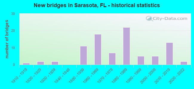
- New bridges - historical statistics
- 11910-1919
- 21920-1929
- 21930-1939
- 111950-1959
- 181960-1969
- 71970-1979
- 221980-1989
- 51990-1999
- 52000-2009
- 132010-2019
- 22020-2022

- Reconstructed bridges - Historical Statistics
- 21950-1959
- 21960-1969
- 31970-1979
- 11980-1989
- 91990-1999
- 02000-2009
- 12010-2019


- Bridge Condition - Deck
- 11.3%Very good
- 50.9%Good
- 32.1%Satisfactory
- 5.7%Fair

- Bridge Condition - Superstructure
- 3.7%Excellent
- 5.6%Very good
- 70.4%Good
- 16.7%Satisfactory
- 3.7%Fair

- Bridge Condition - Substructure
- 3.7%Excellent
- 9.3%Very good
- 75.9%Good
- 11.1%Satisfactory

- Bridge Condition - Channel
- 22.7%Excellent
- 9.1%Very good
- 54.5%Good
- 13.6%Satisfactory

- Bridge Condition - Culverts
- 12.5%Very good
- 66.7%Good
- 20.8%Satisfactory
Find on map >> Show street view
Structure Number: 130003, Location: 0.6MI N/O SR-684 (Lat: 27.473411, Lng: -82.575364), Route carried "on" structure: US 41, Year Built: 1957, Status: Open, Structure Length: 0.88m (2.89ft), Average Daily Traffic: 28,000 (year 2020), Truck Traffic: 4%, Average Future Daily Traffic: 48,580 (year 2042), Design Load: HS 20, Features Intersected: WARES CREEK
Minimum Vertical Clearance: 30+ m (98+ ft), Kilometerpoint: 9.725, Lanes on structure: 5, Base Highway Network: Yes, Owner: State Highway Agency, Approaching Roadway Width: 21.4m (70.2ft), Skew: 29 degrees, Material/Design: Concrete, Design/Construction: Culvert, Number Of Spans In Main Unit: 3, Length of Maximum Span: 2.7m (8.9ft)
Condition: Channel: Good, Culverts: Good, Operating Rating: 53.5 metric tons, Method Used To Determine Operating Rating: Load Factor (LF), Inventory Rating: 31.8 metric tons, Method Used To Determine Inventory Rating: Load Factor (LF), Structural Evaluation: Better than present minimum criteria, Waterway Adequacy: Better than present minimum criteria, Approach Roadway Alignment: Equal to present desirable criteria, Designated Inspection Frequency: Every 24 months, Inspection Date: April 2021
Find on map >> Show street view
Structure Number: 130005, Location: 1.0MI NORTH OF JCT US19 (Lat: 27.563883, Lng: -82.552478), Route carried "on" structure: US 41, Year Built: 1967, Status: Open, Structure Length: 6.96m (22.83ft), Average Daily Traffic: 15,000 (year 2020), Truck Traffic: 12%, Average Future Daily Traffic: 26,025 (year 2042), Design Load: H 10, Features Intersected: CSX RAILROAD
Minimum Vertical Clearance: 30+ m (98+ ft), Kilometerpoint: 5.454, Lanes on structure: 2, Base Highway Network: Yes, Owner: State Highway Agency, Approaching Roadway Width: 8.5m (27.9ft), Skew: 5 degrees, Material/Design: Prestressed concrete, Design/Construction: Stringer/Multi-beam, Number Of Spans In Main Unit: 3, Length of Maximum Span: 23.4m (76.8ft), Curb or Sidewalk Widths: Left: 0.5m (1.6ft), Right: 0.5m (1.6ft), Curb-To-Curb Width: 9.1m (29.9ft), Out-to-Out Width: 10.9m (35.8ft)
Condition: Deck: Good, Superstructure: Good, Substructure: Good, Operating Rating: 62.6 metric tons, Method Used To Determine Operating Rating: Allowable Stress (AS), Inventory Rating: 54.4 metric tons, Method Used To Determine Inventory Rating: Allowable Stress (AS), Structural Evaluation: Better than present minimum criteria, Deck Geometry: Meets minimum limits, Underclear: Somewhat better than minimum adequacy, Approach Roadway Alignment: Better than present minimum criteria, Designated Inspection Frequency: Every 24 months, Inspection Date: November 2021, Deck Structure Type: Concrete Cast-file-Place
Find on map >> Show street view
Structure Number: 130008, Location: 0.2MI NORTH OF US-301 (Lat: 27.524261, Lng: -82.561400), Route carried "on" structure: US 41, Year Built: 1965, Year Reconstructed: 2001, Status: Open, Structure Length: 4.30m (14.11ft), Average Daily Traffic: 39,000 (year 2020), Truck Traffic: 6%, Average Future Daily Traffic: 67,665 (year 2042), Design Load: HS 20+Mod, Features Intersected: CSX RR
Minimum Vertical Clearance: 30+ m (98+ ft), Kilometerpoint: 6.857, Lanes on structure: 5, Base Highway Network: Yes, Owner: State Highway Agency, Approaching Roadway Width: 24.7m (81.0ft), Skew: 24 degrees, Material/Design: Prestressed concrete, Design/Construction: Stringer/Multi-beam, Number Of Spans In Main Unit: 3, Length of Maximum Span: 14.4m (47.2ft), Curb-To-Curb Width: 24.3m (79.7ft), Out-to-Out Width: 25.5m (83.7ft)
Condition: Deck: Good, Superstructure: Good, Substructure: Good, Operating Rating: 42.7 metric tons, Method Used To Determine Operating Rating: Load and Resistance Factor (LRFR), Inventory Rating: 33.0 metric tons, Method Used To Determine Inventory Rating: Load and Resistance Factor (LRFR), Structural Evaluation: Better than present minimum criteria, Deck Geometry: Superior to present desirable criteria, Underclear: Equal to present minimum criteria, Approach Roadway Alignment: Better than present minimum criteria, Designated Inspection Frequency: Every 24 months, Inspection Date: November 2021, Deck Structure Type: Concrete Cast-file-Place
Find on map >> Show street view
Structure Number: 130009, Location: 1.3MI NORTH OF JCT US 301 (Lat: 27.539453, Lng: -82.563792), Route carried "on" structure: US 41, Year Built: 1964, Year Reconstructed: 2001, Status: Open, Structure Length: 10.77m (35.33ft), Average Daily Traffic: 31,000 (year 2020), Truck Traffic: 9%, Average Future Daily Traffic: 53,785 (year 2042), Design Load: HS 20+Mod, Features Intersected: CSX RR & BUS US-41 RAMP
Minimum Vertical Clearance: 30+ m (98+ ft), Kilometerpoint: 8.597, Lanes on structure: 4, Lanes under structure: 3, Base Highway Network: Yes, Owner: State Highway Agency, Approaching Roadway Width: 18.8m (61.7ft), Skew: 25 degrees, Material/Design: Prestressed concrete, Design/Construction: Stringer/Multi-beam, Number Of Spans In Main Unit: 5, Length of Maximum Span: 27.0m (88.6ft), Curb-To-Curb Width: 21.8m (71.5ft), Out-to-Out Width: 23.6m (77.4ft)
Condition: Deck: Satisfactory, Superstructure: Good, Substructure: Good, Operating Rating: 45.7 metric tons, Method Used To Determine Operating Rating: Load and Resistance Factor (LRFR), Inventory Rating: 35.3 metric tons, Method Used To Determine Inventory Rating: Load and Resistance Factor (LRFR), Structural Evaluation: Better than present minimum criteria, Deck Geometry: Superior to present desirable criteria, Underclear: Somewhat better than minimum adequacy, Approach Roadway Alignment: Better than present minimum criteria, Designated Inspection Frequency: Every 24 months, Inspection Date: November 2021, Deck Structure Type: Concrete Cast-file-Place
Find on map >> Show street view
Structure Number: 130028, Location: 0.1MI NORTH OF I-275 (Lat: 27.588250, Lng: -82.540333), Route carried "on" structure: US 41, Year Built: 1967, Year Reconstructed: 1982, Status: Open, Structure Length: 4.46m (14.63ft), Average Daily Traffic: 6,400 (year 2020), Truck Traffic: 13%, Average Future Daily Traffic: 11,104 (year 2042), Design Load: HS 20, Features Intersected: FROG CREEK
Minimum Vertical Clearance: 30+ m (98+ ft), Kilometerpoint: 8.678, Lanes on structure: 3, Base Highway Network: Yes, Owner: State Highway Agency, Approaching Roadway Width: 12.8m (42.0ft), Skew: 3 degrees, Material/Design: Prestressed concrete, Design/Construction: Stringer/Multi-beam, Number Of Spans In Main Unit: 3, Length of Maximum Span: 14.9m (48.9ft), Curb-To-Curb Width: 17.4m (57.1ft), Out-to-Out Width: 18.2m (59.7ft)
Condition: Deck: Satisfactory, Superstructure: Good, Substructure: Good, Channel: Good, Operating Rating: 67.1 metric tons, Method Used To Determine Operating Rating: Allowable Stress (AS), Inventory Rating: 59.9 metric tons, Method Used To Determine Inventory Rating: Allowable Stress (AS), Structural Evaluation: Better than present minimum criteria, Deck Geometry: Superior to present desirable criteria, Waterway Adequacy: Equal to present desirable criteria, Approach Roadway Alignment: Equal to present desirable criteria, Designated Inspection Frequency: Every 24 months, Inspection Date: November 2021, Deck Structure Type: Concrete Cast-file-Place
Find on map >> Show street view
Structure Number: 130029, Location: 0.1MI NORTH OF I-275 (Lat: 27.588117, Lng: -82.540050), Route carried "on" structure: US 41, Year Built: 1967, Year Reconstructed: 1984, Status: Open, Structure Length: 4.46m (14.63ft), Average Daily Traffic: 6,400 (year 2020), Truck Traffic: 13%, Average Future Daily Traffic: 11,104 (year 2042), Design Load: HS 20, Features Intersected: FROG CREEK
Minimum Vertical Clearance: 30+ m (98+ ft), Kilometerpoint: 8.668, Lanes on structure: 3, Base Highway Network: Yes, Owner: State Highway Agency, Approaching Roadway Width: 15.6m (51.2ft), Skew: 3 degrees, Material/Design: Prestressed concrete, Design/Construction: Stringer/Multi-beam, Number Of Spans In Main Unit: 3, Length of Maximum Span: 14.9m (48.9ft), Curb-To-Curb Width: 19.9m (65.3ft), Out-to-Out Width: 20.5m (67.3ft)
Condition: Deck: Good, Superstructure: Good, Substructure: Good, Channel: Good, Operating Rating: 67.1 metric tons, Method Used To Determine Operating Rating: Allowable Stress (AS), Inventory Rating: 59.9 metric tons, Method Used To Determine Inventory Rating: Allowable Stress (AS), Structural Evaluation: Better than present minimum criteria, Deck Geometry: Superior to present desirable criteria, Waterway Adequacy: Equal to present desirable criteria, Approach Roadway Alignment: Equal to present desirable criteria, Designated Inspection Frequency: Every 24 months, Inspection Date: November 2021, Deck Structure Type: Concrete Cast-file-Place
Find on map >> Show street view
Structure Number: 130043, Location: 984 FT S OF SR-684 (Lat: 27.459069, Lng: -82.575358), Route carried "on" structure: US 41, Year Built: 1959, Status: Open, Structure Length: 0.62m (2.03ft), Average Daily Traffic: 42,500 (year 2020), Truck Traffic: 4%, Average Future Daily Traffic: 73,738 (year 2042), Design Load: H 15, Features Intersected: CEDAR HAMMOCK CANAL
Minimum Vertical Clearance: 30+ m (98+ ft), Kilometerpoint: 8.137, Lanes on structure: 7, Base Highway Network: Yes, Owner: State Highway Agency, Approaching Roadway Width: 24.4m (80.1ft), Skew: 3 degrees, Material/Design: Concrete, Design/Construction: Culvert, Number Of Spans In Main Unit: 2, Length of Maximum Span: 3.1m (10.2ft)
Condition: Channel: Good, Culverts: Good, Operating Rating: 80.6 metric tons, Method Used To Determine Operating Rating: Load Factor (LF), Inventory Rating: 48.4 metric tons, Method Used To Determine Inventory Rating: Load Factor (LF), Structural Evaluation: Better than present minimum criteria, Waterway Adequacy: Equal to present desirable criteria, Approach Roadway Alignment: Equal to present desirable criteria, Designated Inspection Frequency: Every 24 months, Inspection Date: April 2021
Find on map >> Show street view
Structure Number: 130054, Location: 0.7MI EAST OF SR-789 (Lat: 27.496661, Lng: -82.694794), Route carried "on" structure: State highway 64, Year Built: 1957, Status: Open, Structure Length: 95.19m (312.30ft), Average Daily Traffic: 17,000 (year 2021), Truck Traffic: 5%, Average Future Daily Traffic: 21,250 (year 2041), Design Load: HS 15, Features Intersected: SARASOTA PASS
Minimum Vertical Clearance: 5.55m (18.21ft), Kilometerpoint: 1.123, Lanes on structure: 2, Owner: State Highway Agency, Approaching Roadway Width: 9.8m (32.2ft), Navigation Control: Yes ( Vertical Clearance: 7.6m (24.9ft), Horizontal Clearance: 27.4m (89.9ft)), Material/Design: Steel, Design/Construction: Movable - Bascule, Number Of Spans In Main Unit: 1, Number Of Approach Spans: 62, Length of Maximum Span: 49.5m (162.4ft), Curb or Sidewalk Widths: Left: 1.5m (4.9ft), Right: 1.5m (4.9ft), Curb-To-Curb Width: 7.3m (24.0ft), Out-to-Out Width: 11.3m (37.1ft)
Condition: Deck: Satisfactory, Superstructure: Satisfactory, Substructure: Satisfactory, Channel: Satisfactory, Operating Rating: 40.8 metric tons, Method Used To Determine Operating Rating: Load Factor (LF), Inventory Rating: 24.5 metric tons, Method Used To Determine Inventory Rating: Load Factor (LF), Structural Evaluation: Equal to present minimum criteria, Deck Geometry: High priority of replacement, Waterway Adequacy: Equal to present desirable criteria, Approach Roadway Alignment: Equal to present desirable criteria, Length Of Structure Improvement: 95.19m (312.30ft), Designated Inspection Frequency: Every 24 months, Critical Feature Inspection Frequency: Every 12 months, Underwater Inspection Frequency: Every 24 months, Other Special Inspection Frequency: Every 12 months, Inspection Date: March 2021, Critical Feature Inspection Date: March 2021, Underwater Inspection Date: Febuary 2021, Other Special Inspection Date: March 2021, Bridge Improvement Cost: $11,640,000, Roadway Improvement Cost: $1,293,000, Total Project Cost: $15,560,000, Deck Structure Type: Concrete Cast-file-Place
Find on map >> Show street view
Structure Number: 130082, Location: 800FT SOTUH OF BAY DR (Lat: 27.416306, Lng: -82.574639), Route carried "on" structure: US 41, Year Built: 1977, Status: Open, Structure Length: 4.61m (15.12ft), Average Daily Traffic: 39,500 (year 2020), Truck Traffic: 4%, Average Future Daily Traffic: 68,532 (year 2042), Design Load: HS 20, Features Intersected: BOWLEES CREEK
Minimum Vertical Clearance: 30+ m (98+ ft), Kilometerpoint: 3.360, Lanes on structure: 6, Base Highway Network: Yes, Owner: State Highway Agency, Approaching Roadway Width: 27.6m (90.6ft), Skew: 20 degrees, Material/Design: Prestressed concrete, Design/Construction: Slab, Number Of Spans In Main Unit: 5, Length of Maximum Span: 9.1m (29.9ft), Curb or Sidewalk Widths: Left: 1.5m (4.9ft), Right: 1.5m (4.9ft), Curb-To-Curb Width: 27.6m (90.6ft), Out-to-Out Width: 31.2m (102.4ft)
Condition: Deck: Satisfactory, Superstructure: Satisfactory, Substructure: Good, Channel: Excellent, Operating Rating: 87.1 metric tons, Method Used To Determine Operating Rating: Allowable Stress (AS), Inventory Rating: 69.9 metric tons, Method Used To Determine Inventory Rating: Allowable Stress (AS), Structural Evaluation: Equal to present minimum criteria, Deck Geometry: Better than present minimum criteria, Waterway Adequacy: Equal to present desirable criteria, Approach Roadway Alignment: Equal to present desirable criteria, Designated Inspection Frequency: Every 24 months, Underwater Inspection Frequency: Every 24 months, Inspection Date: April 2021, Underwater Inspection Date: March 2021, Deck Structure Type: Concrete Precast Panels, Wearing Surface/Protective System: Wearing Surface: Integral Concrete
Find on map >> Show street view
Structure Number: 130099, Location: 0.75 MI S OF I-275 (Lat: 27.574450, Lng: -82.541208), Route carried "on" structure: US 41, Year Built: 1953, Year Reconstructed: 1966, Status: Open, Structure Length: 0.68m (2.23ft), Average Daily Traffic: 30,000 (year 2020), Truck Traffic: 12%, Average Future Daily Traffic: 52,050 (year 2042), Design Load: HS 20+Mod, Features Intersected: MCMULLEN CREEK
Minimum Vertical Clearance: 30+ m (98+ ft), Kilometerpoint: 7.158, Lanes on structure: 4, Base Highway Network: Yes, Owner: State Highway Agency, Approaching Roadway Width: 19.3m (63.3ft), Skew: 10 degrees, Material/Design: Concrete, Design/Construction: Culvert, Number Of Spans In Main Unit: 2, Length of Maximum Span: 3.4m (11.2ft)
Condition: Channel: Good, Culverts: Satisfactory, Inventory Rating: 65.0 metric tons, Method Used To Determine Inventory Rating: Load Factor (LF), Structural Evaluation: Equal to present minimum criteria, Waterway Adequacy: Equal to present desirable criteria, Approach Roadway Alignment: Equal to present desirable criteria, Designated Inspection Frequency: Every 24 months, Underwater Inspection Frequency: Every 24 months, Inspection Date: August 2021, Underwater Inspection Date: July 2021
Find on map >> Show street view
Structure Number: 13016, Location: 3.7MI South of SR-70 (Lat: 27.388636, Lng: -82.448644), Route carried "on" structure: Interstate 75, Year Built: 2017, Status: Open, Structure Length: 8.47m (27.79ft), Average Daily Traffic: 65,750 (year 2020), Truck Traffic: 10%, Average Future Daily Traffic: 114,076 (year 2042), Design Load: Greater than HL93, Features Intersected: UNIVERSITY PKWY
Minimum Vertical Clearance: 30+ m (98+ ft), Kilometerpoint: 0.000, Lanes on structure: 3, Lanes under structure: 12, Base Highway Network: Yes, Owner: State Highway Agency, Approaching Roadway Width: 17.7m (58.1ft), Skew: 1 degrees, Material/Design: Prestressed concrete, Design/Construction: Stringer/Multi-beam, Number Of Spans In Main Unit: 2, Length of Maximum Span: 42.4m (139.1ft), Curb-To-Curb Width: 17.7m (58.1ft), Out-to-Out Width: 18.7m (61.4ft)
Condition: Deck: Very good, Superstructure: Good, Substructure: Very good, Operating Rating: 40.2 metric tons, Method Used To Determine Operating Rating: Load and Resistance Factor (LRFR), Inventory Rating: 36.3 metric tons, Method Used To Determine Inventory Rating: Load and Resistance Factor (LRFR), Structural Evaluation: Better than present minimum criteria, Deck Geometry: Better than present minimum criteria, Underclear: Meets minimum limits, Approach Roadway Alignment: Equal to present desirable criteria, Designated Inspection Frequency: Every 24 months, Inspection Date: October 2020, Deck Structure Type: Concrete Cast-file-Place
Find on map >> Show street view
Structure Number: 130161, Location: 3.7MI South of SR-70 (Lat: 27.388631, Lng: -82.449003), Route carried "on" structure: Interstate 75, Year Built: 2016, Status: Open, Structure Length: 8.47m (27.79ft), Average Daily Traffic: 65,750 (year 2020), Truck Traffic: 10%, Average Future Daily Traffic: 114,076 (year 2042), Design Load: HL 93, Features Intersected: UNIVERSITY PKWY
Minimum Vertical Clearance: 30+ m (98+ ft), Kilometerpoint: 0.016, Lanes on structure: 3, Lanes under structure: 12, Base Highway Network: Yes, Owner: State Highway Agency, Approaching Roadway Width: 17.7m (58.1ft), Skew: 1 degrees, Material/Design: Prestressed concrete, Design/Construction: Stringer/Multi-beam, Number Of Spans In Main Unit: 2, Length of Maximum Span: 42.4m (139.1ft), Curb-To-Curb Width: 17.7m (58.1ft), Out-to-Out Width: 18.7m (61.4ft)
Condition: Deck: Very good, Superstructure: Good, Substructure: Very good, Operating Rating: 40.2 metric tons, Method Used To Determine Operating Rating: Load and Resistance Factor (LRFR), Inventory Rating: 36.3 metric tons, Method Used To Determine Inventory Rating: Load and Resistance Factor (LRFR), Structural Evaluation: Better than present minimum criteria, Deck Geometry: Better than present minimum criteria, Underclear: Meets minimum limits, Approach Roadway Alignment: Equal to present desirable criteria, Designated Inspection Frequency: Every 24 months, Inspection Date: October 2020, Deck Structure Type: Concrete Cast-file-Place
Find on map >> Show street view
Structure Number: 170019, Location: 0.5MI S OF US-301 (Lat: 27.324167, Lng: -82.529722), Route carried "on" structure: US 41, Year Built: 1932, Year Reconstructed: 1955, Status: Open, Structure Length: 2.32m (7.61ft), Average Daily Traffic: 59,000 (year 2020), Truck Traffic: 4%, Average Future Daily Traffic: 102,365 (year 2042), Design Load: HS 20+Mod, Features Intersected: HUDSON BAYOU
Minimum Vertical Clearance: 30.45m (99.90ft), Kilometerpoint: 27.397, Lanes on structure: 7, Base Highway Network: Yes, Owner: State Highway Agency, Approaching Roadway Width: 23.1m (75.8ft), Skew: 4 degrees, Material/Design: Concrete, Design/Construction: Tee Beam, Number Of Spans In Main Unit: 3, Length of Maximum Span: 9.8m (32.2ft), Curb or Sidewalk Widths: Left: 1.6m (5.2ft), Right: 1.6m (5.2ft), Curb-To-Curb Width: 23.1m (75.8ft), Out-to-Out Width: 27.0m (88.6ft)
Condition: Deck: Good, Superstructure: Good, Substructure: Satisfactory, Channel: Good, Operating Rating: 58.3 metric tons, Method Used To Determine Operating Rating: Load Factor (LF), Inventory Rating: 35.1 metric tons, Method Used To Determine Inventory Rating: Load Factor (LF), Structural Evaluation: Equal to present minimum criteria, Deck Geometry: High priority of replacement, Waterway Adequacy: Equal to present desirable criteria, Approach Roadway Alignment: Equal to present desirable criteria, Designated Inspection Frequency: Every 24 months, Underwater Inspection Frequency: Every 24 months, Inspection Date: March 2021, Underwater Inspection Date: Febuary 2021, Deck Structure Type: Concrete Cast-file-Place, Wearing Surface/Protective System: Wearing Surface: Bituminous
Find on map >> Show street view
Structure Number: 170022, Location: 1.4 MI W OF US-41 (Lat: 27.324561, Lng: -82.566194), Route carried "on" structure: State highway 789, Year Built: 1958, Status: Open, Structure Length: 30.79m (101.02ft), Average Daily Traffic: 16,000 (year 2020), Truck Traffic: 4%, Average Future Daily Traffic: 27,760 (year 2042), Design Load: H 15, Features Intersected: COON KEY WATERWAY
Minimum Vertical Clearance: 30+ m (98+ ft), Kilometerpoint: 2.255, Lanes on structure: 2, Owner: State Highway Agency, Approaching Roadway Width: 7.3m (24.0ft), Material/Design: Prestressed concrete, Design/Construction: Stringer/Multi-beam, Number Of Spans In Main Unit: 21, Length of Maximum Span: 14.6m (47.9ft), Curb or Sidewalk Widths: Left: 1.5m (4.9ft), Right: 1.5m (4.9ft), Curb-To-Curb Width: 7.3m (24.0ft), Out-to-Out Width: 11.4m (37.4ft)
Condition: Deck: Fair, Superstructure: Satisfactory, Substructure: Satisfactory, Channel: Good, Operating Rating: 47.2 metric tons, Method Used To Determine Operating Rating: Allowable Stress (AS), Inventory Rating: 37.2 metric tons, Method Used To Determine Inventory Rating: Allowable Stress (AS), Structural Evaluation: Equal to present minimum criteria, Deck Geometry: High priority of replacement, Waterway Adequacy: Equal to present desirable criteria, Approach Roadway Alignment: Equal to present desirable criteria, Designated Inspection Frequency: Every 24 months, Underwater Inspection Frequency: Every 24 months, Inspection Date: January 2021, Underwater Inspection Date: December 2020, Deck Structure Type: Concrete Cast-file-Place
Find on map >> Show street view
Structure Number: 170034, Location: 1.5MI SOUTH OF SR-72 (Lat: 27.242631, Lng: -82.508578), Route carried "on" structure: US 41, Year Built: 1963, Status: Open, Structure Length: 0.76m (2.49ft), Average Daily Traffic: 27,637 (year 2020), Truck Traffic: 4%, Average Future Daily Traffic: 47,950 (year 2042), Design Load: HS 20+Mod, Features Intersected: OSCAR CREEK
Minimum Vertical Clearance: 30.45m (99.90ft), Kilometerpoint: 17.637, Lanes on structure: 6, Base Highway Network: Yes, Owner: State Highway Agency, Approaching Roadway Width: 22.9m (75.1ft), Skew: 11 degrees, Material/Design: Concrete, Design/Construction: Culvert, Number Of Spans In Main Unit: 2, Length of Maximum Span: 3.8m (12.5ft)
Condition: Channel: Good, Culverts: Satisfactory, Inventory Rating: 54.2 metric tons, Method Used To Determine Inventory Rating: Load Factor (LF), Structural Evaluation: Equal to present minimum criteria, Waterway Adequacy: Better than present minimum criteria, Approach Roadway Alignment: Better than present minimum criteria, Designated Inspection Frequency: Every 24 months, Inspection Date: March 2021
Find on map >> Show street view
Structure Number: 170035, Location: 0.8MI S OF SR-72 (Lat: 27.251689, Lng: -82.514683), Route carried "on" structure: US 41, Year Built: 1963, Status: Open, Structure Length: 0.76m (2.49ft), Average Daily Traffic: 27,637 (year 2020), Truck Traffic: 4%, Average Future Daily Traffic: 47,950 (year 2042), Design Load: HS 20+Mod, Features Intersected: MATHENY CREEK
Minimum Vertical Clearance: 30.45m (99.90ft), Kilometerpoint: 18.812, Lanes on structure: 7, Base Highway Network: Yes, Owner: State Highway Agency, Approaching Roadway Width: 17.1m (56.1ft), Skew: 20 degrees, Material/Design: Concrete, Design/Construction: Culvert, Number Of Spans In Main Unit: 2, Length of Maximum Span: 3.8m (12.5ft)
Condition: Channel: Good, Culverts: Satisfactory, Inventory Rating: 60.1 metric tons, Method Used To Determine Inventory Rating: Load Factor (LF), Structural Evaluation: Equal to present minimum criteria, Waterway Adequacy: Better than present minimum criteria, Approach Roadway Alignment: Equal to present desirable criteria, Designated Inspection Frequency: Every 24 months, Underwater Inspection Frequency: Every 24 months, Inspection Date: March 2021, Underwater Inspection Date: Febuary 2021
Find on map >> Show street view
Structure Number: 170039, Location: 1.0MI S of SR-773 (Lat: 27.221342, Lng: -82.491292), Route carried "on" structure: US 41, Year Built: 1962, Status: Open, Structure Length: 1.28m (4.20ft), Average Daily Traffic: 14,750 (year 2020), Truck Traffic: 5%, Average Future Daily Traffic: 25,591 (year 2042), Design Load: H 20, Features Intersected: CATFISH CREEK
Minimum Vertical Clearance: 30.45m (99.90ft), Kilometerpoint: 14.651, Lanes on structure: 2, Base Highway Network: Yes, Owner: State Highway Agency, Approaching Roadway Width: 10.7m (35.1ft), Skew: 3 degrees, Material/Design: Concrete, Design/Construction: Slab, Number Of Spans In Main Unit: 2, Length of Maximum Span: 6.4m (21.0ft), Curb or Sidewalk Widths: Left: 0.0m, Right: 1.5m (4.9ft), Curb-To-Curb Width: 10.7m (35.1ft), Out-to-Out Width: 13.5m (44.3ft)
Condition: Deck: Good, Superstructure: Good, Substructure: Good, Channel: Satisfactory, Operating Rating: 59.0 metric tons, Method Used To Determine Operating Rating: Load Factor (LF), Inventory Rating: 35.4 metric tons, Method Used To Determine Inventory Rating: Load Factor (LF), Structural Evaluation: Better than present minimum criteria, Deck Geometry: Somewhat better than minimum adequacy, Waterway Adequacy: Equal to present desirable criteria, Approach Roadway Alignment: Equal to present desirable criteria, Length Of Structure Improvement: 1.28m (4.20ft), Designated Inspection Frequency: Every 24 months, Inspection Date: March 2021, Bridge Improvement Cost: $10,000, Roadway Improvement Cost: $1,000, Total Project Cost: $11,000, Deck Structure Type: Concrete Cast-file-Place, Wearing Surface/Protective System: Wearing Surface: Bituminous
Find on map >> Show street view
Structure Number: 170045, Location: 200FT. N OF VENICE AVE. (Lat: 27.100958, Lng: -82.433575), Route carried "on" structure: Bypass US 41, Year Built: 1966, Year Reconstructed: 2017, Status: Open, Structure Length: 0.99m (3.25ft), Average Daily Traffic: 31,500 (year 2020), Truck Traffic: 5%, Average Future Daily Traffic: 54,652 (year 2042), Design Load: HL 93, Features Intersected: HATCHETT CREEK
Minimum Vertical Clearance: 30.45m (99.90ft), Kilometerpoint: 3.351, Lanes on structure: 9, Base Highway Network: Yes, Owner: State Highway Agency, Approaching Roadway Width: 24.2m (79.4ft), Skew: 21 degrees, Material/Design: Concrete, Design/Construction: Culvert, Number Of Spans In Main Unit: 3, Length of Maximum Span: 3.3m (10.8ft)
Condition: Channel: Good, Culverts: Satisfactory, Operating Rating: 83.3 metric tons, Method Used To Determine Operating Rating: Load and Resistance Factor (LRFR), Inventory Rating: 64.3 metric tons, Method Used To Determine Inventory Rating: Load and Resistance Factor (LRFR), Structural Evaluation: Equal to present minimum criteria, Waterway Adequacy: Equal to present desirable criteria, Approach Roadway Alignment: Equal to present desirable criteria, Designated Inspection Frequency: Every 24 months, Underwater Inspection Frequency: Every 24 months, Inspection Date: March 2021, Underwater Inspection Date: Febuary 2021
Find on map >> Show street view
Structure Number: 170059, Location: 3.1 MI WEST OF US-41 (Lat: 27.284967, Lng: -82.555281), Route carried "on" structure: State highway 758, Year Built: 1966, Status: Open, Structure Length: 2.74m (8.99ft), Average Daily Traffic: 6,100 (year 2020), Truck Traffic: 4%, Average Future Daily Traffic: 10,584 (year 2042), Design Load: HL 93, Features Intersected: GRAND CANAL
Minimum Vertical Clearance: 30+ m (98+ ft), Kilometerpoint: 4.255, Lanes on structure: 2, Owner: State Highway Agency, Approaching Roadway Width: 10.6m (34.8ft), Skew: 1 degrees, Material/Design: Prestressed concrete, Design/Construction: Stringer/Multi-beam, Number Of Spans In Main Unit: 3, Length of Maximum Span: 15.2m (49.9ft), Curb-To-Curb Width: 8.5m (27.9ft), Out-to-Out Width: 10.4m (34.1ft)
Condition: Deck: Satisfactory, Superstructure: Good, Substructure: Good, Channel: Excellent, Operating Rating: 29.4 metric tons, Method Used To Determine Operating Rating: Load and Resistance Factor (LRFR), Inventory Rating: 22.7 metric tons, Method Used To Determine Inventory Rating: Load and Resistance Factor (LRFR), Structural Evaluation: Somewhat better than minimum adequacy, Deck Geometry: High priority of replacement, Waterway Adequacy: Equal to present desirable criteria, Approach Roadway Alignment: Equal to present desirable criteria, Designated Inspection Frequency: Every 24 months, Inspection Date: January 2021, Deck Structure Type: Concrete Cast-file-Place
Find on map >> Show street view
Structure Number: 170068, Location: 0.3MI W OF US-301 (Lat: 27.328528, Lng: -82.535917), Route carried "on" structure: US 41, Year Built: 1958, Status: Open, Structure Length: 3.66m (12.01ft), Average Daily Traffic: 31,000 (year 2020), Truck Traffic: 4%, Average Future Daily Traffic: 53,785 (year 2042), Design Load: HS 20, Features Intersected: HUDSON BAYOU
Minimum Vertical Clearance: 30.45m (99.90ft), Kilometerpoint: 28.482, Lanes on structure: 6, Base Highway Network: Yes, Owner: State Highway Agency, Approaching Roadway Width: 20.7m (67.9ft), Skew: 20 degrees, Material/Design: Concrete, Design/Construction: Slab, Number Of Spans In Main Unit: 6, Length of Maximum Span: 6.1m (20.0ft), Curb or Sidewalk Widths: Left: 1.6m (5.2ft), Right: 1.6m (5.2ft), Curb-To-Curb Width: 20.7m (67.9ft), Out-to-Out Width: 29.9m (98.1ft)
Condition: Deck: Satisfactory, Superstructure: Satisfactory, Substructure: Good, Channel: Good, Operating Rating: 50.8 metric tons, Method Used To Determine Operating Rating: Load Factor (LF), Inventory Rating: 29.9 metric tons, Method Used To Determine Inventory Rating: Load Factor (LF), Structural Evaluation: Equal to present minimum criteria, Deck Geometry: High priority of replacement, Waterway Adequacy: Equal to present desirable criteria, Approach Roadway Alignment: Equal to present desirable criteria, Designated Inspection Frequency: Every 24 months, Underwater Inspection Frequency: Every 24 months, Inspection Date: March 2021, Underwater Inspection Date: Febuary 2021, Deck Structure Type: Concrete Cast-file-Place
Find on map >> Show street view
Structure Number: 170069, Location: BENEVA ROAD & SR 780 (Lat: 27.337108, Lng: -82.497125), Route carried "on" structure: State highway 780, Year Built: 1974, Status: Open, Structure Length: 0.92m (3.02ft), Average Daily Traffic: 45,000 (year 2020), Truck Traffic: 6%, Average Future Daily Traffic: 78,075 (year 2042), Design Load: H 20, Features Intersected: PHILLIPPI CREEK
Minimum Vertical Clearance: 6.37m (20.90ft), Kilometerpoint: 3.492, Lanes on structure: 7, Base Highway Network: Yes, Owner: State Highway Agency, Approaching Roadway Width: 53.9m (176.8ft), Skew: 22 degrees, Material/Design: Concrete, Design/Construction: Culvert, Number Of Spans In Main Unit: 2, Length of Maximum Span: 4.4m (14.4ft)
Condition: Channel: Satisfactory, Culverts: Good, Inventory Rating: 57.2 metric tons, Method Used To Determine Inventory Rating: Load Factor (LF), Structural Evaluation: Better than present minimum criteria, Waterway Adequacy: Equal to present desirable criteria, Approach Roadway Alignment: Equal to present desirable criteria, Designated Inspection Frequency: Every 24 months, Inspection Date: January 2021
Find on map >> Show street view
Structure Number: 170085, Location: 2.0MI S OF BEE RIDGE RD. (Lat: 27.269431, Lng: -82.449156), Route carried "on" structure: Interstate 75, Year Built: 1980, Year Reconstructed: 2001, Status: Open, Structure Length: 7.35m (24.11ft), Average Daily Traffic: 51,330 (year 2020), Truck Traffic: 11%, Average Future Daily Traffic: 89,057 (year 2042), Design Load: HS 20+Mod, Features Intersected: SR-72 (CLARK ROAD)
Minimum Vertical Clearance: 30+ m (98+ ft), Kilometerpoint: 55.353, Lanes on structure: 3, Lanes under structure: 8, Base Highway Network: Yes, Owner: State Highway Agency, Approaching Roadway Width: 17.0m (55.8ft), Material/Design: Prestressed concrete, Design/Construction: Stringer/Multi-beam, Number Of Spans In Main Unit: 4, Length of Maximum Span: 26.8m (87.9ft), Curb-To-Curb Width: 17.0m (55.8ft), Out-to-Out Width: 18.1m (59.4ft)
Condition: Deck: Good, Superstructure: Good, Substructure: Good, Operating Rating: 55.3 metric tons, Method Used To Determine Operating Rating: Allowable Stress (AS), Inventory Rating: 48.1 metric tons, Method Used To Determine Inventory Rating: Allowable Stress (AS), Structural Evaluation: Better than present minimum criteria, Deck Geometry: Equal to present minimum criteria, Underclear: Better than present minimum criteria, Approach Roadway Alignment: Equal to present desirable criteria, Designated Inspection Frequency: Every 24 months, Inspection Date: Febuary 2022, Deck Structure Type: Concrete Cast-file-Place
Find on map >> Show street view
Structure Number: 170086, Location: 2.0MI S OF BEE RIDGE RD. (Lat: 27.269417, Lng: -82.448767), Route carried "on" structure: Interstate 75, Year Built: 1980, Year Reconstructed: 2001, Status: Open, Structure Length: 7.35m (24.11ft), Average Daily Traffic: 49,000 (year 2020), Truck Traffic: 11%, Average Future Daily Traffic: 85,015 (year 2042), Design Load: HS 20+Mod, Features Intersected: SR-72 (CLARK ROAD)
Minimum Vertical Clearance: 30+ m (98+ ft), Kilometerpoint: 55.292, Lanes on structure: 3, Lanes under structure: 8, Base Highway Network: Yes, Owner: State Highway Agency, Approaching Roadway Width: 17.0m (55.8ft), Material/Design: Prestressed concrete, Design/Construction: Stringer/Multi-beam, Number Of Spans In Main Unit: 4, Length of Maximum Span: 26.8m (87.9ft), Curb-To-Curb Width: 17.0m (55.8ft), Out-to-Out Width: 18.1m (59.4ft)
Condition: Deck: Good, Superstructure: Good, Substructure: Good, Operating Rating: 55.3 metric tons, Method Used To Determine Operating Rating: Allowable Stress (AS), Inventory Rating: 48.1 metric tons, Method Used To Determine Inventory Rating: Allowable Stress (AS), Structural Evaluation: Better than present minimum criteria, Deck Geometry: Equal to present minimum criteria, Underclear: Better than present minimum criteria, Approach Roadway Alignment: Equal to present desirable criteria, Designated Inspection Frequency: Every 24 months, Inspection Date: Febuary 2022, Deck Structure Type: Concrete Cast-file-Place
Find on map >> Show street view
Structure Number: 170099, Location: 1.5 MI NORTH OF US-41 (Lat: 27.168181, Lng: -82.456264), Route carried "on" structure: State highway 681, Year Built: 1981, Status: Open, Structure Length: 10.91m (35.79ft), Average Daily Traffic: 6,800 (year 2020), Truck Traffic: 10%, Average Future Daily Traffic: 11,798 (year 2042), Design Load: HS 20, Features Intersected: ABANDONED CSX RR
Minimum Vertical Clearance: 30+ m (98+ ft), Kilometerpoint: 2.353, Lanes on structure: 2, Base Highway Network: Yes, Owner: State Highway Agency, Approaching Roadway Width: 11.6m (38.1ft), Skew: 4 degrees, Material/Design: Prestressed concrete, Design/Construction: Stringer/Multi-beam, Number Of Spans In Main Unit: 4, Length of Maximum Span: 29.9m (98.1ft), Curb-To-Curb Width: 12.2m (40.0ft), Out-to-Out Width: 13.0m (42.7ft)
Condition: Deck: Good, Superstructure: Good, Substructure: Good, Operating Rating: 52.6 metric tons, Method Used To Determine Operating Rating: Allowable Stress (AS), Inventory Rating: 32.7 metric tons, Method Used To Determine Inventory Rating: Allowable Stress (AS), Structural Evaluation: Better than present minimum criteria, Deck Geometry: Better than present minimum criteria, Approach Roadway Alignment: Equal to present desirable criteria, Designated Inspection Frequency: Every 24 months, Inspection Date: December 2021, Deck Structure Type: Concrete Precast Panels
Find on map >> Show street view
Structure Number: 170105, Location: 9.7 MI S OF SR-72 (Lat: 27.137547, Lng: -82.410564), Route carried "on" structure: County highway , Year Built: 1980, Year Reconstructed: 1995, Status: Open, Structure Length: 5.52m (18.11ft), Average Daily Traffic: 10,250 (year 2020), Truck Traffic: 7%, Average Future Daily Traffic: 17,784 (year 2042), Design Load: HL 93, Features Intersected: I-75 SB (SR-93), Facility Carried by Structure: LAUREL RD
Minimum Vertical Clearance: 30+ m (98+ ft), Kilometerpoint: 2.248, Lanes on structure: 5, Lanes under structure: 3, Owner: State Highway Agency, Approaching Roadway Width: 27.3m (89.6ft), Skew: 23 degrees, Material/Design: Prestressed concrete, Design/Construction: Stringer/Multi-beam, Number Of Spans In Main Unit: 3, Length of Maximum Span: 33.2m (108.9ft), Curb-To-Curb Width: 27.3m (89.6ft), Out-to-Out Width: 28.4m (93.2ft)
Condition: Deck: Good, Superstructure: Satisfactory, Substructure: Good, Operating Rating: 49.4 metric tons, Method Used To Determine Operating Rating: Load and Resistance Factor (LRFR), Inventory Rating: 42.8 metric tons, Method Used To Determine Inventory Rating: Load and Resistance Factor (LRFR), Structural Evaluation: Equal to present minimum criteria, Deck Geometry: Superior to present desirable criteria, Underclear: Somewhat better than minimum adequacy, Approach Roadway Alignment: Equal to present desirable criteria, Designated Inspection Frequency: Every 24 months, Inspection Date: Febuary 2020, Deck Structure Type: Concrete Cast-file-Place
Find on map >> Show street view
Structure Number: 170106, Location: 9.7 MI S OF SR-72 (Lat: 27.137450, Lng: -82.407197), Route carried "on" structure: County highway , Year Built: 1980, Year Reconstructed: 1996, Status: Open, Structure Length: 5.49m (18.01ft), Average Daily Traffic: 10,250 (year 2020), Truck Traffic: 7%, Average Future Daily Traffic: 17,784 (year 2042), Design Load: HL 93, Features Intersected: I-75 NB (SR-93), Facility Carried by Structure: LAUREL RD
Minimum Vertical Clearance: 30+ m (98+ ft), Kilometerpoint: 2.577, Lanes on structure: 6, Lanes under structure: 3, Owner: State Highway Agency, Approaching Roadway Width: 27.4m (89.9ft), Skew: 22 degrees, Material/Design: Prestressed concrete, Design/Construction: Stringer/Multi-beam, Number Of Spans In Main Unit: 3, Length of Maximum Span: 32.9m (107.9ft), Curb-To-Curb Width: 27.4m (89.9ft), Out-to-Out Width: 28.3m (92.8ft)
Condition: Deck: Good, Superstructure: Good, Substructure: Good, Operating Rating: 43.5 metric tons, Method Used To Determine Operating Rating: Load and Resistance Factor (LRFR), Inventory Rating: 38.2 metric tons, Method Used To Determine Inventory Rating: Load and Resistance Factor (LRFR), Structural Evaluation: Better than present minimum criteria, Deck Geometry: Better than present minimum criteria, Underclear: Somewhat better than minimum adequacy, Approach Roadway Alignment: Equal to present desirable criteria, Designated Inspection Frequency: Every 24 months, Inspection Date: Febuary 2020, Deck Structure Type: Concrete Cast-file-Place
Find on map >> Show street view
Structure Number: 170107, Location: 2.9 MI S OF SR-681 (Lat: 27.147611, Lng: -82.418500), Route carried "on" structure: County highway , Year Built: 1980, Year Reconstructed: 1996, Status: Open, Structure Length: 10.06m (33.01ft), Average Daily Traffic: 12,200 (year 2021), Truck Traffic: 3%, Average Future Daily Traffic: 21,167 (year 2042), Design Load: HS 20, Features Intersected: SALT CREEK, Facility Carried by Structure: HONORE AVE
Minimum Vertical Clearance: 30+ m (98+ ft), Kilometerpoint: 0.000, Lanes on structure: 2, Owner: County Highway Agency, Approaching Roadway Width: 9.4m (30.8ft), Material/Design: Prestressed concrete, Design/Construction: Stringer/Multi-beam, Number Of Spans In Main Unit: 5, Length of Maximum Span: 20.1m (65.9ft), Curb or Sidewalk Widths: Left: 2.4m (7.9ft), Right: 0.0m, Curb-To-Curb Width: 9.3m (30.5ft), Out-to-Out Width: 13.1m (43.0ft)
Condition: Deck: Good, Superstructure: Good, Substructure: Good, Channel: Good, Operating Rating: 62.1 metric tons, Method Used To Determine Operating Rating: Load Factor (LF), Inventory Rating: 33.9 metric tons, Method Used To Determine Inventory Rating: Load Factor (LF), Structural Evaluation: Better than present minimum criteria, Deck Geometry: Meets minimum limits, Waterway Adequacy: Equal to present desirable criteria, Approach Roadway Alignment: Equal to present desirable criteria, Designated Inspection Frequency: Every 24 months, Inspection Date: December 2021, Deck Structure Type: Concrete Cast-file-Place
Find on map >> Show street view
Structure Number: 17012, Location: 0.75 MI S OF NEW PASS (Lat: 27.322550, Lng: -82.580147), Route carried "on" structure: State highway 789, Year Built: 1976, Status: Open, Structure Length: 3.66m (12.01ft), Average Daily Traffic: 9,850 (year 2020), Truck Traffic: 4%, Average Future Daily Traffic: 17,090 (year 2042), Design Load: HS 20+Mod, Features Intersected: ST ARMANDS KEY WATERWAY, Facility Carried by Structure: JOHN RINGLING PKWY
Minimum Vertical Clearance: 30+ m (98+ ft), Kilometerpoint: 4.160, Lanes on structure: 2, Owner: State Highway Agency, Approaching Roadway Width: 9.2m (30.2ft), Material/Design: Concrete continuous, Design/Construction: Slab, Number Of Spans In Main Unit: 4, Length of Maximum Span: 10.1m (33.1ft), Curb or Sidewalk Widths: Left: 0.9m (3.0ft), Right: 0.0m, Curb-To-Curb Width: 9.2m (30.2ft), Out-to-Out Width: 11.0m (36.1ft)
Condition: Deck: Satisfactory, Superstructure: Satisfactory, Substructure: Good, Channel: Good, Operating Rating: 56.2 metric tons, Method Used To Determine Operating Rating: Load Factor (LF), Inventory Rating: 33.6 metric tons, Method Used To Determine Inventory Rating: Load Factor (LF), Structural Evaluation: Equal to present minimum criteria, Deck Geometry: Meets minimum limits, Waterway Adequacy: Equal to present desirable criteria, Approach Roadway Alignment: Equal to present desirable criteria, Designated Inspection Frequency: Every 24 months, Underwater Inspection Frequency: Every 24 months, Inspection Date: January 2021, Underwater Inspection Date: December 2020, Deck Structure Type: Concrete Cast-file-Place
Find on map >> Show street view
Structure Number: 170141, Location: 0.75MI SOUTH OF NEW PASS (Lat: 27.322592, Lng: -82.579969), Route carried "on" structure: State highway 789, Year Built: 1976, Status: Open, Structure Length: 3.66m (12.01ft), Average Daily Traffic: 9,850 (year 2020), Truck Traffic: 4%, Average Future Daily Traffic: 17,090 (year 2042), Design Load: HS 20+Mod, Features Intersected: ST ARMANDS KEY WATERWAY, Facility Carried by Structure: JOHN RINGLING PKWY
Minimum Vertical Clearance: 30+ m (98+ ft), Kilometerpoint: 4.160, Lanes on structure: 1, Owner: State Highway Agency, Approaching Roadway Width: 9.2m (30.2ft), Material/Design: Concrete continuous, Design/Construction: Slab, Number Of Spans In Main Unit: 4, Length of Maximum Span: 10.1m (33.1ft), Curb or Sidewalk Widths: Left: 0.0m, Right: 0.9m (3.0ft), Curb-To-Curb Width: 9.2m (30.2ft), Out-to-Out Width: 11.0m (36.1ft)
Condition: Deck: Satisfactory, Superstructure: Satisfactory, Substructure: Good, Channel: Good, Operating Rating: 54.2 metric tons, Method Used To Determine Operating Rating: Load Factor (LF), Inventory Rating: 32.4 metric tons, Method Used To Determine Inventory Rating: Load Factor (LF), Structural Evaluation: Equal to present minimum criteria, Deck Geometry: High priority of corrective action, Waterway Adequacy: Equal to present desirable criteria, Approach Roadway Alignment: Equal to present desirable criteria, Designated Inspection Frequency: Every 24 months, Underwater Inspection Frequency: Every 24 months, Inspection Date: January 2021, Underwater Inspection Date: December 2020, Deck Structure Type: Concrete Cast-file-Place
Find on map >> Show street view
Structure Number: 170145, Location: 2.7MI S OF FRUITVILLE RD. (Lat: 27.298825, Lng: -82.448203), Route carried "on" structure: Interstate 75, Year Built: 1981, Year Reconstructed: 2001, Status: Open, Structure Length: 5.82m (19.09ft), Average Daily Traffic: 61,500 (year 2020), Truck Traffic: 9%, Average Future Daily Traffic: 106,702 (year 2042), Design Load: HS 20+Mod, Features Intersected: BEE RIDGE ROAD
Minimum Vertical Clearance: 30+ m (98+ ft), Kilometerpoint: 58.619, Lanes on structure: 3, Lanes under structure: 6, Base Highway Network: Yes, Owner: State Highway Agency, Approaching Roadway Width: 17.1m (56.1ft), Material/Design: Prestressed concrete, Design/Construction: Stringer/Multi-beam, Number Of Spans In Main Unit: 3, Length of Maximum Span: 36.3m (119.1ft), Curb-To-Curb Width: 17.1m (56.1ft), Out-to-Out Width: 18.0m (59.1ft)
Condition: Deck: Satisfactory, Superstructure: Good, Substructure: Good, Operating Rating: 55.9 metric tons, Method Used To Determine Operating Rating: Load Factor (LF), Inventory Rating: 33.5 metric tons, Method Used To Determine Inventory Rating: Load Factor (LF), Structural Evaluation: Better than present minimum criteria, Deck Geometry: Equal to present minimum criteria, Underclear: High priority of corrective action, Approach Roadway Alignment: Equal to present desirable criteria, Designated Inspection Frequency: Every 24 months, Inspection Date: October 2021, Deck Structure Type: Concrete Cast-file-Place
Find on map >> Show street view
Structure Number: 170146, Location: 2.7MI S OF FRUITVILLE RD (Lat: 27.298800, Lng: -82.447831), Route carried "on" structure: Interstate 75, Year Built: 1981, Year Reconstructed: 2001, Status: Open, Structure Length: 5.82m (19.09ft), Average Daily Traffic: 61,500 (year 2020), Truck Traffic: 9%, Average Future Daily Traffic: 106,702 (year 2042), Design Load: HS 20+Mod, Features Intersected: BEE RIDGE ROAD
Minimum Vertical Clearance: 30+ m (98+ ft), Kilometerpoint: 58.553, Lanes on structure: 4, Lanes under structure: 6, Base Highway Network: Yes, Owner: State Highway Agency, Approaching Roadway Width: 17.1m (56.1ft), Material/Design: Prestressed concrete, Design/Construction: Stringer/Multi-beam, Number Of Spans In Main Unit: 3, Length of Maximum Span: 36.3m (119.1ft), Curb-To-Curb Width: 19.7m (64.6ft), Out-to-Out Width: 20.6m (67.6ft)
Condition: Deck: Satisfactory, Superstructure: Good, Substructure: Good, Operating Rating: 87.1 metric tons, Method Used To Determine Operating Rating: Load Factor (LF), Inventory Rating: 52.6 metric tons, Method Used To Determine Inventory Rating: Load Factor (LF), Structural Evaluation: Better than present minimum criteria, Deck Geometry: Equal to present minimum criteria, Underclear: High priority of corrective action, Approach Roadway Alignment: Equal to present desirable criteria, Designated Inspection Frequency: Every 24 months, Inspection Date: October 2021, Deck Structure Type: Concrete Cast-file-Place
Find on map >> Show street view
Structure Number: 170158, Location: 1/4MI E/O LONGBOAT CLUB D (Lat: 27.333019, Lng: -82.581758), Route carried "on" structure: State highway 789, Year Built: 1986, Status: Open, Structure Length: 29.40m (96.46ft), Average Daily Traffic: 18,900 (year 2021), Truck Traffic: 5%, Average Future Daily Traffic: 23,625 (year 2041), Design Load: HS 20+Mod, Features Intersected: NEW PASS
Minimum Vertical Clearance: 5.30m (17.39ft), Kilometerpoint: 0.286, Lanes on structure: 2, Owner: State Highway Agency, Approaching Roadway Width: 17.1m (56.1ft), Navigation Control: Yes ( Vertical Clearance: 6.7m (22.0ft), Horizontal Clearance: 28.0m (91.9ft)), Material/Design: Steel, Design/Construction: Movable - Bascule, Number Of Spans In Main Unit: 1, Number Of Approach Spans: 10, Length of Maximum Span: 35.7m (117.1ft), Curb or Sidewalk Widths: Left: 1.5m (4.9ft), Right: 0.0m, Curb-To-Curb Width: 17.0m (55.8ft), Out-to-Out Width: 19.8m (65.0ft)
Condition: Deck: Good, Superstructure: Good, Substructure: Satisfactory, Channel: Good, Operating Rating: 57.6 metric tons, Method Used To Determine Operating Rating: Load Factor (LF), Inventory Rating: 34.6 metric tons, Method Used To Determine Inventory Rating: Load Factor (LF), Structural Evaluation: Equal to present minimum criteria, Deck Geometry: Superior to present desirable criteria, Waterway Adequacy: Superior to present desirable criteria, Approach Roadway Alignment: Better than present minimum criteria, Designated Inspection Frequency: Every 24 months, Critical Feature Inspection Frequency: Every 5 months, Underwater Inspection Frequency: Every 24 months, Other Special Inspection Frequency: Every 5 months, Inspection Date: Febuary 2020, Critical Feature Inspection Date: September 2021, Underwater Inspection Date: January 2020, Other Special Inspection Date: September 2021, Deck Structure Type: Concrete Cast-file-Place
Find on map >> Show street view
Structure Number: 170159, Location: 0.5MI E OF BENEVA RD. (Lat: 27.337442, Lng: -82.490314), Route carried "on" structure: State highway 780, Year Built: 1989, Status: Open, Structure Length: 0.64m (2.10ft), Average Daily Traffic: 55,000 (year 2019), Truck Traffic: 5%, Average Future Daily Traffic: 95,425 (year 2041), Design Load: HS 20+Mod, Features Intersected: PGA CANAL, Facility Carried by Structure: FRUITVILLE ROAD
Minimum Vertical Clearance: 30.45m (99.90ft), Kilometerpoint: 4.686, Lanes on structure: 7, Base Highway Network: Yes, Owner: State Highway Agency, Approaching Roadway Width: 29.7m (97.4ft), Skew: 2 degrees, Material/Design: Concrete, Design/Construction: Culvert, Number Of Spans In Main Unit: 2, Length of Maximum Span: 2.7m (8.9ft)
Condition: Channel: Satisfactory, Culverts: Good, Structural Evaluation: Better than present minimum criteria, Waterway Adequacy: Superior to present desirable criteria, Approach Roadway Alignment: Equal to present desirable criteria, Designated Inspection Frequency: Every 24 months, Inspection Date: January 2021
Find on map >> Show street view
Structure Number: 170176, Location: 0.5 MI W OF US-41 (SR-45) (Lat: 27.331781, Lng: -82.556447), Route carried "on" structure: State highway 789, Year Built: 2003, Status: Open, Structure Length: 94.39m (309.68ft), Average Daily Traffic: 34,000 (year 2020), Truck Traffic: 4%, Average Future Daily Traffic: 58,990 (year 2042), Design Load: HS 20, Features Intersected: INTRACOASTAL WATERWAY
Minimum Vertical Clearance: 30+ m (98+ ft), Kilometerpoint: 0.447, Lanes on structure: 4, Owner: State Highway Agency, Approaching Roadway Width: 24.0m (78.7ft), Skew: 39 degrees, Navigation Control: Yes ( Vertical Clearance: 18.3m (60.0ft), Horizontal Clearance: 87.5m (287.1ft)), Material/Design: Prestressed concrete continuous, Design/Construction: Segmental Box Girder, Number Of Spans In Main Unit: 11, Length of Maximum Span: 91.5m (300.2ft), Curb or Sidewalk Widths: Left: 3.0m (9.8ft), Right: 3.0m (9.8ft), Curb-To-Curb Width: 24.0m (78.7ft), Out-to-Out Width: 32.4m (106.3ft)
Condition: Deck: Good, Superstructure: Good, Substructure: Very good, Channel: Very good, Operating Rating: 46.6 metric tons, Method Used To Determine Operating Rating: Load Factor (LF), Inventory Rating: 36.7 metric tons, Method Used To Determine Inventory Rating: Load Factor (LF), Structural Evaluation: Better than present minimum criteria, Deck Geometry: Superior to present desirable criteria, Waterway Adequacy: Equal to present desirable criteria, Approach Roadway Alignment: Equal to present desirable criteria, Designated Inspection Frequency: Every 24 months, Underwater Inspection Frequency: Every 24 months, Other Special Inspection Frequency: Every 12 months, Inspection Date: January 2022, Underwater Inspection Date: December 2021, Other Special Inspection Date: January 2022, Deck Structure Type: Other
Find on map >> Show street view
Structure Number: 170187, Location: 4.2Mi. S of SR-72 (Lat: 27.209833, Lng: -82.490222), Route carried "on" structure: US 41, Year Built: 2020, Status: Open, Structure Length: 1.78m (5.84ft), Average Daily Traffic: 17,250 (year 2019), Truck Traffic: 4%, Average Future Daily Traffic: 29,929 (year 2041), Design Load: HL 93, Features Intersected: North Creek
Minimum Vertical Clearance: 30+ m (98+ ft), Kilometerpoint: 13.362, Lanes on structure: 2, Base Highway Network: Yes, Owner: State Highway Agency, Approaching Roadway Width: 12.5m (41.0ft), Material/Design: Concrete, Design/Construction: Slab, Number Of Spans In Main Unit: 2, Length of Maximum Span: 10.7m (35.1ft), Curb or Sidewalk Widths: Left: 0.0m, Right: 1.5m (4.9ft), Curb-To-Curb Width: 12.5m (41.0ft), Out-to-Out Width: 14.8m (48.6ft)
Condition: Deck: Very good, Superstructure: Very good, Substructure: Very good, Channel: Very good, Operating Rating: 70.2 metric tons, Method Used To Determine Operating Rating: Load and Resistance Factor (LRFR), Inventory Rating: 54.2 metric tons, Method Used To Determine Inventory Rating: Load and Resistance Factor (LRFR), Structural Evaluation: Equal to present desirable criteria, Deck Geometry: Better than present minimum criteria, Waterway Adequacy: Equal to present desirable criteria, Approach Roadway Alignment: Equal to present desirable criteria, Designated Inspection Frequency: Every 24 months, Underwater Inspection Frequency: Every 24 months, Inspection Date: December 2020, Underwater Inspection Date: November 2020, Deck Structure Type: Concrete Cast-file-Place, Wearing Surface/Protective System: Wearing Surface: Bituminous
Find on map >> Show street view
Structure Number: 17092, Location: 1.0MI N OF SR-780 (Lat: 27.354861, Lng: -82.547389), Route carried "on" structure: US 41, Year Built: 1923, Year Reconstructed: 1957, Status: Open, Structure Length: 2.68m (8.79ft), Average Daily Traffic: 25,500 (year 2020), Truck Traffic: 4%, Average Future Daily Traffic: 44,242 (year 2042), Design Load: H 15, Features Intersected: WHITAKER BAYOU
Minimum Vertical Clearance: 30+ m (98+ ft), Kilometerpoint: 32.114, Lanes on structure: 4, Base Highway Network: Yes, Owner: State Highway Agency, Approaching Roadway Width: 16.2m (53.1ft), Skew: 20 degrees, Material/Design: Concrete, Design/Construction: Stringer/Multi-beam, Number Of Spans In Main Unit: 3, Length of Maximum Span: 11.6m (38.1ft), Curb or Sidewalk Widths: Left: 1.3m (4.3ft), Right: 1.3m (4.3ft), Curb-To-Curb Width: 16.2m (53.1ft), Out-to-Out Width: 23.6m (77.4ft)
Condition: Deck: Good, Superstructure: Good, Substructure: Good, Channel: Good, Operating Rating: 66.2 metric tons, Method Used To Determine Operating Rating: Load Factor (LF), Inventory Rating: 39.9 metric tons, Method Used To Determine Inventory Rating: Load Factor (LF), Structural Evaluation: Better than present minimum criteria, Deck Geometry: Meets minimum limits, Waterway Adequacy: Equal to present desirable criteria, Approach Roadway Alignment: Equal to present desirable criteria, Designated Inspection Frequency: Every 24 months, Underwater Inspection Frequency: Every 24 months, Inspection Date: March 2021, Underwater Inspection Date: Febuary 2021, Deck Structure Type: Concrete Cast-file-Place, Wearing Surface/Protective System: Wearing Surface: Bituminous
Find on map >> Show street view
Structure Number: 170951, Location: 1.4 MI W OF US-41 (Lat: 27.324306, Lng: -82.566028), Route carried "on" structure: State highway 789, Year Built: 1958, Status: Open, Structure Length: 30.79m (101.02ft), Average Daily Traffic: 16,000 (year 2020), Truck Traffic: 4%, Average Future Daily Traffic: 27,760 (year 2042), Design Load: H 15, Features Intersected: COON KEY WATERWAY
Minimum Vertical Clearance: 30+ m (98+ ft), Kilometerpoint: 2.255, Lanes on structure: 2, Owner: State Highway Agency, Approaching Roadway Width: 7.5m (24.6ft), Material/Design: Prestressed concrete, Design/Construction: Stringer/Multi-beam, Number Of Spans In Main Unit: 21, Length of Maximum Span: 14.6m (47.9ft), Curb or Sidewalk Widths: Left: 1.5m (4.9ft), Right: 1.5m (4.9ft), Curb-To-Curb Width: 7.3m (24.0ft), Out-to-Out Width: 11.4m (37.4ft)
Condition: Deck: Satisfactory, Superstructure: Good, Substructure: Satisfactory, Channel: Good, Operating Rating: 37.2 metric tons, Method Used To Determine Operating Rating: Allowable Stress (AS), Inventory Rating: 29.9 metric tons, Method Used To Determine Inventory Rating: Allowable Stress (AS), Structural Evaluation: Equal to present minimum criteria, Deck Geometry: High priority of replacement, Waterway Adequacy: Equal to present desirable criteria, Approach Roadway Alignment: Equal to present desirable criteria, Designated Inspection Frequency: Every 24 months, Underwater Inspection Frequency: Every 24 months, Inspection Date: January 2021, Underwater Inspection Date: December 2020, Deck Structure Type: Concrete Cast-file-Place
Find on map >> Show street view
Structure Number: 174044, Location: 0.4MI W of US-301 (Lat: 27.376444, Lng: -82.538078), Route carried "on" structure: City street , Year Built: 1961, Status: Open, Structure Length: 1.11m (3.64ft), Average Daily Traffic: 1,200 (year 2020), Truck Traffic: 5%, Average Future Daily Traffic: 2,082 (year 2042), Design Load: H 20, Features Intersected: CANAL MAIN 3, Facility Carried by Structure: TRI-PAR AVE
Minimum Vertical Clearance: 30+ m (98+ ft), Kilometerpoint: 0.000, Lanes on structure: 2, Owner: County Highway Agency, Approaching Roadway Width: 7.3m (24.0ft), Skew: 1 degrees, Material/Design: Prestressed concrete, Design/Construction: Stringer/Multi-beam, Number Of Spans In Main Unit: 1, Length of Maximum Span: 11.1m (36.4ft), Curb or Sidewalk Widths: Left: 1.2m (3.9ft), Right: 1.2m (3.9ft), Curb-To-Curb Width: 7.3m (24.0ft), Out-to-Out Width: 10.3m (33.8ft)
Condition: Deck: Satisfactory, Superstructure: Good, Substructure: Good, Channel: Excellent, Operating Rating: 48.0 metric tons, Method Used To Determine Operating Rating: Load Factor (LF), Inventory Rating: 11.4 metric tons, Method Used To Determine Inventory Rating: Load Factor (LF), Structural Evaluation: High priority of corrective action, Deck Geometry: Meets minimum limits, Waterway Adequacy: Better than present minimum criteria, Approach Roadway Alignment: Better than present minimum criteria, Designated Inspection Frequency: Every 24 months, Inspection Date: June 2020, Deck Structure Type: Concrete Precast Panels, Wearing Surface/Protective System: Wearing Surface: Bituminous
Find on map >> Show street view
Structure Number: 174072, Location: 0.9MI E OF BENEVA ROAD (Lat: 27.352314, Lng: -82.484931), Route carried "on" structure: City street , Year Built: 1988, Status: Open, Structure Length: 1.08m (3.54ft), Average Daily Traffic: 19,400 (year 2019), Truck Traffic: 4%, Average Future Daily Traffic: 33,659 (year 2041), Design Load: HS 20, Features Intersected: CANAL MAIN 'B', Facility Carried by Structure: 17TH STREET
Minimum Vertical Clearance: 30+ m (98+ ft), Kilometerpoint: 3.827, Lanes on structure: 4, Owner: County Highway Agency, Approaching Roadway Width: 23.1m (75.8ft), Skew: 23 degrees, Material/Design: Prestressed concrete, Design/Construction: Slab, Number Of Spans In Main Unit: 1, Length of Maximum Span: 10.8m (35.4ft), Curb or Sidewalk Widths: Left: 1.5m (4.9ft), Right: 1.5m (4.9ft), Curb-To-Curb Width: 23.1m (75.8ft), Out-to-Out Width: 27.7m (90.9ft)
Condition: Deck: Good, Superstructure: Good, Substructure: Good, Channel: Good, Operating Rating: 59.5 metric tons, Method Used To Determine Operating Rating: Load Factor (LF), Inventory Rating: 34.7 metric tons, Method Used To Determine Inventory Rating: Load Factor (LF), Structural Evaluation: Better than present minimum criteria, Deck Geometry: Superior to present desirable criteria, Waterway Adequacy: Better than present minimum criteria, Approach Roadway Alignment: Equal to present desirable criteria, Designated Inspection Frequency: Every 24 months, Inspection Date: July 2020, Deck Structure Type: Concrete Precast Panels, Wearing Surface/Protective System: Wearing Surface: Monolithic Concrete
Find on map >> Show street view
Structure Number: 174074, Location: 0.5MI W OF BENEVA RD (Lat: 27.322831, Lng: -82.505494), Route carried "on" structure: County highway , Year Built: 1988, Status: Open, Structure Length: 3.44m (11.29ft), Average Daily Traffic: 17,800 (year 2019), Truck Traffic: 3%, Average Future Daily Traffic: 30,883 (year 2041), Design Load: HS 20, Features Intersected: PHILLIPPI CREEK, Facility Carried by Structure: BAHIA VISTA ST.
Minimum Vertical Clearance: 30+ m (98+ ft), Kilometerpoint: 2.797, Lanes on structure: 4, Owner: County Highway Agency, Approaching Roadway Width: 20.4m (66.9ft), Material/Design: Prestressed concrete, Design/Construction: Slab, Number Of Spans In Main Unit: 3, Length of Maximum Span: 11.6m (38.1ft), Curb or Sidewalk Widths: Left: 1.5m (4.9ft), Right: 1.5m (4.9ft), Curb-To-Curb Width: 20.4m (66.9ft), Out-to-Out Width: 24.3m (79.7ft)
Condition: Deck: Fair, Superstructure: Fair, Substructure: Good, Channel: Good, Operating Rating: 64.0 metric tons, Method Used To Determine Operating Rating: Load Factor (LF), Inventory Rating: 38.2 metric tons, Method Used To Determine Inventory Rating: Load Factor (LF), Structural Evaluation: Somewhat better than minimum adequacy, Deck Geometry: Superior to present desirable criteria, Waterway Adequacy: Equal to present desirable criteria, Approach Roadway Alignment: Equal to present desirable criteria, Designated Inspection Frequency: Every 24 months, Underwater Inspection Frequency: Every 24 months, Inspection Date: July 2020, Underwater Inspection Date: June 2020, Deck Structure Type: Concrete Precast Panels, Wearing Surface/Protective System: Wearing Surface: Bituminous
Find on map >> Show street view
Structure Number: 174077, Location: 0.3MI NOF SARASOTA SQUARE (Lat: 27.237294, Lng: -82.481017), Route carried "on" structure: County highway , Year Built: 1989, Status: Open, Structure Length: 1.54m (5.05ft), Average Daily Traffic: 8,500 (year 2019), Truck Traffic: 4%, Average Future Daily Traffic: 14,748 (year 2041), Design Load: HS 20, Features Intersected: TRUNK DITCH, Facility Carried by Structure: MCINTOSH ROAD
Minimum Vertical Clearance: 30+ m (98+ ft), Kilometerpoint: 1.872, Lanes on structure: 2, Owner: County Highway Agency, Approaching Roadway Width: 9.2m (30.2ft), Skew: 3 degrees, Material/Design: Prestressed concrete, Design/Construction: Slab, Number Of Spans In Main Unit: 1, Length of Maximum Span: 15.4m (50.5ft), Curb or Sidewalk Widths: Left: 0.0m, Right: 1.9m (6.2ft), Curb-To-Curb Width: 9.2m (30.2ft), Out-to-Out Width: 16.8m (55.1ft)
Condition: Deck: Good, Superstructure: Good, Substructure: Good, Channel: Good, Operating Rating: 58.0 metric tons, Method Used To Determine Operating Rating: Load Factor (LF), Inventory Rating: 34.7 metric tons, Method Used To Determine Inventory Rating: Load Factor (LF), Structural Evaluation: Better than present minimum criteria, Deck Geometry: High priority of corrective action, Waterway Adequacy: Somewhat better than minimum adequacy, Approach Roadway Alignment: Better than present minimum criteria, Designated Inspection Frequency: Every 24 months, Underwater Inspection Frequency: Every 24 months, Inspection Date: July 2020, Underwater Inspection Date: June 2020, Deck Structure Type: Concrete Precast Panels, Wearing Surface/Protective System: Wearing Surface: Monolithic Concrete
Find on map >> Show street view
Structure Number: 174082, Location: 0.5MI S OF SARASOTA SQ (Lat: 27.226714, Lng: -82.481236), Route carried "on" structure: County highway , Year Built: 1991, Status: Open, Structure Length: 1.29m (4.23ft), Average Daily Traffic: 6,800 (year 2019), Truck Traffic: 4%, Average Future Daily Traffic: 11,798 (year 2041), Design Load: HS 20, Features Intersected: CATFISH CREEK, Facility Carried by Structure: MCINTOSH ROAD
Minimum Vertical Clearance: 30+ m (98+ ft), Kilometerpoint: 0.163, Lanes on structure: 2, Owner: County Highway Agency, Approaching Roadway Width: 8.5m (27.9ft), Material/Design: Prestressed concrete, Design/Construction: Slab, Number Of Spans In Main Unit: 1, Length of Maximum Span: 12.9m (42.3ft), Curb or Sidewalk Widths: Left: 4.8m (15.7ft), Right: 1.9m (6.2ft), Curb-To-Curb Width: 8.5m (27.9ft), Out-to-Out Width: 17.2m (56.4ft)
Condition: Deck: Fair, Superstructure: Fair, Substructure: Good, Channel: Excellent, Operating Rating: 58.2 metric tons, Method Used To Determine Operating Rating: Load Factor (LF), Inventory Rating: 34.9 metric tons, Method Used To Determine Inventory Rating: Load Factor (LF), Structural Evaluation: Somewhat better than minimum adequacy, Deck Geometry: High priority of replacement, Waterway Adequacy: Somewhat better than minimum adequacy, Approach Roadway Alignment: Equal to present desirable criteria, Designated Inspection Frequency: Every 24 months, Inspection Date: July 2020, Deck Structure Type: Concrete Precast Panels, Wearing Surface/Protective System: Wearing Surface: Monolithic Concrete