Bridge Statistics for Santa Clara, California (CA)
Condition, Traffic, Stress, Structural Evaluation, Project Costs
- National Bridge Inventory (NBI) Statistics
- 73Number of bridges
- 604ft / 184mTotal length
- $4,729,000Total costs
- 2,386,012Total average daily traffic
- 90,182Total average daily truck traffic
- National Bridge Inventory (NBI) Registered Bridges for Santa Clara
- No street view available for this location
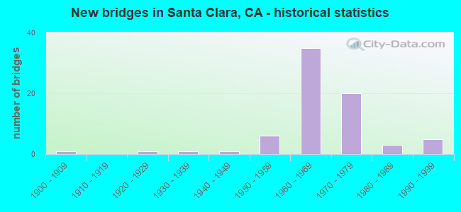
- New bridges - historical statistics
- 11900-1909
- 11920-1929
- 11930-1939
- 11940-1949
- 61950-1959
- 351960-1969
- 201970-1979
- 31980-1989
- 51990-1999

- Reconstructed bridges - Historical Statistics
- 11940-1949
- 01950-1959
- 11960-1969
- 41970-1979
- 31980-1989
- 31990-1999
- 02000-2009
- 12010-2019


- Bridge Condition - Deck
- 54.8%Good
- 11.9%Satisfactory
- 21.4%Fair
- 11.9%Poor

- Bridge Condition - Superstructure
- 69.0%Good
- 7.1%Satisfactory
- 16.7%Fair
- 7.1%Poor

- Bridge Condition - Substructure
- 92.9%Good
- 4.8%Satisfactory
- 2.4%Fair

- Bridge Condition - Channel
- 14.3%Excellent
- 57.1%Very good
- 8.6%Good
- 14.3%Satisfactory
- 5.7%Fair

- Bridge Condition - Culverts
- 37.5%Good
- 62.5%Satisfactory
Find on map >> Show street view
Structure Number: 37C0308, Location: INTERSECTION (Lat: 37.362008, Lng: -121.986361), Route carried "on" structure: City street , Year Built: 1961, Status: Open, Structure Length: 1.22m (4.00ft), Average Daily Traffic: 500 (year 2011), Truck Traffic: 1%, Average Future Daily Traffic: 571 (year 2043), Design Load: HS 15, Features Intersected: CALABAZAS CREEK, Facility Carried by Structure: MACHADO & CALABAZA
Minimum Vertical Clearance: 30+ m (98+ ft), Kilometerpoint: 0.000, Lanes on structure: 2, Owner: City or Municipal Highway Agency, Approaching Roadway Width: 12.8m (42.0ft), Material/Design: Concrete, Design/Construction: Slab, Number Of Spans In Main Unit: 1, Length of Maximum Span: 11.3m (37.1ft), Curb or Sidewalk Widths: Left: 1.3m (4.3ft), Right: 1.3m (4.3ft), Curb-To-Curb Width: 12.1m (39.7ft), Out-to-Out Width: 15.3m (50.2ft)
Condition: Deck: Poor, Superstructure: Poor, Substructure: Good, Channel: Very good, Operating Rating: 50.5 metric tons, Method Used To Determine Operating Rating: Load Factor (LF), Inventory Rating: 30.5 metric tons, Method Used To Determine Inventory Rating: Load Factor (LF), Structural Evaluation: Meets minimum limits, Deck Geometry: Better than present minimum criteria, Waterway Adequacy: Better than present minimum criteria, Approach Roadway Alignment: Better than present minimum criteria, Length Of Structure Improvement: 1.22m (4.00ft), Designated Inspection Frequency: Every 24 months, Inspection Date: June 2021, Bridge Improvement Cost: $186,000, Roadway Improvement Cost: $37,000, Total Project Cost: $312,000 ( Estimate for 2018), Deck Structure Type: Concrete Cast-file-Place
Find on map >> Show street view
Structure Number: 37C0309, Location: INTERSECTION CALABAZAS (Lat: 37.354242, Lng: -121.984044), Route carried "on" structure: City street , Year Built: 1958, Status: Open, Structure Length: 1.16m (3.81ft), Average Daily Traffic: 1,300 (year 2011), Truck Traffic: 2%, Average Future Daily Traffic: 3,704 (year 2043), Features Intersected: CALABAZAS CREEK, Facility Carried by Structure: WARBURTON AVENUE
Minimum Vertical Clearance: 30+ m (98+ ft), Kilometerpoint: 0.000, Lanes on structure: 2, Owner: City or Municipal Highway Agency, Approaching Roadway Width: 12.2m (40.0ft), Material/Design: Prestressed concrete, Design/Construction: Slab, Number Of Spans In Main Unit: 1, Length of Maximum Span: 11.0m (36.1ft), Curb or Sidewalk Widths: Left: 1.1m (3.6ft), Right: 1.1m (3.6ft), Curb-To-Curb Width: 12.2m (40.0ft), Out-to-Out Width: 14.6m (47.9ft)
Condition: Deck: Good, Superstructure: Good, Substructure: Good, Channel: Very good, Operating Rating: 34.7 metric tons, Method Used To Determine Operating Rating: Field evaluation and documented engineering judgment, Inventory Rating: 20.7 metric tons, Method Used To Determine Inventory Rating: Field evaluation and documented engineering judgment, Structural Evaluation: Somewhat better than minimum adequacy, Deck Geometry: Better than present minimum criteria, Waterway Adequacy: Equal to present desirable criteria, Approach Roadway Alignment: Equal to present desirable criteria, Designated Inspection Frequency: Every 24 months, Inspection Date: June 2021, Deck Structure Type: Concrete Cast-file-Place, Wearing Surface/Protective System: Wearing Surface: Bituminous
Find on map >> Show street view
Structure Number: 37C0311, Location: 0.15 MI E/O POMEROY (Lat: 37.334069, Lng: -121.985361), Route carried "on" structure: City street , Year Built: 1960, Status: Open, Structure Length: 1.65m (5.41ft), Average Daily Traffic: 1,727 (year 2011), Truck Traffic: 1%, Average Future Daily Traffic: 2,237 (year 2043), Design Load: HS 15, Features Intersected: SARATOGA CREEK, Facility Carried by Structure: FORBES AVE
Minimum Vertical Clearance: 30+ m (98+ ft), Kilometerpoint: 0.000, Lanes on structure: 2, Owner: City or Municipal Highway Agency, Approaching Roadway Width: 12.2m (40.0ft), Skew: 1 degrees, Material/Design: Concrete, Design/Construction: Slab, Number Of Spans In Main Unit: 1, Length of Maximum Span: 14.9m (48.9ft), Curb or Sidewalk Widths: Left: 1.2m (3.9ft), Right: 1.2m (3.9ft), Curb-To-Curb Width: 12.2m (40.0ft), Out-to-Out Width: 15.2m (49.9ft)
Condition: Deck: Satisfactory, Superstructure: Satisfactory, Substructure: Good, Channel: Very good, Operating Rating: 55.1 metric tons, Method Used To Determine Operating Rating: Load Factor (LF), Inventory Rating: 33.0 metric tons, Method Used To Determine Inventory Rating: Load Factor (LF), Structural Evaluation: Equal to present minimum criteria, Deck Geometry: Better than present minimum criteria, Waterway Adequacy: Better than present minimum criteria, Approach Roadway Alignment: Equal to present desirable criteria, Designated Inspection Frequency: Every 48 months, Inspection Date: June 2021, Deck Structure Type: Concrete Cast-file-Place, Wearing Surface/Protective System: Wearing Surface: Bituminous
Find on map >> Show street view
Structure Number: 37C0322, Location: 0.2 MI S MONROE ST (Lat: 37.363922, Lng: -121.987278), Route carried "on" structure: City street , Year Built: 1961, Status: Open, Structure Length: 0.83m (2.72ft), Average Daily Traffic: 2,500 (year 2010), Truck Traffic: 4%, Average Future Daily Traffic: 2,856 (year 2043), Features Intersected: CALABAZAS CREEK, Facility Carried by Structure: CALABAZAS BLVD
Minimum Vertical Clearance: 30+ m (98+ ft), Kilometerpoint: 0.000, Lanes on structure: 4, Owner: City or Municipal Highway Agency, Approaching Roadway Width: 17.4m (57.1ft), Skew: 27 degrees, Material/Design: Concrete continuous, Design/Construction: Culvert, Number Of Spans In Main Unit: 2, Length of Maximum Span: 3.7m (12.1ft), Curb or Sidewalk Widths: Left: 1.5m (4.9ft), Right: 1.5m (4.9ft)
Condition: Channel: Excellent, Culverts: Satisfactory, Operating Rating: 40.5 metric tons, Method Used To Determine Operating Rating: Field evaluation and documented engineering judgment, Inventory Rating: 24.3 metric tons, Method Used To Determine Inventory Rating: Field evaluation and documented engineering judgment, Structural Evaluation: Equal to present minimum criteria, Waterway Adequacy: Better than present minimum criteria, Approach Roadway Alignment: Better than present minimum criteria, Designated Inspection Frequency: Every 24 months, Inspection Date: June 2021
Find on map >> Show street view
Structure Number: 37C0324, Location: 0.5 MI E LAWRENCE EXPWY (Lat: 37.377536, Lng: -121.986906), Route carried "on" structure: City street , Year Built: 1968, Status: Open, Structure Length: 0.94m (3.08ft), Average Daily Traffic: 1,750 (year 2013), Truck Traffic: 5%, Average Future Daily Traffic: 64,976 (year 2038), Features Intersected: CALABAZAS CREEK, Facility Carried by Structure: CENTRAL EXPRESSWAY
Minimum Vertical Clearance: 30+ m (98+ ft), Kilometerpoint: 0.000, Lanes on structure: 6, Base Highway Network: Yes, Owner: County Highway Agency, Approaching Roadway Width: 30.5m (100.1ft), Skew: 20 degrees, Material/Design: Concrete continuous, Design/Construction: Culvert, Number Of Spans In Main Unit: 3, Length of Maximum Span: 2.7m (8.9ft), Curb-To-Curb Width: 30.4m (99.7ft), Out-to-Out Width: 42.2m (138.5ft)
Condition: Channel: Very good, Culverts: Satisfactory, Operating Rating: 40.5 metric tons, Method Used To Determine Operating Rating: Field evaluation and documented engineering judgment, Inventory Rating: 24.3 metric tons, Method Used To Determine Inventory Rating: Field evaluation and documented engineering judgment, Structural Evaluation: Equal to present minimum criteria, Deck Geometry: Superior to present desirable criteria, Waterway Adequacy: Better than present minimum criteria, Approach Roadway Alignment: Equal to present desirable criteria, Designated Inspection Frequency: Every 24 months, Inspection Date: October 2020
Find on map >> Show street view
Structure Number: 37C0326, Location: AT CALABAZAS BLVD (Lat: 37.350139, Lng: -121.986669), Route carried "on" structure: City street , Year Built: 1940, Year Reconstructed: 1982, Status: Open, Structure Length: 0.88m (2.89ft), Average Daily Traffic: 5,000 (year 2010), Truck Traffic: 3%, Average Future Daily Traffic: 7,407 (year 2043), Features Intersected: CALABAZAS CREEK, Facility Carried by Structure: POMEROY AVE
Minimum Vertical Clearance: 30+ m (98+ ft), Kilometerpoint: 0.000, Lanes on structure: 2, Owner: City or Municipal Highway Agency, Approaching Roadway Width: 12.2m (40.0ft), Skew: 1 degrees, Material/Design: Concrete, Design/Construction: Culvert, Number Of Spans In Main Unit: 2, Length of Maximum Span: 4.0m (13.1ft), Curb or Sidewalk Widths: Left: 1.5m (4.9ft), Right: 2.4m (7.9ft), Curb-To-Curb Width: 13.4m (44.0ft), Out-to-Out Width: 18.0m (59.1ft)
Condition: Channel: Excellent, Culverts: Satisfactory, Operating Rating: 27.2 metric tons, Method Used To Determine Operating Rating: Field evaluation and documented engineering judgment, Inventory Rating: 16.2 metric tons, Method Used To Determine Inventory Rating: Field evaluation and documented engineering judgment, Structural Evaluation: Meets minimum limits, Deck Geometry: Better than present minimum criteria, Waterway Adequacy: Better than present minimum criteria, Approach Roadway Alignment: Equal to present desirable criteria, Designated Inspection Frequency: Every 24 months, Inspection Date: June 2021
Find on map >> Show street view
Structure Number: 37C035, Location: 0.6 MI N LEAVESLY RD (Lat: 37.027978, Lng: -121.578719), Route carried "on" structure: City street , Year Built: 1989, Status: Open, Structure Length: 1.55m (5.09ft), Average Daily Traffic: 11,300 (year 2012), Truck Traffic: 6%, Average Future Daily Traffic: 11,954 (year 2042), Features Intersected: WEST BRANCH LLAGAS CREEK, Facility Carried by Structure: MONTEREY ROAD
Minimum Vertical Clearance: 30+ m (98+ ft), Kilometerpoint: 0.000, Lanes on structure: 4, Base Highway Network: Yes, Owner: City or Municipal Highway Agency, Approaching Roadway Width: 22.3m (73.2ft), Material/Design: Concrete continuous, Design/Construction: Culvert, Number Of Spans In Main Unit: 4, Length of Maximum Span: 3.7m (12.1ft), Curb or Sidewalk Widths: Left: 1.5m (4.9ft), Right: 0.0m, Curb-To-Curb Width: 22.3m (73.2ft), Out-to-Out Width: 77.7m (254.9ft)
Condition: Channel: Very good, Culverts: Good, Operating Rating: 54.1 metric tons, Method Used To Determine Operating Rating: Field evaluation and documented engineering judgment, Inventory Rating: 32.4 metric tons, Method Used To Determine Inventory Rating: Field evaluation and documented engineering judgment, Structural Evaluation: Better than present minimum criteria, Deck Geometry: Superior to present desirable criteria, Waterway Adequacy: Better than present minimum criteria, Approach Roadway Alignment: Equal to present desirable criteria, Designated Inspection Frequency: Every 48 months, Inspection Date: December 2020, Deck Structure Type: Concrete Cast-file-Place, Wearing Surface/Protective System: Wearing Surface: Bituminous
Find on map >> Show street view
Structure Number: 37C0428, Location: 1500' EAST OF LAWRENCE EX (Lat: 37.332131, Lng: -122.001558), Route carried "on" structure: City street , Year Built: 1958, Year Reconstructed: 2001, Status: Open, Structure Length: 1.27m (4.17ft), Average Daily Traffic: 5,000 (year 2012), Truck Traffic: 2%, Average Future Daily Traffic: 8,189 (year 2041), Features Intersected: CALABAZAS CREEK, Facility Carried by Structure: PRUNERIDGE AVE
Minimum Vertical Clearance: 30+ m (98+ ft), Kilometerpoint: 0.000, Lanes on structure: 3, Owner: City or Municipal Highway Agency, Approaching Roadway Width: 19.5m (64.0ft), Material/Design: Concrete, Design/Construction: Slab, Number Of Spans In Main Unit: 3, Number Of Approach Spans: 2, Length of Maximum Span: 4.9m (16.1ft), Curb or Sidewalk Widths: Left: 1.5m (4.9ft), Right: 1.5m (4.9ft), Curb-To-Curb Width: 18.5m (60.7ft), Out-to-Out Width: 23.4m (76.8ft)
Condition: Deck: Fair, Superstructure: Fair, Substructure: Good, Channel: Very good, Operating Rating: 26.2 metric tons, Method Used To Determine Operating Rating: Field evaluation and documented engineering judgment, Inventory Rating: 15.6 metric tons, Method Used To Determine Inventory Rating: Field evaluation and documented engineering judgment, Structural Evaluation: Meets minimum limits, Deck Geometry: Superior to present desirable criteria, Waterway Adequacy: Equal to present desirable criteria, Approach Roadway Alignment: Equal to present desirable criteria, Designated Inspection Frequency: Every 24 months, Inspection Date: June 2021, Wearing Surface/Protective System: Wearing Surface: Bituminous
Find on map >> Show street view
Structure Number: 37C05, Location: N MISSION COLLEGE BLVD (Lat: 37.390506, Lng: -121.968600), Route carried "on" structure: City street , Year Built: 1966, Status: Open, Structure Length: 3.44m (11.29ft), Average Daily Traffic: 5,269 (year 2010), Truck Traffic: 3%, Average Future Daily Traffic: 5,609 (year 2043), Features Intersected: SAN TOMAS AQUINO CREEK, Facility Carried by Structure: AGNEW RD
Minimum Vertical Clearance: 30+ m (98+ ft), Kilometerpoint: 0.000, Lanes on structure: 2, Owner: City or Municipal Highway Agency, Approaching Roadway Width: 13.4m (44.0ft), Skew: 3 degrees, Material/Design: Concrete continuous, Design/Construction: Tee Beam, Number Of Spans In Main Unit: 3, Length of Maximum Span: 13.3m (43.6ft), Curb or Sidewalk Widths: Left: 1.5m (4.9ft), Right: 1.5m (4.9ft), Curb-To-Curb Width: 13.4m (44.0ft), Out-to-Out Width: 17.1m (56.1ft)
Condition: Deck: Poor, Superstructure: Good, Substructure: Good, Channel: Fair, Operating Rating: 42.8 metric tons, Method Used To Determine Operating Rating: Load and Resistance Factor Rating (LRFR) rating reported by rating factor(RF) method using HL-93 loadings, Inventory Rating: 33.0 metric tons, Method Used To Determine Inventory Rating: Load and Resistance Factor Rating (LRFR) rating reported by rating factor(RF) method using HL-93 loadings, Structural Evaluation: Better than present minimum criteria, Deck Geometry: Equal to present minimum criteria, Waterway Adequacy: Somewhat better than minimum adequacy, Approach Roadway Alignment: Equal to present desirable criteria, Designated Inspection Frequency: Every 24 months, Inspection Date: June 2021, Deck Structure Type: Concrete Cast-file-Place
Find on map >> Show street view
Structure Number: 37C055, Location: 0.6 MI N SAN MARTIN AVE (Lat: 37.094358, Lng: -121.611539), Route carried "on" structure: County highway , Year Built: 1925, Status: Open, Structure Length: 3.24m (10.63ft), Average Daily Traffic: 1,780 (year 2014), Truck Traffic: 5%, Average Future Daily Traffic: 2,000 (year 2037), Features Intersected: LLAGAS CREEK, Facility Carried by Structure: LLAGAS AVE
Minimum Vertical Clearance: 30+ m (98+ ft), Kilometerpoint: 0.000, Lanes on structure: 2, Owner: County Highway Agency, Approaching Roadway Width: 7.3m (24.0ft), Skew: 2 degrees, Material/Design: Concrete continuous, Design/Construction: Girder and Floorbeam System, Number Of Spans In Main Unit: 2, Length of Maximum Span: 15.9m (52.2ft), Curb-To-Curb Width: 6.1m (20.0ft), Out-to-Out Width: 7.4m (24.3ft)
Condition: Deck: Good, Superstructure: Good, Substructure: Good, Channel: Satisfactory, Operating Rating: 24.3 metric tons, Method Used To Determine Operating Rating: Field evaluation and documented engineering judgment, Inventory Rating: 14.6 metric tons, Method Used To Determine Inventory Rating: Field evaluation and documented engineering judgment, Structural Evaluation: Meets minimum limits, Deck Geometry: High priority of replacement, Waterway Adequacy: Better than present minimum criteria, Approach Roadway Alignment: Equal to present desirable criteria, Designated Inspection Frequency: Every 24 months, Inspection Date: November 2020, Deck Structure Type: Concrete Cast-file-Place, Wearing Surface/Protective System: Wearing Surface: Bituminous
Find on map >> Show street view
Structure Number: 37C0557, Location: JUST SOUTH OF SH 237 (Lat: 37.410403, Lng: -121.979267), Route carried "on" structure: City street , Year Built: 1973, Status: Open, Structure Length: 4.21m (13.81ft), Average Daily Traffic: 5,291 (year 2010), Truck Traffic: 1%, Average Future Daily Traffic: 5,926 (year 2043), Features Intersected: SAN TOMAS AQUINO CREEK, Facility Carried by Structure: MTN VIEW-ALVISO RD
Minimum Vertical Clearance: 30+ m (98+ ft), Kilometerpoint: 0.000, Lanes on structure: 2, Owner: City or Municipal Highway Agency, Approaching Roadway Width: 14.6m (47.9ft), Skew: 1 degrees, Material/Design: Concrete continuous, Design/Construction: Slab, Number Of Spans In Main Unit: 4, Length of Maximum Span: 10.4m (34.1ft), Curb or Sidewalk Widths: Left: 0.9m (3.0ft), Right: 0.9m (3.0ft), Curb-To-Curb Width: 14.6m (47.9ft), Out-to-Out Width: 17.1m (56.1ft)
Condition: Deck: Poor, Superstructure: Poor, Substructure: Good, Channel: Very good, Operating Rating: 83.9 metric tons, Method Used To Determine Operating Rating: Load Factor (LF), Inventory Rating: 50.5 metric tons, Method Used To Determine Inventory Rating: Load Factor (LF), Structural Evaluation: Meets minimum limits, Deck Geometry: Superior to present desirable criteria, Waterway Adequacy: Better than present minimum criteria, Approach Roadway Alignment: Equal to present minimum criteria, Length Of Structure Improvement: 4.21m (13.81ft), Designated Inspection Frequency: Every 24 months, Inspection Date: June 2021, Bridge Improvement Cost: $752,000, Roadway Improvement Cost: $150,000, Total Project Cost: $1,263,000 ( Estimate for 2017), Deck Structure Type: Concrete Cast-file-Place
Find on map >> Show street view
Structure Number: 37 0036, Location: 04-SCL-101-41.04-SCL (Lat: 37.377656, Lng: -121.947458), Route carried "under" structure: US 101, Year Built: 1961, Structure Length: 0. m, Average Daily Traffic: 134,000 (year 2009), Truck Traffic: 4%, Features Intersected: U.S. HIGHWAY 101, Facility Carried by Structure: UP RR & AMTRAK
Minimum Vertical Clearance: 4.67m (15.32ft), Kilometerpoint: 41.040, Lanes under structure: 8, Material/Design: Steel, Design/Construction: Girder and Floorbeam System, Length of Maximum Span: 29.3m (96.1ft)
Find on map >> Show street view
Structure Number: 37 0166, Location: 04-SCL-101-41.98-SCL (Lat: 37.381600, Lng: -121.963925), Route carried "under" structure: Ramp US 101, Year Built: 1961, Structure Length: 0. m, Average Daily Traffic: 15,700 (year 2004), Truck Traffic: 5%, Features Intersected: U.S. HIGHWAY 101, Facility Carried by Structure: SAN TOMAS EXPWY
Minimum Vertical Clearance: 4.62m (15.16ft), Kilometerpoint: 41.980, Lanes on structure: 8, Lanes under structure: 2, Material/Design: Prestressed concrete, Design/Construction: Stringer/Multi-beam, Length of Maximum Span: 25.0m (82.0ft)
Find on map >> Show street view
Structure Number: 37 0166, Location: 04-SCL-101-41.98-SCL (Lat: 37.381600, Lng: -121.963925), Route carried "under" structure: US 101, Year Built: 1961, Structure Length: 0. m, Average Daily Traffic: 134,000 (year 2009), Truck Traffic: 4%, Features Intersected: U.S. HIGHWAY 101, Facility Carried by Structure: SAN TOMAS EXPWY
Minimum Vertical Clearance: 4.57m (14.99ft), Kilometerpoint: 41.980, Lanes on structure: 8, Lanes under structure: 8, Material/Design: Prestressed concrete, Design/Construction: Stringer/Multi-beam, Length of Maximum Span: 25.0m (82.0ft)
Find on map >> Show street view
Structure Number: 37 0166, Location: 04-SCL-101-41.98-SCL (Lat: 37.381600, Lng: -121.963925), Route carried "under" structure: Ramp US 101, Year Built: 1961, Structure Length: 0. m, Average Daily Traffic: 13,100 (year 2004), Truck Traffic: 5%, Features Intersected: U.S. HIGHWAY 101, Facility Carried by Structure: SAN TOMAS EXPWY
Minimum Vertical Clearance: 4.64m (15.22ft), Kilometerpoint: 41.980, Lanes on structure: 8, Lanes under structure: 2, Material/Design: Prestressed concrete, Design/Construction: Stringer/Multi-beam, Length of Maximum Span: 25.0m (82.0ft)
Find on map >> Show street view
Structure Number: 37 017, Location: 04-SCL-101-41.07-SCL (Lat: 37.377703, Lng: -121.948222), Route carried "under" structure: US 101, Year Built: 1961, Structure Length: 0. m, Average Daily Traffic: 134,000 (year 2009), Truck Traffic: 4%, Features Intersected: U.S. HIGHWAY 101, Facility Carried by Structure: LAFAYETTE ST (NB)
Minimum Vertical Clearance: 4.67m (15.32ft), Kilometerpoint: 41.070, Lanes on structure: 2, Lanes under structure: 8, Material/Design: Prestressed concrete, Design/Construction: Stringer/Multi-beam, Length of Maximum Span: 22.9m (75.1ft)
Find on map >> Show street view
Structure Number: 37 0211, Location: 04-SCL-280-7.39-SCL (Lat: 37.322783, Lng: -121.998847), Route carried "under" structure: City street , Year Built: 1965, Structure Length: 0. m, Average Daily Traffic: 31,550 (year 2001), Truck Traffic: 5%, Features Intersected: STEVENS CREEK BOULEVARD, Facility Carried by Structure: INTERSTATE 280
Minimum Vertical Clearance: 4.62m (15.16ft), Kilometerpoint: 0.000, Lanes on structure: 8, Lanes under structure: 6, Material/Design: Prestressed concrete, Design/Construction: Stringer/Multi-beam, Length of Maximum Span: 34.1m (111.9ft)
Find on map >> Show street view
Structure Number: 37 0214, Location: 04-SCL-082-11.38-SCL (Lat: 37.355194, Lng: -121.943008), Route carried "under" structure: State highway 82, Year Built: 1961, Structure Length: 0. m, Average Daily Traffic: 23,900 (year 2009), Features Intersected: STATE ROUTE 82, Facility Carried by Structure: DE LA CRUZ BLVD
Minimum Vertical Clearance: 4.62m (15.16ft), Kilometerpoint: 11.380, Lanes on structure: 4, Lanes under structure: 6, Material/Design: Prestressed concrete, Design/Construction: Stringer/Multi-beam, Length of Maximum Span: 24.7m (81.0ft)
Find on map >> Show street view
Structure Number: 37 0337, Location: 04-SCL-082-14.34-SCL (Lat: 37.352075, Lng: -121.996267), Route carried "under" structure: State highway 82, Year Built: 1970, Structure Length: 0. m, Average Daily Traffic: 40,750 (year 2009), Features Intersected: STATE ROUTE 82, Facility Carried by Structure: LAWRENCE EXPWY
Minimum Vertical Clearance: 4.95m (16.24ft), Kilometerpoint: 14.340, Lanes on structure: 8, Lanes under structure: 10, Material/Design: Prestressed concrete continuous, Design/Construction: Stringer/Multi-beam, Length of Maximum Span: 28.3m (92.8ft)
Find on map >> Show street view
Structure Number: 37 039, Location: 04-SCL-101-42.73-SCL (Lat: 37.385333, Lng: -121.976806), Route carried "under" structure: US 101, Year Built: 1975, Structure Length: 0. m, Average Daily Traffic: 134,000 (year 2009), Truck Traffic: 4%, Features Intersected: U.S. HIGHWAY 101, Facility Carried by Structure: BOWERS AVENUE
Minimum Vertical Clearance: 5.36m (17.59ft), Kilometerpoint: 42.730, Lanes on structure: 6, Lanes under structure: 10, Material/Design: Prestressed concrete continuous, Design/Construction: Box Beam or Girders - Multiple, Length of Maximum Span: 39.3m (128.9ft)
Find on map >> Show street view
Structure Number: 37 0391, Location: 04-SCL-101-41.08-SCL (Lat: 37.377736, Lng: -121.948386), Route carried "under" structure: US 101, Year Built: 1975, Structure Length: 0. m, Average Daily Traffic: 134,000 (year 2009), Truck Traffic: 4%, Features Intersected: U.S. HIGHWAY 101, Facility Carried by Structure: LAFAYETTE ST (SB)
Minimum Vertical Clearance: 5.28m (17.32ft), Kilometerpoint: 41.080, Lanes on structure: 2, Lanes under structure: 8, Material/Design: Prestressed concrete continuous, Design/Construction: Box Beam or Girders - Multiple, Length of Maximum Span: 34.0m (111.5ft)
Find on map >> Show street view
Structure Number: 37 0471L, Location: 04-SCL-237-R5.83-SCL (Lat: 37.415675, Lng: -121.977828), Route carried "under" structure: City street , Year Built: 1994, Structure Length: 0. m, Average Daily Traffic: 35,000 (year 1995), Truck Traffic: 3%, Features Intersected: GREAT AMERICA PARKWAY, Facility Carried by Structure: STATE ROUTE 237 WB
Minimum Vertical Clearance: 5.25m (17.22ft), Kilometerpoint: 0.000, Lanes on structure: 3, Lanes under structure: 6, Material/Design: Prestressed concrete continuous, Design/Construction: Box Beam or Girders - Multiple, Length of Maximum Span: 29.6m (97.1ft)
Find on map >> Show street view
Structure Number: 37 0471R, Location: 04-SCL-237-R5.83-SCL (Lat: 37.415394, Lng: -121.977833), Route carried "under" structure: City street , Year Built: 1994, Structure Length: 0. m, Average Daily Traffic: 35,000 (year 1995), Truck Traffic: 3%, Features Intersected: GREAT AMERICA PARKWAY, Facility Carried by Structure: EB STATE ROUTE 237
Minimum Vertical Clearance: 5.16m (16.93ft), Kilometerpoint: 0.000, Lanes on structure: 3, Lanes under structure: 7, Material/Design: Prestressed concrete continuous, Design/Construction: Box Beam or Girders - Multiple, Length of Maximum Span: 29.6m (97.1ft)
Find on map >> Show street view
Structure Number: 37C0066, Location: AT UP TRACKS (Lat: 37.370294, Lng: -121.977100), Route carried "under" structure: City street , Year Built: 1974, Structure Length: 0. m, Average Daily Traffic: 28,000 (year 2010), Truck Traffic: 1%, Features Intersected: BOWERS AVE, Facility Carried by Structure: CALTRAIN,UP,AMTRAK
Minimum Vertical Clearance: 4.60m (15.09ft), Kilometerpoint: 0.000, Lanes under structure: 4, Material/Design: Prestressed concrete, Design/Construction: Box Beam or Girders - Multiple, Length of Maximum Span: 16.0m (52.5ft)
Find on map >> Show street view
Structure Number: 37C0067, Location: AT BOWERS AVE (Lat: 37.369883, Lng: -121.977017), Route carried "under" structure: City street , Year Built: 1970, Structure Length: 0. m, Average Daily Traffic: 28,000 (year 2010), Truck Traffic: 1%, Features Intersected: BOWERS AVE, Facility Carried by Structure: PEDESTRIAN WALKWAY
Minimum Vertical Clearance: 5.53m (18.14ft), Kilometerpoint: 0.000, Lanes under structure: 4, Material/Design: Concrete continuous, Design/Construction: Box Beam or Girders - Single/Spread, Length of Maximum Span: 21.6m (70.9ft)
Find on map >> Show street view
Structure Number: 37C0078, Location: AT UP TRACKS (Lat: 37.380883, Lng: -121.949439), Route carried "under" structure: City street , Year Built: 1970, Structure Length: 0. m, Average Daily Traffic: 25,000 (year 2011), Truck Traffic: 4%, Features Intersected: LAFAYETTE STREET, Facility Carried by Structure: CALTRAIN,UP,AMTRAK
Minimum Vertical Clearance: 5.08m (16.67ft), Kilometerpoint: 0.000, Lanes under structure: 4, Material/Design: Prestressed concrete, Design/Construction: Stringer/Multi-beam, Length of Maximum Span: 26.2m (86.0ft)
Find on map >> Show street view
Structure Number: 37C0081, Location: AT SAN TOMAS EXPWY (Lat: 37.374258, Lng: -121.966169), Route carried "under" structure: City street , Year Built: 1977, Structure Length: 0. m, Average Daily Traffic: 45,266 (year 1998), Truck Traffic: 2%, Features Intersected: SAN TOMAS EXPRESSWAY, Facility Carried by Structure: CENTRAL EXPRESSWAY
Minimum Vertical Clearance: 4.82m (15.81ft), Kilometerpoint: 0.000, Lanes on structure: 6, Lanes under structure: 8, Material/Design: Prestressed concrete, Design/Construction: Box Beam or Girders - Multiple, Length of Maximum Span: 28.7m (94.2ft)
Find on map >> Show street view
Structure Number: 37C0129, Location: AT SP RR (Lat: 37.358214, Lng: -121.947467), Route carried "under" structure: City street , Year Built: 1936, Structure Length: 0. m, Average Daily Traffic: 25,000 (year 2011), Truck Traffic: 4%, Features Intersected: LAFAYETTE STREET, Facility Carried by Structure: CALTRAIN,UP,AMTRAK
Minimum Vertical Clearance: 4.72m (15.49ft), Kilometerpoint: 0.000, Lanes under structure: 4, Material/Design: Steel, Design/Construction: Girder and Floorbeam System, Length of Maximum Span: 23.0m (75.5ft)
Find on map >> Show street view
Structure Number: 37C0145, Location: NEAR DE LA CRUZ (Lat: 37.358153, Lng: -121.940367), Route carried "under" structure: Ramp City street , Year Built: 1969, Structure Length: 0. m, Average Daily Traffic: 10,000 (year 2010), Truck Traffic: 10%, Features Intersected: DE LA CRUZ BLVD NB, Facility Carried by Structure: COLEMAN OFF RAMP
Minimum Vertical Clearance: 4.32m (14.17ft), Kilometerpoint: 0.000, Lanes on structure: 1, Lanes under structure: 1, Material/Design: Concrete, Design/Construction: Box Beam or Girders - Multiple, Length of Maximum Span: 19.5m (64.0ft)
Find on map >> Show street view
Structure Number: 37C0147, Location: COLEMAN ST (Lat: 37.358203, Lng: -121.940014), Route carried "under" structure: City street , Year Built: 1969, Structure Length: 0. m, Average Daily Traffic: 8,498 (year 2010), Truck Traffic: 10%, Features Intersected: DE LA CRUZ BL-COLMAN AV, Facility Carried by Structure: DE LA CRUZ BLVD NB
Minimum Vertical Clearance: 4.57m (14.99ft), Kilometerpoint: 0.000, Lanes on structure: 1, Lanes under structure: 2, Material/Design: Concrete continuous, Design/Construction: Box Beam or Girders - Multiple, Length of Maximum Span: 15.8m (51.8ft)
Find on map >> Show street view
Structure Number: 37C0201, Location: 1.2 MILES W/O N. FIRST (Lat: 37.389000, Lng: -121.955533), Route carried "under" structure: City street , Year Built: 1962, Structure Length: 0. m, Average Daily Traffic: 10,000 (year 2001), Truck Traffic: 1%, Features Intersected: UP RR, LAFAYETTE,BASSETT, Facility Carried by Structure: MONTAGUE EXPWY
Minimum Vertical Clearance: 7.54m (24.74ft), Kilometerpoint: 0.000, Lanes on structure: 8, Lanes under structure: 5, Material/Design: Steel, Design/Construction: Stringer/Multi-beam, Length of Maximum Span: 26.5m (86.9ft)
Find on map >> Show street view
Structure Number: 37C0213, Location: TASMAN DR @ LAFAYETTE (Lat: 37.406042, Lng: -121.967161), Route carried "under" structure: City street , Year Built: 1976, Structure Length: 0. m, Average Daily Traffic: 18,370 (year 2008), Truck Traffic: 4%, Features Intersected: UP RR, AMTRAK, LAFAYETTE, Facility Carried by Structure: TASMAN DR & LRT
Minimum Vertical Clearance: 7.19m (23.59ft), Kilometerpoint: 0.000, Lanes on structure: 4, Lanes under structure: 4, Material/Design: Concrete continuous, Design/Construction: Box Beam or Girders - Multiple, Length of Maximum Span: 31.4m (103.0ft)
Find on map >> Show street view
Structure Number: 37C0356, Location: 0.6 MI S/O S.H. 237 (Lat: 37.410036, Lng: -121.969594), Route carried "under" structure: City street , Year Built: 1985, Structure Length: 0. m, Average Daily Traffic: 20,000 (year 2011), Truck Traffic: 5%, Features Intersected: UP RR, AMTRAK, LAFAYETTE, Facility Carried by Structure: GOLF CART PATH
Minimum Vertical Clearance: 5.73m (18.80ft), Kilometerpoint: 0.000, Lanes under structure: 4, Material/Design: Prestressed concrete continuous, Design/Construction: Box Beam or Girders - Multiple, Length of Maximum Span: 29.3m (96.1ft)
Find on map >> Show street view
Structure Number: 37C0429, Location: 800 FT S MISSION COLLEGE (Lat: 37.386483, Lng: -121.966347), Route carried "under" structure: City street , Year Built: 1995, Structure Length: 0. m, Average Daily Traffic: 5,000 (year 2012), Truck Traffic: 5%, Features Intersected: JULIETTE LANE, Facility Carried by Structure: PEDESTRIAN WALKWAY
Minimum Vertical Clearance: 4.80m (15.75ft), Kilometerpoint: 0.000, Lanes under structure: 3, Material/Design: Steel, Design/Construction: Truss - Thru, Length of Maximum Span: 25.0m (82.0ft)