Bridge Statistics for Sallisaw, Oklahoma (OK)
Condition, Traffic, Stress, Structural Evaluation, Project Costs
- National Bridge Inventory (NBI) Statistics
- 255Number of bridges
- 1,942ft / 592mTotal length
- $149,588,000Total costs
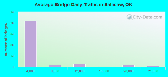
- 755,758Total average daily traffic
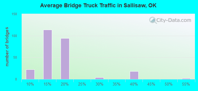
- 175,777Total average daily truck traffic
- National Bridge Inventory (NBI) Registered Bridges for Sallisaw
- No street view available for this location
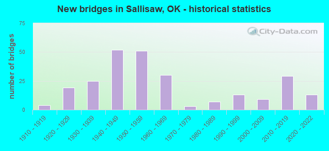
- New bridges - historical statistics
- 41910-1919
- 191920-1929
- 251930-1939
- 521940-1949
- 511950-1959
- 301960-1969
- 31970-1979
- 71980-1989
- 131990-1999
- 92000-2009
- 292010-2019
- 132020-2022
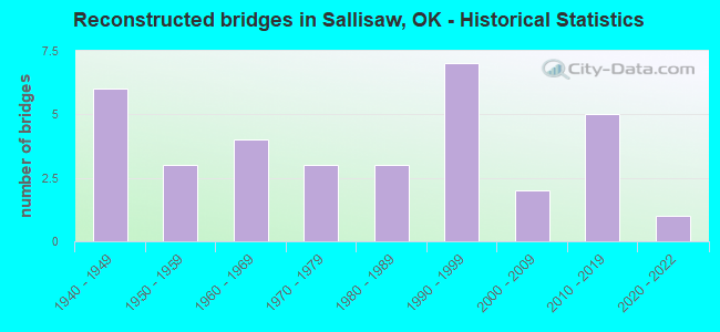
- Reconstructed bridges - Historical Statistics
- 61940-1949
- 31950-1959
- 41960-1969
- 31970-1979
- 31980-1989
- 71990-1999
- 22000-2009
- 52010-2019
- 12020-2022
- Bridge Condition - Deck
- 1.3%Excellent
- 14.5%Very good
- 28.9%Good
- 19.7%Satisfactory
- 21.1%Fair
- 5.3%Poor
- 7.9%Serious
- 1.3%Critical
- 7.9%Failed
- Bridge Condition - Superstructure
- 3.3%Excellent
- 16.4%Very good
- 21.7%Good
- 24.3%Satisfactory
- 19.7%Fair
- 5.3%Poor
- 1.3%Serious
- 7.9%Failed
- Bridge Condition - Substructure
- 19.7%Very good
- 21.7%Good
- 18.4%Satisfactory
- 15.1%Fair
- 13.2%Poor
- 3.3%Serious
- 0.7%Critical
- 7.9%Failed
- Bridge Condition - Channel
- 2.7%Excellent
- 12.9%Very good
- 27.7%Good
- 31.7%Satisfactory
- 18.3%Fair
- 5.4%Poor
- 1.3%Serious
- 0.4%Failed
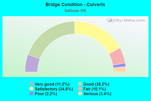
- Bridge Condition - Culverts
- 11.2%Very good
- 38.2%Good
- 34.8%Satisfactory
- 10.1%Fair
- 2.2%Poor
- 3.4%Serious
Find on map >> Show street view
Structure Number: 32776, Location: 1S .7W OF 183 & 55 (Lat: 35.145547, Lng: -99.072989), Route carried "on" structure: County highway E1290, Year Built: 2020, Status: Open, Structure Length: 1.37m (4.49ft), Average Daily Traffic: 25 (year 2020), Truck Traffic: 10%, Average Future Daily Traffic: 40 (year 2040), Features Intersected: LITTLE ELK CREEK
Minimum Vertical Clearance: 30+ m (98+ ft), Kilometerpoint: 0.777, Lanes on structure: 2, Owner: County Highway Agency, Approaching Roadway Width: 7.3m (24.0ft), Material/Design: Steel, Design/Construction: Stringer/Multi-beam, Number Of Spans In Main Unit: 1, Length of Maximum Span: 13.4m (44.0ft), Curb-To-Curb Width: 7.9m (25.9ft), Out-to-Out Width: 8.1m (26.6ft)
Condition: Deck: Very good, Superstructure: Good, Substructure: Good, Channel: Good, Operating Rating: 60.8 metric tons, Method Used To Determine Operating Rating: Load Factor (LF), Inventory Rating: 36.3 metric tons, Method Used To Determine Inventory Rating: Load Factor (LF), Structural Evaluation: Better than present minimum criteria, Deck Geometry: Equal to present minimum criteria, Waterway Adequacy: Better than present minimum criteria, Approach Roadway Alignment: Equal to present desirable criteria, Designated Inspection Frequency: Every 24 months, Inspection Date: March 2021, Deck Structure Type: Concrete Cast-file-Place
Find on map >> Show street view
Structure Number: DAPAMCMCA000001, Location: RD 7 & ASHLAND RD NEAR LK (Lat: 34.789731, Lng: -95.970019), Route carried "on" structure: Other road , Year Built: 1954, Status: Open, Structure Length: 1.43m (4.69ft), Average Daily Traffic: 10 (year 2021), Average Future Daily Traffic: 10 (year 2043), Features Intersected: UNNAMED CREEK, Facility Carried by Structure: ROAD C
Minimum Vertical Clearance: 30+ m (98+ ft), Kilometerpoint: 0.000, Lanes on structure: 1, Owner: Army, Approaching Roadway Width: 5.5m (18.0ft), Material/Design: Concrete, Design/Construction: Slab, Number Of Spans In Main Unit: 4, Length of Maximum Span: 3.1m (10.2ft), Curb-To-Curb Width: 6.1m (20.0ft), Out-to-Out Width: 6.8m (22.3ft)
Condition: Deck: Satisfactory, Superstructure: Satisfactory, Substructure: Satisfactory, Channel: Fair, Deck Geometry: Somewhat better than minimum adequacy, Waterway Adequacy: Equal to present desirable criteria, Approach Roadway Alignment: Equal to present desirable criteria, Length Of Structure Improvement: 2.11m (6.92ft), Designated Inspection Frequency: Every 24 months, Inspection Date: October 2021, Bridge Improvement Cost: $10,000, Roadway Improvement Cost: $22,000, Total Project Cost: $32,000 ( Estimate for 2021), Deck Structure Type: Concrete Cast-file-Place
Find on map >> Show street view
Structure Number: 1609, Location: 3.77 E JCT US-59 (Lat: 35.444808, Lng: -94.741364), Route carried "under" structure: Interstate 40, Year Built: 1964, Structure Length: 0. m, Average Daily Traffic: 18,800 (year 2020), Truck Traffic: 36%, Features Intersected: I-40 UNDER, Facility Carried by Structure: N4650 RD
Minimum Vertical Clearance: 5.03m (16.50ft), Kilometerpoint: 6.066, Lanes on structure: 2, Lanes under structure: 4, Material/Design: Concrete continuous, Design/Construction: Slab, Length of Maximum Span: 16.8m (55.1ft)
Find on map >> Show street view
Structure Number: 16112, Location: 0.48 E JCT US-59 (Lat: 35.447756, Lng: -94.796703), Route carried "under" structure: Interstate 40, Year Built: 1964, Structure Length: 0. m, Average Daily Traffic: 17,400 (year 2020), Truck Traffic: 12%, Features Intersected: I-40 UNDER, Facility Carried by Structure: S CEDAR ST
Minimum Vertical Clearance: 4.94m (16.21ft), Kilometerpoint: 0.772, Lanes on structure: 2, Lanes under structure: 4, Material/Design: Concrete continuous, Design/Construction: Slab, Length of Maximum Span: 17.1m (56.1ft)
Find on map >> Show street view
Structure Number: 16127, Location: 4.81 E JCT US-59 (Lat: 35.435017, Lng: -94.727483), Route carried "under" structure: Interstate 40, Year Built: 1964, Structure Length: 0. m, Average Daily Traffic: 18,800 (year 2020), Truck Traffic: 36%, Features Intersected: I-40 UNDER, Facility Carried by Structure: N4660 RD
Minimum Vertical Clearance: 4.88m (16.01ft), Kilometerpoint: 7.739, Lanes on structure: 2, Lanes under structure: 4, Material/Design: Steel, Design/Construction: Stringer/Multi-beam, Length of Maximum Span: 19.5m (64.0ft)
Find on map >> Show street view
Structure Number: 1685, Location: 15.04 E MUSKOGEE C/L (Lat: 35.455444, Lng: -94.849622), Route carried "under" structure: County highway N4590, Year Built: 1967, Structure Length: 0. m, Average Daily Traffic: 100 (year 2020), Truck Traffic: 15%, Features Intersected: FARM RD UNDER, Facility Carried by Structure: I-40
Minimum Vertical Clearance: 4.24m (13.91ft), Kilometerpoint: 24.200, Lanes on structure: 4, Lanes under structure: 2, Material/Design: Concrete, Design/Construction: Culvert, Length of Maximum Span: 6.1m (20.0ft)
Find on map >> Show street view
Structure Number: 16942, Location: 13.02 E MUSKOGEE C/L (Lat: 35.453922, Lng: -94.885281), Route carried "under" structure: County highway 6817, Year Built: 1967, Structure Length: 0. m, Average Daily Traffic: 100 (year 2020), Truck Traffic: 15%, Features Intersected: DWIGHT MISSION RD UNDER, Facility Carried by Structure: I-40
Minimum Vertical Clearance: 5.12m (16.80ft), Kilometerpoint: 20.949, Lanes on structure: 2, Lanes under structure: 2, Material/Design: Concrete continuous, Design/Construction: Slab, Length of Maximum Span: 13.1m (43.0ft)
Find on map >> Show street view
Structure Number: 16943, Location: 13.02 E MUSKOGEE C/L (Lat: 35.454300, Lng: -94.884911), Route carried "under" structure: County highway 6817, Year Built: 1967, Structure Length: 0. m, Average Daily Traffic: 100 (year 2020), Truck Traffic: 15%, Features Intersected: DWIGHT MISSION RD UNDER, Facility Carried by Structure: I-40
Minimum Vertical Clearance: 4.94m (16.21ft), Kilometerpoint: 20.949, Lanes on structure: 2, Lanes under structure: 2, Material/Design: Concrete continuous, Design/Construction: Slab, Length of Maximum Span: 13.1m (43.0ft)
Find on map >> Show street view
Structure Number: 16951, Location: 17.57 E MUSKOGEE C/L (Lat: 35.448206, Lng: -94.805333), Route carried "under" structure: US 59, Year Built: 1967, Structure Length: 0. m, Average Daily Traffic: 10,300 (year 2020), Truck Traffic: 7%, Features Intersected: U.S. 59 UNDER, Facility Carried by Structure: I-40
Minimum Vertical Clearance: 5.03m (16.50ft), Kilometerpoint: 13.306, Lanes on structure: 2, Lanes under structure: 3, Material/Design: Steel, Design/Construction: Stringer/Multi-beam, Length of Maximum Span: 14.9m (48.9ft)
Find on map >> Show street view
Structure Number: 16952, Location: 17.57 E MUSKOGEE C/L (Lat: 35.447919, Lng: -94.805700), Route carried "under" structure: US 59, Year Built: 1967, Structure Length: 0. m, Average Daily Traffic: 10,300 (year 2020), Truck Traffic: 7%, Features Intersected: U.S. 59 UNDER, Facility Carried by Structure: I-40
Minimum Vertical Clearance: 5.27m (17.29ft), Kilometerpoint: 13.435, Lanes on structure: 2, Lanes under structure: 3, Material/Design: Steel, Design/Construction: Stringer/Multi-beam, Length of Maximum Span: 14.9m (48.9ft)
Find on map >> Show street view
Structure Number: 17008, Location: 14.03 E MUSKOGEE C/L (Lat: 35.454178, Lng: -94.867342), Route carried "under" structure: Interstate 40, Year Built: 1967, Structure Length: 0. m, Average Daily Traffic: 19,600 (year 2020), Truck Traffic: 36%, Features Intersected: I-40 UNDER, Facility Carried by Structure: N4580 RD
Minimum Vertical Clearance: 4.95m (16.24ft), Kilometerpoint: 22.574, Lanes on structure: 2, Lanes under structure: 4, Material/Design: Steel continuous, Design/Construction: Stringer/Multi-beam, Length of Maximum Span: 22.3m (73.2ft)
Find on map >> Show street view
Structure Number: 17009, Location: 16.07 E MUSKOGEE C/L (Lat: 35.451967, Lng: -94.831892), Route carried "under" structure: Interstate 40, Year Built: 1967, Structure Length: 0. m, Average Daily Traffic: 19,600 (year 2020), Truck Traffic: 36%, Features Intersected: I-40 UNDER, Facility Carried by Structure: MOCKINGBIRD LN
Minimum Vertical Clearance: 4.88m (16.01ft), Kilometerpoint: 25.857, Lanes on structure: 2, Lanes under structure: 4, Material/Design: Steel continuous, Design/Construction: Stringer/Multi-beam, Length of Maximum Span: 23.2m (76.1ft)
Find on map >> Show street view
Structure Number: 26659, Location: 2.7E JCT. US 59 (Lat: 35.450717, Lng: -94.758611), Route carried "under" structure: US 64, Year Built: 2020, Structure Length: 0. m, Average Daily Traffic: 10,310 (year 2020), Truck Traffic: 14%, Features Intersected: U.S. 64 UNDER, Facility Carried by Structure: I-40
Minimum Vertical Clearance: 5.15m (16.90ft), Kilometerpoint: 3.999, Lanes on structure: 2, Lanes under structure: 4, Material/Design: Steel, Design/Construction: Stringer/Multi-beam, Length of Maximum Span: 31.3m (102.7ft)
Find on map >> Show street view
Structure Number: 2666, Location: 2.7E JCT. U.S. 59 (Lat: 35.450453, Lng: -94.758233), Route carried "under" structure: US 64, Year Built: 2020, Structure Length: 0. m, Average Daily Traffic: 10,310 (year 2020), Truck Traffic: 14%, Features Intersected: U.S. 64 UNDER, Facility Carried by Structure: I-40
Minimum Vertical Clearance: 5.15m (16.90ft), Kilometerpoint: 3.999, Lanes on structure: 3, Lanes under structure: 4, Material/Design: Steel, Design/Construction: Stringer/Multi-beam, Length of Maximum Span: 31.3m (102.7ft)
Find on map >> Show street view
Structure Number: 31526, Location: 1.4 E JCT U.S. 59 (Lat: 35.447961, Lng: -94.780914), Route carried "under" structure: County highway , Year Built: 2020, Structure Length: 0. m, Average Daily Traffic: 100 (year 2020), Truck Traffic: 10%, Features Intersected: DELAWARE AVE/ KCS. R.R., Facility Carried by Structure: I-40
Minimum Vertical Clearance: 8.47m (27.79ft), Kilometerpoint: 0.000, Lanes on structure: 2, Lanes under structure: 2, Material/Design: Steel, Design/Construction: Stringer/Multi-beam, Length of Maximum Span: 51.2m (168.0ft)
Find on map >> Show street view
Structure Number: 31527, Location: 1.4 JCT U.S. 59 (Lat: 35.448136, Lng: -94.781272), Route carried "under" structure: County highway , Year Built: 2020, Structure Length: 0. m, Average Daily Traffic: 100 (year 2020), Truck Traffic: 10%, Features Intersected: DELAWARE AVE/ KCS R.R., Facility Carried by Structure: I-40
Minimum Vertical Clearance: 9.14m (29.99ft), Kilometerpoint: 0.000, Lanes on structure: 2, Lanes under structure: 2, Material/Design: Steel, Design/Construction: Stringer/Multi-beam, Length of Maximum Span: 50.9m (167.0ft)