Bridge Statistics for Rice Lake, Wisconsin (WI)
Condition, Traffic, Stress, Structural Evaluation, Project Costs
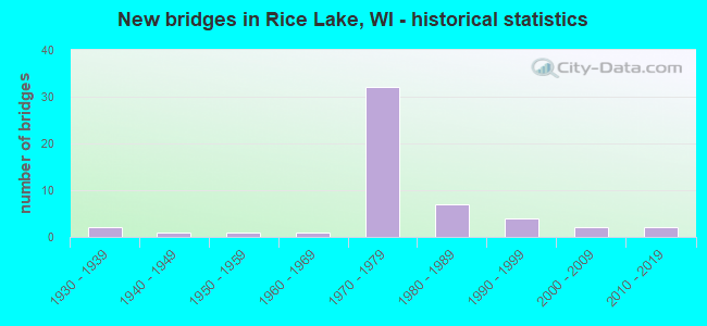
- New bridges - historical statistics
- 21930-1939
- 11940-1949
- 11950-1959
- 11960-1969
- 321970-1979
- 71980-1989
- 41990-1999
- 22000-2009
- 22010-2019


- Bridge Condition - Deck
- 2.6%Excellent
- 5.3%Very good
- 23.7%Good
- 52.6%Satisfactory
- 15.8%Fair

- Bridge Condition - Superstructure
- 2.6%Excellent
- 10.5%Very good
- 52.6%Good
- 26.3%Satisfactory
- 7.9%Fair

- Bridge Condition - Substructure
- 5.3%Excellent
- 7.9%Very good
- 50.0%Good
- 26.3%Satisfactory
- 10.5%Fair

- Bridge Condition - Channel
- 3.4%Excellent
- 62.1%Very good
- 31.0%Good
- 3.4%Satisfactory

- Bridge Condition - Culverts
- 66.7%Good
- 33.3%Satisfactory
Find on map >> Show street view
Structure Number: B030045, Location: 0.1M E JCT USH 53 TO S (Lat: 45.473003, Lng: -91.758517), Route carried "under" structure: County highway , Year Built: 1977, Structure Length: 0. m, Average Daily Traffic: 15,500 (year 2019), Features Intersected: CTH O, Facility Carried by Structure: USH 53 NB
Minimum Vertical Clearance: 4.85m (15.91ft), Kilometerpoint: 0.000, Lanes on structure: 2, Lanes under structure: 2, Material/Design: Prestressed concrete continuous, Design/Construction: Stringer/Multi-beam, Length of Maximum Span: 25.3m (83.0ft)
Find on map >> Show street view
Structure Number: B030046, Location: 7.3M N JCT USH 8 TO E (Lat: 45.494967, Lng: -91.764428), Route carried "under" structure: US 53, Year Built: 1977, Structure Length: 0. m, Average Daily Traffic: 12,600 (year 2019), Truck Traffic: 8%, Features Intersected: USH 53, Facility Carried by Structure: LRD ALLEN ST
Minimum Vertical Clearance: 5.12m (16.80ft), Kilometerpoint: 0.000, Lanes on structure: 2, Lanes under structure: 4, Material/Design: Prestressed concrete continuous, Design/Construction: Stringer/Multi-beam, Length of Maximum Span: 39.8m (130.6ft)
Find on map >> Show street view
Structure Number: B030047, Location: 7.8M N JCT USH 8 TO E (Lat: 45.502128, Lng: -91.764111), Route carried "under" structure: US 53, Year Built: 1977, Structure Length: 0. m, Average Daily Traffic: 12,600 (year 2019), Truck Traffic: 8%, Features Intersected: USH 53, Facility Carried by Structure: LRD AUGUSTA ST
Minimum Vertical Clearance: 5.12m (16.80ft), Kilometerpoint: 0.000, Lanes on structure: 2, Lanes under structure: 4, Material/Design: Steel continuous, Design/Construction: Stringer/Multi-beam, Length of Maximum Span: 38.6m (126.6ft)
Find on map >> Show street view
Structure Number: B030048, Location: 4.2M E JCT STH 25 (Lat: 45.509603, Lng: -91.762031), Route carried "under" structure: State highway 48, Year Built: 1977, Structure Length: 0. m, Average Daily Traffic: 8,400 (year 2019), Truck Traffic: 8%, Features Intersected: STH 48-KNAPP ST, Facility Carried by Structure: USH 53 SB
Minimum Vertical Clearance: 4.60m (15.09ft), Kilometerpoint: 0.000, Lanes on structure: 2, Lanes under structure: 4, Material/Design: Prestressed concrete continuous, Design/Construction: Stringer/Multi-beam, Length of Maximum Span: 30.6m (100.4ft)
Find on map >> Show street view
Structure Number: B030049, Location: 4.2M E JCT STH 25 (Lat: 45.509044, Lng: -91.761594), Route carried "under" structure: State highway 48, Year Built: 1977, Structure Length: 0. m, Average Daily Traffic: 8,400 (year 2019), Truck Traffic: 8%, Features Intersected: STH 48-KNAPP ST, Facility Carried by Structure: USH 53 NB
Minimum Vertical Clearance: 5.05m (16.57ft), Kilometerpoint: 0.000, Lanes on structure: 2, Lanes under structure: 4, Material/Design: Prestressed concrete continuous, Design/Construction: Stringer/Multi-beam, Length of Maximum Span: 31.2m (102.4ft)
Find on map >> Show street view
Structure Number: B03005, Location: 1.1M W JCT STH 48 (Lat: 45.531058, Lng: -91.760242), Route carried "under" structure: City street , Year Built: 1976, Structure Length: 0. m, Average Daily Traffic: 2,000 (year 2019), Features Intersected: LRD OAK LAWN RD, Facility Carried by Structure: USH 53 SB
Minimum Vertical Clearance: 4.45m (14.60ft), Kilometerpoint: 0.000, Lanes on structure: 2, Lanes under structure: 2, Material/Design: Concrete continuous, Design/Construction: Slab, Length of Maximum Span: 16.2m (53.1ft)
Find on map >> Show street view
Structure Number: B030051, Location: 1.1M W JCT STH 48 (Lat: 45.530700, Lng: -91.759525), Route carried "under" structure: City street , Year Built: 1976, Structure Length: 0. m, Average Daily Traffic: 2,000 (year 2019), Features Intersected: LRD OAK LAWN RD, Facility Carried by Structure: USH 53 NB
Minimum Vertical Clearance: 4.62m (15.16ft), Kilometerpoint: 0.000, Lanes on structure: 2, Lanes under structure: 2, Material/Design: Concrete continuous, Design/Construction: Slab, Length of Maximum Span: 16.2m (53.1ft)
Find on map >> Show street view
Structure Number: B030054, Location: 3.7M N JCT USH 8 TO E (Lat: 45.444531, Lng: -91.760031), Route carried "under" structure: US 53, Year Built: 1977, Structure Length: 0. m, Average Daily Traffic: 12,400 (year 2019), Truck Traffic: 8%, Features Intersected: USH 53, Facility Carried by Structure: LRD 16 1/2 AVE
Minimum Vertical Clearance: 5.03m (16.50ft), Kilometerpoint: 0.000, Lanes on structure: 2, Lanes under structure: 4, Material/Design: Steel continuous, Design/Construction: Stringer/Multi-beam, Length of Maximum Span: 35.8m (117.5ft)