Bridge Statistics for Rensselaer, Indiana (IN)
Condition, Traffic, Stress, Structural Evaluation, Project Costs
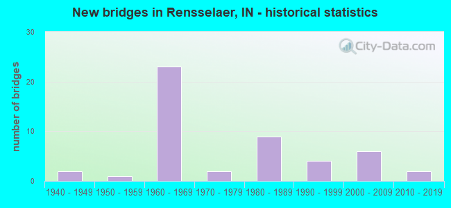
- New bridges - historical statistics
- 21940-1949
- 11950-1959
- 231960-1969
- 21970-1979
- 91980-1989
- 41990-1999
- 62000-2009
- 22010-2019

- Reconstructed bridges - Historical Statistics
- 11970-1979
- 01980-1989
- 101990-1999
- 12000-2009
- 22010-2019


- Bridge Condition - Deck
- 2.5%Very good
- 27.5%Good
- 55.0%Satisfactory
- 15.0%Fair

- Bridge Condition - Superstructure
- 5.0%Excellent
- 2.5%Very good
- 22.5%Good
- 47.5%Satisfactory
- 22.5%Fair

- Bridge Condition - Substructure
- 2.5%Excellent
- 10.0%Very good
- 37.5%Good
- 42.5%Satisfactory
- 7.5%Fair

- Bridge Condition - Channel
- 13.5%Very good
- 45.9%Good
- 29.7%Satisfactory
- 5.4%Fair
- 5.4%Poor
Find on map >> Show street view
Structure Number: 370015, Location: 00.04 E OF PARKE AVE (Lat: 40.932361, Lng: -87.152000), Route carried "on" structure: City street , Year Built: 1965, Status: Open, Structure Length: 2.44m (8.01ft), Average Daily Traffic: 868 (year 2012), Truck Traffic: 3%, Average Future Daily Traffic: 1,237 (year 2032), Features Intersected: IROQUOIS RIVER, Facility Carried by Structure: GRACE STREET
Minimum Vertical Clearance: 30+ m (98+ ft), Kilometerpoint: 0.000, Lanes on structure: 2, Owner: County Highway Agency, Approaching Roadway Width: 9.1m (29.9ft), Skew: 2 degrees, Navigation Control: Yes ( Vertical Clearance: 4.0m (13.1ft), Horizontal Clearance: 10.7m (35.1ft)), Material/Design: Prestressed concrete, Design/Construction: Box Beam or Girders - Multiple, Number Of Spans In Main Unit: 1, Length of Maximum Span: 23.6m (77.4ft), Curb or Sidewalk Widths: Left: 1.2m (3.9ft), Right: 1.2m (3.9ft), Curb-To-Curb Width: 9.3m (30.5ft), Out-to-Out Width: 12.3m (40.4ft)
Condition: Deck: Satisfactory, Superstructure: Satisfactory, Substructure: Satisfactory, Channel: Satisfactory, Operating Rating: 72.7 metric tons, Method Used To Determine Operating Rating: Load Factor (LF), Inventory Rating: 33.8 metric tons, Method Used To Determine Inventory Rating: Load Factor (LF), Structural Evaluation: Equal to present minimum criteria, Deck Geometry: Equal to present minimum criteria, Waterway Adequacy: Equal to present desirable criteria, Approach Roadway Alignment: Equal to present desirable criteria, Designated Inspection Frequency: Every 24 months, Inspection Date: August 2020, Deck Structure Type: Concrete Cast-file-Place, Wearing Surface/Protective System: Wearing Surface: Bituminous
Find on map >> Show street view
Structure Number: 3700151, Location: 00.10 N OF MILROY AVE (Lat: 40.936611, Lng: -87.156139), Route carried "on" structure: City street , Year Built: 1999, Status: Open, Structure Length: 2.68m (8.79ft), Average Daily Traffic: 4,242 (year 2019), Truck Traffic: 3%, Average Future Daily Traffic: 6,046 (year 2039), Design Load: HS 20, Features Intersected: IROQUOIS RIVER, Facility Carried by Structure: COLLEGE AVENUE
Minimum Vertical Clearance: 30+ m (98+ ft), Kilometerpoint: 0.000, Lanes on structure: 2, Owner: County Highway Agency, Approaching Roadway Width: 11.0m (36.1ft), Navigation Control: Yes ( Vertical Clearance: 3.7m (12.1ft), Horizontal Clearance: 9.8m (32.2ft)), Material/Design: Concrete continuous, Design/Construction: Slab, Number Of Spans In Main Unit: 3, Length of Maximum Span: 10.5m (34.4ft), Curb or Sidewalk Widths: Left: 1.5m (4.9ft), Right: 1.5m (4.9ft), Curb-To-Curb Width: 10.1m (33.1ft), Out-to-Out Width: 14.0m (45.9ft)
Condition: Deck: Satisfactory, Superstructure: Satisfactory, Substructure: Satisfactory, Channel: Satisfactory, Operating Rating: 55.1 metric tons, Method Used To Determine Operating Rating: Load Factor (LF), Inventory Rating: 33.0 metric tons, Method Used To Determine Inventory Rating: Load Factor (LF), Structural Evaluation: Equal to present minimum criteria, Deck Geometry: Meets minimum limits, Waterway Adequacy: Better than present minimum criteria, Approach Roadway Alignment: Equal to present desirable criteria, Designated Inspection Frequency: Every 24 months, Inspection Date: August 2020, Deck Structure Type: Concrete Cast-file-Place, Wearing Surface/Protective System: Wearing Surface: Monolithic Concrete, Deck Protection: Epoxy Coated Reinforcing
Find on map >> Show street view
Structure Number: 2565, Location: 03.83 W US-231 (Lat: 40.940731, Lng: -87.220917), Route carried "under" structure: Interstate 65, Year Built: 1966, Structure Length: 0. m, Average Daily Traffic: 17,860 (year 2020), Truck Traffic: 56%, Features Intersected: I-65 NBL, Facility Carried by Structure: SR 114
Minimum Vertical Clearance: 4.90m (16.08ft), Kilometerpoint: 344.786, Lanes on structure: 2, Lanes under structure: 4, Material/Design: Steel continuous, Design/Construction: Stringer/Multi-beam, Length of Maximum Span: 30.5m (100.1ft)
Find on map >> Show street view
Structure Number: 2565, Location: 03.83 W US-231 (Lat: 40.940731, Lng: -87.220917), Route carried "under" structure: Interstate 65, Year Built: 1966, Structure Length: 0. m, Average Daily Traffic: 18,581 (year 2020), Truck Traffic: 56%, Features Intersected: I-65 SBL, Facility Carried by Structure: SR 114
Minimum Vertical Clearance: 4.90m (16.08ft), Kilometerpoint: 344.786, Lanes on structure: 2, Lanes under structure: 4, Material/Design: Steel continuous, Design/Construction: Stringer/Multi-beam, Length of Maximum Span: 30.5m (100.1ft)
Find on map >> Show street view
Structure Number: 381, Location: 02.04 S SR 114 (Lat: 40.911669, Lng: -87.213333), Route carried "under" structure: Interstate 65, Year Built: 1966, Structure Length: 0. m, Average Daily Traffic: 24,961 (year 2004), Truck Traffic: 5%, Features Intersected: I 65 NBL, Facility Carried by Structure: CR 700S
Minimum Vertical Clearance: 4.95m (16.24ft), Kilometerpoint: 341.503, Lanes on structure: 2, Lanes under structure: 4, Material/Design: Steel continuous, Design/Construction: Stringer/Multi-beam, Length of Maximum Span: 21.3m (69.9ft)
Find on map >> Show street view
Structure Number: 381, Location: 02.04 S SR 114 (Lat: 40.911669, Lng: -87.213333), Route carried "under" structure: Interstate 65, Year Built: 1966, Structure Length: 0. m, Average Daily Traffic: 24,961 (year 2004), Truck Traffic: 5%, Features Intersected: I 65 SBL, Facility Carried by Structure: CR 700S
Minimum Vertical Clearance: 4.95m (16.24ft), Kilometerpoint: 341.503, Lanes on structure: 2, Lanes under structure: 4, Material/Design: Steel continuous, Design/Construction: Stringer/Multi-beam, Length of Maximum Span: 21.3m (69.9ft)
Find on map >> Show street view
Structure Number: 3811, Location: 01.00 S SR-114 (Lat: 40.926269, Lng: -87.218269), Route carried "under" structure: Interstate 65, Year Built: 1966, Structure Length: 0. m, Average Daily Traffic: 24,961 (year 2004), Truck Traffic: 5%, Features Intersected: I 65 NBL, Facility Carried by Structure: CR 600S
Minimum Vertical Clearance: 4.95m (16.24ft), Kilometerpoint: 343.177, Lanes on structure: 2, Lanes under structure: 4, Material/Design: Steel continuous, Design/Construction: Stringer/Multi-beam, Length of Maximum Span: 30.2m (99.1ft)
Find on map >> Show street view
Structure Number: 3811, Location: 01.00 S SR-114 (Lat: 40.926269, Lng: -87.218269), Route carried "under" structure: Interstate 65, Year Built: 1966, Structure Length: 0. m, Average Daily Traffic: 24,961 (year 2004), Truck Traffic: 5%, Features Intersected: I 65 SBL, Facility Carried by Structure: CR 600S
Minimum Vertical Clearance: 4.95m (16.24ft), Kilometerpoint: 343.177, Lanes on structure: 2, Lanes under structure: 4, Material/Design: Steel continuous, Design/Construction: Stringer/Multi-beam, Length of Maximum Span: 30.2m (99.1ft)
Find on map >> Show street view
Structure Number: 3814, Location: 01.89 N SR 114 (Lat: 40.963969, Lng: -87.238053), Route carried "under" structure: Interstate 65, Year Built: 1966, Structure Length: 0. m, Average Daily Traffic: 13,890 (year 2004), Truck Traffic: 20%, Features Intersected: I-65 SBL, Facility Carried by Structure: CR 1000W
Minimum Vertical Clearance: 4.95m (16.24ft), Kilometerpoint: 347.828, Lanes on structure: 2, Lanes under structure: 4, Material/Design: Steel continuous, Design/Construction: Stringer/Multi-beam, Length of Maximum Span: 32.3m (106.0ft)
Find on map >> Show street view
Structure Number: 3814, Location: 01.89 N SR 114 (Lat: 40.963969, Lng: -87.238053), Route carried "under" structure: Interstate 65, Year Built: 1966, Structure Length: 0. m, Average Daily Traffic: 13,890 (year 2004), Truck Traffic: 20%, Features Intersected: I-65 NBL, Facility Carried by Structure: CR 1000W
Minimum Vertical Clearance: 4.95m (16.24ft), Kilometerpoint: 347.828, Lanes on structure: 2, Lanes under structure: 4, Material/Design: Steel continuous, Design/Construction: Stringer/Multi-beam, Length of Maximum Span: 32.3m (106.0ft)