Bridge Statistics for Palmer, Texas (TX)
Condition, Traffic, Stress, Structural Evaluation, Project Costs
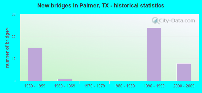
- New bridges - historical statistics
- 151950-1959
- 11960-1969
- 241990-1999
- 82000-2009


- Bridge Condition - Deck
- 83.3%Good
- 10.0%Satisfactory
- 6.7%Fair

- Bridge Condition - Superstructure
- 23.3%Very good
- 53.3%Good
- 20.0%Satisfactory
- 3.3%Poor

- Bridge Condition - Substructure
- 3.3%Very good
- 73.3%Good
- 20.0%Satisfactory
- 3.3%Fair

- Bridge Condition - Channel
- 2.4%Very good
- 31.0%Good
- 33.3%Satisfactory
- 31.0%Fair
- 2.4%Poor

- Bridge Condition - Culverts
- 20.0%Good
- 60.0%Satisfactory
- 20.0%Fair
Find on map >> Show street view
Structure Number: 180710AA0571001, Location: 0.90 MI NW OF IH45 BUS (Lat: 32.450397, Lng: -96.670892), Route carried "on" structure: County highway , Year Built: 2005, Status: Open, Structure Length: 2.59m (8.50ft), Average Daily Traffic: 576 (year 2014), Average Future Daily Traffic: 1,000 (year 2031), Design Load: HL 93, Features Intersected: Red Oak Creek, Facility Carried by Structure: Palmyra Road
Minimum Vertical Clearance: 30+ m (98+ ft), Kilometerpoint: 1.448, Lanes on structure: 2, Owner: County Highway Agency, Approaching Roadway Width: 6.1m (20.0ft), Material/Design: Prestressed concrete, Number Of Spans In Main Unit: 1, Number Of Approach Spans: 2, Length of Maximum Span: 10.7m (35.1ft), Curb-To-Curb Width: 8.4m (27.6ft), Out-to-Out Width: 9.2m (30.2ft)
Condition: Deck: Good, Superstructure: Very good, Substructure: Good, Channel: Satisfactory, Operating Rating: 54.4 metric tons, Method Used To Determine Operating Rating: Assigned ratings based on Load and Resistance Factor Design (LRFD) reported in metric tons, Inventory Rating: 32.7 metric tons, Method Used To Determine Inventory Rating: Assigned ratings based on Load and Resistance Factor Design (LRFD) reported in metric tons, Structural Evaluation: Better than present minimum criteria, Deck Geometry: Somewhat better than minimum adequacy, Waterway Adequacy: Meets minimum limits, Approach Roadway Alignment: Equal to present minimum criteria, Designated Inspection Frequency: Every 24 months, Inspection Date: December 2020, Deck Structure Type: Concrete Cast-file-Place
Find on map >> Show street view
Structure Number: 180710G00125001, Location: 0.25 MI S OF FM 813 (Lat: 32.427508, Lng: -96.666200), Route carried "on" structure: City street , Year Built: 1999, Status: Open, Structure Length: 0.82m (2.69ft), Average Daily Traffic: 134 (year 2011), Truck Traffic: 2%, Average Future Daily Traffic: 200 (year 2031), Design Load: HS 20, Features Intersected: FOUNTAIN CREEK, Facility Carried by Structure: STACKS STREET
Minimum Vertical Clearance: 30+ m (98+ ft), Kilometerpoint: 0.402, Lanes on structure: 2, Owner: City or Municipal Highway Agency, Approaching Roadway Width: 6.1m (20.0ft), Skew: 1 degrees, Material/Design: Concrete, Design/Construction: Culvert, Number Of Spans In Main Unit: 3, Length of Maximum Span: 2.4m (7.9ft), Curb-To-Curb Width: 9.1m (29.9ft), Out-to-Out Width: 9.7m (31.8ft)
Condition: Channel: Good, Culverts: Good, Operating Rating: 39.9 metric tons, Method Used To Determine Operating Rating: Load Factor (LF), Inventory Rating: 23.6 metric tons, Method Used To Determine Inventory Rating: Load Factor (LF), Structural Evaluation: Equal to present minimum criteria, Deck Geometry: Equal to present minimum criteria, Waterway Adequacy: Better than present minimum criteria, Approach Roadway Alignment: Equal to present desirable criteria, Designated Inspection Frequency: Every 24 months, Inspection Date: Febuary 2021, Deck Structure Type: Concrete Cast-file-Place, Wearing Surface/Protective System: Wearing Surface: Bituminous
Find on map >> Show street view
Structure Number: 180710009204273, Location: 2.9 MI N OF FM 879 (Lat: 32.416736, Lng: -96.660253), Route carried "under" structure: Interstate 45, Year Built: 1992, Structure Length: 0. m, Average Daily Traffic: 42,460 (year 2013), Truck Traffic: 22%, Features Intersected: IH 45 ML
Minimum Vertical Clearance: 5.51m (18.08ft), Kilometerpoint: 23.104, Lanes on structure: 2, Lanes under structure: 6, Material/Design: Prestressed concrete, Design/Construction: Stringer/Multi-beam, Length of Maximum Span: 32.0m (105.0ft)
Find on map >> Show street view
Structure Number: 180710009204274, Location: 4.2 MI N OF FM 879 (Lat: 32.433236, Lng: -96.660175), Route carried "under" structure: Interstate 45, Year Built: 1992, Structure Length: 0. m, Average Daily Traffic: 42,460 (year 2013), Truck Traffic: 22%, Features Intersected: IH 45, Facility Carried by Structure: FM 813
Minimum Vertical Clearance: 5.21m (17.09ft), Kilometerpoint: 24.982, Lanes on structure: 2, Lanes under structure: 10, Material/Design: Prestressed concrete, Design/Construction: Stringer/Multi-beam, Length of Maximum Span: 25.9m (85.0ft)
Find on map >> Show street view
Structure Number: 180710009204276, Location: 0.9 MI N OF FM 813 (Lat: 32.446444, Lng: -96.664708), Route carried "under" structure: Interstate 45, Year Built: 1992, Structure Length: 0. m, Average Daily Traffic: 39,580 (year 2013), Truck Traffic: 22%, Features Intersected: IH 45 ML
Minimum Vertical Clearance: 5.54m (18.18ft), Kilometerpoint: 26.493, Lanes on structure: 2, Lanes under structure: 6, Material/Design: Prestressed concrete, Design/Construction: Box Beam or Girders - Multiple, Length of Maximum Span: 30.5m (100.1ft)