Bridge Statistics for North Ridgeville, Ohio (OH)
Condition, Traffic, Stress, Structural Evaluation, Project Costs
- National Bridge Inventory (NBI) Statistics
- 70Number of bridges
- 715ft / 218mTotal length
- $450,000Total costs
- 1,294,109Total average daily traffic
- 149,231Total average daily truck traffic
- National Bridge Inventory (NBI) Registered Bridges for North Ridgeville
- No street view available for this location
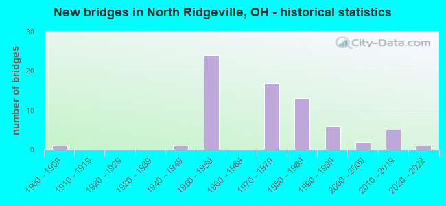
- New bridges - historical statistics
- 11900-1909
- 11940-1949
- 241950-1959
- 171970-1979
- 131980-1989
- 61990-1999
- 22000-2009
- 52010-2019
- 12020-2022

- Reconstructed bridges - Historical Statistics
- 11920-1929
- 01930-1939
- 01940-1949
- 01950-1959
- 01960-1969
- 31970-1979
- 41980-1989
- 51990-1999
- 12000-2009


- Bridge Condition - Deck
- 15.4%Excellent
- 2.6%Very good
- 66.7%Good
- 5.1%Satisfactory
- 5.1%Fair
- 2.6%Poor
- 2.6%Serious

- Bridge Condition - Superstructure
- 12.8%Excellent
- 7.7%Very good
- 56.4%Good
- 12.8%Satisfactory
- 7.7%Fair
- 2.6%Serious

- Bridge Condition - Substructure
- 15.4%Excellent
- 12.8%Very good
- 33.3%Good
- 28.2%Satisfactory
- 5.1%Fair
- 2.6%Poor
- 2.6%Serious

- Bridge Condition - Channel
- 26.3%Excellent
- 5.3%Very good
- 36.8%Good
- 21.1%Satisfactory
- 5.3%Fair
- 5.3%Poor

- Bridge Condition - Culverts
- 12.5%Excellent
- 25.0%Good
- 50.0%Satisfactory
- 12.5%Poor
Find on map >> Show street view
Structure Number: 4740483, Location: .07MI.WEST OF (Lat: 41.374211, Lng: -82.033200), Route carried "on" structure: City street M0087, Year Built: 1991, Status: Open, Structure Length: 0.73m (2.40ft), Average Daily Traffic: 14,095 (year 2015), Truck Traffic: 3%, Average Future Daily Traffic: 19,564 (year 2035), Design Load: HS 20, Features Intersected: CREEK SUGAR RIDGE, Facility Carried by Structure: SUGAR RIDGE RD.
Minimum Vertical Clearance: 30+ m (98+ ft), Kilometerpoint: 3.347, Lanes on structure: 2, Owner: County Highway Agency, Approaching Roadway Width: 6.4m (21.0ft), Skew: 3 degrees, Material/Design: Prestressed concrete, Design/Construction: Box Beam or Girders - Multiple, Number Of Spans In Main Unit: 1, Length of Maximum Span: 6.1m (20.0ft), Curb-To-Curb Width: 9.8m (32.2ft), Out-to-Out Width: 9.8m (32.2ft)
Condition: Deck: Fair, Superstructure: Fair, Substructure: Fair, Channel: Satisfactory, Operating Rating: 42.1 metric tons, Method Used To Determine Operating Rating: Load Factor (LF) rating reported by rating factor (RF) method using MS18 loading, Inventory Rating: 32.4 metric tons, Method Used To Determine Inventory Rating: Load Factor (LF) rating reported by rating factor (RF) method using MS18 loading, Structural Evaluation: Somewhat better than minimum adequacy, Deck Geometry: Meets minimum limits, Waterway Adequacy: Equal to present desirable criteria, Approach Roadway Alignment: Equal to present minimum criteria, Designated Inspection Frequency: Every 12 months, Inspection Date: October 2021, Deck Structure Type: Concrete Cast-file-Place, Wearing Surface/Protective System: Wearing Surface: Bituminous, Membrane: Built-up
Find on map >> Show street view
Structure Number: 4770002, Location: 0.22 MI W OF SR83 (Lat: 41.410411, Lng: -82.024339), Route carried "on" structure: City street FUTRA, Year Built: 2015, Status: Open, Structure Length: 0.85m (2.79ft), Average Daily Traffic: 500 (year 2015), Truck Traffic: 2%, Average Future Daily Traffic: 694 (year 2035), Design Load: HL 93, Features Intersected: SAYE DITCH, Facility Carried by Structure: WEST SHORE PARKWAY
Minimum Vertical Clearance: 30+ m (98+ ft), Kilometerpoint: 0.000, Lanes on structure: 2, Owner: City or Municipal Highway Agency, Approaching Roadway Width: 7.9m (25.9ft), Material/Design: Concrete, Design/Construction: Culvert, Number Of Spans In Main Unit: 2, Length of Maximum Span: 3.7m (12.1ft), Curb or Sidewalk Widths: Left: 1.5m (4.9ft), Right: 1.5m (4.9ft)
Condition: Channel: Very good, Culverts: Good, Operating Rating: 50.9 metric tons, Method Used To Determine Operating Rating: Load and Resistance Factor Rating (LRFR) rating reported by rating factor(RF) method using HL-93 loadings, Inventory Rating: 39.2 metric tons, Method Used To Determine Inventory Rating: Load and Resistance Factor Rating (LRFR) rating reported by rating factor(RF) method using HL-93 loadings, Structural Evaluation: Better than present minimum criteria, Waterway Adequacy: Better than present minimum criteria, Approach Roadway Alignment: Equal to present minimum criteria, Designated Inspection Frequency: Every 24 months, Inspection Date: May 2021
Find on map >> Show street view
Structure Number: 4774477, Location: 285 FT W OF MANNING CIR (Lat: 41.415339, Lng: -82.014169), Route carried "on" structure: City street M0001, Year Built: 1977, Year Reconstructed: 2007, Status: Open, Structure Length: 0.82m (2.69ft), Average Daily Traffic: 100 (year 2017), Truck Traffic: 2%, Average Future Daily Traffic: 694 (year 2012), Design Load: HS 20+Mod, Features Intersected: FRENCH CREEK-CHESTERFIEL, Facility Carried by Structure: CHESTERFIELD CIR.
Minimum Vertical Clearance: 30+ m (98+ ft), Kilometerpoint: 0.241, Lanes on structure: 2, Owner: City or Municipal Highway Agency, Approaching Roadway Width: 7.9m (25.9ft), Material/Design: Prestressed concrete, Design/Construction: Box Beam or Girders - Multiple, Number Of Spans In Main Unit: 1, Length of Maximum Span: 7.9m (25.9ft), Curb or Sidewalk Widths: Left: 1.3m (4.3ft), Right: 1.3m (4.3ft), Curb-To-Curb Width: 7.9m (25.9ft), Out-to-Out Width: 11.2m (36.7ft)
Condition: Deck: Good, Superstructure: Good, Substructure: Satisfactory, Channel: Good, Operating Rating: 97.2 metric tons, Method Used To Determine Operating Rating: Load Factor (LF) rating reported by rating factor (RF) method using MS18 loading, Inventory Rating: 61.6 metric tons, Method Used To Determine Inventory Rating: Load Factor (LF) rating reported by rating factor (RF) method using MS18 loading, Structural Evaluation: Equal to present minimum criteria, Deck Geometry: Equal to present minimum criteria, Waterway Adequacy: Equal to present desirable criteria, Approach Roadway Alignment: Better than present minimum criteria, Length Of Structure Improvement: 1.83m (6.00ft), Designated Inspection Frequency: Every 12 months, Inspection Date: October 2021, Bridge Improvement Cost: $170,000, Roadway Improvement Cost: $20,000, Total Project Cost: $210,000, Deck Structure Type: Concrete Cast-file-Place, Wearing Surface/Protective System: Wearing Surface: Monolithic Concrete
Find on map >> Show street view
Structure Number: 4774639, Location: 0.10 MI SOUTH OF IR 80 (Lat: 41.378111, Lng: -82.031889), Route carried "on" structure: City street M0146, Year Built: 1953, Status: Open, Structure Length: 1.16m (3.81ft), Average Daily Traffic: 1,650 (year 2015), Truck Traffic: 3%, Average Future Daily Traffic: 2,290 (year 2011), Design Load: H 20, Features Intersected: RIDGEWAY DITCH-MADDOCK R, Facility Carried by Structure: MADDOCK ROAD
Minimum Vertical Clearance: 30+ m (98+ ft), Kilometerpoint: 0.370, Lanes on structure: 2, Owner: City or Municipal Highway Agency, Approaching Roadway Width: 7.6m (24.9ft), Material/Design: Concrete, Design/Construction: Culvert, Number Of Spans In Main Unit: 2, Length of Maximum Span: 4.9m (16.1ft)
Condition: Channel: Satisfactory, Culverts: Satisfactory, Operating Rating: 45.4 metric tons, Method Used To Determine Operating Rating: Load and Resistance Factor Rating (LRFR) rating reported by rating factor(RF) method using HL-93 loadings, Inventory Rating: 35.6 metric tons, Method Used To Determine Inventory Rating: Load and Resistance Factor Rating (LRFR) rating reported by rating factor(RF) method using HL-93 loadings, Structural Evaluation: Equal to present minimum criteria, Waterway Adequacy: Equal to present desirable criteria, Approach Roadway Alignment: Equal to present desirable criteria, Length Of Structure Improvement: 1.83m (6.00ft), Designated Inspection Frequency: Every 12 months, Inspection Date: October 2021, Bridge Improvement Cost: $30,000, Roadway Improvement Cost: $10,000, Total Project Cost: $50,000
Find on map >> Show street view
Structure Number: 4774698, Location: 0.10 MI E OF SR 83 (Lat: 41.399581, Lng: -82.016939), Route carried "on" structure: City street M0002, Year Built: 1971, Status: Open, Structure Length: 0.67m (2.20ft), Average Daily Traffic: 100 (year 2019), Truck Traffic: 3%, Average Future Daily Traffic: 1,110 (year 2011), Design Load: H 20, Features Intersected: FRENCH CREEK-MILDRED ST, Facility Carried by Structure: MILDRED ST
Minimum Vertical Clearance: 30+ m (98+ ft), Kilometerpoint: 0.161, Lanes on structure: 2, Owner: City or Municipal Highway Agency, Approaching Roadway Width: 7.9m (25.9ft), Skew: 1 degrees, Material/Design: Concrete, Design/Construction: Slab, Number Of Spans In Main Unit: 1, Length of Maximum Span: 5.5m (18.0ft), Curb or Sidewalk Widths: Left: 1.5m (4.9ft), Right: 1.5m (4.9ft), Curb-To-Curb Width: 8.2m (26.9ft), Out-to-Out Width: 11.1m (36.4ft)
Condition: Deck: Satisfactory, Superstructure: Satisfactory, Substructure: Satisfactory, Channel: Satisfactory, Operating Rating: 77.8 metric tons, Method Used To Determine Operating Rating: Load Factor (LF) rating reported by rating factor (RF) method using MS18 loading, Inventory Rating: 48.6 metric tons, Method Used To Determine Inventory Rating: Load Factor (LF) rating reported by rating factor (RF) method using MS18 loading, Structural Evaluation: Equal to present minimum criteria, Deck Geometry: Equal to present minimum criteria, Waterway Adequacy: Equal to present desirable criteria, Approach Roadway Alignment: Equal to present desirable criteria, Length Of Structure Improvement: 1.52m (4.99ft), Designated Inspection Frequency: Every 12 months, Inspection Date: October 2021, Bridge Improvement Cost: $160,000, Roadway Improvement Cost: $10,000, Total Project Cost: $190,000, Deck Structure Type: Concrete Cast-file-Place, Wearing Surface/Protective System: Wearing Surface: Bituminous
Find on map >> Show street view
Structure Number: 4774753, Location: 0.28 MI EAST OF SR 83 (Lat: 41.418800, Lng: -82.013411), Route carried "on" structure: City street M0003, Year Built: 2021, Status: Open, Structure Length: 0.82m (2.69ft), Average Daily Traffic: 6,910 (year 2020), Truck Traffic: 5%, Average Future Daily Traffic: 7,250 (year 2040), Design Load: HL 93, Features Intersected: FRENCH CREEK, Facility Carried by Structure: MILLS ROAD
Minimum Vertical Clearance: 30+ m (98+ ft), Kilometerpoint: 2.253, Lanes on structure: 2, Owner: City or Municipal Highway Agency, Approaching Roadway Width: 8.5m (27.9ft), Material/Design: Concrete, Design/Construction: Frame, Number Of Spans In Main Unit: 1, Length of Maximum Span: 7.6m (24.9ft), Curb or Sidewalk Widths: Left: 1.5m (4.9ft), Right: 1.5m (4.9ft), Curb-To-Curb Width: 8.5m (27.9ft), Out-to-Out Width: 12.2m (40.0ft)
Condition: Deck: Excellent, Superstructure: Excellent, Substructure: Excellent, Channel: Excellent, Operating Rating: 58.0 metric tons, Method Used To Determine Operating Rating: Load and Resistance Factor Rating (LRFR) rating reported by rating factor(RF) method using HL-93 loadings, Inventory Rating: 44.7 metric tons, Method Used To Determine Inventory Rating: Load and Resistance Factor Rating (LRFR) rating reported by rating factor(RF) method using HL-93 loadings, Structural Evaluation: Superior to present desirable criteria, Deck Geometry: High priority of replacement, Waterway Adequacy: Better than present minimum criteria, Approach Roadway Alignment: Equal to present desirable criteria, Designated Inspection Frequency: Every 12 months, Inspection Date: January 2022, Deck Structure Type: Other, Wearing Surface/Protective System: Wearing Surface: Monolithic Concrete, Membrane: Preformed Fabric
Find on map >> Show street view
Structure Number: 477476, Location: 0.2 MI E. OF BAGLEY ROAD (Lat: 41.375181, Lng: -81.989089), Route carried "on" structure: City street M0010, Year Built: 1998, Status: Open, Structure Length: 7.91m (25.95ft), Average Daily Traffic: 13,716 (year 2019), Truck Traffic: 4%, Average Future Daily Traffic: 20,166 (year 2035), Design Load: HS 20+Mod, Features Intersected: CONRAIL RR - LORAIN ROAD, Facility Carried by Structure: LORAIN ROAD
Minimum Vertical Clearance: 30+ m (98+ ft), Kilometerpoint: 16.044, Lanes on structure: 4, Owner: City or Municipal Highway Agency, Approaching Roadway Width: 15.9m (52.2ft), Skew: 4 degrees, Material/Design: Steel continuous, Design/Construction: Stringer/Multi-beam, Number Of Spans In Main Unit: 3, Length of Maximum Span: 29.7m (97.4ft), Curb or Sidewalk Widths: Left: 2.0m (6.6ft), Right: 2.0m (6.6ft), Curb-To-Curb Width: 15.9m (52.2ft), Out-to-Out Width: 20.4m (66.9ft)
Condition: Deck: Good, Superstructure: Good, Substructure: Good, Operating Rating: 32.4 metric tons, Method Used To Determine Operating Rating: Load and Resistance Factor Rating (LRFR) rating reported by rating factor(RF) method using HL-93 loadings, Inventory Rating: 22.7 metric tons, Method Used To Determine Inventory Rating: Load and Resistance Factor Rating (LRFR) rating reported by rating factor(RF) method using HL-93 loadings, Structural Evaluation: Somewhat better than minimum adequacy, Deck Geometry: Meets minimum limits, Underclear: Equal to present minimum criteria, Approach Roadway Alignment: Equal to present minimum criteria, Designated Inspection Frequency: Every 24 months, Inspection Date: October 2021, Deck Structure Type: Concrete Cast-file-Place, Wearing Surface/Protective System: Wearing Surface: Monolithic Concrete, Membrane: Epoxy, Deck Protection: Epoxy Coated Reinforcing
Find on map >> Show street view
Structure Number: 4774973, Location: 70 FT W OF KENSSINGTON DR (Lat: 41.385181, Lng: -82.006519), Route carried "on" structure: City street BAINB, Year Built: 1996, Status: Open, Structure Length: 1.13m (3.71ft), Average Daily Traffic: 8,038 (year 2019), Truck Traffic: 5%, Average Future Daily Traffic: 10,063 (year 2035), Design Load: HS 20+Mod, Features Intersected: FRENCH CREEK
Minimum Vertical Clearance: 30+ m (98+ ft), Kilometerpoint: 1.014, Lanes on structure: 2, Owner: City or Municipal Highway Agency, Approaching Roadway Width: 8.5m (27.9ft), Skew: 3 degrees, Material/Design: Prestressed concrete, Design/Construction: Box Beam or Girders - Multiple, Number Of Spans In Main Unit: 1, Length of Maximum Span: 11.0m (36.1ft), Curb or Sidewalk Widths: Left: 1.7m (5.6ft), Right: 1.7m (5.6ft), Curb-To-Curb Width: 8.4m (27.6ft), Out-to-Out Width: 12.4m (40.7ft)
Condition: Deck: Good, Superstructure: Good, Substructure: Good, Channel: Good, Operating Rating: 81.0 metric tons, Method Used To Determine Operating Rating: Load Factor (LF) rating reported by rating factor (RF) method using MS18 loading, Inventory Rating: 45.4 metric tons, Method Used To Determine Inventory Rating: Load Factor (LF) rating reported by rating factor (RF) method using MS18 loading, Structural Evaluation: Better than present minimum criteria, Deck Geometry: High priority of replacement, Waterway Adequacy: Equal to present desirable criteria, Approach Roadway Alignment: Equal to present desirable criteria, Designated Inspection Frequency: Every 24 months, Inspection Date: October 2021, Deck Structure Type: Concrete Cast-file-Place, Wearing Surface/Protective System: Wearing Surface: Monolithic Concrete, Deck Protection: Epoxy Coated Reinforcing
Find on map >> Show street view
Structure Number: 4775589, Location: 0.2 MI E OF LEAR-NAGLE (Lat: 41.390261, Lng: -81.978231), Route carried "on" structure: City street CYPRS, Year Built: 1999, Status: Open, Structure Length: 0.95m (3.12ft), Average Daily Traffic: 100 (year 2020), Truck Traffic: 1%, Average Future Daily Traffic: 139 (year 2025), Design Load: HS 20, Features Intersected: MILLS DITCH-CYPRESS AVE., Facility Carried by Structure: CYPRESS AVE
Minimum Vertical Clearance: 30+ m (98+ ft), Kilometerpoint: 0.306, Lanes on structure: 2, Owner: City or Municipal Highway Agency, Approaching Roadway Width: 9.1m (29.9ft), Skew: 4 degrees, Material/Design: Concrete, Design/Construction: Culvert, Number Of Spans In Main Unit: 1, Length of Maximum Span: 8.6m (28.2ft)
Condition: Channel: Good, Culverts: Good, Operating Rating: 64.8 metric tons, Method Used To Determine Operating Rating: Load Factor (LF) rating reported by rating factor (RF) method using MS18 loading, Inventory Rating: 51.8 metric tons, Method Used To Determine Inventory Rating: Load Factor (LF) rating reported by rating factor (RF) method using MS18 loading, Structural Evaluation: Better than present minimum criteria, Waterway Adequacy: Better than present minimum criteria, Approach Roadway Alignment: Equal to present desirable criteria, Designated Inspection Frequency: Every 24 months, Inspection Date: October 2021
Find on map >> Show street view
Structure Number: 4701496, Location: 5.05 MILES EAST OF SR 57 (Lat: 41.378361, Lng: -81.990669), Route carried "under" structure: Interstate 80K, Year Built: 1979, Structure Length: 0. m, Average Daily Traffic: 35,651 (year 2015), Truck Traffic: 14%, Features Intersected: NB SR 10, Facility Carried by Structure: I80 OH TPK
Minimum Vertical Clearance: 5.14m (16.86ft), Kilometerpoint: 31.656, Lanes on structure: 2, Lanes under structure: 6, Toll: On toll road, Material/Design: Steel continuous, Design/Construction: Stringer/Multi-beam, Length of Maximum Span: 34.1m (111.9ft)
Find on map >> Show street view
Structure Number: 4701518, Location: 5.05 MILES EAST OF SR 57 (Lat: 41.378481, Lng: -81.990850), Route carried "under" structure: Interstate 80K, Year Built: 1979, Structure Length: 0. m, Average Daily Traffic: 35,651 (year 2015), Truck Traffic: 14%, Features Intersected: SB SR 10, Facility Carried by Structure: I80 OH TPK
Minimum Vertical Clearance: 5.77m (18.93ft), Kilometerpoint: 31.624, Lanes on structure: 2, Lanes under structure: 6, Toll: On toll road, Material/Design: Steel continuous, Design/Construction: Stringer/Multi-beam, Length of Maximum Span: 33.2m (108.9ft)
Find on map >> Show street view
Structure Number: 4704118, Location: 2.59 MILES EAST OF SR 57 (Lat: 41.353019, Lng: -82.025431), Route carried "under" structure: State highway 10, Year Built: 1979, Structure Length: 0. m, Average Daily Traffic: 27,145 (year 2015), Truck Traffic: 10%, Features Intersected: UNDER LOR-083D-0010, Facility Carried by Structure: SR 83C
Minimum Vertical Clearance: 4.70m (15.42ft), Kilometerpoint: 4.056, Lanes on structure: 2, Lanes under structure: 4, Material/Design: Steel continuous, Design/Construction: Stringer/Multi-beam, Length of Maximum Span: 17.7m (58.1ft)
Find on map >> Show street view
Structure Number: 4707559, Location: 1.05 MI E OF OHIO TNPK (Lat: 41.382931, Lng: -81.988450), Route carried "under" structure: City street 25, Year Built: 1980, Structure Length: 0. m, Average Daily Traffic: 2,717 (year 2015), Truck Traffic: 3%, Features Intersected: UNDER LOR-480-0115L, Facility Carried by Structure: IR 480
Minimum Vertical Clearance: 4.40m (14.44ft), Kilometerpoint: 98.975, Lanes on structure: 2, Lanes under structure: 2, Material/Design: Steel continuous, Design/Construction: Stringer/Multi-beam, Length of Maximum Span: 21.3m (69.9ft)
Find on map >> Show street view
Structure Number: 4707567, Location: .2 MI. WEST OF RT.10 (Lat: 41.381750, Lng: -81.989319), Route carried "under" structure: City street 25, Year Built: 1980, Structure Length: 0. m, Average Daily Traffic: 2,717 (year 2015), Truck Traffic: 3%, Features Intersected: UNDER LOR-480-0105R, Facility Carried by Structure: IR 480
Minimum Vertical Clearance: 4.50m (14.76ft), Kilometerpoint: 97.687, Lanes on structure: 2, Lanes under structure: 2, Material/Design: Steel continuous, Design/Construction: Stringer/Multi-beam, Length of Maximum Span: 15.2m (49.9ft)
Find on map >> Show street view
Structure Number: 4707583, Location: .45 MI W OF CUY CO LINE (Lat: 41.387119, Lng: -81.978881), Route carried "under" structure: City street 55, Year Built: 1980, Structure Length: 0. m, Average Daily Traffic: 6,903 (year 2015), Truck Traffic: 5%, Features Intersected: UNDER LOR-480-0172, Facility Carried by Structure: IR 480
Minimum Vertical Clearance: 4.43m (14.53ft), Kilometerpoint: 12.875, Lanes on structure: 6, Lanes under structure: 2, Material/Design: Steel continuous, Design/Construction: Stringer/Multi-beam, Length of Maximum Span: 20.7m (67.9ft)
Find on map >> Show street view
Structure Number: 4707591, Location: 1.21 MILES E OF OHIO TNPK (Lat: 41.382269, Lng: -81.987239), Route carried "under" structure: State highway 10, Year Built: 1980, Structure Length: 0. m, Average Daily Traffic: 34,875 (year 2015), Truck Traffic: 10%, Features Intersected: UNDER LOR-480-0121R, Facility Carried by Structure: IR 480
Minimum Vertical Clearance: 5.01m (16.44ft), Kilometerpoint: 8.787, Lanes on structure: 2, Lanes under structure: 2, Material/Design: Steel continuous, Design/Construction: Stringer/Multi-beam, Length of Maximum Span: 24.7m (81.0ft)
Find on map >> Show street view
Structure Number: 4707613, Location: .08 MILES WEST OF CUY CO (Lat: 41.388381, Lng: -81.973081), Route carried "under" structure: State highway 10, Year Built: 1980, Structure Length: 0. m, Average Daily Traffic: 1,970 (year 2015), Truck Traffic: 11%, Features Intersected: UNDER LOR-480-0209, Facility Carried by Structure: IR 480
Minimum Vertical Clearance: 4.57m (14.99ft), Kilometerpoint: 10.799, Lanes on structure: 7, Lanes under structure: 4, Material/Design: Steel continuous, Design/Construction: Stringer/Multi-beam, Length of Maximum Span: 22.3m (73.2ft)
Find on map >> Show street view
Structure Number: 4708431, Location: 2.86 MILES NORTH OF SR 82 (Lat: 41.355531, Lng: -82.019361), Route carried "under" structure: State highway 10, Year Built: 1979, Structure Length: 0. m, Average Daily Traffic: 34,875 (year 2015), Truck Traffic: 10%, Features Intersected: UNDER LOR-083-1078, Facility Carried by Structure: SR 83
Minimum Vertical Clearance: 4.60m (15.09ft), Kilometerpoint: 4.764, Lanes on structure: 2, Lanes under structure: 4, Material/Design: Steel continuous, Design/Construction: Stringer/Multi-beam, Length of Maximum Span: 24.4m (80.1ft)
Find on map >> Show street view
Structure Number: 4708474, Location: 4.36 MILES EAST OF SR 57 (Lat: 41.371019, Lng: -82.000019), Route carried "under" structure: County highway 24, Year Built: 1979, Structure Length: 0. m, Average Daily Traffic: 5,854 (year 2015), Truck Traffic: 7%, Features Intersected: UNDER LOR-010-1962L, Facility Carried by Structure: SR 10
Minimum Vertical Clearance: 4.47m (14.67ft), Kilometerpoint: 6.051, Lanes on structure: 2, Lanes under structure: 2, Material/Design: Concrete continuous, Design/Construction: Slab, Length of Maximum Span: 14.9m (48.9ft)
Find on map >> Show street view
Structure Number: 4708482, Location: 4.36 MILES EAST OF SR 57 (Lat: 41.370900, Lng: -81.999900), Route carried "under" structure: County highway 24, Year Built: 1979, Structure Length: 0. m, Average Daily Traffic: 5,854 (year 2015), Truck Traffic: 7%, Features Intersected: UNDER LOR-010-1962R, Facility Carried by Structure: SR 10
Minimum Vertical Clearance: 4.37m (14.34ft), Kilometerpoint: 6.035, Lanes on structure: 2, Lanes under structure: 2, Material/Design: Concrete continuous, Design/Construction: Slab, Length of Maximum Span: 14.9m (48.9ft)
Find on map >> Show street view
Structure Number: 4729617, Location: 2.5MI EAST OF EXIT 145 (Lat: 41.380681, Lng: -82.067019), Route carried "under" structure: US 20, Year Built: 1954, Structure Length: 0. m, Average Daily Traffic: 12,054 (year 2015), Truck Traffic: 4%, Features Intersected: I80 OHIO TPK
Minimum Vertical Clearance: 4.57m (14.99ft), Kilometerpoint: 27.954, Lanes on structure: 6, Lanes under structure: 3, Material/Design: Steel, Design/Construction: Stringer/Multi-beam, Length of Maximum Span: 26.5m (86.9ft)
Find on map >> Show street view
Structure Number: 4729676, Location: 3.7MI EAST OF EXIT 8 (Lat: 41.378400, Lng: -82.044419), Route carried "under" structure: Interstate 80K, Year Built: 1954, Structure Length: 0. m, Average Daily Traffic: 51,503 (year 2015), Truck Traffic: 14%, Features Intersected: RACE RD, Facility Carried by Structure: I80 OHIO TPK
Minimum Vertical Clearance: 4.48m (14.70ft), Kilometerpoint: 25.347, Lanes on structure: 2, Lanes under structure: 6, Toll: On toll road, Material/Design: Steel continuous, Design/Construction: Stringer/Multi-beam, Length of Maximum Span: 20.1m (65.9ft)
Find on map >> Show street view
Structure Number: 4729714, Location: 4.3MI EAST OF EXIT 8 (Lat: 41.379531, Lng: -82.031919), Route carried "under" structure: Interstate 80K, Year Built: 1954, Structure Length: 0. m, Average Daily Traffic: 51,503 (year 2015), Truck Traffic: 14%, Features Intersected: MADDOCK RD, Facility Carried by Structure: I80 OHIO TPK
Minimum Vertical Clearance: 4.50m (14.76ft), Kilometerpoint: 28.019, Lanes on structure: 2, Lanes under structure: 6, Toll: On toll road, Material/Design: Steel continuous, Design/Construction: Stringer/Multi-beam, Length of Maximum Span: 20.1m (65.9ft)
Find on map >> Show street view
Structure Number: 4729757, Location: 5MI EAST OF EXIT 9 (Lat: 41.379931, Lng: -82.018711), Route carried "under" structure: Interstate 80K, Year Built: 1954, Structure Length: 0. m, Average Daily Traffic: 51,503 (year 2015), Truck Traffic: 14%, Features Intersected: SR83, Facility Carried by Structure: I80 OHIO TPK
Minimum Vertical Clearance: 4.47m (14.67ft), Kilometerpoint: 29.113, Lanes on structure: 2, Lanes under structure: 6, Toll: On toll road, Material/Design: Steel continuous, Design/Construction: Stringer/Multi-beam, Length of Maximum Span: 20.1m (65.9ft)
Find on map >> Show street view
Structure Number: 4729765, Location: 5.6MI EAST OF EXIT 8 (Lat: 41.379331, Lng: -82.006850), Route carried "under" structure: Interstate 80K, Year Built: 1996, Structure Length: 0. m, Average Daily Traffic: 51,503 (year 2015), Truck Traffic: 14%, Features Intersected: ROOT RD MP 1511, Facility Carried by Structure: ROOT ROAD
Minimum Vertical Clearance: 4.75m (15.58ft), Kilometerpoint: 30.111, Lanes on structure: 2, Lanes under structure: 7, Toll: On toll road, Material/Design: Steel continuous, Design/Construction: Stringer/Multi-beam, Length of Maximum Span: 45.7m (149.9ft)
Find on map >> Show street view
Structure Number: 4729811, Location: AT EXIT 9A (Lat: 41.379000, Lng: -81.995300), Route carried "under" structure: Interstate 80K, Year Built: 1981, Structure Length: 0. m, Average Daily Traffic: 51,503 (year 2015), Truck Traffic: 14%, Features Intersected: I-480 EB RAMP OVER TPK, Facility Carried by Structure: I80 OHIO TURNPIKE
Minimum Vertical Clearance: 5.04m (16.54ft), Kilometerpoint: 31.125, Lanes on structure: 2, Lanes under structure: 6, Toll: On toll road, Material/Design: Steel continuous, Design/Construction: Stringer/Multi-beam, Length of Maximum Span: 34.1m (111.9ft)
Find on map >> Show street view
Structure Number: 4729838, Location: 6.5MI EAST OF EXIT 145 (Lat: 41.379031, Lng: -81.991250), Route carried "under" structure: County highway 25, Year Built: 1954, Structure Length: 0. m, Average Daily Traffic: 2,717 (year 2015), Truck Traffic: 3%, Features Intersected: I80 OHIO TPK, Facility Carried by Structure: CHESTNUT RIDGE RD
Minimum Vertical Clearance: 4.42m (14.50ft), Kilometerpoint: 9.318, Lanes on structure: 6, Lanes under structure: 2, Material/Design: Steel continuous, Design/Construction: Stringer/Multi-beam, Length of Maximum Span: 11.9m (39.0ft)
Find on map >> Show street view
Structure Number: 4729854, Location: 0.2MI WEST OF EXIT 9 (Lat: 41.378761, Lng: -81.991361), Route carried "under" structure: County highway 25, Year Built: 1954, Structure Length: 0. m, Average Daily Traffic: 2,717 (year 2015), Truck Traffic: 3%, Features Intersected: I80 OHIO TPK, Facility Carried by Structure: RAMP OVER CHESTNUT
Minimum Vertical Clearance: 4.44m (14.57ft), Kilometerpoint: 160.918, Lanes on structure: 1, Lanes under structure: 2, Material/Design: Steel continuous, Design/Construction: Stringer/Multi-beam, Length of Maximum Span: 11.6m (38.1ft)
Find on map >> Show street view
Structure Number: 4729862, Location: 0.1MI WEST OF EXIT 152 (Lat: 41.378419, Lng: -81.987819), Route carried "under" structure: Ramp Interstate 80K, Year Built: 1954, Structure Length: 0. m, Features Intersected: I80 OHIO TURNPIKE, Facility Carried by Structure: TPK EXIT 152 RAMP
Minimum Vertical Clearance: 4.78m (15.68ft), Kilometerpoint: 23.673, Lanes on structure: 7, Lanes under structure: 2, Toll: On toll road, Material/Design: Steel continuous, Design/Construction: Stringer/Multi-beam, Length of Maximum Span: 12.5m (41.0ft)
Find on map >> Show street view
Structure Number: 4729897, Location: 0.1MI EAST OF EXIT 152 (Lat: 41.377781, Lng: -81.986111), Route carried "under" structure: County highway C0012, Year Built: 1954, Structure Length: 0. m, Average Daily Traffic: 14,529 (year 2015), Truck Traffic: 4%, Features Intersected: I80 OHIO TPK, Facility Carried by Structure: LORAIN RD
Minimum Vertical Clearance: 4.57m (14.99ft), Kilometerpoint: 23.834, Lanes on structure: 6, Lanes under structure: 4, Material/Design: Steel continuous, Design/Construction: Stringer/Multi-beam, Length of Maximum Span: 16.2m (53.1ft)
Find on map >> Show street view
Structure Number: 4729943, Location: 0.1MI EAST OF EXIT 9 (Lat: 41.380000, Lng: -81.983331), Route carried "under" structure: County highway C12, Year Built: 1954, Structure Length: 0. m, Average Daily Traffic: 14,529 (year 2015), Truck Traffic: 4%, Features Intersected: TPK EXIT 152 RAMP, Facility Carried by Structure: LORAIN RD
Minimum Vertical Clearance: 4.52m (14.83ft), Kilometerpoint: 33.635, Lanes on structure: 2, Lanes under structure: 5, Material/Design: Steel continuous, Design/Construction: Stringer/Multi-beam, Length of Maximum Span: 15.5m (50.9ft)
Find on map >> Show street view
Structure Number: 4729951, Location: 0.7MI EAST OF EXIT 9 (Lat: 41.371750, Lng: -81.975600), Route carried "under" structure: Interstate 80K, Year Built: 1954, Structure Length: 0. m, Average Daily Traffic: 37,444 (year 2015), Truck Traffic: 14%, Features Intersected: BAGLEY RD, Facility Carried by Structure: I80 OHIO TPK
Minimum Vertical Clearance: 4.70m (15.42ft), Kilometerpoint: 32.975, Lanes on structure: 2, Lanes under structure: 6, Toll: On toll road, Material/Design: Steel continuous, Design/Construction: Stringer/Multi-beam, Length of Maximum Span: 24.4m (80.1ft)