Bridge Statistics for Newcomerstown, Ohio (OH)
Condition, Traffic, Stress, Structural Evaluation, Project Costs
- National Bridge Inventory (NBI) Statistics
- 55Number of bridges
- 558ft / 170mTotal length
- $118,741,000Total costs
- 233,410Total average daily traffic
- 39,735Total average daily truck traffic
- National Bridge Inventory (NBI) Registered Bridges for Newcomerstown
- No street view available for this location
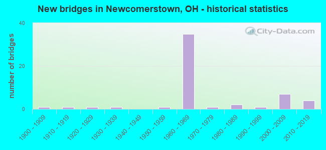
- New bridges - historical statistics
- 11900-1909
- 11910-1919
- 11920-1929
- 11930-1939
- 11950-1959
- 351960-1969
- 11970-1979
- 21980-1989
- 11990-1999
- 72000-2009
- 42010-2019

- Reconstructed bridges - Historical Statistics
- 11970-1979
- 51980-1989
- 21990-1999
- 12000-2009
- 22010-2019
- 12020-2022


- Bridge Condition - Deck
- 21.4%Excellent
- 23.8%Very good
- 33.3%Good
- 16.7%Satisfactory
- 4.8%Fair

- Bridge Condition - Superstructure
- 23.8%Excellent
- 19.0%Very good
- 35.7%Good
- 16.7%Satisfactory
- 2.4%Fair
- 2.4%Poor

- Bridge Condition - Substructure
- 28.6%Excellent
- 16.7%Very good
- 33.3%Good
- 14.3%Satisfactory
- 4.8%Fair
- 2.4%Poor

- Bridge Condition - Channel
- 6.5%Excellent
- 19.4%Very good
- 19.4%Good
- 51.6%Satisfactory
- 3.2%Fair
Find on map >> Show street view
Structure Number: 7934483, Location: .5 MI S OF JCT CR 23 (Lat: 40.318269, Lng: -81.571761), Route carried "on" structure: County highway T0215, Year Built: 2002, Status: Open, Structure Length: 1.25m (4.10ft), Average Daily Traffic: 209 (year 2015), Truck Traffic: 7%, Average Future Daily Traffic: 290 (year 2035), Design Load: HS 20+Mod, Features Intersected: BUCKHORN CREEK, Facility Carried by Structure: SALEM TR 215
Minimum Vertical Clearance: 30+ m (98+ ft), Kilometerpoint: 3.685, Lanes on structure: 2, Owner: County Highway Agency, Approaching Roadway Width: 5.2m (17.1ft), Material/Design: Prestressed concrete, Design/Construction: Box Beam or Girders - Multiple, Number Of Spans In Main Unit: 1, Length of Maximum Span: 12.2m (40.0ft), Curb-To-Curb Width: 7.3m (24.0ft), Out-to-Out Width: 7.3m (24.0ft)
Condition: Deck: Excellent, Superstructure: Excellent, Substructure: Excellent, Channel: Satisfactory, Operating Rating: 42.1 metric tons, Method Used To Determine Operating Rating: Load and Resistance Factor Rating (LRFR) rating reported by rating factor(RF) method using HL-93 loadings, Inventory Rating: 32.4 metric tons, Method Used To Determine Inventory Rating: Load and Resistance Factor Rating (LRFR) rating reported by rating factor(RF) method using HL-93 loadings, Structural Evaluation: Equal to present desirable criteria, Deck Geometry: Somewhat better than minimum adequacy, Waterway Adequacy: Equal to present desirable criteria, Approach Roadway Alignment: Equal to present desirable criteria, Designated Inspection Frequency: Every 24 months, Inspection Date: January 2021, Deck Structure Type: Concrete Cast-file-Place, Wearing Surface/Protective System: Wearing Surface: Bituminous, Membrane: Preformed Fabric, Deck Protection: Other
Find on map >> Show street view
Structure Number: 7934572, Location: 400 FEET WEST OF CR-20 (Lat: 40.332431, Lng: -81.594450), Route carried "on" structure: County highway T0224, Year Built: 2000, Status: Open, Structure Length: 0.82m (2.69ft), Average Daily Traffic: 96 (year 2015), Truck Traffic: 7%, Average Future Daily Traffic: 133 (year 2035), Design Load: HS 20+Mod, Features Intersected: WEST FORK, Facility Carried by Structure: SALEM TR 224
Minimum Vertical Clearance: 30+ m (98+ ft), Kilometerpoint: 3.750, Lanes on structure: 2, Owner: County Highway Agency, Approaching Roadway Width: 5.5m (18.0ft), Material/Design: Concrete, Design/Construction: Box Beam or Girders - Multiple, Number Of Spans In Main Unit: 1, Length of Maximum Span: 7.9m (25.9ft), Curb-To-Curb Width: 7.3m (24.0ft), Out-to-Out Width: 7.3m (24.0ft)
Condition: Deck: Very good, Superstructure: Very good, Substructure: Very good, Channel: Very good, Operating Rating: 90.7 metric tons, Method Used To Determine Operating Rating: Load and Resistance Factor Rating (LRFR) rating reported by rating factor(RF) method using HL-93 loadings, Inventory Rating: 55.1 metric tons, Method Used To Determine Inventory Rating: Load and Resistance Factor Rating (LRFR) rating reported by rating factor(RF) method using HL-93 loadings, Structural Evaluation: Equal to present desirable criteria, Deck Geometry: Equal to present minimum criteria, Waterway Adequacy: Equal to present desirable criteria, Approach Roadway Alignment: Better than present minimum criteria, Designated Inspection Frequency: Every 24 months, Inspection Date: May 2021, Deck Structure Type: Concrete Cast-file-Place, Wearing Surface/Protective System: Wearing Surface: Bituminous, Membrane: Preformed Fabric, Deck Protection: Other
Find on map >> Show street view
Structure Number: 7936397, Location: 0.2MI E OF TUSC CO W LINE (Lat: 40.273550, Lng: -81.612339), Route carried "on" structure: City street 323, Year Built: 1913, Year Reconstructed: 1989, Status: Posted for load, Structure Length: 2.77m (9.09ft), Average Daily Traffic: 376 (year 1991), Truck Traffic: 3%, Average Future Daily Traffic: 522 (year 2011), Design Load: HS 20+Mod, Features Intersected: BUCKHORN CREEK, Facility Carried by Structure: NCT CANAL STREET
Minimum Vertical Clearance: 30+ m (98+ ft), Kilometerpoint: 8.546, Lanes on structure: 2, Owner: County Highway Agency, Approaching Roadway Width: 6.7m (22.0ft), Material/Design: Steel, Design/Construction: Truss - Thru, Number Of Spans In Main Unit: 1, Length of Maximum Span: 26.4m (86.6ft), Curb or Sidewalk Widths: Left: 1.5m (4.9ft), Right: 1.5m (4.9ft), Curb-To-Curb Width: 7.3m (24.0ft), Out-to-Out Width: 8.2m (26.9ft)
Condition: Deck: Good, Superstructure: Satisfactory, Substructure: Satisfactory, Channel: Satisfactory, Operating Rating: 32.4 metric tons, Method Used To Determine Operating Rating: Load Factor (LF) rating reported by rating factor (RF) method using MS18 loading, Inventory Rating: 16.2 metric tons, Method Used To Determine Inventory Rating: Load Factor (LF) rating reported by rating factor (RF) method using MS18 loading, Structural Evaluation: Somewhat better than minimum adequacy, Deck Geometry: Somewhat better than minimum adequacy, Waterway Adequacy: Better than present minimum criteria, Approach Roadway Alignment: Equal to present minimum criteria, Bridge Posting: Required (Relationship of Operating Rating to Maximum Legal Load: 30.0 - 39.9% below), Designated Inspection Frequency: Every 12 months, Critical Feature Inspection Frequency: Every 24 months, Inspection Date: June 2021, Critical Feature Inspection Date: November 2020, Deck Structure Type: Corrugated Steel, Wearing Surface/Protective System: Wearing Surface: Bituminous, Membrane: Preformed Fabric
Find on map >> Show street view
Structure Number: 7936451, Location: 800 FT N OF JCT NEIGHBOR (Lat: 40.279061, Lng: -81.607931), Route carried "on" structure: City street M0121, Year Built: 2008, Status: Open, Structure Length: 1.92m (6.30ft), Average Daily Traffic: 466 (year 2014), Truck Traffic: 8%, Average Future Daily Traffic: 647 (year 2034), Design Load: HS 20+Mod, Features Intersected: BUCKHORN CREEK, Facility Carried by Structure: CROSS STREET NCT
Minimum Vertical Clearance: 30+ m (98+ ft), Kilometerpoint: 8.208, Lanes on structure: 2, Owner: County Highway Agency, Approaching Roadway Width: 9.1m (29.9ft), Skew: 2 degrees, Material/Design: Prestressed concrete, Design/Construction: Box Beam or Girders - Multiple, Number Of Spans In Main Unit: 1, Length of Maximum Span: 18.9m (62.0ft), Curb or Sidewalk Widths: Left: 1.8m (5.9ft), Right: 1.8m (5.9ft), Curb-To-Curb Width: 9.1m (29.9ft), Out-to-Out Width: 13.4m (44.0ft)
Condition: Deck: Excellent, Superstructure: Excellent, Substructure: Excellent, Channel: Satisfactory, Operating Rating: 42.1 metric tons, Method Used To Determine Operating Rating: Load Factor (LF) rating reported by rating factor (RF) method using MS18 loading, Inventory Rating: 32.4 metric tons, Method Used To Determine Inventory Rating: Load Factor (LF) rating reported by rating factor (RF) method using MS18 loading, Structural Evaluation: Equal to present desirable criteria, Deck Geometry: Equal to present minimum criteria, Waterway Adequacy: Superior to present desirable criteria, Approach Roadway Alignment: Superior to present desirable criteria, Designated Inspection Frequency: Every 24 months, Inspection Date: April 2021, Deck Structure Type: Concrete Cast-file-Place, Wearing Surface/Protective System: Wearing Surface: Monolithic Concrete, Deck Protection: Epoxy Coated Reinforcing
Find on map >> Show street view
Structure Number: 790012, Location: 0.14 MI E OF COS. CO LINE (Lat: 40.283989, Lng: -81.617369), Route carried "under" structure: County highway 21, Year Built: 1968, Structure Length: 0. m, Average Daily Traffic: 332 (year 2015), Truck Traffic: 8%, Features Intersected: US 36, Facility Carried by Structure: US 36
Minimum Vertical Clearance: 4.75m (15.58ft), Kilometerpoint: 2.559, Lanes on structure: 4, Lanes under structure: 2, Material/Design: Steel continuous, Design/Construction: Stringer/Multi-beam, Length of Maximum Span: 16.8m (55.1ft)
Find on map >> Show street view
Structure Number: 7900155, Location: 0.91 MI E OF COS. CO LINE (Lat: 40.283750, Lng: -81.603011), Route carried "under" structure: City street CLLGE, Year Built: 1968, Structure Length: 0. m, Average Daily Traffic: 1,921 (year 2015), Truck Traffic: 5%, Features Intersected: US 36, Facility Carried by Structure: US 36
Minimum Vertical Clearance: 8.89m (29.17ft), Kilometerpoint: 1.127, Lanes on structure: 4, Lanes under structure: 2, Material/Design: Steel continuous, Design/Construction: Stringer/Multi-beam, Length of Maximum Span: 25.6m (84.0ft)
Find on map >> Show street view
Structure Number: 790186, Location: 0.97 MI N- GUERNSEY LINE (Lat: 40.233861, Lng: -81.553981), Route carried "under" structure: County highway 13, Year Built: 1967, Structure Length: 0. m, Average Daily Traffic: 268 (year 2015), Truck Traffic: 7%, Features Intersected: I 77, Facility Carried by Structure: IR 77 SOUTH
Minimum Vertical Clearance: 4.52m (14.83ft), Kilometerpoint: 2.414, Lanes on structure: 2, Lanes under structure: 2, Material/Design: Steel continuous, Design/Construction: Stringer/Multi-beam, Length of Maximum Span: 13.7m (44.9ft)
Find on map >> Show street view
Structure Number: 7901895, Location: 0.97 MI.N - GUERNSEY LINE (Lat: 40.233700, Lng: -81.553711), Route carried "under" structure: County highway 13, Year Built: 1967, Structure Length: 0. m, Average Daily Traffic: 268 (year 2015), Truck Traffic: 7%, Features Intersected: I 77, Facility Carried by Structure: IR 77 NORTH
Minimum Vertical Clearance: 4.47m (14.67ft), Kilometerpoint: 2.414, Lanes on structure: 2, Lanes under structure: 2, Material/Design: Steel continuous, Design/Construction: Stringer/Multi-beam, Length of Maximum Span: 13.7m (44.9ft)
Find on map >> Show street view
Structure Number: 7901984, Location: 1.33 MI. S. OF JCT SR258 (Lat: 40.255000, Lng: -81.552819), Route carried "under" structure: Interstate 77, Year Built: 1969, Structure Length: 0. m, Average Daily Traffic: 17,570 (year 2015), Truck Traffic: 24%, Features Intersected: CO RD 4, Facility Carried by Structure: C.R. 4
Minimum Vertical Clearance: 16.15m (52.99ft), Kilometerpoint: 3.943, Lanes on structure: 2, Lanes under structure: 4, Material/Design: Steel, Design/Construction: Arch - Deck, Length of Maximum Span: 70.1m (230.0ft)
Find on map >> Show street view
Structure Number: 7902018, Location: 1.50 MI. S. OF JCT. US36 (Lat: 40.271831, Lng: -81.544089), Route carried "under" structure: State highway 258, Year Built: 1969, Structure Length: 0. m, Average Daily Traffic: 479 (year 2015), Truck Traffic: 10%, Features Intersected: I 77, Facility Carried by Structure: IR 77
Minimum Vertical Clearance: 4.44m (14.57ft), Kilometerpoint: 4.812, Lanes on structure: 2, Lanes under structure: 2, Material/Design: Steel continuous, Design/Construction: Stringer/Multi-beam, Length of Maximum Span: 16.2m (53.1ft)
Find on map >> Show street view
Structure Number: 7902042, Location: 1.50 MI S. OF JCT. US36 (Lat: 40.271800, Lng: -81.543719), Route carried "under" structure: State highway 258, Year Built: 1969, Structure Length: 0. m, Average Daily Traffic: 479 (year 2015), Truck Traffic: 10%, Features Intersected: I 77, Facility Carried by Structure: IR 77
Minimum Vertical Clearance: 6.00m (19.69ft), Kilometerpoint: 4.844, Lanes on structure: 2, Lanes under structure: 2, Material/Design: Steel continuous, Design/Construction: Stringer/Multi-beam, Length of Maximum Span: 18.5m (60.7ft)
Find on map >> Show street view
Structure Number: 7902131, Location: 0.26 MI. S. OF JCT. US36 (Lat: 40.287481, Lng: -81.555550), Route carried "under" structure: City street 105, Year Built: 1969, Structure Length: 0. m, Average Daily Traffic: 47 (year 2015), Truck Traffic: 6%, Features Intersected: I 77, Facility Carried by Structure: IR 77
Minimum Vertical Clearance: 7.54m (24.74ft), Kilometerpoint: 2.704, Lanes on structure: 2, Lanes under structure: 2, Material/Design: Steel continuous, Design/Construction: Stringer/Multi-beam, Length of Maximum Span: 17.7m (58.1ft)
Find on map >> Show street view
Structure Number: 7902166, Location: 0.26 MI. S. OF JCT. US36 (Lat: 40.287619, Lng: -81.555219), Route carried "under" structure: County highway 105, Year Built: 1969, Structure Length: 0. m, Average Daily Traffic: 47 (year 2015), Truck Traffic: 6%, Features Intersected: I 77, Facility Carried by Structure: IR 77
Minimum Vertical Clearance: 7.54m (24.74ft), Kilometerpoint: 1.851, Lanes on structure: 2, Lanes under structure: 2, Material/Design: Steel continuous, Design/Construction: Stringer/Multi-beam, Length of Maximum Span: 17.7m (58.1ft)
Find on map >> Show street view
Structure Number: 790219, Location: 1.50 MI. N. OF SR258 (Lat: 40.290850, Lng: -81.557139), Route carried "under" structure: US 36, Year Built: 1969, Structure Length: 0. m, Average Daily Traffic: 8,880 (year 2015), Truck Traffic: 12%, Features Intersected: I 77, Facility Carried by Structure: IR 77
Minimum Vertical Clearance: 5.64m (18.50ft), Kilometerpoint: 5.729, Lanes on structure: 2, Lanes under structure: 4, Material/Design: Steel continuous, Design/Construction: Stringer/Multi-beam, Length of Maximum Span: 23.8m (78.1ft)
Find on map >> Show street view
Structure Number: 790222, Location: 1.50 MI. N. OF SR258 (Lat: 40.290981, Lng: -81.556819), Route carried "under" structure: US 36, Year Built: 1969, Structure Length: 0. m, Average Daily Traffic: 8,880 (year 2015), Truck Traffic: 12%, Features Intersected: I 77, Facility Carried by Structure: IR 77
Minimum Vertical Clearance: 5.12m (16.80ft), Kilometerpoint: 5.761, Lanes on structure: 3, Lanes under structure: 4, Material/Design: Steel continuous, Design/Construction: Stringer/Multi-beam, Length of Maximum Span: 23.5m (77.1ft)
Find on map >> Show street view
Structure Number: 7902255, Location: 2.27 MI. N. OF JCT. US36 (Lat: 40.321681, Lng: -81.569669), Route carried "under" structure: County highway 23, Year Built: 1969, Structure Length: 0. m, Average Daily Traffic: 330 (year 2015), Truck Traffic: 8%, Features Intersected: I 77, Facility Carried by Structure: IR 77
Minimum Vertical Clearance: 4.95m (16.24ft), Kilometerpoint: 24.623, Lanes on structure: 2, Lanes under structure: 2, Material/Design: Steel continuous, Design/Construction: Stringer/Multi-beam, Length of Maximum Span: 11.9m (39.0ft)
Find on map >> Show street view
Structure Number: 7902344, Location: 2.27 MI. N. OF JCT. US36 (Lat: 40.321669, Lng: -81.569381), Route carried "under" structure: County highway 23, Year Built: 1969, Structure Length: 0. m, Average Daily Traffic: 330 (year 2015), Truck Traffic: 8%, Features Intersected: I 77, Facility Carried by Structure: IR 77
Minimum Vertical Clearance: 4.83m (15.85ft), Kilometerpoint: 24.623, Lanes on structure: 2, Lanes under structure: 2, Material/Design: Steel continuous, Design/Construction: Stringer/Multi-beam, Length of Maximum Span: 11.9m (39.0ft)