Bridge Statistics for Morganton, North Carolina (NC)
Condition, Traffic, Stress, Structural Evaluation, Project Costs
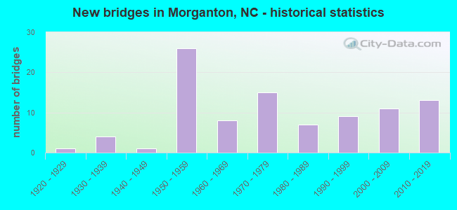
- New bridges - historical statistics
- 11920-1929
- 41930-1939
- 11940-1949
- 261950-1959
- 81960-1969
- 151970-1979
- 71980-1989
- 91990-1999
- 112000-2009
- 132010-2019

- Reconstructed bridges - Historical Statistics
- 81960-1969
- 21970-1979
- 11980-1989
- 11990-1999
- 12000-2009


- Bridge Condition - Deck
- 3.3%Excellent
- 3.3%Very good
- 50.8%Good
- 31.1%Satisfactory
- 9.8%Fair
- 1.6%Poor

- Bridge Condition - Superstructure
- 3.3%Excellent
- 9.8%Very good
- 42.6%Good
- 23.0%Satisfactory
- 11.5%Fair
- 8.2%Poor
- 1.6%Serious

- Bridge Condition - Substructure
- 3.3%Excellent
- 4.9%Very good
- 37.7%Good
- 32.8%Satisfactory
- 16.4%Fair
- 3.3%Poor
- 1.6%Serious

- Bridge Condition - Channel
- 3.1%Very good
- 64.6%Good
- 23.1%Satisfactory
- 9.2%Fair

- Bridge Condition - Culverts
- 22.2%Good
- 61.1%Satisfactory
- 5.6%Fair
- 11.1%Poor
Find on map >> Show street view
Structure Number: 230143, Location: .1 MI.N.JCT.SR1822 (Lat: 35.724089, Lng: -81.644583), Route carried "under" structure: Interstate 40, Year Built: 1955, Structure Length: 0. m, Average Daily Traffic: 22,000 (year 2015), Truck Traffic: 16%, Features Intersected: SR1708
Minimum Vertical Clearance: 4.67m (15.32ft), Kilometerpoint: 32.278, Lanes on structure: 2, Lanes under structure: 2, Material/Design: Steel, Design/Construction: Stringer/Multi-beam, Length of Maximum Span: 16.4m (53.8ft)
Find on map >> Show street view
Structure Number: 230143, Location: .1 MI.N.JCT.SR1822 (Lat: 35.724089, Lng: -81.644583), Route carried "under" structure: Interstate 40, Year Built: 1955, Structure Length: 0. m, Average Daily Traffic: 22,000 (year 2015), Truck Traffic: 16%, Features Intersected: SR1708
Minimum Vertical Clearance: 5.05m (16.57ft), Kilometerpoint: 32.278, Lanes on structure: 2, Lanes under structure: 2, Material/Design: Steel, Design/Construction: Stringer/Multi-beam, Length of Maximum Span: 16.4m (53.8ft)
Find on map >> Show street view
Structure Number: 230144, Location: .2 MI.N.JCT.SR1712 (Lat: 35.725314, Lng: -81.636347), Route carried "under" structure: Interstate 40, Year Built: 1955, Structure Length: 0. m, Average Daily Traffic: 22,500 (year 2015), Truck Traffic: 16%, Features Intersected: SR1704
Minimum Vertical Clearance: 5.13m (16.83ft), Kilometerpoint: 32.431, Lanes on structure: 2, Lanes under structure: 2, Material/Design: Steel, Design/Construction: Stringer/Multi-beam, Length of Maximum Span: 15.5m (50.9ft)
Find on map >> Show street view
Structure Number: 230144, Location: .2 MI.N.JCT.SR1712 (Lat: 35.725314, Lng: -81.636347), Route carried "under" structure: Interstate 40, Year Built: 1955, Structure Length: 0. m, Average Daily Traffic: 22,500 (year 2015), Truck Traffic: 16%, Features Intersected: SR1704
Minimum Vertical Clearance: 4.63m (15.19ft), Kilometerpoint: 32.757, Lanes on structure: 2, Lanes under structure: 2, Material/Design: Steel, Design/Construction: Stringer/Multi-beam, Length of Maximum Span: 15.5m (50.9ft)