Bridge Statistics for Mills River, North Carolina (NC)
Condition, Traffic, Stress, Structural Evaluation, Project Costs
- National Bridge Inventory (NBI) Statistics
- 46Number of bridges
- 564ft / 172mTotal length
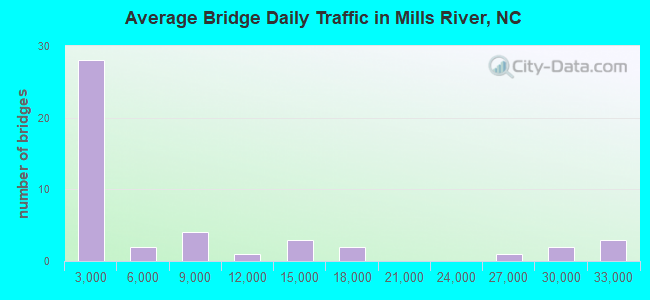
- 324,881Total average daily traffic
- 34,801Total average daily truck traffic
- 649,727Total future (year 2040) average daily traffic
- National Bridge Inventory (NBI) Registered Bridges for Mills River
- No street view available for this location
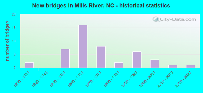
- New bridges - historical statistics
- 21930-1939
- 71950-1959
- 161960-1969
- 81970-1979
- 21980-1989
- 61990-1999
- 32000-2009
- 12010-2019
- 12020-2022
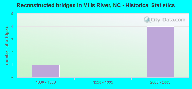
- Reconstructed bridges - Historical Statistics
- 11980-1989
- 01990-1999
- 42000-2009
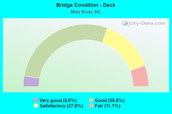
- Bridge Condition - Deck
- 5.6%Very good
- 55.6%Good
- 27.8%Satisfactory
- 11.1%Fair
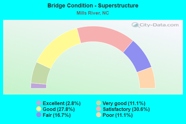
- Bridge Condition - Superstructure
- 2.8%Excellent
- 11.1%Very good
- 27.8%Good
- 30.6%Satisfactory
- 16.7%Fair
- 11.1%Poor
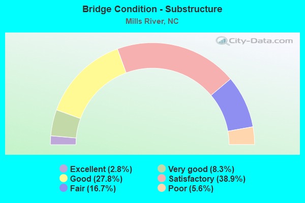
- Bridge Condition - Substructure
- 2.8%Excellent
- 8.3%Very good
- 27.8%Good
- 38.9%Satisfactory
- 16.7%Fair
- 5.6%Poor
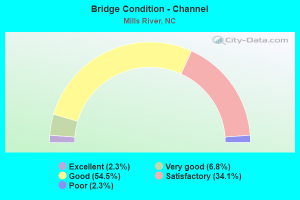
- Bridge Condition - Channel
- 2.3%Excellent
- 6.8%Very good
- 54.5%Good
- 34.1%Satisfactory
- 2.3%Poor
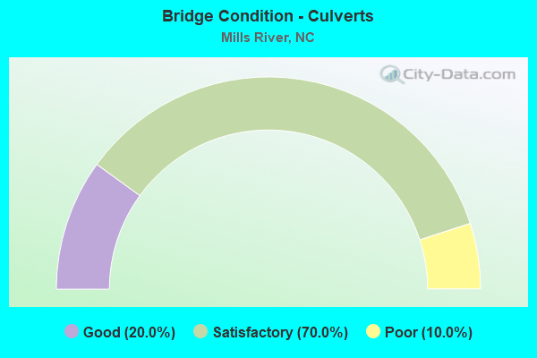
- Bridge Condition - Culverts
- 20.0%Good
- 70.0%Satisfactory
- 10.0%Poor
Find on map >> Show street view
Structure Number: 1750315, Location: .5 MI.E.JCT.SR1567 (Lat: 35.327069, Lng: -82.649547), Route carried "on" structure: Other road , Year Built: 1992, Status: Open, Structure Length: 0.64m (2.10ft), Average Daily Traffic: 1 (year 2007), Average Future Daily Traffic: 2 (year 2040), Design Load: HS 20+Mod, Features Intersected: BOYLSTON CREEK, Facility Carried by Structure: PRIVATE DRIVE
Minimum Vertical Clearance: 30+ m (98+ ft), Kilometerpoint: 0.000, Lanes on structure: 1, Owner: State Highway Agency, Approaching Roadway Width: 3.3m (10.8ft), Material/Design: Concrete continuous, Design/Construction: Culvert, Number Of Spans In Main Unit: 2, Length of Maximum Span: 3.0m (9.8ft)
Condition: Channel: Good, Culverts: Good, Operating Rating: 39.0 metric tons, Method Used To Determine Operating Rating: Load and Resistance Factor (LRFR), Inventory Rating: 29.9 metric tons, Method Used To Determine Inventory Rating: Load and Resistance Factor (LRFR), Structural Evaluation: Better than present minimum criteria, Waterway Adequacy: Better than present minimum criteria, Approach Roadway Alignment: Equal to present desirable criteria, Designated Inspection Frequency: Every 24 months, Inspection Date: September 2020
Find on map >> Show street view
Structure Number: 81107000003092, Location: 11.4 MI. E. JCT. RD 475 (Lat: 35.406628, Lng: -82.649564), Route carried "on" structure: Federal lands road 1206, Year Built: 1978, Status: Open, Structure Length: 1.37m (4.49ft), Average Daily Traffic: 40 (year 1980), Average Future Daily Traffic: 60 (year 2042), Features Intersected: NORTH MILLS RIVER
Minimum Vertical Clearance: 30+ m (98+ ft), Kilometerpoint: 18.560, Lanes on structure: 1, Owner: U.S. Forest Service, Approaching Roadway Width: 3.7m (12.1ft), Material/Design: Steel, Design/Construction: Stringer/Multi-beam, Number Of Spans In Main Unit: 1, Length of Maximum Span: 12.8m (42.0ft), Curb or Sidewalk Widths: Left: 0.3m (1.0ft), Right: 0.3m (1.0ft), Curb-To-Curb Width: 4.3m (14.1ft), Out-to-Out Width: 4.9m (16.1ft)
Condition: Deck: Good, Superstructure: Good, Substructure: Satisfactory, Channel: Good, Operating Rating: 65.8 metric tons, Method Used To Determine Operating Rating: Load and Resistance Factor Rating (LRFR) rating reported by rating factor(RF) method using HL-93 loadings, Inventory Rating: 50.5 metric tons, Method Used To Determine Inventory Rating: Load and Resistance Factor Rating (LRFR) rating reported by rating factor(RF) method using HL-93 loadings, Structural Evaluation: Equal to present minimum criteria, Deck Geometry: Equal to present minimum criteria, Waterway Adequacy: Better than present minimum criteria, Approach Roadway Alignment: Equal to present desirable criteria, Designated Inspection Frequency: Every 24 months, Critical Feature Inspection Frequency: Every 24 months, Inspection Date: July 2021, Critical Feature Inspection Date: July 2021, Deck Structure Type: Concrete Cast-file-Place, Wearing Surface/Protective System: Wearing Surface: Other
Find on map >> Show street view
Structure Number: 81107000003097, Location: 75' S. JCT. FS RD 1206 (Lat: 35.406719, Lng: -82.649019), Route carried "on" structure: Federal lands road 294.0, Year Built: 1939, Status: Open, Structure Length: 1.34m (4.40ft), Average Daily Traffic: 30 (year 1980), Average Future Daily Traffic: 45 (year 2042), Features Intersected: NORTH MILLS RIVER, Facility Carried by Structure: NFSR 294
Minimum Vertical Clearance: 30+ m (98+ ft), Kilometerpoint: 0.001, Lanes on structure: 2, Owner: U.S. Forest Service, Approaching Roadway Width: 5.2m (17.1ft), Material/Design: Concrete, Design/Construction: Arch - Deck, Number Of Spans In Main Unit: 1, Length of Maximum Span: 13.4m (44.0ft), Curb or Sidewalk Widths: Left: 0.4m (1.3ft), Right: 0.4m (1.3ft), Curb-To-Curb Width: 5.8m (19.0ft), Out-to-Out Width: 6.6m (21.7ft)
Condition: Deck: Satisfactory, Superstructure: Satisfactory, Substructure: Good, Channel: Satisfactory, Operating Rating: 18.5 metric tons, Method Used To Determine Operating Rating: Load and Resistance Factor Rating (LRFR) rating reported by rating factor(RF) method using HL-93 loadings, Inventory Rating: 14.3 metric tons, Method Used To Determine Inventory Rating: Load and Resistance Factor Rating (LRFR) rating reported by rating factor(RF) method using HL-93 loadings, Structural Evaluation: Meets minimum limits, Waterway Adequacy: Equal to present minimum criteria, Approach Roadway Alignment: Equal to present desirable criteria, Designated Inspection Frequency: Every 24 months, Inspection Date: November 2021, Deck Structure Type: Concrete Cast-file-Place, Wearing Surface/Protective System: Wearing Surface: Other