Bridge Statistics for Mendota, Illinois (IL)
Condition, Traffic, Stress, Structural Evaluation, Project Costs
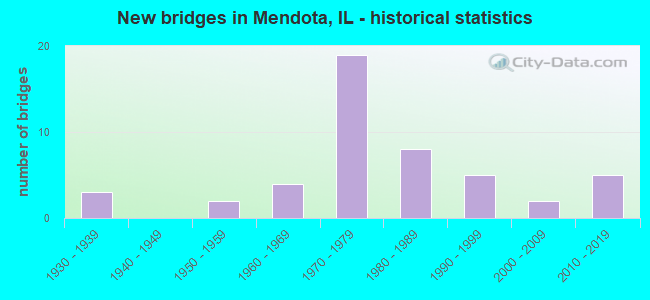
- New bridges - historical statistics
- 31930-1939
- 21950-1959
- 41960-1969
- 191970-1979
- 81980-1989
- 51990-1999
- 22000-2009
- 52010-2019


- Bridge Condition - Deck
- 18.4%Very good
- 55.3%Good
- 18.4%Satisfactory
- 2.6%Fair
- 5.3%Poor

- Bridge Condition - Superstructure
- 21.1%Very good
- 55.3%Good
- 15.8%Satisfactory
- 2.6%Fair
- 5.3%Poor

- Bridge Condition - Substructure
- 2.6%Excellent
- 31.6%Very good
- 15.8%Good
- 13.2%Satisfactory
- 31.6%Fair
- 2.6%Poor
- 2.6%Serious

- Bridge Condition - Channel
- 35.7%Very good
- 35.7%Good
- 23.8%Satisfactory
- 2.4%Fair
- 2.4%Poor

- Bridge Condition - Culverts
- 28.6%Very good
- 57.1%Good
- 14.3%Satisfactory
Find on map >> Show street view
Structure Number: 522019, Location: .1 MI W LASALLE CO (Lat: 41.594564, Lng: -89.168797), Route carried "on" structure: US 52, Year Built: 1993, Status: Open, Structure Length: 0.81m (2.66ft), Average Daily Traffic: 2,300 (year 2021), Truck Traffic: 44%, Average Future Daily Traffic: 2,900 (year 2040), Design Load: HS 20+Mod, Features Intersected: PIKE CREEK
Minimum Vertical Clearance: 30+ m (98+ ft), Kilometerpoint: 119.764, Lanes on structure: 2, Base Highway Network: Yes, Owner: State Highway Agency, Approaching Roadway Width: 7.9m (25.9ft), Material/Design: Concrete, Design/Construction: Culvert, Number Of Spans In Main Unit: 2, Length of Maximum Span: 3.9m (12.8ft), Curb-To-Curb Width: 11.0m (36.1ft), Out-to-Out Width: 12.2m (40.0ft)
Condition: Channel: Good, Culverts: Good, Operating Rating: 68.4 metric tons, Method Used To Determine Operating Rating: Load Factor (LF) rating reported by rating factor (RF) method using MS18 loading, Inventory Rating: 41.5 metric tons, Method Used To Determine Inventory Rating: Load Factor (LF) rating reported by rating factor (RF) method using MS18 loading, Structural Evaluation: Better than present minimum criteria, Deck Geometry: Somewhat better than minimum adequacy, Waterway Adequacy: Equal to present desirable criteria, Approach Roadway Alignment: Equal to present desirable criteria, Designated Inspection Frequency: Every 48 months, Inspection Date: Febuary 2018
Find on map >> Show street view
Structure Number: 52413, Location: 4 MI. S. OF COMPTON (Lat: 41.629433, Lng: -89.052044), Route carried "on" structure: County highway , Year Built: 1997, Status: Open, Structure Length: 1.36m (4.46ft), Average Daily Traffic: 75 (year 2017), Average Future Daily Traffic: 50 (year 2040), Design Load: HS 20, Features Intersected: TRIB 4-MILR GROVE CK, Facility Carried by Structure: HEDGE RD
Minimum Vertical Clearance: 30+ m (98+ ft), Kilometerpoint: 7.242, Lanes on structure: 2, Owner: Town or Township Highway Agency, Approaching Roadway Width: 8.5m (27.9ft), Material/Design: Prestressed concrete, Design/Construction: Box Beam or Girders - Multiple, Number Of Spans In Main Unit: 1, Length of Maximum Span: 12.8m (42.0ft), Curb-To-Curb Width: 8.5m (27.9ft), Out-to-Out Width: 8.5m (27.9ft)
Condition: Deck: Good, Superstructure: Good, Substructure: Very good, Channel: Poor, Operating Rating: 44.1 metric tons, Method Used To Determine Operating Rating: Assigned rating based on Load Factor Design (LFD) reported by rating factor (RF) using MS18 loading, Inventory Rating: 32.4 metric tons, Method Used To Determine Inventory Rating: Assigned rating based on Load Factor Design (LFD) reported by rating factor (RF) using MS18 loading, Structural Evaluation: Better than present minimum criteria, Deck Geometry: Better than present minimum criteria, Waterway Adequacy: Equal to present desirable criteria, Approach Roadway Alignment: Equal to present desirable criteria, Designated Inspection Frequency: Every 48 months, Inspection Date: January 2019, Deck Structure Type: Concrete Precast Panels
Find on map >> Show street view
Structure Number: 52459, Location: .2 MI. E. OF US 52 (Lat: 41.599867, Lng: -89.172242), Route carried "on" structure: County highway , Year Built: 1990, Status: Open, Structure Length: 0.97m (3.18ft), Average Daily Traffic: 500 (year 2016), Average Future Daily Traffic: 500 (year 2040), Design Load: HS 20, Features Intersected: BR. OF BUREAU CREEK, Facility Carried by Structure: CEDAR GROVE RD-TR2
Minimum Vertical Clearance: 30+ m (98+ ft), Kilometerpoint: 0.177, Lanes on structure: 2, Owner: Town or Township Highway Agency, Approaching Roadway Width: 11.0m (36.1ft), Skew: 1 degrees, Material/Design: Concrete, Design/Construction: Channel Beam, Number Of Spans In Main Unit: 1, Length of Maximum Span: 8.9m (29.2ft), Curb-To-Curb Width: 8.0m (26.2ft), Out-to-Out Width: 8.0m (26.2ft)
Condition: Deck: Good, Superstructure: Good, Substructure: Very good, Channel: Very good, Operating Rating: 44.4 metric tons, Method Used To Determine Operating Rating: Assigned rating based on Load Factor Design (LFD) reported by rating factor (RF) using MS18 loading, Inventory Rating: 32.4 metric tons, Method Used To Determine Inventory Rating: Assigned rating based on Load Factor Design (LFD) reported by rating factor (RF) using MS18 loading, Structural Evaluation: Better than present minimum criteria, Deck Geometry: Somewhat better than minimum adequacy, Waterway Adequacy: Equal to present desirable criteria, Approach Roadway Alignment: Equal to present desirable criteria, Designated Inspection Frequency: Every 48 months, Inspection Date: January 2022, Deck Structure Type: Concrete Precast Panels, Wearing Surface/Protective System: Wearing Surface: Bituminous, Membrane: Built-up
Find on map >> Show street view
Structure Number: 524715, Location: 5.5 MI SW OF PAW PAW (Lat: 41.627994, Lng: -89.047850), Route carried "on" structure: County highway , Year Built: 2014, Status: Open, Structure Length: 2.53m (8.30ft), Average Daily Traffic: 350 (year 2017), Truck Traffic: 1%, Average Future Daily Traffic: 226 (year 2032), Design Load: HS 25 or greater, Features Intersected: FOUR MI GROVE, Facility Carried by Structure: WELLAND RD
Minimum Vertical Clearance: 30+ m (98+ ft), Kilometerpoint: 0.354, Lanes on structure: 2, Owner: Town or Township Highway Agency, Approaching Roadway Width: 6.1m (20.0ft), Material/Design: Prestressed concrete, Design/Construction: Box Beam or Girders - Multiple, Number Of Spans In Main Unit: 3, Length of Maximum Span: 11.4m (37.4ft), Curb-To-Curb Width: 8.5m (27.9ft), Out-to-Out Width: 8.5m (27.9ft)
Condition: Deck: Good, Superstructure: Good, Substructure: Very good, Channel: Very good, Operating Rating: 42.1 metric tons, Method Used To Determine Operating Rating: Assigned ratings based on Load and Resistance Factor Design (LRFD) reported by rating factor (RF) using HL93 loadings, Inventory Rating: 32.4 metric tons, Method Used To Determine Inventory Rating: Assigned ratings based on Load and Resistance Factor Design (LRFD) reported by rating factor (RF) using HL93 loadings, Structural Evaluation: Better than present minimum criteria, Deck Geometry: Equal to present minimum criteria, Waterway Adequacy: Equal to present desirable criteria, Approach Roadway Alignment: Equal to present desirable criteria, Designated Inspection Frequency: Every 48 months, Inspection Date: October 2020, Deck Structure Type: Concrete Precast Panels
Find on map >> Show street view
Structure Number: 500162, Location: 3 MI N OF US 34 (Lat: 41.597839, Lng: -89.060850), Route carried "under" structure: Interstate 39, Year Built: 1977, Structure Length: 0. m, Average Daily Traffic: 20,200 (year 2019), Truck Traffic: 38%, Features Intersected: FAI 39, US 51, Facility Carried by Structure: FAS 269 (CH 12)
Minimum Vertical Clearance: 5.72m (18.77ft), Kilometerpoint: 121.904, Lanes on structure: 2, Lanes under structure: 4, Material/Design: Steel continuous, Design/Construction: Box Beam or Girders - Single/Spread, Length of Maximum Span: 33.8m (110.9ft)
Find on map >> Show street view
Structure Number: 500166, Location: 1 MI S OF US 34 (Lat: 41.539261, Lng: -89.059569), Route carried "under" structure: Interstate 39, Year Built: 1977, Structure Length: 0. m, Average Daily Traffic: 18,400 (year 2021), Truck Traffic: 22%, Features Intersected: I-39/US 51, Facility Carried by Structure: TR 105
Minimum Vertical Clearance: 4.95m (16.24ft), Kilometerpoint: 115.387, Lanes on structure: 2, Lanes under structure: 4, Material/Design: Steel continuous, Design/Construction: Box Beam or Girders - Single/Spread, Length of Maximum Span: 32.0m (105.0ft)
Find on map >> Show street view
Structure Number: 520059, Location: ON LEE-LASALLE CO (Lat: 41.626717, Lng: -89.061072), Route carried "under" structure: Interstate 39, Year Built: 1983, Structure Length: 0. m, Average Daily Traffic: 20,200 (year 2019), Truck Traffic: 38%, Features Intersected: I-39 & US 51, Facility Carried by Structure: WELLAND RD
Minimum Vertical Clearance: 5.18m (16.99ft), Kilometerpoint: 125.123, Lanes on structure: 2, Lanes under structure: 4, Material/Design: Steel continuous, Design/Construction: Stringer/Multi-beam, Length of Maximum Span: 32.2m (105.6ft)