Bridge Statistics for Manchester, Tennessee (TN)
Condition, Traffic, Stress, Structural Evaluation, Project Costs
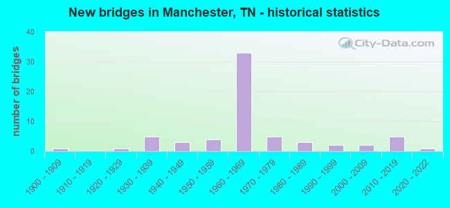
- New bridges - historical statistics
- 11900-1909
- 11920-1929
- 51930-1939
- 31940-1949
- 41950-1959
- 331960-1969
- 51970-1979
- 31980-1989
- 21990-1999
- 22000-2009
- 52010-2019
- 12020-2022

- Reconstructed bridges - Historical Statistics
- 11950-1959
- 31960-1969
- 01970-1979
- 21980-1989
- 11990-1999
- 12000-2009
- 12010-2019


- Bridge Condition - Deck
- 7.9%Very good
- 44.7%Good
- 26.3%Satisfactory
- 18.4%Fair
- 2.6%Poor

- Bridge Condition - Superstructure
- 5.3%Very good
- 39.5%Good
- 31.6%Satisfactory
- 18.4%Fair
- 2.6%Poor
- 2.6%Critical

- Bridge Condition - Substructure
- 5.3%Very good
- 47.4%Good
- 28.9%Satisfactory
- 18.4%Fair

- Bridge Condition - Channel
- 14.6%Very good
- 51.2%Good
- 22.0%Satisfactory
- 12.2%Fair

- Bridge Condition - Culverts
- 5.6%Very good
- 38.9%Good
- 38.9%Satisfactory
- 16.7%Fair
Find on map >> Show street view
Structure Number: 16I00240037, Location: 3.8 MI E OF SR55 JCT. (Lat: 35.441767, Lng: -86.041650), Route carried "on" structure: Interstate 24, Year Built: 1966, Status: Open, Structure Length: 0.80m (2.62ft), Average Daily Traffic: 37,968 (year 2020), Truck Traffic: 34%, Average Future Daily Traffic: 67,232 (year 2039), Design Load: HS 20, Features Intersected: BRANCH
Minimum Vertical Clearance: 30+ m (98+ ft), Kilometerpoint: 29.290, Lanes on structure: 2, Base Highway Network: Yes, Owner: State Highway Agency, Approaching Roadway Width: 11.6m (38.1ft), Skew: 13 degrees, Material/Design: Concrete continuous, Design/Construction: Culvert, Number Of Spans In Main Unit: 2, Length of Maximum Span: 3.0m (9.8ft)
Condition: Channel: Good, Culverts: Good, Operating Rating: 89.1 metric tons, Method Used To Determine Operating Rating: Load Factor (LF), Inventory Rating: 32.4 metric tons, Method Used To Determine Inventory Rating: Load Factor (LF), Structural Evaluation: Better than present minimum criteria, Waterway Adequacy: Better than present minimum criteria, Approach Roadway Alignment: Equal to present desirable criteria, Designated Inspection Frequency: Every 24 months, Inspection Date: October 2021
Find on map >> Show street view
Structure Number: 16I00240038, Location: 3.8 MI E OF SR55 JCT. (Lat: 35.441883, Lng: -86.040583), Route carried "on" structure: Interstate 24, Year Built: 1966, Status: Open, Structure Length: 0.80m (2.62ft), Average Daily Traffic: 37,968 (year 2020), Truck Traffic: 34%, Average Future Daily Traffic: 67,232 (year 2039), Design Load: HS 20, Features Intersected: BRANCH
Minimum Vertical Clearance: 30+ m (98+ ft), Kilometerpoint: 29.290, Lanes on structure: 2, Base Highway Network: Yes, Owner: State Highway Agency, Approaching Roadway Width: 11.6m (38.1ft), Skew: 13 degrees, Material/Design: Concrete continuous, Design/Construction: Culvert, Number Of Spans In Main Unit: 2, Length of Maximum Span: 3.0m (9.8ft)
Condition: Channel: Very good, Culverts: Very good, Operating Rating: 89.1 metric tons, Method Used To Determine Operating Rating: Load Factor (LF), Inventory Rating: 32.4 metric tons, Method Used To Determine Inventory Rating: Load Factor (LF), Structural Evaluation: Equal to present desirable criteria, Waterway Adequacy: Equal to present desirable criteria, Approach Roadway Alignment: Equal to present desirable criteria, Designated Inspection Frequency: Every 24 months, Inspection Date: October 2021
Find on map >> Show street view
Structure Number: 16I00240039, Location: AEDC EXIT (Lat: 35.417000, Lng: -86.016650), Route carried "on" structure: County highway 918, Year Built: 1963, Status: Open, Structure Length: 11.23m (36.84ft), Average Daily Traffic: 8,018 (year 2020), Truck Traffic: 3%, Average Future Daily Traffic: 14,752 (year 2040), Design Load: HS 20, Features Intersected: A.E.D.C. RD. / I24
Minimum Vertical Clearance: 30+ m (98+ ft), Kilometerpoint: 12.344, Lanes on structure: 2, Lanes under structure: 4, Owner: State Highway Agency, Approaching Roadway Width: 11.6m (38.1ft), Skew: 3 degrees, Material/Design: Steel continuous, Design/Construction: Stringer/Multi-beam, Number Of Spans In Main Unit: 5, Length of Maximum Span: 26.2m (86.0ft), Curb-To-Curb Width: 8.5m (27.9ft), Out-to-Out Width: 10.5m (34.4ft)
Condition: Deck: Fair, Superstructure: Satisfactory, Substructure: Satisfactory, Operating Rating: 44.1 metric tons, Method Used To Determine Operating Rating: Load and Resistance Factor Rating (LRFR) rating reported by rating factor(RF) method using HL-93 loadings, Inventory Rating: 34.3 metric tons, Method Used To Determine Inventory Rating: Load and Resistance Factor Rating (LRFR) rating reported by rating factor(RF) method using HL-93 loadings, Structural Evaluation: Equal to present minimum criteria, Deck Geometry: Meets minimum limits, Underclear: Somewhat better than minimum adequacy, Approach Roadway Alignment: Equal to present desirable criteria, Length Of Structure Improvement: 11.23m (36.84ft), Designated Inspection Frequency: Every 24 months, Inspection Date: October 2021, Bridge Improvement Cost: $2,488,000, Roadway Improvement Cost: $249,000, Total Project Cost: $3,733,000 ( Estimate for 2020), Deck Structure Type: Concrete Cast-file-Place, Wearing Surface/Protective System: Wearing Surface: Bituminous, Membrane: Preformed Fabric
Find on map >> Show street view
Structure Number: 16S42910007, Location: 1.37 MI FROM SR 2 (Lat: 35.498900, Lng: -86.143517), Route carried "on" structure: County highway 1113, Year Built: 1950, Status: Open, Structure Length: 1.95m (6.40ft), Average Daily Traffic: 2,475 (year 2020), Truck Traffic: 3%, Average Future Daily Traffic: 2,608 (year 2040), Design Load: H 15, Features Intersected: BREWER CREEK
Minimum Vertical Clearance: 30+ m (98+ ft), Kilometerpoint: 2.205, Lanes on structure: 2, Owner: County Highway Agency, Approaching Roadway Width: 6.7m (22.0ft), Material/Design: Concrete continuous, Design/Construction: Culvert, Number Of Spans In Main Unit: 4, Length of Maximum Span: 4.6m (15.1ft), Curb-To-Curb Width: 8.5m (27.9ft), Out-to-Out Width: 9.4m (30.8ft)
Condition: Channel: Satisfactory, Culverts: Satisfactory, Operating Rating: 73.8 metric tons, Method Used To Determine Operating Rating: Load Factor (LF), Inventory Rating: 24.3 metric tons, Method Used To Determine Inventory Rating: Load Factor (LF), Structural Evaluation: Equal to present minimum criteria, Deck Geometry: Meets minimum limits, Waterway Adequacy: Better than present minimum criteria, Approach Roadway Alignment: Equal to present minimum criteria, Length Of Structure Improvement: 1.95m (6.40ft), Designated Inspection Frequency: Every 24 months, Inspection Date: Febuary 2022, Bridge Improvement Cost: $104,000, Roadway Improvement Cost: $11,000, Total Project Cost: $157,000 ( Estimate for 2020)
Find on map >> Show street view
Structure Number: 16S44420003, Location: 1.9 MI FROM SR 2 (Lat: 35.512500, Lng: -86.151867), Route carried "on" structure: County highway 2116, Year Built: 1973, Status: Open, Structure Length: 0.79m (2.59ft), Average Daily Traffic: 628 (year 2020), Truck Traffic: 3%, Average Future Daily Traffic: 976 (year 2040), Design Load: H 15, Features Intersected: BREWER CREEK
Minimum Vertical Clearance: 30+ m (98+ ft), Kilometerpoint: 4.297, Lanes on structure: 2, Owner: County Highway Agency, Approaching Roadway Width: 8.2m (26.9ft), Material/Design: Concrete continuous, Design/Construction: Culvert, Number Of Spans In Main Unit: 2, Length of Maximum Span: 3.7m (12.1ft)
Condition: Channel: Satisfactory, Culverts: Good, Operating Rating: 89.1 metric tons, Method Used To Determine Operating Rating: Load Factor (LF), Inventory Rating: 32.4 metric tons, Method Used To Determine Inventory Rating: Load Factor (LF), Structural Evaluation: Better than present minimum criteria, Waterway Adequacy: Better than present minimum criteria, Approach Roadway Alignment: Equal to present desirable criteria, Designated Inspection Frequency: Every 24 months, Inspection Date: April 2020
Find on map >> Show street view
Structure Number: 16SR0020001, Location: NEAR BEECH GROVE (Lat: 35.626683, Lng: -86.239433), Route carried "on" structure: US 41, Year Built: 1935, Status: Posted for load, Structure Length: 5.24m (17.19ft), Average Daily Traffic: 3,590 (year 2020), Truck Traffic: 5%, Average Future Daily Traffic: 5,744 (year 2042), Design Load: H 15, Features Intersected: GARRISON FORK CREEK, Facility Carried by Structure: FAS 2
Minimum Vertical Clearance: 30+ m (98+ ft), Kilometerpoint: 0.821, Lanes on structure: 2, Owner: State Highway Agency, Approaching Roadway Width: 10.4m (34.1ft), Material/Design: Concrete, Design/Construction: Tee Beam, Number Of Spans In Main Unit: 4, Length of Maximum Span: 13.1m (43.0ft), Curb or Sidewalk Widths: Left: 1.5m (4.9ft), Right: 1.5m (4.9ft), Curb-To-Curb Width: 9.1m (29.9ft), Out-to-Out Width: 12.9m (42.3ft)
Condition: Deck: Satisfactory, Superstructure: Satisfactory, Substructure: Fair, Channel: Good, Operating Rating: 29.5 metric tons, Method Used To Determine Operating Rating: Load and Resistance Factor Rating (LRFR) rating reported by rating factor(RF) method using HL-93 loadings, Inventory Rating: 22.7 metric tons, Method Used To Determine Inventory Rating: Load and Resistance Factor Rating (LRFR) rating reported by rating factor(RF) method using HL-93 loadings, Structural Evaluation: Somewhat better than minimum adequacy, Deck Geometry: Meets minimum limits, Waterway Adequacy: Better than present minimum criteria, Approach Roadway Alignment: Equal to present desirable criteria, Length Of Structure Improvement: 5.24m (17.19ft), Designated Inspection Frequency: Every 24 months, Inspection Date: October 2021, Bridge Improvement Cost: $381,000, Roadway Improvement Cost: $39,000, Total Project Cost: $572,000 ( Estimate for 2022), Deck Structure Type: Concrete Cast-file-Place, Wearing Surface/Protective System: Wearing Surface: Bituminous
Find on map >> Show street view
Structure Number: 16SR0020011, Location: IN MANCHESTER CITY LIMITS (Lat: 35.495700, Lng: -86.104133), Route carried "on" structure: US 41, Year Built: 2012, Status: Open, Structure Length: 10.24m (33.60ft), Average Daily Traffic: 8,786 (year 2020), Truck Traffic: 4%, Average Future Daily Traffic: 15,456 (year 2040), Design Load: HL 93, Features Intersected: DUCK RIVER, Facility Carried by Structure: FAU 2
Minimum Vertical Clearance: 30+ m (98+ ft), Kilometerpoint: 20.455, Lanes on structure: 3, Owner: State Highway Agency, Approaching Roadway Width: 19.5m (64.0ft), Skew: 2 degrees, Material/Design: Steel continuous, Design/Construction: Stringer/Multi-beam, Number Of Spans In Main Unit: 2, Length of Maximum Span: 51.2m (168.0ft), Curb or Sidewalk Widths: Left: 0.0m, Right: 1.5m (4.9ft), Curb-To-Curb Width: 19.7m (64.6ft), Out-to-Out Width: 21.9m (71.9ft)
Condition: Deck: Very good, Superstructure: Very good, Substructure: Very good, Channel: Very good, Operating Rating: 44.1 metric tons, Method Used To Determine Operating Rating: Assigned ratings based on Load and Resistance Factor Design (LRFD) reported by rating factor (RF) using HL93 loadings, Inventory Rating: 32.4 metric tons, Method Used To Determine Inventory Rating: Assigned ratings based on Load and Resistance Factor Design (LRFD) reported by rating factor (RF) using HL93 loadings, Structural Evaluation: Equal to present desirable criteria, Deck Geometry: Superior to present desirable criteria, Waterway Adequacy: Equal to present desirable criteria, Approach Roadway Alignment: Equal to present desirable criteria, Designated Inspection Frequency: Every 24 months, Underwater Inspection Frequency: Every 60 months, Inspection Date: October 2021, Underwater Inspection Date: May 2017, Deck Structure Type: Concrete Cast-file-Place, Wearing Surface/Protective System: Wearing Surface: Monolithic Concrete, Membrane: Epoxy
Find on map >> Show street view
Structure Number: 16SR0020013, Location: IN MANCHESTER CITY LIMITS (Lat: 35.486733, Lng: -86.091400), Route carried "on" structure: US 41, Year Built: 1958, Status: Open, Structure Length: 9.72m (31.89ft), Average Daily Traffic: 10,856 (year 2020), Truck Traffic: 9%, Average Future Daily Traffic: 17,370 (year 2041), Design Load: HS 20, Features Intersected: LITTLE DUCK RIVER, Facility Carried by Structure: FAU 2
Minimum Vertical Clearance: 30+ m (98+ ft), Kilometerpoint: 22.016, Lanes on structure: 2, Base Highway Network: Yes, Owner: State Highway Agency, Approaching Roadway Width: 14.3m (46.9ft), Skew: 15 degrees, Material/Design: Concrete, Design/Construction: Tee Beam, Number Of Spans In Main Unit: 6, Length of Maximum Span: 16.8m (55.1ft), Curb or Sidewalk Widths: Left: 1.8m (5.9ft), Right: 0.0m, Curb-To-Curb Width: 8.5m (27.9ft), Out-to-Out Width: 11.7m (38.4ft)
Condition: Deck: Good, Superstructure: Good, Substructure: Good, Channel: Very good, Operating Rating: 81.0 metric tons, Method Used To Determine Operating Rating: Load Factor (LF), Inventory Rating: 32.4 metric tons, Method Used To Determine Inventory Rating: Load Factor (LF), Structural Evaluation: Better than present minimum criteria, Deck Geometry: Meets minimum limits, Waterway Adequacy: Equal to present desirable criteria, Approach Roadway Alignment: Equal to present minimum criteria, Designated Inspection Frequency: Every 24 months, Inspection Date: October 2021, Deck Structure Type: Concrete Cast-file-Place, Wearing Surface/Protective System: Wearing Surface: Bituminous
Find on map >> Show street view
Structure Number: 16SR0020014, Location: IN MANCHESTER CITY LIMITS (Lat: 35.486667, Lng: -86.091100), Route carried "on" structure: US 41, Year Built: 1934, Year Reconstructed: 1958, Status: Open, Structure Length: 9.72m (31.89ft), Average Daily Traffic: 10,856 (year 2020), Truck Traffic: 9%, Average Future Daily Traffic: 17,370 (year 2041), Design Load: HL 93, Features Intersected: LITTLE DUCK RIVER, Facility Carried by Structure: FAU 2
Minimum Vertical Clearance: 30+ m (98+ ft), Kilometerpoint: 22.016, Lanes on structure: 2, Base Highway Network: Yes, Owner: State Highway Agency, Approaching Roadway Width: 12.2m (40.0ft), Skew: 15 degrees, Material/Design: Concrete, Design/Construction: Tee Beam, Number Of Spans In Main Unit: 6, Length of Maximum Span: 16.8m (55.1ft), Curb or Sidewalk Widths: Left: 0.0m, Right: 1.8m (5.9ft), Curb-To-Curb Width: 8.5m (27.9ft), Out-to-Out Width: 11.7m (38.4ft)
Condition: Deck: Good, Superstructure: Good, Substructure: Good, Channel: Very good, Operating Rating: 54.9 metric tons, Method Used To Determine Operating Rating: Load Factor (LF), Inventory Rating: 32.4 metric tons, Method Used To Determine Inventory Rating: Load Factor (LF), Structural Evaluation: Better than present minimum criteria, Deck Geometry: Meets minimum limits, Waterway Adequacy: Equal to present desirable criteria, Approach Roadway Alignment: Equal to present minimum criteria, Designated Inspection Frequency: Every 24 months, Inspection Date: October 2021, Deck Structure Type: Concrete Cast-file-Place, Wearing Surface/Protective System: Wearing Surface: Bituminous
Find on map >> Show street view
Structure Number: 16SR0020015, Location: IN MANCHESTER CITY LIMITS (Lat: 35.480250, Lng: -86.085800), Route carried "on" structure: US 41, Year Built: 1928, Year Reconstructed: 1968, Status: Posted for load, Structure Length: 4.75m (15.58ft), Average Daily Traffic: 12,277 (year 2020), Truck Traffic: 9%, Average Future Daily Traffic: 19,643 (year 2041), Design Load: H 15, Features Intersected: CFW RAILROAD, Facility Carried by Structure: FAU 2 349448N
Minimum Vertical Clearance: 30+ m (98+ ft), Kilometerpoint: 22.982, Lanes on structure: 4, Base Highway Network: Yes, Owner: State Highway Agency, Approaching Roadway Width: 26.2m (86.0ft), Skew: 23 degrees, Material/Design: Concrete, Design/Construction: Tee Beam, Number Of Spans In Main Unit: 4, Length of Maximum Span: 11.9m (39.0ft), Curb or Sidewalk Widths: Left: 1.8m (5.9ft), Right: 1.8m (5.9ft), Curb-To-Curb Width: 21.3m (69.9ft), Out-to-Out Width: 25.8m (84.6ft)
Condition: Deck: Fair, Superstructure: Satisfactory, Substructure: Satisfactory, Operating Rating: 32.4 metric tons, Method Used To Determine Operating Rating: Load and Resistance Factor Rating (LRFR) rating reported by rating factor(RF) method using HL-93 loadings, Inventory Rating: 25.3 metric tons, Method Used To Determine Inventory Rating: Load and Resistance Factor Rating (LRFR) rating reported by rating factor(RF) method using HL-93 loadings, Structural Evaluation: Equal to present minimum criteria, Deck Geometry: Superior to present desirable criteria, Underclear: Meets minimum limits, Approach Roadway Alignment: Equal to present desirable criteria, Length Of Structure Improvement: 4.75m (15.58ft), Designated Inspection Frequency: Every 24 months, Inspection Date: October 2021, Bridge Improvement Cost: $1,705,000, Roadway Improvement Cost: $171,000, Total Project Cost: $2,558,000 ( Estimate for 2021), Deck Structure Type: Concrete Cast-file-Place, Wearing Surface/Protective System: Wearing Surface: Bituminous
Find on map >> Show street view
Structure Number: 16SR0020017, Location: IN MANCHESTER (Lat: 35.462367, Lng: -86.065050), Route carried "on" structure: US 41, Year Built: 1950, Year Reconstructed: 1997, Status: Posted for load, Structure Length: 3.47m (11.38ft), Average Daily Traffic: 18,003 (year 2020), Truck Traffic: 7%, Average Future Daily Traffic: 28,805 (year 2042), Design Load: HS 20, Features Intersected: LITTLE DUCK RIVER, Facility Carried by Structure: FAU 2
Minimum Vertical Clearance: 30+ m (98+ ft), Kilometerpoint: 25.717, Lanes on structure: 5, Base Highway Network: Yes, Owner: State Highway Agency, Approaching Roadway Width: 25.6m (84.0ft), Skew: 1 degrees, Material/Design: Concrete, Design/Construction: Stringer/Multi-beam, Number Of Spans In Main Unit: 4, Length of Maximum Span: 8.8m (28.9ft), Curb or Sidewalk Widths: Left: 1.5m (4.9ft), Right: 1.5m (4.9ft), Curb-To-Curb Width: 25.6m (84.0ft), Out-to-Out Width: 29.3m (96.1ft)
Condition: Deck: Good, Superstructure: Good, Substructure: Good, Channel: Good, Operating Rating: 33.7 metric tons, Method Used To Determine Operating Rating: Load and Resistance Factor Rating (LRFR) rating reported by rating factor(RF) method using HL-93 loadings, Inventory Rating: 24.3 metric tons, Method Used To Determine Inventory Rating: Load and Resistance Factor Rating (LRFR) rating reported by rating factor(RF) method using HL-93 loadings, Structural Evaluation: Equal to present minimum criteria, Deck Geometry: Superior to present desirable criteria, Waterway Adequacy: Better than present minimum criteria, Approach Roadway Alignment: Equal to present desirable criteria, Length Of Structure Improvement: 3.47m (11.38ft), Designated Inspection Frequency: Every 24 months, Inspection Date: October 2021, Bridge Improvement Cost: $1,000, Roadway Improvement Cost: $1,000, Total Project Cost: $2,000 ( Estimate for 2022), Deck Structure Type: Concrete Cast-file-Place, Wearing Surface/Protective System: Wearing Surface: Monolithic Concrete, Deck Protection: Epoxy Coated Reinforcing
Find on map >> Show street view
Structure Number: 16SR0550013, Location: IN MANCHESTER (Lat: 35.479533, Lng: -86.079783), Route carried "on" structure: State highway 55, Year Built: 1941, Status: Posted for load, Structure Length: 11.73m (38.48ft), Average Daily Traffic: 15,945 (year 2020), Truck Traffic: 9%, Average Future Daily Traffic: 25,512 (year 2042), Design Load: H 15, Features Intersected: LITTLE DUCK RIVER
Minimum Vertical Clearance: 30+ m (98+ ft), Kilometerpoint: 22.579, Lanes on structure: 4, Base Highway Network: Yes (Inventory Route: 16SR0550, Subroute: 1), Owner: State Highway Agency, Approaching Roadway Width: 17.7m (58.1ft), Material/Design: Concrete, Design/Construction: Tee Beam, Number Of Spans In Main Unit: 8, Length of Maximum Span: 16.2m (53.1ft), Curb or Sidewalk Widths: Left: 1.5m (4.9ft), Right: 1.5m (4.9ft), Curb-To-Curb Width: 14.6m (47.9ft), Out-to-Out Width: 18.4m (60.4ft)
Condition: Deck: Fair, Superstructure: Fair, Substructure: Fair, Channel: Good, Operating Rating: 29.5 metric tons, Method Used To Determine Operating Rating: Load and Resistance Factor Rating (LRFR) rating reported by rating factor(RF) method using HL-93 loadings, Inventory Rating: 23.0 metric tons, Method Used To Determine Inventory Rating: Load and Resistance Factor Rating (LRFR) rating reported by rating factor(RF) method using HL-93 loadings, Structural Evaluation: Somewhat better than minimum adequacy, Deck Geometry: High priority of replacement, Waterway Adequacy: Better than present minimum criteria, Approach Roadway Alignment: Equal to present minimum criteria, Length Of Structure Improvement: 11.73m (38.48ft), Designated Inspection Frequency: Every 24 months, Inspection Date: November 2021, Bridge Improvement Cost: $981,000, Roadway Improvement Cost: $99,000, Total Project Cost: $1,472,000 ( Estimate for 2022), Deck Structure Type: Concrete Cast-file-Place, Wearing Surface/Protective System: Wearing Surface: Bituminous
Find on map >> Show street view
Structure Number: 16SR0550023, Location: 3.7 MI NE OF I24 (Lat: 35.522733, Lng: -86.022950), Route carried "on" structure: US 55, Year Built: 1986, Status: Open, Structure Length: 1.01m (3.31ft), Average Daily Traffic: 10,515 (year 2020), Truck Traffic: 11%, Average Future Daily Traffic: 17,872 (year 2039), Design Load: HS 20, Features Intersected: TAYLOR CREEK
Minimum Vertical Clearance: 30+ m (98+ ft), Kilometerpoint: 29.773, Lanes on structure: 5, Base Highway Network: Yes (Inventory Route: 16SR0550, Subroute: 1), Owner: State Highway Agency, Approaching Roadway Width: 20.7m (67.9ft), Skew: 1 degrees, Material/Design: Concrete continuous, Design/Construction: Culvert, Number Of Spans In Main Unit: 2, Length of Maximum Span: 4.6m (15.1ft), Curb-To-Curb Width: 25.6m (84.0ft), Out-to-Out Width: 32.1m (105.3ft)
Condition: Channel: Good, Culverts: Good, Operating Rating: 44.1 metric tons, Method Used To Determine Operating Rating: Load Factor (LF), Inventory Rating: 32.4 metric tons, Method Used To Determine Inventory Rating: Load Factor (LF), Structural Evaluation: Better than present minimum criteria, Deck Geometry: Superior to present desirable criteria, Waterway Adequacy: Better than present minimum criteria, Approach Roadway Alignment: Equal to present desirable criteria, Designated Inspection Frequency: Every 24 months, Inspection Date: November 2021
Find on map >> Show street view
Structure Number: 17008500009, Location: 3.4 MI E OF GADSDEN (Lat: 35.780778, Lng: -88.938583), Route carried "on" structure: County highway 850, Year Built: 2012, Status: Open, Structure Length: 1.33m (4.36ft), Average Daily Traffic: 270 (year 2020), Truck Traffic: 3%, Average Future Daily Traffic: 320 (year 2038), Design Load: HL 93, Features Intersected: BRANCH
Minimum Vertical Clearance: 30+ m (98+ ft), Kilometerpoint: 5.456, Lanes on structure: 2, Owner: County Highway Agency, Approaching Roadway Width: 7.9m (25.9ft), Skew: 3 degrees, Material/Design: Concrete continuous, Design/Construction: Culvert, Number Of Spans In Main Unit: 2, Length of Maximum Span: 6.6m (21.7ft), Curb-To-Curb Width: 8.5m (27.9ft), Out-to-Out Width: 10.4m (34.1ft)
Condition: Channel: Satisfactory, Culverts: Satisfactory, Operating Rating: 42.1 metric tons, Method Used To Determine Operating Rating: Load and Resistance Factor Rating (LRFR) rating reported by rating factor(RF) method using HL-93 loadings, Inventory Rating: 32.4 metric tons, Method Used To Determine Inventory Rating: Load and Resistance Factor Rating (LRFR) rating reported by rating factor(RF) method using HL-93 loadings, Structural Evaluation: Equal to present minimum criteria, Deck Geometry: Equal to present minimum criteria, Waterway Adequacy: Equal to present minimum criteria, Approach Roadway Alignment: Equal to present desirable criteria, Designated Inspection Frequency: Every 24 months, Inspection Date: April 2020, Deck Structure Type: Concrete Cast-file-Place, Wearing Surface/Protective System: Deck Protection: Epoxy Coated Reinforcing
Find on map >> Show street view
Structure Number: AFTNANZY00002, Location: 335 FEET NORTH OF S. FOUR (Lat: 35.379486, Lng: -86.047239), Route carried "on" structure: Alternate Federal lands road , Year Built: 1960, Status: Open, Structure Length: 3.11m (10.20ft), Average Daily Traffic: 10 (year 2020), Average Future Daily Traffic: 12 (year 2040), Features Intersected: EQUIPMENT, Facility Carried by Structure: ETF BRIDGE
Minimum Vertical Clearance: 30+ m (98+ ft), Kilometerpoint: 0.000, Lanes on structure: 2, Owner: Air Force, Approaching Roadway Width: 9.1m (29.9ft), Material/Design: Concrete, Design/Construction: Tee Beam, Number Of Spans In Main Unit: 5, Length of Maximum Span: 6.7m (22.0ft), Curb-To-Curb Width: 9.2m (30.2ft), Out-to-Out Width: 10.0m (32.8ft)
Condition: Deck: Satisfactory, Superstructure: Satisfactory, Substructure: Fair, Operating Rating: 32.7 metric tons, Method Used To Determine Operating Rating: Field evaluation and documented engineering judgment, Inventory Rating: 19.1 metric tons, Method Used To Determine Inventory Rating: Field evaluation and documented engineering judgment, Structural Evaluation: Somewhat better than minimum adequacy, Deck Geometry: Better than present minimum criteria, Approach Roadway Alignment: Equal to present desirable criteria, Designated Inspection Frequency: Every 24 months, Inspection Date: November 2020, Bridge Improvement Cost: $45,000, Roadway Improvement Cost: $5,000, Total Project Cost: $68,000 ( Estimate for 2018), Deck Structure Type: Concrete Cast-file-Place, Wearing Surface/Protective System: Wearing Surface: Monolithic Concrete
Find on map >> Show street view
Structure Number: AFTNANZY00003, Location: 596 FEET SOUTH OF VON KAR (Lat: 35.384072, Lng: -86.043500), Route carried "on" structure: Alternate Federal lands road , Year Built: 1960, Status: Posted for load, Structure Length: 1.08m (3.54ft), Average Daily Traffic: 50 (year 2020), Average Future Daily Traffic: 60 (year 2040), Features Intersected: HYPERBALLISTICS RANGE, Facility Carried by Structure: SECOND STREET
Minimum Vertical Clearance: 30+ m (98+ ft), Kilometerpoint: 0.000, Lanes on structure: 2, Owner: Air Force, Approaching Roadway Width: 8.1m (26.6ft), Material/Design: Concrete, Design/Construction: Frame, Number Of Spans In Main Unit: 2, Length of Maximum Span: 6.1m (20.0ft), Curb-To-Curb Width: 8.2m (26.9ft), Out-to-Out Width: 8.2m (26.9ft)
Condition: Deck: Good, Superstructure: Good, Substructure: Good, Operating Rating: 29.9 metric tons, Method Used To Determine Operating Rating: Load Factor (LF), Inventory Rating: 17.2 metric tons, Method Used To Determine Inventory Rating: Load Factor (LF), Structural Evaluation: Somewhat better than minimum adequacy, Deck Geometry: Equal to present minimum criteria, Approach Roadway Alignment: Equal to present desirable criteria, Designated Inspection Frequency: Every 24 months, Inspection Date: November 2020, Bridge Improvement Cost: $25,000, Roadway Improvement Cost: $3,000, Total Project Cost: $38,000 ( Estimate for 2018), Deck Structure Type: Concrete Cast-file-Place
Find on map >> Show street view
Structure Number: AFTNANZY00004, Location: 0.7 MILES WEST OF BASE EN (Lat: 35.385669, Lng: -86.043000), Route carried "on" structure: Alternate Federal lands road , Year Built: 1960, Status: Posted for load, Structure Length: 0.61m (2.00ft), Average Daily Traffic: 150 (year 2020), Average Future Daily Traffic: 180 (year 2040), Features Intersected: HYPERBALLISTICS RANGE, Facility Carried by Structure: VON KARMAN ROAD
Minimum Vertical Clearance: 30+ m (98+ ft), Kilometerpoint: 0.000, Lanes on structure: 2, Owner: Air Force, Approaching Roadway Width: 15.4m (50.5ft), Material/Design: Concrete, Design/Construction: Frame, Number Of Spans In Main Unit: 1, Length of Maximum Span: 6.1m (20.0ft), Curb-To-Curb Width: 15.5m (50.9ft), Out-to-Out Width: 15.5m (50.9ft)
Condition: Deck: Satisfactory, Superstructure: Satisfactory, Substructure: Satisfactory, Operating Rating: 29.9 metric tons, Method Used To Determine Operating Rating: Load Factor (LF), Inventory Rating: 17.2 metric tons, Method Used To Determine Inventory Rating: Load Factor (LF), Structural Evaluation: Somewhat better than minimum adequacy, Deck Geometry: Superior to present desirable criteria, Approach Roadway Alignment: Equal to present desirable criteria, Designated Inspection Frequency: Every 24 months, Inspection Date: November 2020, Bridge Improvement Cost: $45,000, Roadway Improvement Cost: $5,000, Total Project Cost: $68,000 ( Estimate for 2018), Deck Structure Type: Concrete Cast-file-Place
Find on map >> Show street view
Structure Number: 16I00240019, Location: 1.2 MI. W OF SR-53 JCT. (Lat: 35.508000, Lng: -86.104233), Route carried "under" structure: Interstate 24, Year Built: 1966, Structure Length: 0. m, Average Daily Traffic: 41,354 (year 2020), Truck Traffic: 33%, Features Intersected: NFA A886, Facility Carried by Structure: NFA A886 (SA 1616)
Minimum Vertical Clearance: 5.69m (18.67ft), Kilometerpoint: 19.666, Lanes on structure: 2, Lanes under structure: 4, Material/Design: Concrete continuous, Design/Construction: Tee Beam, Length of Maximum Span: 25.9m (85.0ft)
Find on map >> Show street view
Structure Number: 16I00240023, Location: IN MANCHESTER (Lat: 35.499300, Lng: -86.086583), Route carried "under" structure: Interstate 24, Year Built: 2010, Structure Length: 0. m, Average Daily Traffic: 41,354 (year 2020), Truck Traffic: 33%, Features Intersected: SR 53, Facility Carried by Structure: FAP 53
Minimum Vertical Clearance: 5.28m (17.32ft), Kilometerpoint: 21.541, Lanes on structure: 5, Lanes under structure: 4, Material/Design: Concrete continuous, Design/Construction: Tee Beam, Length of Maximum Span: 41.1m (134.8ft)
Find on map >> Show street view
Structure Number: 16I00240027, Location: .1 MI OF SR55 (Lat: 35.493750, Lng: -86.077333), Route carried "under" structure: County highway 92, Year Built: 1966, Structure Length: 0. m, Average Daily Traffic: 1,960 (year 2022), Truck Traffic: 2%, Features Intersected: I24 EBL, Facility Carried by Structure: I24
Minimum Vertical Clearance: 4.09m (13.42ft), Kilometerpoint: 1.553, Lanes on structure: 2, Lanes under structure: 2, Material/Design: Prestressed concrete continuous, Design/Construction: Stringer/Multi-beam, Length of Maximum Span: 23.4m (76.8ft)
Find on map >> Show street view
Structure Number: 16I00240028, Location: .1 MI OF SR55 (Lat: 35.493900, Lng: -86.077050), Route carried "under" structure: County highway 92, Year Built: 1966, Structure Length: 0. m, Average Daily Traffic: 1,960 (year 2022), Truck Traffic: 2%, Features Intersected: I24 WBL, Facility Carried by Structure: I24 WBL
Minimum Vertical Clearance: 4.14m (13.58ft), Kilometerpoint: 1.529, Lanes on structure: 3, Lanes under structure: 2, Material/Design: Prestressed concrete continuous, Design/Construction: Stringer/Multi-beam, Length of Maximum Span: 23.4m (76.8ft)
Find on map >> Show street view
Structure Number: 16I00240029, Location: SR55/I-24 IN MANCHESTER (Lat: 35.489433, Lng: -86.074050), Route carried "under" structure: Interstate 24, Year Built: 1973, Structure Length: 0. m, Average Daily Traffic: 42,735 (year 2020), Truck Traffic: 34%, Features Intersected: SR 55 NBL, Facility Carried by Structure: FAP 55
Minimum Vertical Clearance: 5.89m (19.32ft), Kilometerpoint: 23.175, Lanes on structure: 2, Lanes under structure: 4, Material/Design: Concrete continuous, Design/Construction: Frame, Length of Maximum Span: 24.1m (79.1ft)
Find on map >> Show street view
Structure Number: 16I0024003, Location: SR55/I-24 IN MANCHESTER (Lat: 35.489667, Lng: -86.074233), Route carried "under" structure: Interstate 24, Year Built: 1966, Structure Length: 0. m, Average Daily Traffic: 43,473 (year 2020), Truck Traffic: 32%, Features Intersected: SR 55 SBL, Facility Carried by Structure: FAP 55
Minimum Vertical Clearance: 5.84m (19.16ft), Kilometerpoint: 23.142, Lanes on structure: 2, Lanes under structure: 4, Material/Design: Concrete continuous, Design/Construction: Tee Beam, Length of Maximum Span: 24.1m (79.1ft)
Find on map >> Show street view
Structure Number: 16I00240033, Location: 1.1 MI E OF SR-55 JCT. (Lat: 35.476200, Lng: -86.063400), Route carried "under" structure: Interstate 24, Year Built: 1966, Structure Length: 0. m, Average Daily Traffic: 42,735 (year 2020), Truck Traffic: 34%, Features Intersected: NFA A152, Facility Carried by Structure: NFA A152
Minimum Vertical Clearance: 5.99m (19.65ft), Kilometerpoint: 24.945, Lanes on structure: 2, Lanes under structure: 4, Material/Design: Concrete continuous, Design/Construction: Tee Beam, Length of Maximum Span: 21.1m (69.2ft)
Find on map >> Show street view
Structure Number: 16I00240035, Location: 2.5 MI FROM SR 55 (Lat: 35.457800, Lng: -86.052233), Route carried "under" structure: Interstate 24, Year Built: 2000, Structure Length: 0. m, Average Daily Traffic: 42,735 (year 2020), Truck Traffic: 34%, Features Intersected: SR 2, Facility Carried by Structure: FAU 2
Minimum Vertical Clearance: 5.38m (17.65ft), Kilometerpoint: 27.246, Lanes on structure: 5, Lanes under structure: 4, Material/Design: Prestressed concrete continuous, Design/Construction: Stringer/Multi-beam, Length of Maximum Span: 41.4m (135.8ft)
Find on map >> Show street view
Structure Number: 16I00240039, Location: AEDC EXIT (Lat: 35.417000, Lng: -86.016650), Route carried "under" structure: Interstate 24, Year Built: 1963, Structure Length: 0. m, Average Daily Traffic: 35,234 (year 2020), Truck Traffic: 34%, Features Intersected: A.E.D.C. RD. / I2NFA 918, Facility Carried by Structure: NFA 918
Minimum Vertical Clearance: 4.90m (16.08ft), Kilometerpoint: 32.831, Lanes on structure: 2, Lanes under structure: 4, Material/Design: Steel continuous, Design/Construction: Stringer/Multi-beam, Length of Maximum Span: 26.2m (86.0ft)