Bridge Statistics for Lockport, Illinois (IL)
Condition, Traffic, Stress, Structural Evaluation, Project Costs
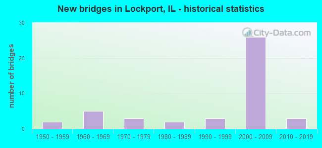
- New bridges - historical statistics
- 21950-1959
- 51960-1969
- 31970-1979
- 21980-1989
- 31990-1999
- 262000-2009
- 32010-2019

- Reconstructed bridges - Historical Statistics
- 11990-1999
- 02000-2009
- 02010-2019
- 12020-2022


- Bridge Condition - Deck
- 17.9%Very good
- 39.3%Good
- 21.4%Satisfactory
- 7.1%Fair
- 7.1%Poor
- 3.6%Serious
- 3.6%Critical

- Bridge Condition - Superstructure
- 36.4%Very good
- 33.3%Good
- 15.2%Satisfactory
- 9.1%Poor
- 3.0%Serious
- 3.0%Critical

- Bridge Condition - Substructure
- 36.4%Very good
- 48.5%Good
- 9.1%Satisfactory
- 6.1%Fair

- Bridge Condition - Channel
- 6.9%Excellent
- 44.8%Very good
- 24.1%Good
- 20.7%Satisfactory
- 3.4%Poor

- Bridge Condition - Culverts
- 20.0%Very good
- 60.0%Good
- 20.0%Fair
Find on map >> Show street view
Structure Number: 162626, Location: .4M N OF 135TH (Lat: 41.641897, Lng: -88.013008), Route carried "on" structure: Interstate 355, Year Built: 2007, Status: Open, Structure Length: 15.74m (51.64ft), Average Daily Traffic: 32,950 (year 2020), Truck Traffic: 25%, Average Future Daily Traffic: 31,467 (year 2032), Design Load: HS 20, Features Intersected: LONG RUN CREEK
Minimum Vertical Clearance: 30+ m (98+ ft), Kilometerpoint: 12.890, Lanes on structure: 3, Base Highway Network: Yes, Toll: On toll road, Owner: State Toll Authority, Approaching Roadway Width: 23.6m (77.4ft), Material/Design: Prestressed concrete continuous, Design/Construction: Stringer/Multi-beam, Number Of Spans In Main Unit: 5, Length of Maximum Span: 39.6m (129.9ft), Curb-To-Curb Width: 23.6m (77.4ft), Out-to-Out Width: 24.5m (80.4ft)
Condition: Deck: Good, Superstructure: Very good, Substructure: Good, Channel: Poor, Operating Rating: 70.3 metric tons, Method Used To Determine Operating Rating: Load Factor (LF) rating reported by rating factor (RF) method using MS18 loading, Inventory Rating: 42.1 metric tons, Method Used To Determine Inventory Rating: Load Factor (LF) rating reported by rating factor (RF) method using MS18 loading, Structural Evaluation: Better than present minimum criteria, Deck Geometry: Superior to present desirable criteria, Waterway Adequacy: Superior to present desirable criteria, Approach Roadway Alignment: Equal to present desirable criteria, Designated Inspection Frequency: Every 24 months, Inspection Date: April 2020, Deck Structure Type: Concrete Cast-file-Place
Find on map >> Show street view
Structure Number: 162627, Location: .4M N OF 135TH (Lat: 41.642019, Lng: -88.013028), Route carried "on" structure: Interstate 355, Year Built: 2007, Status: Open, Structure Length: 15.74m (51.64ft), Average Daily Traffic: 32,950 (year 2020), Truck Traffic: 25%, Average Future Daily Traffic: 31,467 (year 2032), Design Load: HS 20, Features Intersected: LONG RUN CREEK
Minimum Vertical Clearance: 30+ m (98+ ft), Kilometerpoint: 12.907, Lanes on structure: 3, Base Highway Network: Yes, Toll: On toll road, Owner: State Toll Authority, Approaching Roadway Width: 19.3m (63.3ft), Material/Design: Prestressed concrete continuous, Design/Construction: Stringer/Multi-beam, Number Of Spans In Main Unit: 5, Length of Maximum Span: 39.6m (129.9ft), Curb-To-Curb Width: 19.3m (63.3ft), Out-to-Out Width: 20.2m (66.3ft)
Condition: Deck: Satisfactory, Superstructure: Good, Substructure: Good, Channel: Excellent, Operating Rating: 70.3 metric tons, Method Used To Determine Operating Rating: Load Factor (LF) rating reported by rating factor (RF) method using MS18 loading, Inventory Rating: 42.1 metric tons, Method Used To Determine Inventory Rating: Load Factor (LF) rating reported by rating factor (RF) method using MS18 loading, Structural Evaluation: Better than present minimum criteria, Deck Geometry: Superior to present desirable criteria, Waterway Adequacy: Superior to present desirable criteria, Approach Roadway Alignment: Equal to present desirable criteria, Designated Inspection Frequency: Every 24 months, Inspection Date: April 2020, Deck Structure Type: Concrete Cast-file-Place
Find on map >> Show street view
Structure Number: 990135, Location: .36M E OF ILL 53 (Lat: 41.592581, Lng: -88.069567), Route carried "on" structure: Other road , Year Built: 1957, Year Reconstructed: 2020, Status: Open, Structure Length: 18.38m (60.30ft), Average Daily Traffic: 675 (year 2019), Truck Traffic: 56%, Average Future Daily Traffic: 503 (year 2032), Design Load: HS 20, Features Intersected: DESPLAINES RIV, Facility Carried by Structure: ILL 7 FRNT. RD
Minimum Vertical Clearance: 30+ m (98+ ft), Kilometerpoint: 0.692, Lanes on structure: 2, Owner: City or Municipal Highway Agency, Approaching Roadway Width: 13.4m (44.0ft), Material/Design: Steel continuous, Design/Construction: Stringer/Multi-beam, Number Of Spans In Main Unit: 8, Length of Maximum Span: 29.9m (98.1ft), Curb or Sidewalk Widths: Left: 0.6m (2.0ft), Right: 0.6m (2.0ft), Curb-To-Curb Width: 9.1m (29.9ft), Out-to-Out Width: 11.0m (36.1ft)
Condition: Deck: Good, Superstructure: Very good, Substructure: Good, Channel: Very good, Operating Rating: 52.5 metric tons, Method Used To Determine Operating Rating: Load Factor (LF) rating reported by rating factor (RF) method using MS18 loading, Inventory Rating: 31.4 metric tons, Method Used To Determine Inventory Rating: Load Factor (LF) rating reported by rating factor (RF) method using MS18 loading, Structural Evaluation: Better than present minimum criteria, Deck Geometry: Equal to present minimum criteria, Waterway Adequacy: Equal to present desirable criteria, Approach Roadway Alignment: Equal to present desirable criteria, Designated Inspection Frequency: Every 24 months, Inspection Date: October 2020, Deck Structure Type: Concrete Cast-file-Place, Wearing Surface/Protective System: Wearing Surface: Latex Concrete
Find on map >> Show street view
Structure Number: 990137, Location: 0.2 M W OF IL 171 (Lat: 41.589786, Lng: -88.059008), Route carried "on" structure: State highway 7, Year Built: 1951, Year Reconstructed: 2002, Status: Open, Structure Length: 4.01m (13.16ft), Average Daily Traffic: 20,800 (year 2021), Truck Traffic: 7%, Average Future Daily Traffic: 25,077 (year 2032), Design Load: HS 20, Features Intersected: I & M CANAL
Minimum Vertical Clearance: 30+ m (98+ ft), Kilometerpoint: 15.401, Lanes on structure: 2, Base Highway Network: Yes, Owner: State Highway Agency, Approaching Roadway Width: 11.0m (36.1ft), Material/Design: Steel continuous, Design/Construction: Stringer/Multi-beam, Number Of Spans In Main Unit: 3, Length of Maximum Span: 15.8m (51.8ft), Curb or Sidewalk Widths: Left: 2.1m (6.9ft), Right: 2.1m (6.9ft), Curb-To-Curb Width: 11.0m (36.1ft), Out-to-Out Width: 15.9m (52.2ft)
Condition: Deck: Good, Superstructure: Good, Substructure: Good, Channel: Good, Operating Rating: 88.8 metric tons, Method Used To Determine Operating Rating: Load Factor (LF) rating reported by rating factor (RF) method using MS18 loading, Inventory Rating: 53.5 metric tons, Method Used To Determine Inventory Rating: Load Factor (LF) rating reported by rating factor (RF) method using MS18 loading, Structural Evaluation: Better than present minimum criteria, Deck Geometry: Meets minimum limits, Waterway Adequacy: Equal to present desirable criteria, Approach Roadway Alignment: Equal to present desirable criteria, Length Of Structure Improvement: 4.79m (15.72ft), Designated Inspection Frequency: Every 48 months, Inspection Date: April 2021, Bridge Improvement Cost: $655,000, Roadway Improvement Cost: $66,000, Total Project Cost: $983,000, Deck Structure Type: Concrete Cast-file-Place, Wearing Surface/Protective System: Deck Protection: Epoxy Coated Reinforcing
Find on map >> Show street view
Structure Number: 990185, Location: 0.5 M W OF IL 171 (Lat: 41.592794, Lng: -88.071025), Route carried "on" structure: State highway 7, Year Built: 1971, Status: Open, Structure Length: 96.71m (317.29ft), Average Daily Traffic: 20,800 (year 2021), Truck Traffic: 7%, Average Future Daily Traffic: 25,077 (year 2032), Design Load: HS 20, Features Intersected: S&S CANAL/DES PLNS R
Minimum Vertical Clearance: 30+ m (98+ ft), Kilometerpoint: 14.323, Lanes on structure: 2, Base Highway Network: Yes, Owner: State Highway Agency, Approaching Roadway Width: 13.4m (44.0ft), Navigation Control: Yes ( Vertical Clearance: 14.3m (46.9ft), Horizontal Clearance: 80.8m (265.1ft)), Material/Design: Steel continuous, Design/Construction: Stringer/Multi-beam, Number Of Spans In Main Unit: 25, Length of Maximum Span: 80.8m (265.1ft), Curb-To-Curb Width: 13.0m (42.7ft), Out-to-Out Width: 14.0m (45.9ft)
Condition: Deck: Fair, Superstructure: Poor, Substructure: Fair, Channel: Good, Operating Rating: 25.6 metric tons, Method Used To Determine Operating Rating: Load and Resistance Factor Rating (LRFR) rating reported by rating factor(RF) method using HL-93 loadings, Inventory Rating: 19.8 metric tons, Method Used To Determine Inventory Rating: Load and Resistance Factor Rating (LRFR) rating reported by rating factor(RF) method using HL-93 loadings, Structural Evaluation: Meets minimum limits, Deck Geometry: Somewhat better than minimum adequacy, Waterway Adequacy: Superior to present desirable criteria, Approach Roadway Alignment: Equal to present desirable criteria, Designated Inspection Frequency: Every 12 months, Underwater Inspection Frequency: Every 60 months, Other Special Inspection Frequency: Every 48 months, Inspection Date: April 2021, Underwater Inspection Date: September 2019, Other Special Inspection Date: April 2021, Deck Structure Type: Concrete Cast-file-Place, Wearing Surface/Protective System: Wearing Surface: Latex Concrete
Find on map >> Show street view
Structure Number: 990273, Location: 0.7 M E OF IL 171 (Lat: 41.589000, Lng: -88.045706), Route carried "on" structure: State highway 7, Year Built: 1988, Status: Open, Structure Length: 0.88m (2.89ft), Average Daily Traffic: 14,600 (year 2021), Truck Traffic: 11%, Average Future Daily Traffic: 21,992 (year 2032), Design Load: HS 20, Features Intersected: MILNE CREEK
Minimum Vertical Clearance: 30+ m (98+ ft), Kilometerpoint: 16.640, Lanes on structure: 3, Base Highway Network: Yes, Owner: State Highway Agency, Approaching Roadway Width: 14.6m (47.9ft), Material/Design: Concrete continuous, Design/Construction: Culvert, Number Of Spans In Main Unit: 3, Length of Maximum Span: 3.0m (9.8ft), Curb or Sidewalk Widths: Left: 1.5m (4.9ft), Right: 1.5m (4.9ft)
Condition: Channel: Good, Culverts: Good, Operating Rating: 71.9 metric tons, Method Used To Determine Operating Rating: Load Factor (LF) rating reported by rating factor (RF) method using MS18 loading, Inventory Rating: 43.4 metric tons, Method Used To Determine Inventory Rating: Load Factor (LF) rating reported by rating factor (RF) method using MS18 loading, Structural Evaluation: Better than present minimum criteria, Waterway Adequacy: Equal to present desirable criteria, Approach Roadway Alignment: Equal to present desirable criteria, Designated Inspection Frequency: Every 48 months, Inspection Date: October 2021
Find on map >> Show street view
Structure Number: 990274, Location: 0.04 M E OF IL 53 (Lat: 41.593386, Lng: -88.072561), Route carried "on" structure: State highway 7, Year Built: 1990, Status: Open, Structure Length: 4.77m (15.65ft), Average Daily Traffic: 20,800 (year 2021), Truck Traffic: 7%, Average Future Daily Traffic: 25,077 (year 2032), Design Load: HS 20, Features Intersected: RR - EJ&E
Minimum Vertical Clearance: 30+ m (98+ ft), Kilometerpoint: 14.178, Lanes on structure: 2, Base Highway Network: Yes, Owner: State Highway Agency, Approaching Roadway Width: 14.9m (48.9ft), Skew: 30 degrees, Material/Design: Steel continuous, Design/Construction: Stringer/Multi-beam, Number Of Spans In Main Unit: 3, Length of Maximum Span: 15.5m (50.9ft), Curb-To-Curb Width: 14.6m (47.9ft), Out-to-Out Width: 21.7m (71.2ft)
Condition: Deck: Satisfactory, Superstructure: Satisfactory, Substructure: Good, Operating Rating: 89.1 metric tons, Method Used To Determine Operating Rating: Load Factor (LF) rating reported by rating factor (RF) method using MS18 loading, Inventory Rating: 63.2 metric tons, Method Used To Determine Inventory Rating: Load Factor (LF) rating reported by rating factor (RF) method using MS18 loading, Structural Evaluation: Equal to present minimum criteria, Deck Geometry: Superior to present desirable criteria, Underclear: Superior to present desirable criteria, Approach Roadway Alignment: Equal to present desirable criteria, Designated Inspection Frequency: Every 24 months, Inspection Date: October 2021, Deck Structure Type: Concrete Cast-file-Place, Wearing Surface/Protective System: Deck Protection: Epoxy Coated Reinforcing
Find on map >> Show street view
Structure Number: 990292, Location: 3.8 M S OF COOK CO (Lat: 41.600839, Lng: -88.051978), Route carried "on" structure: State highway 171, Year Built: 1989, Status: Open, Structure Length: 2.63m (8.63ft), Average Daily Traffic: 17,200 (year 2021), Truck Traffic: 5%, Average Future Daily Traffic: 27,625 (year 2032), Design Load: HS 20, Features Intersected: FIDDYMENT CREEK
Minimum Vertical Clearance: 30+ m (98+ ft), Kilometerpoint: 6.196, Lanes on structure: 4, Base Highway Network: Yes, Owner: State Highway Agency, Approaching Roadway Width: 17.2m (56.4ft), Skew: 31 degrees, Material/Design: Prestressed concrete, Design/Construction: Stringer/Multi-beam, Number Of Spans In Main Unit: 1, Length of Maximum Span: 24.4m (80.1ft), Curb or Sidewalk Widths: Left: 1.5m (4.9ft), Right: 1.5m (4.9ft), Curb-To-Curb Width: 17.2m (56.4ft), Out-to-Out Width: 25.0m (82.0ft)
Condition: Deck: Satisfactory, Superstructure: Good, Substructure: Very good, Channel: Very good, Operating Rating: 86.5 metric tons, Method Used To Determine Operating Rating: Load Factor (LF) rating reported by rating factor (RF) method using MS18 loading, Inventory Rating: 53.1 metric tons, Method Used To Determine Inventory Rating: Load Factor (LF) rating reported by rating factor (RF) method using MS18 loading, Structural Evaluation: Better than present minimum criteria, Deck Geometry: Somewhat better than minimum adequacy, Waterway Adequacy: Equal to present desirable criteria, Approach Roadway Alignment: Equal to present desirable criteria, Designated Inspection Frequency: Every 48 months, Inspection Date: June 2018, Deck Structure Type: Concrete Cast-file-Place, Wearing Surface/Protective System: Deck Protection: Epoxy Coated Reinforcing
Find on map >> Show street view
Structure Number: 990299, Location: 1.7 M W OF IL 171 (Lat: 41.625714, Lng: -88.049986), Route carried "on" structure: Other road , Year Built: 1994, Status: Open, Structure Length: 1.97m (6.46ft), Average Daily Traffic: 5,750 (year 2021), Truck Traffic: 6%, Average Future Daily Traffic: 15,690 (year 2032), Features Intersected: LONG RUN CRK OVERFLO, Facility Carried by Structure: NEW AVE
Minimum Vertical Clearance: 30+ m (98+ ft), Kilometerpoint: 5.214, Lanes on structure: 2, Base Highway Network: Yes, Owner: State Highway Agency, Approaching Roadway Width: 9.1m (29.9ft), Material/Design: Steel, Design/Construction: Stringer/Multi-beam, Number Of Spans In Main Unit: 1, Length of Maximum Span: 19.7m (64.6ft), Curb-To-Curb Width: 9.8m (32.2ft), Out-to-Out Width: 10.7m (35.1ft)
Condition: Deck: Good, Superstructure: Satisfactory, Substructure: Good, Channel: Satisfactory, Operating Rating: 89.1 metric tons, Method Used To Determine Operating Rating: Load Factor (LF) rating reported by rating factor (RF) method using MS18 loading, Inventory Rating: 67.7 metric tons, Method Used To Determine Inventory Rating: Load Factor (LF) rating reported by rating factor (RF) method using MS18 loading, Structural Evaluation: Equal to present minimum criteria, Deck Geometry: Meets minimum limits, Waterway Adequacy: Equal to present desirable criteria, Approach Roadway Alignment: Equal to present desirable criteria, Designated Inspection Frequency: Every 24 months, Inspection Date: January 2022, Deck Structure Type: Concrete Cast-file-Place, Wearing Surface/Protective System: Deck Protection: Epoxy Coated Reinforcing
Find on map >> Show street view
Structure Number: 990324, Location: 1.1M S OF DIVISION (Lat: 41.569414, Lng: -87.995042), Route carried "on" structure: Other road , Year Built: 2007, Status: Open, Structure Length: 10.97m (35.99ft), Average Daily Traffic: 4,650 (year 2019), Truck Traffic: 5%, Average Future Daily Traffic: 2,414 (year 2032), Design Load: HS 20, Features Intersected: I-355, Facility Carried by Structure: BRUCE RD
Minimum Vertical Clearance: 30+ m (98+ ft), Kilometerpoint: 6.131, Lanes on structure: 2, Lanes under structure: 5, Owner: Town or Township Highway Agency, Approaching Roadway Width: 14.6m (47.9ft), Skew: 2 degrees, Material/Design: Prestressed concrete continuous, Design/Construction: Stringer/Multi-beam, Number Of Spans In Main Unit: 2, Length of Maximum Span: 36.6m (120.1ft), Curb-To-Curb Width: 14.6m (47.9ft), Out-to-Out Width: 15.2m (49.9ft)
Condition: Deck: Very good, Superstructure: Very good, Substructure: Good, Operating Rating: 55.1 metric tons, Method Used To Determine Operating Rating: Load Factor (LF) rating reported by rating factor (RF) method using MS18 loading, Inventory Rating: 33.0 metric tons, Method Used To Determine Inventory Rating: Load Factor (LF) rating reported by rating factor (RF) method using MS18 loading, Structural Evaluation: Better than present minimum criteria, Deck Geometry: Superior to present desirable criteria, Underclear: High priority of corrective action, Approach Roadway Alignment: Equal to present desirable criteria, Designated Inspection Frequency: Every 24 months, Inspection Date: August 2019, Deck Structure Type: Concrete Cast-file-Place
Find on map >> Show street view
Structure Number: 990325, Location: 1 MI. S. OF ILL. 7 (Lat: 41.583764, Lng: -88.004144), Route carried "on" structure: Other road , Year Built: 2007, Status: Open, Structure Length: 10.67m (35.01ft), Average Daily Traffic: 6,950 (year 2019), Truck Traffic: 6%, Average Future Daily Traffic: 7,778 (year 2032), Design Load: HS 20, Features Intersected: I-355, Facility Carried by Structure: DIVISION ST(167TH)
Minimum Vertical Clearance: 30+ m (98+ ft), Kilometerpoint: 13.261, Lanes on structure: 2, Lanes under structure: 6, Owner: County Highway Agency, Approaching Roadway Width: 7.3m (24.0ft), Skew: 1 degrees, Material/Design: Prestressed concrete continuous, Design/Construction: Stringer/Multi-beam, Number Of Spans In Main Unit: 2, Length of Maximum Span: 43.7m (143.4ft), Curb-To-Curb Width: 7.3m (24.0ft), Out-to-Out Width: 15.2m (49.9ft)
Condition: Deck: Good, Superstructure: Good, Substructure: Good, Operating Rating: 87.2 metric tons, Method Used To Determine Operating Rating: Load Factor (LF) rating reported by rating factor (RF) method using MS18 loading, Inventory Rating: 52.5 metric tons, Method Used To Determine Inventory Rating: Load Factor (LF) rating reported by rating factor (RF) method using MS18 loading, Structural Evaluation: Better than present minimum criteria, Deck Geometry: High priority of replacement, Underclear: High priority of corrective action, Approach Roadway Alignment: Equal to present desirable criteria, Designated Inspection Frequency: Every 24 months, Inspection Date: August 2019, Deck Structure Type: Concrete Cast-file-Place
Find on map >> Show street view
Structure Number: 990326, Location: 4.1 MI S I-80 (Lat: 41.589489, Lng: -88.006994), Route carried "on" structure: Other road , Year Built: 2007, Status: Open, Structure Length: 14.63m (48.00ft), Average Daily Traffic: 6,950 (year 2019), Truck Traffic: 6%, Average Future Daily Traffic: 9,253 (year 2032), Design Load: HS 20, Features Intersected: I-355, Facility Carried by Structure: COUGAR RD
Minimum Vertical Clearance: 30+ m (98+ ft), Kilometerpoint: 0.966, Lanes on structure: 2, Lanes under structure: 6, Base Highway Network: Yes, Owner: State Toll Authority, Approaching Roadway Width: 7.3m (24.0ft), Skew: 4 degrees, Design/Construction: Stringer/Multi-beam, Number Of Spans In Main Unit: 2, Length of Maximum Span: 70.7m (232.0ft), Curb-To-Curb Width: 7.3m (24.0ft), Out-to-Out Width: 12.8m (42.0ft)
Condition: Deck: Good, Superstructure: Good, Substructure: Good, Operating Rating: 96.2 metric tons, Method Used To Determine Operating Rating: Load Factor (LF) rating reported by rating factor (RF) method using MS18 loading, Inventory Rating: 57.7 metric tons, Method Used To Determine Inventory Rating: Load Factor (LF) rating reported by rating factor (RF) method using MS18 loading, Structural Evaluation: Better than present minimum criteria, Deck Geometry: High priority of replacement, Underclear: Somewhat better than minimum adequacy, Approach Roadway Alignment: Equal to present desirable criteria, Designated Inspection Frequency: Every 24 months, Inspection Date: April 2020, Deck Structure Type: Concrete Cast-file-Place
Find on map >> Show street view
Structure Number: 990327, Location: 4.3 MI S I-80 (Lat: 41.590983, Lng: -88.008778), Route carried "on" structure: Other road , Year Built: 2007, Status: Open, Structure Length: 9.08m (29.79ft), Average Daily Traffic: 3,850 (year 2019), Truck Traffic: 3%, Average Future Daily Traffic: 4,157 (year 2032), Design Load: HS 20, Features Intersected: I-355, Facility Carried by Structure: 7TH ST. (167TH)
Minimum Vertical Clearance: 30+ m (98+ ft), Kilometerpoint: 3.508, Lanes on structure: 2, Lanes under structure: 6, Owner: State Toll Authority, Approaching Roadway Width: 7.3m (24.0ft), Skew: 2 degrees, Material/Design: Prestressed concrete continuous, Design/Construction: Stringer/Multi-beam, Number Of Spans In Main Unit: 2, Length of Maximum Span: 38.1m (125.0ft), Curb-To-Curb Width: 7.3m (24.0ft), Out-to-Out Width: 13.7m (44.9ft)
Condition: Deck: Good, Superstructure: Good, Substructure: Good, Operating Rating: 67.4 metric tons, Method Used To Determine Operating Rating: Load Factor (LF) rating reported by rating factor (RF) method using MS18 loading, Inventory Rating: 40.5 metric tons, Method Used To Determine Inventory Rating: Load Factor (LF) rating reported by rating factor (RF) method using MS18 loading, Structural Evaluation: Better than present minimum criteria, Deck Geometry: High priority of replacement, Underclear: Equal to present minimum criteria, Approach Roadway Alignment: Equal to present desirable criteria, Designated Inspection Frequency: Every 24 months, Inspection Date: August 2019, Deck Structure Type: Concrete Cast-file-Place
Find on map >> Show street view
Structure Number: 990328, Location: 0.3 M W OF GOUGAR RD (Lat: 41.598081, Lng: -88.011092), Route carried "on" structure: State highway 7, Year Built: 2007, Status: Open, Structure Length: 6.57m (21.56ft), Average Daily Traffic: 21,300 (year 2021), Truck Traffic: 7%, Average Future Daily Traffic: 30,038 (year 2032), Design Load: HS 20, Features Intersected: I-355
Minimum Vertical Clearance: 30+ m (98+ ft), Kilometerpoint: 19.939, Lanes on structure: 6, Lanes under structure: 4, Base Highway Network: Yes, Owner: State Highway Agency, Approaching Roadway Width: 28.7m (94.2ft), Skew: 30 degrees, Material/Design: Prestressed concrete continuous, Design/Construction: Stringer/Multi-beam, Number Of Spans In Main Unit: 2, Length of Maximum Span: 33.0m (108.3ft), Curb-To-Curb Width: 28.7m (94.2ft), Out-to-Out Width: 30.9m (101.4ft)
Condition: Deck: Satisfactory, Superstructure: Good, Substructure: Very good, Operating Rating: 57.0 metric tons, Method Used To Determine Operating Rating: Load Factor (LF) rating reported by rating factor (RF) method using MS18 loading, Inventory Rating: 34.3 metric tons, Method Used To Determine Inventory Rating: Load Factor (LF) rating reported by rating factor (RF) method using MS18 loading, Structural Evaluation: Better than present minimum criteria, Deck Geometry: Superior to present desirable criteria, Underclear: Somewhat better than minimum adequacy, Approach Roadway Alignment: Equal to present desirable criteria, Designated Inspection Frequency: Every 24 months, Inspection Date: August 2019, Deck Structure Type: Concrete Cast-file-Place, Wearing Surface/Protective System: Deck Protection: Epoxy Coated Reinforcing
Find on map >> Show street view
Structure Number: 990329, Location: .5M N OF IL7 (Lat: 41.601122, Lng: -88.011758), Route carried "on" structure: Interstate 355, Year Built: 2007, Status: Open, Structure Length: 5.79m (19.00ft), Average Daily Traffic: 56,100 (year 2020), Truck Traffic: 17%, Average Future Daily Traffic: 75,632 (year 2032), Design Load: HS 20, Features Intersected: FIDDYMENT CREEK
Minimum Vertical Clearance: 30+ m (98+ ft), Kilometerpoint: 8.755, Lanes on structure: 6, Base Highway Network: Yes, Toll: On toll road, Owner: State Toll Authority, Approaching Roadway Width: 11.0m (36.1ft), Material/Design: Prestressed concrete continuous, Design/Construction: Stringer/Multi-beam, Number Of Spans In Main Unit: 1, Length of Maximum Span: 39.6m (129.9ft), Curb-To-Curb Width: 11.0m (36.1ft), Out-to-Out Width: 21.3m (69.9ft)
Condition: Deck: Good, Superstructure: Very good, Substructure: Good, Channel: Very good, Operating Rating: 91.0 metric tons, Method Used To Determine Operating Rating: Load Factor (LF) rating reported by rating factor (RF) method using MS18 loading, Inventory Rating: 54.4 metric tons, Method Used To Determine Inventory Rating: Load Factor (LF) rating reported by rating factor (RF) method using MS18 loading, Structural Evaluation: Better than present minimum criteria, Deck Geometry: High priority of replacement, Waterway Adequacy: Superior to present desirable criteria, Approach Roadway Alignment: Equal to present desirable criteria, Designated Inspection Frequency: Every 24 months, Inspection Date: April 2020, Deck Structure Type: Concrete Cast-file-Place
Find on map >> Show street view
Structure Number: 99033, Location: .5M N OF IL7 (Lat: 41.601281, Lng: -88.011794), Route carried "on" structure: Interstate 355, Year Built: 2007, Status: Open, Structure Length: 5.73m (18.80ft), Average Daily Traffic: 56,100 (year 2020), Truck Traffic: 17%, Average Future Daily Traffic: 75,632 (year 2032), Design Load: HS 20, Features Intersected: FIDDYMENT CREEK
Minimum Vertical Clearance: 30+ m (98+ ft), Kilometerpoint: 8.771, Lanes on structure: 6, Base Highway Network: Yes, Toll: On toll road, Owner: State Toll Authority, Approaching Roadway Width: 11.0m (36.1ft), Material/Design: Prestressed concrete continuous, Design/Construction: Stringer/Multi-beam, Number Of Spans In Main Unit: 1, Length of Maximum Span: 39.6m (129.9ft), Curb-To-Curb Width: 11.0m (36.1ft), Out-to-Out Width: 19.5m (64.0ft)
Condition: Deck: Good, Superstructure: Very good, Substructure: Very good, Channel: Very good, Operating Rating: 97.2 metric tons, Method Used To Determine Operating Rating: Load Factor (LF) rating reported by rating factor (RF) method using MS18 loading, Inventory Rating: 58.6 metric tons, Method Used To Determine Inventory Rating: Load Factor (LF) rating reported by rating factor (RF) method using MS18 loading, Structural Evaluation: Equal to present desirable criteria, Deck Geometry: High priority of replacement, Waterway Adequacy: Superior to present desirable criteria, Approach Roadway Alignment: Equal to present desirable criteria, Designated Inspection Frequency: Every 24 months, Inspection Date: April 2020, Deck Structure Type: Concrete Cast-file-Place
Find on map >> Show street view
Structure Number: 990331, Location: 1M N OF IL7 (Lat: 41.612703, Lng: -88.014303), Route carried "on" structure: Other road , Year Built: 2007, Status: Open, Structure Length: 8.17m (26.80ft), Average Daily Traffic: 5,350 (year 2019), Truck Traffic: 8%, Average Future Daily Traffic: 4,291 (year 2032), Design Load: HS 20, Features Intersected: I-355, Facility Carried by Structure: 151ST ST.
Minimum Vertical Clearance: 30+ m (98+ ft), Kilometerpoint: 1.062, Lanes on structure: 2, Lanes under structure: 3, Owner: State Toll Authority, Approaching Roadway Width: 7.3m (24.0ft), Material/Design: Prestressed concrete continuous, Design/Construction: Stringer/Multi-beam, Number Of Spans In Main Unit: 2, Length of Maximum Span: 32.2m (105.6ft), Curb-To-Curb Width: 7.3m (24.0ft), Out-to-Out Width: 13.7m (44.9ft)
Condition: Deck: Good, Superstructure: Good, Substructure: Very good, Operating Rating: 63.2 metric tons, Method Used To Determine Operating Rating: Load Factor (LF) rating reported by rating factor (RF) method using MS18 loading, Inventory Rating: 37.9 metric tons, Method Used To Determine Inventory Rating: Load Factor (LF) rating reported by rating factor (RF) method using MS18 loading, Structural Evaluation: Better than present minimum criteria, Deck Geometry: High priority of replacement, Underclear: Equal to present minimum criteria, Approach Roadway Alignment: Equal to present desirable criteria, Designated Inspection Frequency: Every 24 months, Inspection Date: August 2019, Deck Structure Type: Concrete Cast-file-Place
Find on map >> Show street view
Structure Number: 990332, Location: .5M S OF IL171 (Lat: 41.627294, Lng: -88.011283), Route carried "on" structure: Other road , Year Built: 2007, Status: Open, Structure Length: 8.69m (28.51ft), Average Daily Traffic: 5,300 (year 2019), Truck Traffic: 5%, Average Future Daily Traffic: 4,492 (year 2032), Design Load: HS 20, Features Intersected: I-355, Facility Carried by Structure: 143RD ST
Minimum Vertical Clearance: 30+ m (98+ ft), Kilometerpoint: 0.837, Lanes on structure: 2, Lanes under structure: 6, Base Highway Network: Yes, Owner: County Highway Agency, Approaching Roadway Width: 14.6m (47.9ft), Material/Design: Prestressed concrete continuous, Design/Construction: Stringer/Multi-beam, Number Of Spans In Main Unit: 2, Length of Maximum Span: 35.7m (117.1ft), Curb-To-Curb Width: 14.6m (47.9ft), Out-to-Out Width: 24.4m (80.1ft)
Condition: Deck: Good, Superstructure: Good, Substructure: Very good, Operating Rating: 61.2 metric tons, Method Used To Determine Operating Rating: Load Factor (LF) rating reported by rating factor (RF) method using MS18 loading, Inventory Rating: 36.6 metric tons, Method Used To Determine Inventory Rating: Load Factor (LF) rating reported by rating factor (RF) method using MS18 loading, Structural Evaluation: Better than present minimum criteria, Deck Geometry: Superior to present desirable criteria, Underclear: High priority of corrective action, Approach Roadway Alignment: Equal to present desirable criteria, Designated Inspection Frequency: Every 24 months, Inspection Date: August 2019, Deck Structure Type: Concrete Cast-file-Place
Find on map >> Show street view
Structure Number: 990333, Location: 0.62 M S OF 139TH ST (Lat: 41.632450, Lng: -88.014708), Route carried "on" structure: State highway 171, Year Built: 2007, Status: Open, Structure Length: 9.82m (32.22ft), Average Daily Traffic: 12,400 (year 2021), Truck Traffic: 7%, Average Future Daily Traffic: 13,209 (year 2032), Design Load: HS 20, Features Intersected: I-355
Minimum Vertical Clearance: 30+ m (98+ ft), Kilometerpoint: 1.448, Lanes on structure: 4, Lanes under structure: 4, Base Highway Network: Yes, Owner: State Highway Agency, Approaching Roadway Width: 29.6m (97.1ft), Skew: 33 degrees, Material/Design: Prestressed concrete continuous, Design/Construction: Stringer/Multi-beam, Number Of Spans In Main Unit: 2, Number Of Approach Spans: 2, Length of Maximum Span: 40.2m (131.9ft), Curb-To-Curb Width: 29.6m (97.1ft), Out-to-Out Width: 30.8m (101.0ft)
Condition: Deck: Satisfactory, Superstructure: Satisfactory, Substructure: Good, Operating Rating: 65.8 metric tons, Method Used To Determine Operating Rating: Load Factor (LF) rating reported by rating factor (RF) method using MS18 loading, Inventory Rating: 39.5 metric tons, Method Used To Determine Inventory Rating: Load Factor (LF) rating reported by rating factor (RF) method using MS18 loading, Structural Evaluation: Equal to present minimum criteria, Deck Geometry: Superior to present desirable criteria, Underclear: High priority of corrective action, Approach Roadway Alignment: Equal to present desirable criteria, Designated Inspection Frequency: Every 24 months, Inspection Date: August 2019, Deck Structure Type: Concrete Cast-file-Place, Wearing Surface/Protective System: Deck Protection: Epoxy Coated Reinforcing
Find on map >> Show street view
Structure Number: 990538, Location: 0.1 M N OF IL 7 (Lat: 41.590825, Lng: -88.056775), Route carried "on" structure: State highway 171, Year Built: 2012, Status: Open, Structure Length: 0.67m (2.20ft), Average Daily Traffic: 14,700 (year 2021), Truck Traffic: 5%, Average Future Daily Traffic: 17,000 (year 2036), Design Load: HS 20, Features Intersected: MILNE CREEK
Minimum Vertical Clearance: 30+ m (98+ ft), Kilometerpoint: 7.371, Lanes on structure: 4, Base Highway Network: Yes, Owner: State Highway Agency, Approaching Roadway Width: 13.7m (44.9ft), Material/Design: Concrete, Design/Construction: Frame, Number Of Spans In Main Unit: 1, Length of Maximum Span: 6.4m (21.0ft)
Condition: Superstructure: Very good, Substructure: Very good, Channel: Satisfactory, Operating Rating: 54.1 metric tons, Method Used To Determine Operating Rating: Assigned rating based on Load Factor Design (LFD) reported by rating factor (RF) using MS18 loading, Inventory Rating: 32.4 metric tons, Method Used To Determine Inventory Rating: Assigned rating based on Load Factor Design (LFD) reported by rating factor (RF) using MS18 loading, Structural Evaluation: Equal to present desirable criteria, Waterway Adequacy: Equal to present desirable criteria, Approach Roadway Alignment: Equal to present desirable criteria, Designated Inspection Frequency: Every 48 months, Inspection Date: September 2018
Find on map >> Show street view
Structure Number: 993096, Location: 2 MI NORTH US 6 (Lat: 41.573617, Lng: -88.006469), Route carried "on" structure: Other road , Year Built: 1975, Status: Open, Structure Length: 0.79m (2.59ft), Average Daily Traffic: 6,950 (year 2019), Truck Traffic: 6%, Average Future Daily Traffic: 9,253 (year 2032), Design Load: HS 20, Features Intersected: FRACTION RUN CREEK, Facility Carried by Structure: GOUGAR ROAD
Minimum Vertical Clearance: 30+ m (98+ ft), Kilometerpoint: 2.736, Lanes on structure: 2, Base Highway Network: Yes, Owner: City or Municipal Highway Agency, Approaching Roadway Width: 8.5m (27.9ft), Skew: 1 degrees, Material/Design: Concrete, Design/Construction: Culvert, Number Of Spans In Main Unit: 2, Length of Maximum Span: 3.7m (12.1ft), Curb-To-Curb Width: 13.4m (44.0ft), Out-to-Out Width: 14.0m (45.9ft)
Condition: Channel: Satisfactory, Culverts: Good, Operating Rating: 44.4 metric tons, Method Used To Determine Operating Rating: Assigned rating based on Load Factor Design (LFD) reported by rating factor (RF) using MS18 loading, Inventory Rating: 32.4 metric tons, Method Used To Determine Inventory Rating: Assigned rating based on Load Factor Design (LFD) reported by rating factor (RF) using MS18 loading, Structural Evaluation: Better than present minimum criteria, Deck Geometry: Equal to present minimum criteria, Waterway Adequacy: Equal to present minimum criteria, Approach Roadway Alignment: Equal to present desirable criteria, Designated Inspection Frequency: Every 48 months, Inspection Date: March 2020, Wearing Surface/Protective System: Wearing Surface: Bituminous, Deck Protection: Internally Sealed
Find on map >> Show street view
Structure Number: 993123, Location: 1.7 MI E IL 171 (Lat: 41.568450, Lng: -88.036031), Route carried "on" structure: Other road , Year Built: 1968, Status: Open, Structure Length: 0.91m (2.99ft), Average Daily Traffic: 3,000 (year 2019), Truck Traffic: 11%, Average Future Daily Traffic: 2,079 (year 2032), Design Load: HS 20, Features Intersected: FRACTION RUN, Facility Carried by Structure: BRUCE ST
Minimum Vertical Clearance: 30+ m (98+ ft), Kilometerpoint: 2.704, Lanes on structure: 2, Owner: City or Municipal Highway Agency, Approaching Roadway Width: 6.7m (22.0ft), Material/Design: Concrete, Design/Construction: Slab, Number Of Spans In Main Unit: 1, Length of Maximum Span: 8.8m (28.9ft), Curb or Sidewalk Widths: Left: 0.6m (2.0ft), Right: 0.6m (2.0ft), Curb-To-Curb Width: 7.3m (24.0ft), Out-to-Out Width: 9.2m (30.2ft)
Condition: Deck: Poor, Superstructure: Poor, Substructure: Good, Channel: Good, Operating Rating: 62.2 metric tons, Method Used To Determine Operating Rating: Load Factor (LF) rating reported by rating factor (RF) method using MS18 loading, Inventory Rating: 37.3 metric tons, Method Used To Determine Inventory Rating: Load Factor (LF) rating reported by rating factor (RF) method using MS18 loading, Structural Evaluation: Meets minimum limits, Deck Geometry: High priority of replacement, Waterway Adequacy: Equal to present desirable criteria, Approach Roadway Alignment: Equal to present desirable criteria, Designated Inspection Frequency: Every 24 months, Inspection Date: March 2020, Deck Structure Type: Concrete Cast-file-Place
Find on map >> Show street view
Structure Number: 993169, Location: 0.1 N. ILL. 171 (Lat: 41.610022, Lng: -88.045775), Route carried "on" structure: County highway , Year Built: 1967, Status: Open, Structure Length: 0.70m (2.30ft), Average Daily Traffic: 1,500 (year 2019), Truck Traffic: 11%, Average Future Daily Traffic: 414 (year 2032), Design Load: HS 20, Features Intersected: MINK CREEK, Facility Carried by Structure: HIGH ROAD
Minimum Vertical Clearance: 30+ m (98+ ft), Kilometerpoint: 3.444, Lanes on structure: 2, Owner: City or Municipal Highway Agency, Approaching Roadway Width: 7.3m (24.0ft), Material/Design: Concrete, Design/Construction: Slab, Number Of Spans In Main Unit: 1, Length of Maximum Span: 6.7m (22.0ft), Curb or Sidewalk Widths: Left: 0.6m (2.0ft), Right: 0.6m (2.0ft), Curb-To-Curb Width: 7.3m (24.0ft), Out-to-Out Width: 9.2m (30.2ft)
Condition: Deck: Satisfactory, Superstructure: Satisfactory, Substructure: Good, Channel: Very good, Operating Rating: 56.1 metric tons, Method Used To Determine Operating Rating: Load Factor (LF) rating reported by rating factor (RF) method using MS18 loading, Inventory Rating: 33.7 metric tons, Method Used To Determine Inventory Rating: Load Factor (LF) rating reported by rating factor (RF) method using MS18 loading, Structural Evaluation: Equal to present minimum criteria, Deck Geometry: Meets minimum limits, Waterway Adequacy: Superior to present desirable criteria, Approach Roadway Alignment: Equal to present desirable criteria, Designated Inspection Frequency: Every 24 months, Inspection Date: May 2021, Deck Structure Type: Concrete Cast-file-Place, Wearing Surface/Protective System: Wearing Surface: Other
Find on map >> Show street view
Structure Number: 99318, Location: 0.3 MI SO 135TH ST (Lat: 41.637825, Lng: -88.027578), Route carried "on" structure: County highway , Year Built: 1968, Status: Posted for load, Structure Length: 3.15m (10.33ft), Average Daily Traffic: 1,650 (year 2019), Truck Traffic: 7%, Average Future Daily Traffic: 4,492 (year 2032), Design Load: HS 20, Features Intersected: LONG RUN CR., Facility Carried by Structure: SMITH RD
Minimum Vertical Clearance: 30+ m (98+ ft), Kilometerpoint: 0.418, Lanes on structure: 2, Owner: Town or Township Highway Agency, Approaching Roadway Width: 10.4m (34.1ft), Skew: 2 degrees, Material/Design: Concrete, Design/Construction: Channel Beam, Number Of Spans In Main Unit: 3, Length of Maximum Span: 10.1m (33.1ft), Curb-To-Curb Width: 9.7m (31.8ft), Out-to-Out Width: 10.3m (33.8ft)
Condition: Deck: Serious, Superstructure: Serious, Substructure: Fair, Channel: Good, Operating Rating: 9.7 metric tons, Method Used To Determine Operating Rating: Load Factor (LF) rating reported by rating factor (RF) method using MS18 loading, Inventory Rating: 5.8 metric tons, Method Used To Determine Inventory Rating: Load Factor (LF) rating reported by rating factor (RF) method using MS18 loading, Structural Evaluation: High priority of corrective action, Deck Geometry: Somewhat better than minimum adequacy, Waterway Adequacy: Equal to present desirable criteria, Approach Roadway Alignment: Equal to present desirable criteria, Bridge Posting: Required (Relationship of Operating Rating to Maximum Legal Load: > 39.9% below), Designated Inspection Frequency: Every 24 months, Other Special Inspection Frequency: Every 6 months, Inspection Date: March 2020, Other Special Inspection Date: October 2021, Deck Structure Type: Concrete Precast Panels, Wearing Surface/Protective System: Wearing Surface: Bituminous
Find on map >> Show street view
Structure Number: 993355, Location: 300 FT N MCCAMERON (Lat: 41.602192, Lng: -88.035536), Route carried "on" structure: Other road , Year Built: 1960, Status: Posted for load, Structure Length: 1.16m (3.81ft), Average Daily Traffic: 1,700 (year 2019), Truck Traffic: 5%, Average Future Daily Traffic: 3,218 (year 2032), Features Intersected: FIDDYMENT CREEK, Facility Carried by Structure: MACGREGOR RD
Minimum Vertical Clearance: 30+ m (98+ ft), Kilometerpoint: 1.207, Lanes on structure: 2, Owner: Town or Township Highway Agency, Approaching Roadway Width: 8.4m (27.6ft), Material/Design: Concrete, Design/Construction: Channel Beam, Number Of Spans In Main Unit: 1, Length of Maximum Span: 10.4m (34.1ft), Curb or Sidewalk Widths: Left: 1.6m (5.2ft), Right: 1.6m (5.2ft), Curb-To-Curb Width: 8.3m (27.2ft), Out-to-Out Width: 11.5m (37.7ft)
Condition: Deck: Critical, Superstructure: Critical, Substructure: Satisfactory, Channel: Good, Operating Rating: 20.4 metric tons, Method Used To Determine Operating Rating: Load Factor (LF) rating reported by rating factor (RF) method using MS18 loading, Inventory Rating: 12.3 metric tons, Method Used To Determine Inventory Rating: Load Factor (LF) rating reported by rating factor (RF) method using MS18 loading, Structural Evaluation: High priority of replacement, Deck Geometry: Meets minimum limits, Waterway Adequacy: Meets minimum limits, Approach Roadway Alignment: Equal to present minimum criteria, Bridge Posting: Required (Relationship of Operating Rating to Maximum Legal Load: > 39.9% below), Length Of Structure Improvement: 1.86m (6.10ft), Designated Inspection Frequency: Every 24 months, Other Special Inspection Frequency: Every 6 months, Inspection Date: July 2020, Other Special Inspection Date: Febuary 2022, Bridge Improvement Cost: $151,000, Roadway Improvement Cost: $15,000, Total Project Cost: $227,000, Deck Structure Type: Concrete Precast Panels, Wearing Surface/Protective System: Wearing Surface: Bituminous, Membrane: Built-up
Find on map >> Show street view
Structure Number: 993369, Location: .8M SO. OF 167TH (Lat: 41.570681, Lng: -88.044594), Route carried "on" structure: Other road , Year Built: 2002, Status: Open, Structure Length: 2.35m (7.71ft), Average Daily Traffic: 8,350 (year 2019), Truck Traffic: 4%, Average Future Daily Traffic: 10,058 (year 2032), Design Load: HS 20, Features Intersected: FRACTION RUN CREEK, Facility Carried by Structure: BRIGGS ST
Minimum Vertical Clearance: 30+ m (98+ ft), Kilometerpoint: 1.336, Lanes on structure: 2, Owner: County Highway Agency, Approaching Roadway Width: 13.4m (44.0ft), Material/Design: Prestressed concrete, Design/Construction: Stringer/Multi-beam, Number Of Spans In Main Unit: 1, Length of Maximum Span: 22.7m (74.5ft), Curb-To-Curb Width: 13.4m (44.0ft), Out-to-Out Width: 14.4m (47.2ft)
Condition: Deck: Very good, Superstructure: Very good, Substructure: Very good, Channel: Very good, Operating Rating: 44.1 metric tons, Method Used To Determine Operating Rating: Assigned rating based on Load Factor Design (LFD) reported by rating factor (RF) using MS18 loading, Inventory Rating: 32.4 metric tons, Method Used To Determine Inventory Rating: Assigned rating based on Load Factor Design (LFD) reported by rating factor (RF) using MS18 loading, Structural Evaluation: Equal to present desirable criteria, Deck Geometry: Equal to present minimum criteria, Waterway Adequacy: Equal to present desirable criteria, Approach Roadway Alignment: Equal to present desirable criteria, Designated Inspection Frequency: Every 48 months, Inspection Date: January 2021, Deck Structure Type: Concrete Cast-file-Place, Wearing Surface/Protective System: Deck Protection: Epoxy Coated Reinforcing
Find on map >> Show street view
Structure Number: 994152, Location: 1 MI S 135TH ST (Lat: 41.626072, Lng: -88.046203), Route carried "on" structure: County highway , Year Built: 2008, Status: Open, Structure Length: 1.93m (6.33ft), Average Daily Traffic: 1,500 (year 2019), Truck Traffic: 11%, Average Future Daily Traffic: 1,500 (year 2032), Design Load: HS 20, Features Intersected: LONG RUN CREEK, Facility Carried by Structure: HIGH ROAD
Minimum Vertical Clearance: 30+ m (98+ ft), Kilometerpoint: 1.658, Lanes on structure: 2, Owner: Town or Township Highway Agency, Approaching Roadway Width: 12.2m (40.0ft), Design/Construction: Stringer/Multi-beam, Number Of Spans In Main Unit: 1, Length of Maximum Span: 17.4m (57.1ft), Curb-To-Curb Width: 12.2m (40.0ft), Out-to-Out Width: 13.2m (43.3ft)
Condition: Deck: Very good, Superstructure: Very good, Substructure: Very good, Channel: Very good, Operating Rating: 72.3 metric tons, Method Used To Determine Operating Rating: Load Factor (LF) rating reported by rating factor (RF) method using MS18 loading, Inventory Rating: 43.4 metric tons, Method Used To Determine Inventory Rating: Load Factor (LF) rating reported by rating factor (RF) method using MS18 loading, Structural Evaluation: Equal to present desirable criteria, Deck Geometry: Better than present minimum criteria, Waterway Adequacy: Superior to present desirable criteria, Approach Roadway Alignment: Equal to present desirable criteria, Designated Inspection Frequency: Every 24 months, Inspection Date: July 2020, Deck Structure Type: Concrete Cast-file-Place, Wearing Surface/Protective System: Deck Protection: Epoxy Coated Reinforcing
Find on map >> Show street view
Structure Number: 994153, Location: 1 MI E OF IL 171 (Lat: 41.599383, Lng: -88.042847), Route carried "on" structure: County highway , Year Built: 2005, Status: Open, Structure Length: 1.16m (3.81ft), Average Daily Traffic: 275 (year 2019), Truck Traffic: 8%, Average Future Daily Traffic: 302 (year 2032), Design Load: HS 20, Features Intersected: FIDDYMENT CR, Facility Carried by Structure: OAK STREET
Minimum Vertical Clearance: 30+ m (98+ ft), Kilometerpoint: 0.708, Lanes on structure: 2, Owner: Town or Township Highway Agency, Approaching Roadway Width: 9.8m (32.2ft), Material/Design: Concrete, Design/Construction: Culvert, Number Of Spans In Main Unit: 2, Length of Maximum Span: 3.0m (9.8ft), Curb-To-Curb Width: 11.0m (36.1ft), Out-to-Out Width: 11.6m (38.1ft)
Condition: Channel: Very good, Culverts: Good, Operating Rating: 54.1 metric tons, Method Used To Determine Operating Rating: Field evaluation and documented engineering judgment, Inventory Rating: 32.4 metric tons, Method Used To Determine Inventory Rating: Field evaluation and documented engineering judgment, Structural Evaluation: Better than present minimum criteria, Deck Geometry: Equal to present desirable criteria, Waterway Adequacy: Equal to present desirable criteria, Approach Roadway Alignment: High priority of corrective action, Designated Inspection Frequency: Every 48 months, Inspection Date: July 2020
Find on map >> Show street view
Structure Number: 994203, Location: 0.3M.S OF BRUCE ROAD (Lat: 41.564669, Lng: -88.025256), Route carried "on" structure: Other road , Year Built: 1991, Status: Open, Structure Length: 0.85m (2.79ft), Average Daily Traffic: 4,400 (year 2019), Truck Traffic: 10%, Average Future Daily Traffic: 4,224 (year 2032), Design Load: HS 20, Features Intersected: FRACTION RUN, Facility Carried by Structure: FARREL RD.
Minimum Vertical Clearance: 30+ m (98+ ft), Kilometerpoint: 5.327, Lanes on structure: 2, Owner: City or Municipal Highway Agency, Approaching Roadway Width: 6.7m (22.0ft), Material/Design: Concrete continuous, Design/Construction: Culvert, Number Of Spans In Main Unit: 2, Length of Maximum Span: 4.1m (13.5ft)
Condition: Channel: Satisfactory, Culverts: Very good, Operating Rating: 44.4 metric tons, Method Used To Determine Operating Rating: Assigned rating based on Load Factor Design (LFD) reported by rating factor (RF) using MS18 loading, Inventory Rating: 32.4 metric tons, Method Used To Determine Inventory Rating: Assigned rating based on Load Factor Design (LFD) reported by rating factor (RF) using MS18 loading, Structural Evaluation: Equal to present desirable criteria, Waterway Adequacy: Equal to present desirable criteria, Approach Roadway Alignment: Equal to present desirable criteria, Designated Inspection Frequency: Every 48 months, Inspection Date: May 2019
Find on map >> Show street view
Structure Number: 994635, Location: 0.4 M N IL 171 (Lat: 41.608122, Lng: -88.051531), Route carried "on" structure: Other road , Year Built: 2002, Status: Open, Structure Length: 0.91m (2.99ft), Average Daily Traffic: 5,750 (year 2021), Truck Traffic: 6%, Average Future Daily Traffic: 15,690 (year 2032), Features Intersected: SMALL STREAM, Facility Carried by Structure: NEW AVE
Minimum Vertical Clearance: 30+ m (98+ ft), Kilometerpoint: 7.161, Lanes on structure: 2, Base Highway Network: Yes, Owner: State Highway Agency, Approaching Roadway Width: 8.5m (27.9ft), Material/Design: Concrete, Design/Construction: Frame, Number Of Spans In Main Unit: 1, Length of Maximum Span: 8.8m (28.9ft), Curb-To-Curb Width: 10.8m (35.4ft), Out-to-Out Width: 11.6m (38.1ft)
Condition: Superstructure: Good, Substructure: Very good, Channel: Good, Operating Rating: 44.1 metric tons, Method Used To Determine Operating Rating: Load Factor (LF) rating reported by rating factor (RF) method using MS18 loading, Inventory Rating: 32.4 metric tons, Method Used To Determine Inventory Rating: Load Factor (LF) rating reported by rating factor (RF) method using MS18 loading, Structural Evaluation: Better than present minimum criteria, Deck Geometry: Meets minimum limits, Waterway Adequacy: Equal to present desirable criteria, Approach Roadway Alignment: Equal to present desirable criteria, Designated Inspection Frequency: Every 48 months, Inspection Date: April 2018, Deck Structure Type: Other, Wearing Surface/Protective System: Wearing Surface: Bituminous, Membrane: Built-up
Find on map >> Show street view
Structure Number: 994636, Location: 2 M N IL 171 (Lat: 41.626731, Lng: -88.049900), Route carried "on" structure: Other road , Year Built: 2002, Status: Open, Structure Length: 3.76m (12.34ft), Average Daily Traffic: 5,750 (year 2021), Truck Traffic: 6%, Average Future Daily Traffic: 15,690 (year 2032), Features Intersected: LONG RUN CREEK, Facility Carried by Structure: NEW AVE
Minimum Vertical Clearance: 30+ m (98+ ft), Kilometerpoint: 5.101, Lanes on structure: 2, Base Highway Network: Yes, Owner: State Highway Agency, Approaching Roadway Width: 8.5m (27.9ft), Material/Design: Concrete, Design/Construction: Frame, Number Of Spans In Main Unit: 3, Length of Maximum Span: 12.0m (39.4ft), Curb-To-Curb Width: 10.8m (35.4ft), Out-to-Out Width: 11.6m (38.1ft)
Condition: Superstructure: Satisfactory, Substructure: Satisfactory, Channel: Satisfactory, Operating Rating: 44.1 metric tons, Method Used To Determine Operating Rating: Load Factor (LF) rating reported by rating factor (RF) method using MS18 loading, Inventory Rating: 32.4 metric tons, Method Used To Determine Inventory Rating: Load Factor (LF) rating reported by rating factor (RF) method using MS18 loading, Structural Evaluation: Equal to present minimum criteria, Deck Geometry: Meets minimum limits, Waterway Adequacy: Equal to present desirable criteria, Approach Roadway Alignment: Equal to present desirable criteria, Designated Inspection Frequency: Every 24 months, Inspection Date: January 2022, Deck Structure Type: Other, Wearing Surface/Protective System: Wearing Surface: Bituminous, Membrane: Built-up
Find on map >> Show street view
Structure Number: 99602, Location: 0.5 MI E/ FARRELL RD (Lat: 41.569006, Lng: -88.014728), Route carried "on" structure: Other road , Year Built: 2007, Status: Open, Structure Length: 1.17m (3.84ft), Average Daily Traffic: 4,650 (year 2019), Truck Traffic: 5%, Average Future Daily Traffic: 3,688 (year 2032), Design Load: HS 20, Features Intersected: FRACTION RUN CREEK, Facility Carried by Structure: BRUCE RD
Minimum Vertical Clearance: 30+ m (98+ ft), Kilometerpoint: 4.490, Lanes on structure: 2, Owner: City or Municipal Highway Agency, Approaching Roadway Width: 7.3m (24.0ft), Material/Design: Concrete, Design/Construction: Frame, Number Of Spans In Main Unit: 1, Length of Maximum Span: 11.0m (36.1ft), Curb or Sidewalk Widths: Left: 0.0m, Right: 1.8m (5.9ft), Curb-To-Curb Width: 11.4m (37.4ft), Out-to-Out Width: 13.0m (42.7ft)
Condition: Superstructure: Very good, Substructure: Very good, Channel: Very good, Operating Rating: 42.1 metric tons, Method Used To Determine Operating Rating: Assigned ratings based on Load and Resistance Factor Design (LRFD) reported by rating factor (RF) using HL93 loadings, Inventory Rating: 32.4 metric tons, Method Used To Determine Inventory Rating: Assigned ratings based on Load and Resistance Factor Design (LRFD) reported by rating factor (RF) using HL93 loadings, Structural Evaluation: Equal to present desirable criteria, Deck Geometry: Somewhat better than minimum adequacy, Waterway Adequacy: Superior to present desirable criteria, Approach Roadway Alignment: Equal to present desirable criteria, Designated Inspection Frequency: Every 48 months, Inspection Date: March 2020
Find on map >> Show street view
Structure Number: 996068, Location: 0.15 M W OF IL 171 (Lat: 41.597656, Lng: -88.056561), Route carried "on" structure: City street , Year Built: 2017, Status: Open, Structure Length: 1.09m (3.58ft), Average Daily Traffic: 625 (year 2019), Truck Traffic: 19%, Average Future Daily Traffic: 1,140 (year 2032), Design Load: HS 25 or greater, Features Intersected: I&M CANAL, Facility Carried by Structure: SECOND STREET
Minimum Vertical Clearance: 30+ m (98+ ft), Kilometerpoint: 0.064, Lanes on structure: 2, Owner: City or Municipal Highway Agency, Approaching Roadway Width: 9.1m (29.9ft), Skew: 1 degrees, Material/Design: Concrete, Design/Construction: Frame, Number Of Spans In Main Unit: 1, Length of Maximum Span: 10.5m (34.4ft), Curb or Sidewalk Widths: Left: 3.7m (12.1ft), Right: 3.8m (12.5ft), Curb-To-Curb Width: 9.1m (29.9ft), Out-to-Out Width: 9.8m (32.2ft)
Condition: Superstructure: Very good, Substructure: Very good, Channel: Very good, Operating Rating: 72.6 metric tons, Method Used To Determine Operating Rating: Load and Resistance Factor Rating (LRFR) rating reported by rating factor(RF) method using HL-93 loadings, Inventory Rating: 55.7 metric tons, Method Used To Determine Inventory Rating: Load and Resistance Factor Rating (LRFR) rating reported by rating factor(RF) method using HL-93 loadings, Structural Evaluation: Equal to present desirable criteria, Deck Geometry: Equal to present minimum criteria, Waterway Adequacy: Equal to present desirable criteria, Approach Roadway Alignment: Equal to present desirable criteria, Designated Inspection Frequency: Every 48 months, Inspection Date: March 2020
Find on map >> Show street view
Structure Number: 996502, Location: 200 FT N 8TH STREET (Lat: 41.590997, Lng: -88.057525), Route carried "on" structure: City street , Year Built: 1960, Status: Posted for load, Structure Length: 0.94m (3.08ft), Average Daily Traffic: 100 (year 2019), Truck Traffic: 9%, Average Future Daily Traffic: 1,006 (year 2032), Features Intersected: MILNE CREEK, Facility Carried by Structure: COMMERCE ST
Minimum Vertical Clearance: 30+ m (98+ ft), Kilometerpoint: 0.193, Lanes on structure: 1, Owner: City or Municipal Highway Agency, Approaching Roadway Width: 3.7m (12.1ft), Skew: 1 degrees, Material/Design: Concrete, Design/Construction: Channel Beam, Number Of Spans In Main Unit: 1, Length of Maximum Span: 8.2m (26.9ft), Curb-To-Curb Width: 3.5m (11.5ft), Out-to-Out Width: 3.7m (12.1ft)
Condition: Deck: Fair, Superstructure: Good, Substructure: Satisfactory, Channel: Satisfactory, Operating Rating: 18.1 metric tons, Method Used To Determine Operating Rating: Allowable Stress (AS) rating reported by rating factor (RF) method using MS18 loading, Inventory Rating: 10.7 metric tons, Method Used To Determine Inventory Rating: Allowable Stress (AS) rating reported by rating factor (RF) method using MS18 loading, Structural Evaluation: High priority of replacement, Deck Geometry: High priority of corrective action, Waterway Adequacy: Better than present minimum criteria, Approach Roadway Alignment: Equal to present minimum criteria, Bridge Posting: Required (Relationship of Operating Rating to Maximum Legal Load: > 39.9% below), Length Of Structure Improvement: 1.62m (5.31ft), Designated Inspection Frequency: Every 24 months, Inspection Date: May 2021, Bridge Improvement Cost: $33,000, Roadway Improvement Cost: $3,000, Total Project Cost: $50,000, Deck Structure Type: Concrete Precast Panels
Find on map >> Show street view
Structure Number: 996504, Location: BET. 7TH E8TH STREET (Lat: 41.589156, Lng: -88.050839), Route carried "on" structure: Other road , Year Built: 1978, Status: Open, Structure Length: 1.49m (4.89ft), Average Daily Traffic: 2,450 (year 2019), Truck Traffic: 7%, Average Future Daily Traffic: 3,554 (year 2032), Design Load: HS 20, Features Intersected: MILNE CRK, Facility Carried by Structure: MADISON ST
Minimum Vertical Clearance: 30+ m (98+ ft), Kilometerpoint: 0.949, Lanes on structure: 2, Owner: City or Municipal Highway Agency, Approaching Roadway Width: 8.8m (28.9ft), Skew: 2 degrees, Material/Design: Prestressed concrete, Design/Construction: Box Beam or Girders - Multiple, Number Of Spans In Main Unit: 1, Length of Maximum Span: 14.3m (46.9ft), Curb or Sidewalk Widths: Left: 3.1m (10.2ft), Right: 3.1m (10.2ft), Curb-To-Curb Width: 8.5m (27.9ft), Out-to-Out Width: 15.2m (49.9ft)
Condition: Deck: Poor, Superstructure: Poor, Substructure: Good, Channel: Very good, Operating Rating: 45.0 metric tons, Method Used To Determine Operating Rating: Load Factor (LF) rating reported by rating factor (RF) method using MS18 loading, Inventory Rating: 25.3 metric tons, Method Used To Determine Inventory Rating: Load Factor (LF) rating reported by rating factor (RF) method using MS18 loading, Structural Evaluation: Meets minimum limits, Deck Geometry: Meets minimum limits, Waterway Adequacy: Equal to present desirable criteria, Approach Roadway Alignment: Equal to present desirable criteria, Designated Inspection Frequency: Every 24 months, Inspection Date: March 2020, Deck Structure Type: Concrete Cast-file-Place, Wearing Surface/Protective System: Wearing Surface: Bituminous
Find on map >> Show street view
Structure Number: 996508, Location: 480'W OF STATE ST. (Lat: 41.582350, Lng: -88.062589), Route carried "on" structure: Other road , Year Built: 2014, Status: Open, Structure Length: 2.67m (8.76ft), Average Daily Traffic: 2,800 (year 2019), Truck Traffic: 9%, Average Future Daily Traffic: 3,084 (year 2032), Design Load: HS 25 or greater, Features Intersected: IL & MICH CANAL, Facility Carried by Structure: DIVISION ST
Minimum Vertical Clearance: 30+ m (98+ ft), Kilometerpoint: 8.384, Lanes on structure: 2, Owner: City or Municipal Highway Agency, Approaching Roadway Width: 8.5m (27.9ft), Skew: 2 degrees, Material/Design: Steel, Design/Construction: Stringer/Multi-beam, Number Of Spans In Main Unit: 1, Length of Maximum Span: 25.6m (84.0ft), Curb or Sidewalk Widths: Left: 1.8m (5.9ft), Right: 1.8m (5.9ft), Curb-To-Curb Width: 8.5m (27.9ft), Out-to-Out Width: 12.8m (42.0ft)
Condition: Deck: Very good, Superstructure: Very good, Substructure: Very good, Channel: Very good, Operating Rating: 42.1 metric tons, Method Used To Determine Operating Rating: Assigned ratings based on Load and Resistance Factor Design (LRFD) reported by rating factor (RF) using HL93 loadings, Inventory Rating: 32.4 metric tons, Method Used To Determine Inventory Rating: Assigned ratings based on Load and Resistance Factor Design (LRFD) reported by rating factor (RF) using HL93 loadings, Structural Evaluation: Equal to present desirable criteria, Deck Geometry: Meets minimum limits, Waterway Adequacy: Superior to present desirable criteria, Approach Roadway Alignment: Equal to present desirable criteria, Designated Inspection Frequency: Every 48 months, Inspection Date: March 2020, Deck Structure Type: Concrete Cast-file-Place, Wearing Surface/Protective System: Deck Protection: Epoxy Coated Reinforcing
Find on map >> Show street view
Structure Number: 999945, Location: 0.7M N of Bruce Rd (Lat: 41.575231, Lng: -87.998447), Route carried "on" structure: Interstate 355, Year Built: 2008, Status: Open, Structure Length: 0.77m (2.53ft), Average Daily Traffic: 47,300 (year 2020), Truck Traffic: 17%, Average Future Daily Traffic: 63,027 (year 2032), Design Load: HS 20+Mod, Features Intersected: N Fraction Run Crk
Minimum Vertical Clearance: 30+ m (98+ ft), Kilometerpoint: 5.954, Lanes on structure: 6, Base Highway Network: Yes, Toll: On toll road, Owner: State Toll Authority, Approaching Roadway Width: 76.8m (252.0ft), Material/Design: Concrete continuous, Design/Construction: Culvert, Number Of Spans In Main Unit: 3, Length of Maximum Span: 2.6m (8.5ft)
Condition: Channel: Very good, Culverts: Fair, Operating Rating: 67.7 metric tons, Method Used To Determine Operating Rating: Load Factor (LF) rating reported by rating factor (RF) method using MS18 loading, Inventory Rating: 40.5 metric tons, Method Used To Determine Inventory Rating: Load Factor (LF) rating reported by rating factor (RF) method using MS18 loading, Structural Evaluation: Somewhat better than minimum adequacy, Waterway Adequacy: Equal to present desirable criteria, Approach Roadway Alignment: Equal to present desirable criteria, Designated Inspection Frequency: Every 24 months, Inspection Date: August 2019
Find on map >> Show street view
Structure Number: CEPMVRIL0000165, Location: W. 11th ST., LOCKPORT, IL (Lat: 41.582564, Lng: -88.066711), Route carried "on" structure: ServiceOther road , Year Built: 2001, Status: Open, Structure Length: 13.53m (44.39ft), Average Daily Traffic: 50 (year 2020), Truck Traffic: 2%, Average Future Daily Traffic: 50 (year 2040), Design Load: HS 20, Features Intersected: BNSF RY & DEEP RUN CREEK, Facility Carried by Structure: LOCK ACCESS ROAD
Minimum Vertical Clearance: 30+ m (98+ ft), Kilometerpoint: 0.000, Lanes on structure: 2, Owner: Corps of Engineers (Civil), Approaching Roadway Width: 8.1m (26.6ft), Skew: 3 degrees, Material/Design: Prestressed concrete, Design/Construction: Stringer/Multi-beam, Number Of Spans In Main Unit: 6, Length of Maximum Span: 22.7m (74.5ft), Curb-To-Curb Width: 8.1m (26.6ft), Out-to-Out Width: 9.1m (29.9ft)
Condition: Deck: Very good, Superstructure: Very good, Substructure: Good, Channel: Excellent, Operating Rating: 41.8 metric tons, Method Used To Determine Operating Rating: Load and Resistance Factor Rating (LRFR) rating reported by rating factor(RF) method using HL-93 loadings, Inventory Rating: 32.4 metric tons, Method Used To Determine Inventory Rating: Load and Resistance Factor Rating (LRFR) rating reported by rating factor(RF) method using HL-93 loadings, Structural Evaluation: Better than present minimum criteria, Deck Geometry: Equal to present minimum criteria, Underclear: Equal to present minimum criteria, Waterway Adequacy: Superior to present desirable criteria, Approach Roadway Alignment: Equal to present minimum criteria, Length Of Structure Improvement: 13.31m (43.67ft), Designated Inspection Frequency: Every 24 months, Inspection Date: July 2020, Bridge Improvement Cost: $40,000, Roadway Improvement Cost: $2,000, Total Project Cost: $42,000 ( Estimate for 2016), Deck Structure Type: Concrete Cast-file-Place, Wearing Surface/Protective System: Wearing Surface: Bituminous, Membrane: Other, Deck Protection: Epoxy Coated Reinforcing
Find on map >> Show street view
Structure Number: 990325, Location: 1 MI. S. OF ILL. 7 (Lat: 41.577542, Lng: -87.999931), Route carried "under" structure: Interstate 355, Year Built: 2007, Structure Length: 0. m, Average Daily Traffic: 47,300 (year 2020), Truck Traffic: 17%, Features Intersected: I-355, Facility Carried by Structure: DIVISION ST(167TH)
Minimum Vertical Clearance: 30+ m (98+ ft), Kilometerpoint: 6.212, Lanes on structure: 2, Lanes under structure: 6, Material/Design: Prestressed concrete continuous, Design/Construction: Stringer/Multi-beam, Length of Maximum Span: 43.7m (143.4ft)
Find on map >> Show street view
Structure Number: 990326, Location: 4.1 MI S I-80 (Lat: 41.583042, Lng: -88.003431), Route carried "under" structure: Interstate 355, Year Built: 2007, Structure Length: 0. m, Average Daily Traffic: 47,300 (year 2020), Truck Traffic: 17%, Features Intersected: I-355, Facility Carried by Structure: COUGAR RD
Minimum Vertical Clearance: 4.95m (16.24ft), Kilometerpoint: 6.823, Lanes on structure: 2, Lanes under structure: 6, Design/Construction: Stringer/Multi-beam, Length of Maximum Span: 70.7m (232.0ft)
Find on map >> Show street view
Structure Number: 990328, Location: 0.3 M W OF GOUGAR RD (Lat: 41.593619, Lng: -88.009678), Route carried "under" structure: Interstate 355, Year Built: 2007, Structure Length: 0. m, Average Daily Traffic: 47,300 (year 2020), Truck Traffic: 17%, Features Intersected: I-355, Facility Carried by Structure: IL 7
Minimum Vertical Clearance: 4.95m (16.24ft), Kilometerpoint: 7.982, Lanes on structure: 6, Lanes under structure: 4, Material/Design: Prestressed concrete continuous, Design/Construction: Stringer/Multi-beam, Length of Maximum Span: 33.0m (108.3ft)