Bridge Statistics for Livermore, California (CA)
Condition, Traffic, Stress, Structural Evaluation, Project Costs
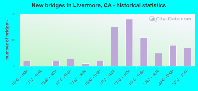
- New bridges - historical statistics
- 21900-1909
- 21920-1929
- 31930-1939
- 11940-1949
- 21950-1959
- 151960-1969
- 181970-1979
- 111980-1989
- 51990-1999
- 82000-2009
- 72010-2019

- Reconstructed bridges - Historical Statistics
- 11930-1939
- 01940-1949
- 01950-1959
- 21960-1969
- 11970-1979
- 11980-1989
- 21990-1999
- 12000-2009
- 52010-2019


- Bridge Condition - Deck
- 35.9%Good
- 51.3%Fair
- 12.8%Poor

- Bridge Condition - Superstructure
- 68.3%Good
- 4.9%Satisfactory
- 22.0%Fair
- 4.9%Poor

- Bridge Condition - Substructure
- 85.4%Good
- 12.2%Fair
- 2.4%Poor

- Bridge Condition - Channel
- 32.5%Excellent
- 25.0%Very good
- 20.0%Good
- 17.5%Satisfactory
- 5.0%Fair

- Bridge Condition - Culverts
- 15.4%Good
- 76.9%Satisfactory
- 7.7%Fair
Find on map >> Show street view
Structure Number: 33C0382, Location: 0.3 MI EAST OF 1ST ST (Lat: 37.696328, Lng: -121.737539), Route carried "on" structure: City street , Year Built: 1985, Status: Open, Structure Length: 1.89m (6.20ft), Average Daily Traffic: 8,700 (year 2009), Truck Traffic: 5%, Average Future Daily Traffic: 2,735 (year 2037), Design Load: HS 20, Features Intersected: ARROYO SECO, Facility Carried by Structure: LAS POSITAS RD
Minimum Vertical Clearance: 30+ m (98+ ft), Kilometerpoint: 0.000, Lanes on structure: 2, Owner: City or Municipal Highway Agency, Approaching Roadway Width: 15.6m (51.2ft), Skew: 1 degrees, Material/Design: Concrete continuous, Design/Construction: Culvert, Number Of Spans In Main Unit: 4, Length of Maximum Span: 4.6m (15.1ft), Curb or Sidewalk Widths: Left: 1.5m (4.9ft), Right: 1.5m (4.9ft), Curb-To-Curb Width: 15.6m (51.2ft), Out-to-Out Width: 19.4m (63.6ft)
Condition: Channel: Excellent, Culverts: Satisfactory, Operating Rating: 54.1 metric tons, Method Used To Determine Operating Rating: Field evaluation and documented engineering judgment, Inventory Rating: 32.4 metric tons, Method Used To Determine Inventory Rating: Field evaluation and documented engineering judgment, Structural Evaluation: Equal to present minimum criteria, Deck Geometry: Superior to present desirable criteria, Waterway Adequacy: Superior to present desirable criteria, Approach Roadway Alignment: Equal to present desirable criteria, Designated Inspection Frequency: Every 48 months, Inspection Date: October 2019, Deck Structure Type: Concrete Cast-file-Place, Wearing Surface/Protective System: Wearing Surface: Bituminous
Find on map >> Show street view
Structure Number: 33C0383, Location: 500' W LAS POSITAS RD (Lat: 37.698531, Lng: -121.740014), Route carried "on" structure: City street , Year Built: 1985, Status: Open, Structure Length: 1.83m (6.00ft), Average Daily Traffic: 1,000 (year 1990), Truck Traffic: 10%, Average Future Daily Traffic: 2,406 (year 2037), Design Load: HS 20, Features Intersected: ARROYO SECO, Facility Carried by Structure: ARROYO VISTA
Minimum Vertical Clearance: 30+ m (98+ ft), Kilometerpoint: 0.000, Lanes on structure: 2, Owner: City or Municipal Highway Agency, Approaching Roadway Width: 15.2m (49.9ft), Skew: 1 degrees, Material/Design: Concrete continuous, Design/Construction: Culvert, Number Of Spans In Main Unit: 4, Length of Maximum Span: 4.6m (15.1ft), Curb or Sidewalk Widths: Left: 1.5m (4.9ft), Right: 1.5m (4.9ft), Curb-To-Curb Width: 15.2m (49.9ft), Out-to-Out Width: 19.2m (63.0ft)
Condition: Channel: Excellent, Culverts: Satisfactory, Operating Rating: 54.1 metric tons, Method Used To Determine Operating Rating: Field evaluation and documented engineering judgment, Inventory Rating: 32.4 metric tons, Method Used To Determine Inventory Rating: Field evaluation and documented engineering judgment, Structural Evaluation: Equal to present minimum criteria, Deck Geometry: Superior to present desirable criteria, Waterway Adequacy: Superior to present desirable criteria, Approach Roadway Alignment: Equal to present desirable criteria, Designated Inspection Frequency: Every 48 months, Inspection Date: October 2019, Deck Structure Type: Concrete Cast-file-Place, Wearing Surface/Protective System: Wearing Surface: Bituminous
Find on map >> Show street view
Structure Number: 33C0385, Location: 0.9 MI S OF I-580 (Lat: 37.696619, Lng: -121.717900), Route carried "on" structure: City street , Year Built: 1987, Status: Open, Structure Length: 6.80m (22.31ft), Average Daily Traffic: 19,500 (year 2009), Truck Traffic: 10%, Average Future Daily Traffic: 33,261 (year 2041), Design Load: HS 20+Mod, Features Intersected: UP RR,ACE, FLOOD CONTROL, Facility Carried by Structure: VASCO ROAD
Minimum Vertical Clearance: 30+ m (98+ ft), Kilometerpoint: 0.000, Lanes on structure: 4, Owner: City or Municipal Highway Agency, Approaching Roadway Width: 25.7m (84.3ft), Skew: 21 degrees, Material/Design: Prestressed concrete continuous, Design/Construction: Box Beam or Girders - Multiple, Number Of Spans In Main Unit: 2, Length of Maximum Span: 33.6m (110.2ft), Curb or Sidewalk Widths: Left: 1.5m (4.9ft), Right: 1.5m (4.9ft), Curb-To-Curb Width: 20.8m (68.2ft), Out-to-Out Width: 25.7m (84.3ft)
Condition: Deck: Poor, Superstructure: Good, Substructure: Good, Channel: Excellent, Operating Rating: 51.5 metric tons, Method Used To Determine Operating Rating: Load and Resistance Factor Rating (LRFR) rating reported by rating factor(RF) method using HL-93 loadings, Inventory Rating: 34.7 metric tons, Method Used To Determine Inventory Rating: Load and Resistance Factor Rating (LRFR) rating reported by rating factor(RF) method using HL-93 loadings, Structural Evaluation: Better than present minimum criteria, Deck Geometry: Superior to present desirable criteria, Underclear: Superior to present desirable criteria, Waterway Adequacy: Superior to present desirable criteria, Approach Roadway Alignment: Equal to present minimum criteria, Designated Inspection Frequency: Every 24 months, Inspection Date: November 2021, Deck Structure Type: Concrete Cast-file-Place
Find on map >> Show street view
Structure Number: 33C0395, Location: 0.5 MI E OF EL CHARRO RD (Lat: 37.694750, Lng: -121.839128), Route carried "on" structure: City street , Year Built: 2012, Status: Open, Structure Length: 3.05m (10.01ft), Average Daily Traffic: 12,660 (year 2013), Truck Traffic: 3%, Average Future Daily Traffic: 16,377 (year 2040), Design Load: HL 93, Features Intersected: ARROYO LAS POSITAS, Facility Carried by Structure: W JACK LONDON BLVD
Minimum Vertical Clearance: 30+ m (98+ ft), Kilometerpoint: 0.000, Lanes on structure: 2, Owner: City or Municipal Highway Agency, Approaching Roadway Width: 10.3m (33.8ft), Skew: 2 degrees, Material/Design: Prestressed concrete, Design/Construction: Box Beam or Girders - Multiple, Number Of Spans In Main Unit: 1, Length of Maximum Span: 30.5m (100.1ft), Curb or Sidewalk Widths: Left: 0.0m, Right: 2.4m (7.9ft), Curb-To-Curb Width: 10.3m (33.8ft), Out-to-Out Width: 13.5m (44.3ft)
Condition: Deck: Good, Superstructure: Good, Substructure: Good, Channel: Satisfactory, Operating Rating: 42.1 metric tons, Method Used To Determine Operating Rating: Assigned ratings based on Load and Resistance Factor Design (LRFD) reported by rating factor (RF) using HL93 loadings, Inventory Rating: 32.4 metric tons, Method Used To Determine Inventory Rating: Assigned ratings based on Load and Resistance Factor Design (LRFD) reported by rating factor (RF) using HL93 loadings, Structural Evaluation: Better than present minimum criteria, Deck Geometry: Meets minimum limits, Waterway Adequacy: Superior to present desirable criteria, Approach Roadway Alignment: Equal to present desirable criteria, Designated Inspection Frequency: Every 24 months, Inspection Date: August 2020, Deck Structure Type: Concrete Cast-file-Place
Find on map >> Show street view
Structure Number: 33C0397, Location: 1 MI N OF I-580 (Lat: 37.716497, Lng: -121.747861), Route carried "on" structure: City street , Year Built: 1981, Status: Open, Structure Length: 2.74m (8.99ft), Average Daily Traffic: 5,700 (year 2009), Truck Traffic: 2%, Average Future Daily Traffic: 1,091 (year 2041), Design Load: HS 20, Features Intersected: ALTAMONT CREEK, Facility Carried by Structure: SPRINGTOWN BLVD
Minimum Vertical Clearance: 30+ m (98+ ft), Kilometerpoint: 0.000, Lanes on structure: 2, Owner: City or Municipal Highway Agency, Approaching Roadway Width: 20.7m (67.9ft), Skew: 21 degrees, Material/Design: Steel, Design/Construction: Arch - Deck, Number Of Spans In Main Unit: 3, Length of Maximum Span: 9.1m (29.9ft), Curb or Sidewalk Widths: Left: 1.5m (4.9ft), Right: 1.5m (4.9ft), Curb-To-Curb Width: 20.7m (67.9ft), Out-to-Out Width: 29.0m (95.1ft)
Condition: Superstructure: Fair, Substructure: Good, Channel: Very good, Operating Rating: 54.1 metric tons, Method Used To Determine Operating Rating: Field evaluation and documented engineering judgment, Inventory Rating: 32.4 metric tons, Method Used To Determine Inventory Rating: Field evaluation and documented engineering judgment, Structural Evaluation: Somewhat better than minimum adequacy, Deck Geometry: Superior to present desirable criteria, Waterway Adequacy: Equal to present desirable criteria, Approach Roadway Alignment: Better than present minimum criteria, Designated Inspection Frequency: Every 24 months, Inspection Date: November 2021
Find on map >> Show street view
Structure Number: 33C0413, Location: 0.4 KM EAST OF S VASCO RD (Lat: 37.695750, Lng: -121.714789), Route carried "on" structure: City street , Year Built: 2000, Status: Open, Structure Length: 0.85m (2.79ft), Average Daily Traffic: 3,260 (year 2004), Truck Traffic: 4%, Average Future Daily Traffic: 4,508 (year 2043), Features Intersected: FLOOD CONTROL CHANNEL, Facility Carried by Structure: PATTERSON PASS RD
Minimum Vertical Clearance: 30+ m (98+ ft), Kilometerpoint: 0.000, Lanes on structure: 4, Owner: City or Municipal Highway Agency, Approaching Roadway Width: 20.8m (68.2ft), Skew: 20 degrees, Material/Design: Concrete continuous, Design/Construction: Culvert, Number Of Spans In Main Unit: 2, Length of Maximum Span: 4.2m (13.8ft), Curb or Sidewalk Widths: Left: 2.8m (9.2ft), Right: 2.8m (9.2ft), Curb-To-Curb Width: 20.8m (68.2ft), Out-to-Out Width: 31.8m (104.3ft)
Condition: Channel: Good, Culverts: Satisfactory, Operating Rating: 54.1 metric tons, Method Used To Determine Operating Rating: Field evaluation and documented engineering judgment, Inventory Rating: 32.4 metric tons, Method Used To Determine Inventory Rating: Field evaluation and documented engineering judgment, Structural Evaluation: Equal to present minimum criteria, Deck Geometry: Superior to present desirable criteria, Waterway Adequacy: Equal to present desirable criteria, Approach Roadway Alignment: Equal to present desirable criteria, Designated Inspection Frequency: Every 48 months, Inspection Date: November 2021
Find on map >> Show street view
Structure Number: 33C0415, Location: 0.1 KM W OF STATE RTE 84 (Lat: 37.699467, Lng: -121.741119), Route carried "on" structure: City street , Year Built: 1999, Status: Open, Structure Length: 1.80m (5.91ft), Average Daily Traffic: 2,650 (year 2009), Truck Traffic: 5%, Average Future Daily Traffic: 6,542 (year 2041), Features Intersected: ARROYO SECO, Facility Carried by Structure: SOUTHFRONT ROAD
Minimum Vertical Clearance: 30+ m (98+ ft), Kilometerpoint: 0.000, Lanes on structure: 5, Owner: City or Municipal Highway Agency, Approaching Roadway Width: 18.6m (61.0ft), Skew: 30 degrees, Material/Design: Concrete continuous, Design/Construction: Culvert, Number Of Spans In Main Unit: 4, Length of Maximum Span: 4.3m (14.1ft), Curb or Sidewalk Widths: Left: 1.5m (4.9ft), Right: 1.5m (4.9ft), Curb-To-Curb Width: 18.6m (61.0ft), Out-to-Out Width: 29.3m (96.1ft)
Condition: Channel: Fair, Culverts: Satisfactory, Operating Rating: 54.1 metric tons, Method Used To Determine Operating Rating: Field evaluation and documented engineering judgment, Inventory Rating: 32.4 metric tons, Method Used To Determine Inventory Rating: Field evaluation and documented engineering judgment, Structural Evaluation: Equal to present minimum criteria, Deck Geometry: High priority of corrective action, Waterway Adequacy: Equal to present desirable criteria, Approach Roadway Alignment: Equal to present minimum criteria, Designated Inspection Frequency: Every 24 months, Inspection Date: October 2021
Find on map >> Show street view
Structure Number: 33C0416, Location: 0.5 KM S. OF STATE RTE 84 (Lat: 37.691386, Lng: -121.744892), Route carried "on" structure: City street , Year Built: 1999, Status: Open, Structure Length: 6.82m (22.38ft), Average Daily Traffic: 2,392 (year 2003), Truck Traffic: 4%, Average Future Daily Traffic: 3,272 (year 2041), Design Load: HS 20+Mod, Features Intersected: UP RR, BNSF RY, & ACE, Facility Carried by Structure: NORTH MINES ROAD
Minimum Vertical Clearance: 30+ m (98+ ft), Kilometerpoint: 0.000, Lanes on structure: 4, Lanes under structure: 2, Toll: On toll road, Owner: City or Municipal Highway Agency, Approaching Roadway Width: 22.0m (72.2ft), Skew: 20 degrees, Material/Design: Prestressed concrete continuous, Design/Construction: Box Beam or Girders - Multiple, Number Of Spans In Main Unit: 2, Length of Maximum Span: 35.6m (116.8ft), Curb or Sidewalk Widths: Left: 1.5m (4.9ft), Right: 1.5m (4.9ft), Curb-To-Curb Width: 22.0m (72.2ft), Out-to-Out Width: 26.9m (88.3ft)
Condition: Deck: Fair, Superstructure: Good, Substructure: Good, Operating Rating: 54.1 metric tons, Method Used To Determine Operating Rating: Assigned rating based on Load Factor Design (LFD) reported in metric tons, Inventory Rating: 32.4 metric tons, Method Used To Determine Inventory Rating: Assigned rating based on Load Factor Design (LFD) reported in metric tons, Structural Evaluation: Better than present minimum criteria, Deck Geometry: Superior to present desirable criteria, Underclear: Equal to present minimum criteria, Approach Roadway Alignment: Equal to present desirable criteria, Designated Inspection Frequency: Every 24 months, Inspection Date: October 2021, Deck Structure Type: Concrete Cast-file-Place
Find on map >> Show street view
Structure Number: 33C0423, Location: 450 FT NW OF VINEYARD AVE (Lat: 37.645919, Lng: -121.786958), Route carried "on" structure: County highway , Year Built: 1940, Status: Open, Structure Length: 7.50m (24.61ft), Average Daily Traffic: 19,250 (year 2014), Truck Traffic: 5%, Average Future Daily Traffic: 11,050 (year 2043), Design Load: H 20, Features Intersected: ARROYO DEL VALLE, Facility Carried by Structure: VALLECITOS ROAD
Minimum Vertical Clearance: 30+ m (98+ ft), Kilometerpoint: 0.000, Lanes on structure: 2, Owner: County Highway Agency, Approaching Roadway Width: 12.2m (40.0ft), Skew: 1 degrees, Material/Design: Concrete continuous, Design/Construction: Slab, Number Of Spans In Main Unit: 8, Length of Maximum Span: 11.6m (38.1ft), Curb or Sidewalk Widths: Left: 0.6m (2.0ft), Right: 0.6m (2.0ft), Curb-To-Curb Width: 7.9m (25.9ft), Out-to-Out Width: 9.8m (32.2ft)
Condition: Deck: Fair, Superstructure: Fair, Substructure: Good, Channel: Satisfactory, Operating Rating: 46.7 metric tons, Method Used To Determine Operating Rating: Load Factor (LF), Inventory Rating: 28.2 metric tons, Method Used To Determine Inventory Rating: Load Factor (LF), Structural Evaluation: Somewhat better than minimum adequacy, Deck Geometry: High priority of corrective action, Waterway Adequacy: Better than present minimum criteria, Approach Roadway Alignment: Equal to present desirable criteria, Designated Inspection Frequency: Every 24 months, Inspection Date: November 2021, Deck Structure Type: Concrete Cast-file-Place
Find on map >> Show street view
Structure Number: 33C0424, Location: 600' NW LAS POSITAS ROAD (Lat: 37.699878, Lng: -121.741600), Route carried "on" structure: City street , Year Built: 1994, Status: Open, Structure Length: 1.80m (5.91ft), Average Daily Traffic: 19,950 (year 2009), Truck Traffic: 5%, Average Future Daily Traffic: 13,527 (year 2043), Features Intersected: ARROYO SECO, Facility Carried by Structure: FIRST STREET
Minimum Vertical Clearance: 30+ m (98+ ft), Kilometerpoint: 0.000, Lanes on structure: 7, Base Highway Network: Yes, Owner: City or Municipal Highway Agency, Approaching Roadway Width: 34.1m (111.9ft), Skew: 30 degrees, Material/Design: Concrete continuous, Design/Construction: Culvert, Number Of Spans In Main Unit: 4, Length of Maximum Span: 4.3m (14.1ft), Curb or Sidewalk Widths: Left: 3.6m (11.8ft), Right: 7.0m (23.0ft), Curb-To-Curb Width: 34.1m (111.9ft), Out-to-Out Width: 45.9m (150.6ft)
Condition: Channel: Very good, Culverts: Satisfactory, Operating Rating: 54.1 metric tons, Method Used To Determine Operating Rating: Field evaluation and documented engineering judgment, Inventory Rating: 32.4 metric tons, Method Used To Determine Inventory Rating: Field evaluation and documented engineering judgment, Structural Evaluation: Equal to present minimum criteria, Deck Geometry: Superior to present desirable criteria, Waterway Adequacy: Equal to present desirable criteria, Approach Roadway Alignment: Equal to present desirable criteria, Designated Inspection Frequency: Every 48 months, Inspection Date: October 2021
Find on map >> Show street view
Structure Number: 33C0425, Location: 150' SOUTH OF SCOTT ST (Lat: 37.686408, Lng: -121.758789), Route carried "on" structure: City street , Year Built: 1977, Status: Open, Structure Length: 5.91m (19.39ft), Average Daily Traffic: 27,400 (year 2009), Truck Traffic: 5%, Average Future Daily Traffic: 10,904 (year 2041), Design Load: HS 20+Mod, Features Intersected: UP RR, BNSF RY, & ACE, Facility Carried by Structure: FIRST STREET
Minimum Vertical Clearance: 7.04m (23.10ft), Kilometerpoint: 0.000, Lanes on structure: 4, Owner: City or Municipal Highway Agency, Approaching Roadway Width: 21.3m (69.9ft), Skew: 29 degrees, Material/Design: Prestressed concrete continuous, Design/Construction: Box Beam or Girders - Multiple, Number Of Spans In Main Unit: 3, Length of Maximum Span: 26.8m (87.9ft), Curb or Sidewalk Widths: Left: 0.0m, Right: 1.5m (4.9ft), Curb-To-Curb Width: 20.1m (65.9ft), Out-to-Out Width: 23.7m (77.8ft)
Condition: Deck: Fair, Superstructure: Good, Substructure: Good, Operating Rating: 80.0 metric tons, Method Used To Determine Operating Rating: Load Factor (LF), Inventory Rating: 32.4 metric tons, Method Used To Determine Inventory Rating: Load Factor (LF), Structural Evaluation: Better than present minimum criteria, Deck Geometry: Better than present minimum criteria, Underclear: Superior to present desirable criteria, Approach Roadway Alignment: Equal to present desirable criteria, Designated Inspection Frequency: Every 24 months, Inspection Date: October 2021, Deck Structure Type: Concrete Cast-file-Place
Find on map >> Show street view
Structure Number: 33C0426, Location: 500' N MOCHO STREET (Lat: 37.673953, Lng: -121.780044), Route carried "on" structure: City street , Year Built: 1939, Year Reconstructed: 1968, Status: Open, Structure Length: 3.13m (10.27ft), Average Daily Traffic: 18,200 (year 2009), Truck Traffic: 5%, Average Future Daily Traffic: 11,273 (year 2043), Design Load: H 20, Features Intersected: ARROYO MOCHO, Facility Carried by Structure: HOLMES STREET
Minimum Vertical Clearance: 30+ m (98+ ft), Kilometerpoint: 0.000, Lanes on structure: 4, Owner: City or Municipal Highway Agency, Approaching Roadway Width: 20.8m (68.2ft), Material/Design: Concrete continuous, Design/Construction: Slab, Number Of Spans In Main Unit: 5, Length of Maximum Span: 11.0m (36.1ft), Curb or Sidewalk Widths: Left: 1.5m (4.9ft), Right: 1.5m (4.9ft), Curb-To-Curb Width: 20.8m (68.2ft), Out-to-Out Width: 24.4m (80.1ft)
Condition: Deck: Good, Superstructure: Good, Substructure: Good, Channel: Very good, Operating Rating: 61.2 metric tons, Method Used To Determine Operating Rating: Load Factor (LF), Inventory Rating: 36.9 metric tons, Method Used To Determine Inventory Rating: Load Factor (LF), Structural Evaluation: Better than present minimum criteria, Deck Geometry: Superior to present desirable criteria, Waterway Adequacy: Equal to present desirable criteria, Approach Roadway Alignment: Equal to present desirable criteria, Designated Inspection Frequency: Every 48 months, Inspection Date: October 2021, Deck Structure Type: Concrete Cast-file-Place, Wearing Surface/Protective System: Wearing Surface: Bituminous
Find on map >> Show street view
Structure Number: 33C044, Location: 0.3 MI SE OF TASSAJARA RD (Lat: 37.730344, Lng: -121.862928), Route carried "on" structure: Business City street , Year Built: 2010, Status: Open, Structure Length: 3.58m (11.75ft), Average Daily Traffic: 4,000 (year 2014), Truck Traffic: 10%, Average Future Daily Traffic: 2,130 (year 2043), Design Load: HS 20+Mod, Features Intersected: KOBOLD CREEK, Facility Carried by Structure: FALLON ROAD
Minimum Vertical Clearance: 30+ m (98+ ft), Kilometerpoint: 0.000, Lanes on structure: 4, Owner: City or Municipal Highway Agency, Approaching Roadway Width: 18.3m (60.0ft), Skew: 23 degrees, Material/Design: Prestressed concrete, Design/Construction: Tee Beam, Number Of Spans In Main Unit: 1, Length of Maximum Span: 33.7m (110.6ft), Curb or Sidewalk Widths: Left: 0.0m, Right: 3.7m (12.1ft), Curb-To-Curb Width: 18.3m (60.0ft), Out-to-Out Width: 25.2m (82.7ft)
Condition: Deck: Fair, Superstructure: Good, Substructure: Good, Channel: Good, Operating Rating: 54.1 metric tons, Method Used To Determine Operating Rating: Assigned rating based on Load Factor Design (LFD) reported in metric tons, Inventory Rating: 32.4 metric tons, Method Used To Determine Inventory Rating: Assigned rating based on Load Factor Design (LFD) reported in metric tons, Structural Evaluation: Better than present minimum criteria, Deck Geometry: Somewhat better than minimum adequacy, Waterway Adequacy: Equal to present minimum criteria, Approach Roadway Alignment: Equal to present desirable criteria, Designated Inspection Frequency: Every 24 months, Inspection Date: October 2021, Deck Structure Type: Concrete Cast-file-Place
Find on map >> Show street view
Structure Number: 33C0448, Location: 1 MILE SW OF WETMORE (Lat: 37.637806, Lng: -121.763642), Route carried "on" structure: County highway , Year Built: 1930, Year Reconstructed: 1937, Status: Open, Structure Length: 0.76m (2.49ft), Average Daily Traffic: 2,800 (year 2014), Truck Traffic: 5%, Average Future Daily Traffic: 6,459 (year 2043), Features Intersected: DRY CREEK, Facility Carried by Structure: ARROYO ROAD
Minimum Vertical Clearance: 30+ m (98+ ft), Kilometerpoint: 0.000, Lanes on structure: 2, Owner: County Highway Agency, Approaching Roadway Width: 7.0m (23.0ft), Design/Construction: Stringer/Multi-beam, Number Of Spans In Main Unit: 1, Length of Maximum Span: 7.4m (24.3ft), Curb or Sidewalk Widths: Left: 0.3m (1.0ft), Right: 0.3m (1.0ft), Curb-To-Curb Width: 6.5m (21.3ft), Out-to-Out Width: 7.1m (23.3ft)
Condition: Deck: Poor, Superstructure: Poor, Substructure: Poor, Channel: Excellent, Operating Rating: 73.9 metric tons, Method Used To Determine Operating Rating: Load Factor (LF), Inventory Rating: 44.4 metric tons, Method Used To Determine Inventory Rating: Load Factor (LF), Structural Evaluation: Meets minimum limits, Deck Geometry: High priority of replacement, Waterway Adequacy: Equal to present desirable criteria, Approach Roadway Alignment: Equal to present minimum criteria, Length Of Structure Improvement: 0.76m (2.49ft), Designated Inspection Frequency: Every 24 months, Inspection Date: November 2021, Bridge Improvement Cost: $50,000, Roadway Improvement Cost: $23,000, Total Project Cost: $193,000 ( Estimate for 2017), Deck Structure Type: Concrete Cast-file-Place, Wearing Surface/Protective System: Wearing Surface: Bituminous
Find on map >> Show street view
Structure Number: 33C0485, Location: 0.2 MI S/O S LIVERMORE AV (Lat: 37.667039, Lng: -121.749736), Route carried "on" structure: City street , Year Built: 2003, Status: Open, Structure Length: 3.66m (12.01ft), Average Daily Traffic: 15,041 (year 2013), Truck Traffic: 5%, Average Future Daily Traffic: 18,363 (year 2039), Features Intersected: ARROYO MOCHO, Facility Carried by Structure: CONCANNON BLVD
Minimum Vertical Clearance: 30+ m (98+ ft), Kilometerpoint: 0.000, Lanes on structure: 2, Owner: City or Municipal Highway Agency, Approaching Roadway Width: 9.8m (32.2ft), Skew: 1 degrees, Material/Design: Concrete continuous, Design/Construction: Slab, Number Of Spans In Main Unit: 3, Length of Maximum Span: 12.2m (40.0ft), Curb-To-Curb Width: 9.8m (32.2ft), Out-to-Out Width: 10.0m (32.8ft)
Condition: Deck: Fair, Superstructure: Fair, Substructure: Good, Channel: Good, Operating Rating: 54.1 metric tons, Method Used To Determine Operating Rating: Field evaluation and documented engineering judgment, Inventory Rating: 32.4 metric tons, Method Used To Determine Inventory Rating: Field evaluation and documented engineering judgment, Structural Evaluation: Somewhat better than minimum adequacy, Deck Geometry: Meets minimum limits, Waterway Adequacy: Equal to present desirable criteria, Approach Roadway Alignment: Equal to present desirable criteria, Designated Inspection Frequency: Every 24 months, Inspection Date: November 2021, Deck Structure Type: Concrete Cast-file-Place
Find on map >> Show street view
Structure Number: 33 0026L, Location: 04-ALA-580-R8.29 (Lat: 37.717869, Lng: -121.700181), Route carried "under" structure: County highway , Year Built: 1969, Structure Length: 0. m, Average Daily Traffic: 2,000 (year 2009), Truck Traffic: 3%, Features Intersected: GREENVILLE ROAD, Facility Carried by Structure: INTERSTATE 580 EB
Minimum Vertical Clearance: 14.65m (48.06ft), Kilometerpoint: 0.000, Lanes on structure: 5, Lanes under structure: 2, Material/Design: Concrete continuous, Design/Construction: Box Beam or Girders - Multiple, Length of Maximum Span: 32.6m (107.0ft)
Find on map >> Show street view
Structure Number: 33 0026R, Location: 04-ALA-580-R8.29 (Lat: 37.718214, Lng: -121.700753), Route carried "under" structure: County highway , Year Built: 1969, Structure Length: 0. m, Average Daily Traffic: 2,000 (year 2009), Truck Traffic: 3%, Features Intersected: GREENVILLE ROAD, Facility Carried by Structure: INTERSTATE 580 WB
Minimum Vertical Clearance: 4.69m (15.39ft), Kilometerpoint: 0.000, Lanes on structure: 4, Lanes under structure: 2, Material/Design: Concrete continuous, Design/Construction: Box Beam or Girders - Multiple, Length of Maximum Span: 30.5m (100.1ft)
Find on map >> Show street view
Structure Number: 33 0153, Location: 04-ALA-580-12.53 (Lat: 37.701114, Lng: -121.773553), Route carried "under" structure: County highway , Year Built: 1972, Structure Length: 0. m, Average Daily Traffic: 2,000 (year 2009), Truck Traffic: 3%, Features Intersected: NORTH LIVERMORE AVE, Facility Carried by Structure: INTERSTATE 580
Minimum Vertical Clearance: 4.57m (14.99ft), Kilometerpoint: 0.000, Lanes on structure: 11, Lanes under structure: 6, Material/Design: Concrete continuous, Design/Construction: Box Beam or Girders - Multiple, Length of Maximum Span: 27.1m (88.9ft)
Find on map >> Show street view
Structure Number: 33 0389, Location: 04-ALA-580-10.69-LVMR (Lat: 37.702197, Lng: -121.740267), Route carried "under" structure: Interstate 580, Year Built: 1965, Structure Length: 0. m, Average Daily Traffic: 197,000 (year 2020), Truck Traffic: 13%, Features Intersected: INTERSTATE 580, Facility Carried by Structure: FIRST STREET
Minimum Vertical Clearance: 5.13m (16.83ft), Kilometerpoint: 10.690, Lanes on structure: 4, Lanes under structure: 9, Material/Design: Prestressed concrete continuous, Design/Construction: Stringer/Multi-beam, Length of Maximum Span: 26.2m (86.0ft)
Find on map >> Show street view
Structure Number: 33 039, Location: 04-ALA-580-11.53 (Lat: 37.702519, Lng: -121.755564), Route carried "under" structure: Interstate 580, Year Built: 1972, Structure Length: 0. m, Average Daily Traffic: 197,000 (year 2020), Truck Traffic: 13%, Features Intersected: INTERSTATE 580, Facility Carried by Structure: LAS COLINAS RD
Minimum Vertical Clearance: 5.38m (17.65ft), Kilometerpoint: 11.530, Lanes on structure: 2, Lanes under structure: 13, Material/Design: Prestressed concrete continuous, Design/Construction: Box Beam or Girders - Multiple, Length of Maximum Span: 35.7m (117.1ft)
Find on map >> Show street view
Structure Number: 33 04, Location: 04-ALA-580-9.68 (Lat: 37.708678, Lng: -121.723533), Route carried "under" structure: Interstate 580, Year Built: 1970, Structure Length: 0. m, Average Daily Traffic: 175,000 (year 2020), Truck Traffic: 13%, Features Intersected: INTERSTATE 580, Facility Carried by Structure: VASCO ROAD
Minimum Vertical Clearance: 5.05m (16.57ft), Kilometerpoint: 9.680, Lanes on structure: 5, Lanes under structure: 11, Material/Design: Prestressed concrete continuous, Design/Construction: Stringer/Multi-beam, Length of Maximum Span: 28.7m (94.2ft)
Find on map >> Show street view
Structure Number: 33 0407, Location: 04-ALA-580-R5.93L (Lat: 37.718967, Lng: -121.659961), Route carried "under" structure: Interstate 580, Year Built: 1969, Structure Length: 0. m, Average Daily Traffic: 93,000 (year 2020), Truck Traffic: 12%, Features Intersected: INTERSTATE 580, Facility Carried by Structure: NORTH FLYNN ROAD
Minimum Vertical Clearance: 4.98m (16.34ft), Kilometerpoint: 5.930, Lanes on structure: 2, Lanes under structure: 11, Material/Design: Concrete continuous, Design/Construction: Box Beam or Girders - Multiple, Length of Maximum Span: 31.1m (102.0ft)
Find on map >> Show street view
Structure Number: 33 0408L, Location: 04-ALA-580-14.98 (Lat: 37.700592, Lng: -121.817878), Route carried "under" structure: Interstate 580, Year Built: 1972, Structure Length: 0. m, Average Daily Traffic: 184,000 (year 2010), Truck Traffic: 14%, Features Intersected: INTERSTATE 580, Facility Carried by Structure: AIRWAY BLVD SB
Minimum Vertical Clearance: 5.11m (16.77ft), Kilometerpoint: 14.980, Lanes on structure: 3, Lanes under structure: 8, Material/Design: Prestressed concrete continuous, Design/Construction: Box Beam or Girders - Multiple, Length of Maximum Span: 43.6m (143.0ft)
Find on map >> Show street view
Structure Number: 33 0408R, Location: 04-ALA-580-14.95-LVMR (Lat: 37.700506, Lng: -121.817689), Route carried "under" structure: Interstate 580, Year Built: 1999, Structure Length: 0. m, Average Daily Traffic: 184,000 (year 2010), Truck Traffic: 14%, Features Intersected: INTERSTATE 580, Facility Carried by Structure: AIRWAY BLVD NB
Minimum Vertical Clearance: 5.56m (18.24ft), Kilometerpoint: 14.950, Lanes on structure: 3, Lanes under structure: 10, Material/Design: Prestressed concrete continuous, Design/Construction: Box Beam or Girders - Single/Spread, Length of Maximum Span: 67.0m (219.8ft)
Find on map >> Show street view
Structure Number: 33 0711, Location: 04-ALA-084-R26.98-LVMR (Lat: 37.675925, Lng: -121.805594), Route carried "under" structure: State highway 84, Year Built: 2003, Structure Length: 0. m, Average Daily Traffic: 43,000 (year 2010), Truck Traffic: 3%, Features Intersected: STATE ROUTE 84 (ISABEL), Facility Carried by Structure: STANLEY BLVD
Minimum Vertical Clearance: 5.43m (17.81ft), Kilometerpoint: 26.980, Lanes on structure: 5, Lanes under structure: 6, Material/Design: Prestressed concrete continuous, Design/Construction: Box Beam or Girders - Multiple, Length of Maximum Span: 24.8m (81.4ft)
Find on map >> Show street view
Structure Number: 33 0712, Location: 04-ALA-084-R27.00-LVMR (Lat: 37.676625, Lng: -121.805508), Route carried "under" structure: State highway 84, Year Built: 2003, Structure Length: 0. m, Average Daily Traffic: 22,800 (year 2010), Truck Traffic: 3%, Features Intersected: STATE ROUTE 84 (ISABEL), Facility Carried by Structure: UNION PACIFIC RR
Minimum Vertical Clearance: 5.43m (17.81ft), Kilometerpoint: 27.000, Lanes under structure: 6, Material/Design: Prestressed concrete continuous, Design/Construction: Box Beam or Girders - Multiple, Length of Maximum Span: 22.4m (73.5ft)
Find on map >> Show street view
Structure Number: 33 0722, Location: 04-ALA-580-13.22 (Lat: 37.699258, Lng: -121.785189), Route carried "under" structure: Interstate 580, Year Built: 2011, Structure Length: 0. m, Average Daily Traffic: 208,000 (year 2017), Truck Traffic: 14%, Features Intersected: I-580,ARROYO LAS POSITAS, Facility Carried by Structure: PORTOLA AVE
Minimum Vertical Clearance: 5.63m (18.47ft), Kilometerpoint: 13.220, Lanes on structure: 2, Lanes under structure: 13, Material/Design: Concrete continuous, Design/Construction: Box Beam or Girders - Multiple, Length of Maximum Span: 47.0m (154.2ft)
Find on map >> Show street view
Structure Number: 33 0723, Location: 04-ALA-084-N28.15-LVMR (Lat: 37.700339, Lng: -121.802339), Route carried "under" structure: Interstate 580, Year Built: 2011, Structure Length: 0. m, Average Daily Traffic: 95,000 (year 2011), Truck Traffic: 4%, Features Intersected: INTERSTATE 580, Facility Carried by Structure: ST RTE 84 (ISABEL)
Minimum Vertical Clearance: 6.30m (20.67ft), Kilometerpoint: 14.160, Lanes on structure: 4, Lanes under structure: 12, Material/Design: Prestressed concrete continuous, Design/Construction: Box Beam or Girders - Multiple, Length of Maximum Span: 80.0m (262.5ft)
Find on map >> Show street view
Structure Number: 33C0013, Location: 0.4 MI E/O GREENVILLE RD (Lat: 37.721467, Lng: -121.696186), Route carried "under" structure: County highway , Year Built: 1908, Structure Length: 0. m, Average Daily Traffic: 400 (year 1976), Truck Traffic: 30%, Features Intersected: ALTAMONT PASS ROAD, Facility Carried by Structure: UP RR,BNSF RY,ACE
Minimum Vertical Clearance: 7.62m (25.00ft), Kilometerpoint: 0.000, Lanes under structure: 2, Material/Design: Steel, Design/Construction: Stringer/Multi-beam, Length of Maximum Span: 25.6m (84.0ft)
Find on map >> Show street view
Structure Number: 33C0109, Location: 3.7 MI E OF GREENVILLE RD (Lat: 37.746422, Lng: -121.655297), Route carried "under" structure: County highway , Year Built: 1907, Structure Length: 0. m, Average Daily Traffic: 400 (year 1976), Truck Traffic: 30%, Features Intersected: ALTAMONT PASS ROAD, Facility Carried by Structure: UP RR, BNSF, ACE
Minimum Vertical Clearance: 8.85m (29.04ft), Kilometerpoint: 0.000, Lanes under structure: 2, Material/Design: Steel, Design/Construction: Truss - Thru, Length of Maximum Span: 43.6m (143.0ft)
Find on map >> Show street view
Structure Number: 33C0196, Location: 0.1 MI S CHESTNUT ST (Lat: 37.682061, Lng: -121.777578), Route carried "under" structure: City street , Year Built: 1974, Structure Length: 0. m, Average Daily Traffic: 400 (year 1976), Truck Traffic: 30%, Features Intersected: N P STREET, Facility Carried by Structure: UP RR,BNSF,ACE
Minimum Vertical Clearance: 4.72m (15.49ft), Kilometerpoint: 0.000, Lanes under structure: 4, Material/Design: Prestressed concrete, Design/Construction: Box Beam or Girders - Multiple, Length of Maximum Span: 12.5m (41.0ft)
Find on map >> Show street view
Structure Number: 33C0197, Location: BETW CHESTNUT/RAILROAD (Lat: 37.684339, Lng: -121.769972), Route carried "under" structure: City street , Year Built: 1974, Structure Length: 0. m, Average Daily Traffic: 400 (year 1977), Truck Traffic: 30%, Features Intersected: LIVERMORE AVE, Facility Carried by Structure: UP RR,BNSF,ACE
Minimum Vertical Clearance: 4.67m (15.32ft), Kilometerpoint: 0.000, Lanes under structure: 4, Material/Design: Prestressed concrete, Design/Construction: Box Beam or Girders - Multiple, Length of Maximum Span: 12.5m (41.0ft)
Find on map >> Show street view
Structure Number: 33C0386, Location: 0.1 MI N STANLEY RD (Lat: 37.678822, Lng: -121.788403), Route carried "under" structure: City street , Year Built: 1987, Structure Length: 0. m, Average Daily Traffic: 25,700 (year 2009), Truck Traffic: 2%, Features Intersected: MURRIETA BLVD, Facility Carried by Structure: UP RR
Minimum Vertical Clearance: 4.60m (15.09ft), Kilometerpoint: 0.000, Lanes under structure: 4, Material/Design: Steel, Design/Construction: Stringer/Multi-beam, Length of Maximum Span: 14.3m (46.9ft)
Find on map >> Show street view
Structure Number: 33C0449L, Location: .15 MI S OF NATIONAL DR (Lat: 37.702975, Lng: -121.697114), Route carried "under" structure: City street , Year Built: 2008, Structure Length: 0. m, Average Daily Traffic: 3,902 (year 2011), Truck Traffic: 12%, Features Intersected: GREENVILLE RD, Facility Carried by Structure: UP RR, BNSF RY,ACE
Minimum Vertical Clearance: 5.20m (17.06ft), Kilometerpoint: 0.000, Lanes under structure: 4, Material/Design: Prestressed concrete continuous, Design/Construction: Box Beam or Girders - Single/Spread, Length of Maximum Span: 26.8m (87.9ft)
Find on map >> Show street view
Structure Number: 33C0450R, Location: .15 MI S OF NATIONAL DR (Lat: 37.702881, Lng: -121.697067), Route carried "under" structure: City street , Year Built: 2008, Structure Length: 0. m, Average Daily Traffic: 3,902 (year 2011), Truck Traffic: 12%, Features Intersected: GREENVILLE RD, Facility Carried by Structure: UP RR, BNSF RY,ACE
Minimum Vertical Clearance: 5.20m (17.06ft), Kilometerpoint: 0.000, Lanes under structure: 4, Material/Design: Prestressed concrete continuous, Design/Construction: Box Beam or Girders - Single/Spread, Length of Maximum Span: 26.8m (87.9ft)