Bridge Statistics for Lehi, Utah (UT)
Condition, Traffic, Stress, Structural Evaluation, Project Costs
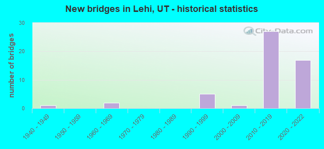
- New bridges - historical statistics
- 11940-1949
- 21960-1969
- 51990-1999
- 12000-2009
- 272010-2019
- 172020-2022

- Reconstructed bridges - Historical Statistics
- 22000-2009
- 12010-2019


- Bridge Condition - Deck
- 6.7%Very good
- 73.3%Good
- 20.0%Satisfactory

- Bridge Condition - Superstructure
- 33.3%Very good
- 60.0%Good
- 6.7%Satisfactory

- Bridge Condition - Substructure
- 23.3%Very good
- 60.0%Good
- 16.7%Satisfactory

- Bridge Condition - Channel
- 60.0%Very good
- 40.0%Satisfactory

- Bridge Condition - Culverts
- 33.3%Good
- 66.7%Satisfactory
Find on map >> Show street view
Structure Number: 49011F, Location: NORTH OF LEHI (Lat: 40.406228, Lng: -111.900158), Route carried "on" structure: County highway 2915, Year Built: 1995, Status: Open, Structure Length: 7.16m (23.49ft), Average Daily Traffic: 939 (year 2020), Average Future Daily Traffic: 1,174 (year 2040), Design Load: HS 20+Mod, Features Intersected: JORDAN RIVER, Facility Carried by Structure: CO.RD.-9600 NO.ST.
Minimum Vertical Clearance: 30+ m (98+ ft), Kilometerpoint: 1.281, Lanes on structure: 2, Owner: City or Municipal Highway Agency, Approaching Roadway Width: 9.8m (32.2ft), Skew: 3 degrees, Material/Design: Prestressed concrete continuous, Design/Construction: Stringer/Multi-beam, Number Of Spans In Main Unit: 2, Length of Maximum Span: 35.4m (116.1ft), Curb-To-Curb Width: 9.8m (32.2ft), Out-to-Out Width: 10.8m (35.4ft)
Condition: Deck: Good, Superstructure: Very good, Substructure: Good, Channel: Satisfactory, Operating Rating: 55.7 metric tons, Method Used To Determine Operating Rating: Load and Resistance Factor Rating (LRFR) rating reported by rating factor(RF) method using HL-93 loadings, Inventory Rating: 51.5 metric tons, Method Used To Determine Inventory Rating: Load Factor (LF) rating reported by rating factor (RF) method using MS18 loading, Structural Evaluation: Better than present minimum criteria, Deck Geometry: Equal to present minimum criteria, Waterway Adequacy: Equal to present desirable criteria, Approach Roadway Alignment: Equal to present desirable criteria, Designated Inspection Frequency: Every 24 months, Inspection Date: September 2021, Deck Structure Type: Concrete Cast-file-Place, Wearing Surface/Protective System: Wearing Surface: Monolithic Concrete, Deck Protection: Epoxy Coated Reinforcing
Find on map >> Show street view
Structure Number: 49095C, Location: 3500 S. 2775 N. (Lat: 40.429561, Lng: -111.901264), Route carried "on" structure: City street , Year Built: 2006, Status: Open, Structure Length: 3.90m (12.80ft), Average Daily Traffic: 1,890 (year 2020), Truck Traffic: 1%, Average Future Daily Traffic: 2,297 (year 2040), Design Load: HS 20+Mod, Features Intersected: UPRR TRACKS, Facility Carried by Structure: CLUB HOUSE DRIVE
Minimum Vertical Clearance: 30+ m (98+ ft), Kilometerpoint: 0.014, Lanes on structure: 2, Owner: City or Municipal Highway Agency, Approaching Roadway Width: 8.5m (27.9ft), Material/Design: Steel, Design/Construction: Stringer/Multi-beam, Number Of Spans In Main Unit: 1, Length of Maximum Span: 36.3m (119.1ft), Curb or Sidewalk Widths: Left: 0.4m (1.3ft), Right: 1.8m (5.9ft), Curb-To-Curb Width: 8.5m (27.9ft), Out-to-Out Width: 12.6m (41.3ft)
Condition: Deck: Satisfactory, Superstructure: Good, Substructure: Satisfactory, Operating Rating: 95.6 metric tons, Method Used To Determine Operating Rating: Load and Resistance Factor Rating (LRFR) rating reported by rating factor(RF) method using HL-93 loadings, Inventory Rating: 65.1 metric tons, Method Used To Determine Inventory Rating: Load Factor (LF) rating reported by rating factor (RF) method using MS18 loading, Structural Evaluation: Equal to present minimum criteria, Deck Geometry: Somewhat better than minimum adequacy, Approach Roadway Alignment: Equal to present desirable criteria, Designated Inspection Frequency: Every 24 months, Inspection Date: September 2021, Deck Structure Type: Concrete Cast-file-Place, Wearing Surface/Protective System: Wearing Surface: Latex Concrete, Deck Protection: Epoxy Coated Reinforcing
Find on map >> Show street view
Structure Number: C 235, Location: 3 MILES WEST OF LEHI (Lat: 40.387417, Lng: -111.905644), Route carried "on" structure: City street 2895, Year Built: 1947, Status: Open, Structure Length: 2.56m (8.40ft), Average Daily Traffic: 14,307 (year 2020), Average Future Daily Traffic: 17,884 (year 2040), Design Load: H 15, Features Intersected: JORDAN RIVER, Facility Carried by Structure: LEHI MAIN STREET
Minimum Vertical Clearance: 30+ m (98+ ft), Kilometerpoint: 2.333, Lanes on structure: 2, Owner: City or Municipal Highway Agency, Approaching Roadway Width: 7.9m (25.9ft), Material/Design: Steel, Design/Construction: Stringer/Multi-beam, Number Of Spans In Main Unit: 1, Length of Maximum Span: 24.1m (79.1ft), Curb or Sidewalk Widths: Left: 0.6m (2.0ft), Right: 0.6m (2.0ft), Curb-To-Curb Width: 7.9m (25.9ft), Out-to-Out Width: 9.8m (32.2ft)
Condition: Deck: Satisfactory, Superstructure: Good, Substructure: Satisfactory, Channel: Satisfactory, Operating Rating: 33.4 metric tons, Method Used To Determine Operating Rating: Load Factor (LF) rating reported by rating factor (RF) method using MS18 loading, Inventory Rating: 22.4 metric tons, Method Used To Determine Inventory Rating: Load Factor (LF) rating reported by rating factor (RF) method using MS18 loading, Structural Evaluation: Somewhat better than minimum adequacy, Deck Geometry: High priority of replacement, Waterway Adequacy: Equal to present minimum criteria, Approach Roadway Alignment: Equal to present minimum criteria, Designated Inspection Frequency: Every 24 months, Inspection Date: September 2021, Deck Structure Type: Concrete Cast-file-Place, Wearing Surface/Protective System: Wearing Surface: Bituminous, Membrane: Preformed Fabric
Find on map >> Show street view
Structure Number: D 843, Location: Just So. of Camp Williams (Lat: 40.425942, Lng: -111.926778), Route carried "on" structure: State highway 68, Year Built: 2010, Status: Open, Structure Length: 0.84m (2.76ft), Average Daily Traffic: 21,024 (year 2020), Truck Traffic: 13%, Average Future Daily Traffic: 26,280 (year 2040), Design Load: HS 20+Mod, Features Intersected: WILDLIFE CROSSING
Minimum Vertical Clearance: 30+ m (98+ ft), Kilometerpoint: 57.106, Lanes on structure: 4, Base Highway Network: Yes, Owner: State Highway Agency, Approaching Roadway Width: 32.2m (105.6ft), Material/Design: Concrete, Design/Construction: Slab, Number Of Spans In Main Unit: 1, Length of Maximum Span: 7.9m (25.9ft), Curb-To-Curb Width: 32.2m (105.6ft), Out-to-Out Width: 32.2m (105.6ft)
Condition: Deck: Satisfactory, Superstructure: Satisfactory, Substructure: Satisfactory, Channel: Very good, Operating Rating: 32.4 metric tons, Method Used To Determine Operating Rating: Load and Resistance Factor Rating (LRFR) rating reported by rating factor(RF) method using HL-93 loadings, Inventory Rating: 20.4 metric tons, Method Used To Determine Inventory Rating: Load Factor (LF) rating reported by rating factor (RF) method using MS18 loading, Structural Evaluation: Somewhat better than minimum adequacy, Deck Geometry: Superior to present desirable criteria, Waterway Adequacy: Superior to present desirable criteria, Approach Roadway Alignment: Equal to present desirable criteria, Designated Inspection Frequency: Every 24 months, Inspection Date: Febuary 2021, Deck Structure Type: Concrete Precast Panels, Wearing Surface/Protective System: Wearing Surface: Monolithic Concrete, Deck Protection: Epoxy Coated Reinforcing
Find on map >> Show street view
Structure Number: D 847, Location: 1 Mi. East of Alpine Int. (Lat: 40.432397, Lng: -111.868819), Route carried "on" structure: City street 2875, Year Built: 2012, Status: Open, Structure Length: 2.23m (7.32ft), Average Daily Traffic: 3,594 (year 2020), Average Future Daily Traffic: 4,493 (year 2040), Design Load: HL 93, Features Intersected: SR-92 COMMUTER LANES, Facility Carried by Structure: 1200 W. ST in LEHI
Minimum Vertical Clearance: 30+ m (98+ ft), Kilometerpoint: 0.036, Lanes on structure: 2, Lanes under structure: 2, Owner: State Highway Agency, Approaching Roadway Width: 17.1m (56.1ft), Skew: 20 degrees, Material/Design: Concrete, Design/Construction: Culvert, Number Of Spans In Main Unit: 1, Length of Maximum Span: 20.1m (65.9ft), Curb or Sidewalk Widths: Left: 2.7m (8.9ft), Right: 2.7m (8.9ft), Curb-To-Curb Width: 17.1m (56.1ft), Out-to-Out Width: 28.4m (93.2ft)
Condition: Culverts: Satisfactory, Operating Rating: 53.8 metric tons, Method Used To Determine Operating Rating: Load and Resistance Factor Rating (LRFR) rating reported by rating factor(RF) method using HL-93 loadings, Inventory Rating: 49.6 metric tons, Method Used To Determine Inventory Rating: Load and Resistance Factor Rating (LRFR) rating reported by rating factor(RF) method using HL-93 loadings, Structural Evaluation: Equal to present minimum criteria, Deck Geometry: Superior to present desirable criteria, Underclear: Somewhat better than minimum adequacy, Approach Roadway Alignment: Equal to present desirable criteria, Designated Inspection Frequency: Every 24 months, Inspection Date: Febuary 2021
Find on map >> Show street view
Structure Number: D 848, Location: 2.8 Mi. E. Alpine Intchg. (Lat: 40.432108, Lng: -111.839072), Route carried "on" structure: State highway 92, Year Built: 2012, Status: Open, Structure Length: 3.88m (12.73ft), Average Daily Traffic: 21,761 (year 2020), Truck Traffic: 20%, Average Future Daily Traffic: 27,201 (year 2040), Design Load: HL 93, Features Intersected: WB COMMUTER LANES
Minimum Vertical Clearance: 30+ m (98+ ft), Kilometerpoint: 4.829, Lanes on structure: 4, Lanes under structure: 2, Owner: State Highway Agency, Approaching Roadway Width: 25.0m (82.0ft), Skew: 26 degrees, Material/Design: Concrete, Design/Construction: Culvert, Number Of Spans In Main Unit: 1, Length of Maximum Span: 36.9m (121.1ft), Curb-To-Curb Width: 25.0m (82.0ft), Out-to-Out Width: 28.4m (93.2ft)
Condition: Culverts: Satisfactory, Operating Rating: 32.4 metric tons, Method Used To Determine Operating Rating: Load and Resistance Factor Rating (LRFR) rating reported by rating factor(RF) method using HL-93 loadings, Inventory Rating: 32.1 metric tons, Method Used To Determine Inventory Rating: Load and Resistance Factor Rating (LRFR) rating reported by rating factor(RF) method using HL-93 loadings, Structural Evaluation: Equal to present minimum criteria, Deck Geometry: Superior to present desirable criteria, Underclear: Meets minimum limits, Approach Roadway Alignment: Equal to present desirable criteria, Designated Inspection Frequency: Every 24 months, Inspection Date: Febuary 2021
Find on map >> Show street view
Structure Number: F 11, Location: IN LEHI (Lat: 40.394064, Lng: -111.840869), Route carried "on" structure: City street 2930, Year Built: 1964, Year Reconstructed: 2011, Status: Open, Structure Length: 6.39m (20.96ft), Average Daily Traffic: 3,213 (year 2020), Average Future Daily Traffic: 4,016 (year 2040), Design Load: HS 20+Mod, Features Intersected: US-89 (SR-89) & UPRR, Facility Carried by Structure: 5TH-6TH EAST ST
Minimum Vertical Clearance: 30+ m (98+ ft), Kilometerpoint: 0.664, Lanes on structure: 2, Lanes under structure: 4, Owner: State Highway Agency, Approaching Roadway Width: 9.8m (32.2ft), Material/Design: Prestressed concrete, Design/Construction: Stringer/Multi-beam, Number Of Spans In Main Unit: 4, Length of Maximum Span: 20.0m (65.6ft), Curb or Sidewalk Widths: Left: 1.2m (3.9ft), Right: 1.2m (3.9ft), Curb-To-Curb Width: 9.8m (32.2ft), Out-to-Out Width: 12.8m (42.0ft)
Condition: Deck: Good, Superstructure: Satisfactory, Substructure: Satisfactory, Operating Rating: 63.5 metric tons, Method Used To Determine Operating Rating: Load and Resistance Factor Rating (LRFR) rating reported by rating factor(RF) method using HL-93 loadings, Inventory Rating: 32.1 metric tons, Method Used To Determine Inventory Rating: Load Factor (LF) rating reported by rating factor (RF) method using MS18 loading, Structural Evaluation: Equal to present minimum criteria, Deck Geometry: Meets minimum limits, Underclear: High priority of corrective action, Approach Roadway Alignment: Equal to present minimum criteria, Designated Inspection Frequency: Every 24 months, Inspection Date: Febuary 2021, Deck Structure Type: Concrete Cast-file-Place, Wearing Surface/Protective System: Wearing Surface: Bituminous
Find on map >> Show street view
Structure Number: F 787, Location: 0.7mi.west of I-15 Int. (Lat: 40.377028, Lng: -111.833664), Route carried "on" structure: State highway 145, Year Built: 2010, Status: Open, Structure Length: 6.23m (20.44ft), Average Daily Traffic: 42,051 (year 2020), Truck Traffic: 11%, Average Future Daily Traffic: 52,564 (year 2040), Design Load: HL 93, Features Intersected: UPRR AND UTA TRACK
Minimum Vertical Clearance: 30+ m (98+ ft), Kilometerpoint: 9.181, Lanes on structure: 6, Owner: State Highway Agency, Approaching Roadway Width: 31.7m (104.0ft), Skew: 35 degrees, Material/Design: Prestressed concrete, Design/Construction: Stringer/Multi-beam, Number Of Spans In Main Unit: 1, Length of Maximum Span: 60.2m (197.5ft), Curb or Sidewalk Widths: Left: 1.8m (5.9ft), Right: 1.8m (5.9ft), Curb-To-Curb Width: 31.7m (104.0ft), Out-to-Out Width: 38.4m (126.0ft)
Condition: Deck: Satisfactory, Superstructure: Very good, Substructure: Good, Operating Rating: 47.0 metric tons, Method Used To Determine Operating Rating: Load and Resistance Factor Rating (LRFR) rating reported by rating factor(RF) method using HL-93 loadings, Inventory Rating: 13.3 metric tons, Method Used To Determine Inventory Rating: Load and Resistance Factor Rating (LRFR) rating reported by rating factor(RF) method using HL-93 loadings, Structural Evaluation: High priority of corrective action, Deck Geometry: Superior to present desirable criteria, Underclear: Meets minimum limits, Approach Roadway Alignment: Equal to present desirable criteria, Designated Inspection Frequency: Every 24 months, Inspection Date: Febuary 2021, Deck Structure Type: Concrete Cast-file-Place, Wearing Surface/Protective System: Wearing Surface: Epoxy Overlay, Deck Protection: Epoxy Coated Reinforcing
Find on map >> Show street view
Structure Number: F 797, Location: 2Mi. E. of Alpine Intchg. (Lat: 40.432300, Lng: -111.850086), Route carried "on" structure: Alternate State highway 92, Year Built: 2012, Status: Open, Structure Length: 3.75m (12.30ft), Average Daily Traffic: 21,761 (year 2020), Truck Traffic: 20%, Average Future Daily Traffic: 27,201 (year 2040), Design Load: HL 93, Features Intersected: CENTER ST. in LEHI
Minimum Vertical Clearance: 30+ m (98+ ft), Kilometerpoint: 3.164, Lanes on structure: 2, Lanes under structure: 5, Owner: State Highway Agency, Approaching Roadway Width: 17.1m (56.1ft), Skew: 30 degrees, Material/Design: Prestressed concrete, Design/Construction: Stringer/Multi-beam, Number Of Spans In Main Unit: 1, Length of Maximum Span: 36.6m (120.1ft), Curb-To-Curb Width: 17.1m (56.1ft), Out-to-Out Width: 18.6m (61.0ft)
Condition: Deck: Satisfactory, Superstructure: Good, Substructure: Good, Operating Rating: 46.7 metric tons, Method Used To Determine Operating Rating: Load and Resistance Factor Rating (LRFR) rating reported by rating factor(RF) method using HL-93 loadings, Inventory Rating: 29.8 metric tons, Method Used To Determine Inventory Rating: Load Factor (LF) rating reported by rating factor (RF) method using MS18 loading, Structural Evaluation: Better than present minimum criteria, Deck Geometry: Superior to present desirable criteria, Underclear: Superior to present desirable criteria, Approach Roadway Alignment: Equal to present desirable criteria, Designated Inspection Frequency: Every 24 months, Inspection Date: Febuary 2021, Deck Structure Type: Concrete Cast-file-Place, Wearing Surface/Protective System: Wearing Surface: Integral Concrete, Deck Protection: Epoxy Coated Reinforcing
Find on map >> Show street view
Structure Number: F 882, Location: IN LEHI (Lat: 40.395617, Lng: -111.840147), Route carried "on" structure: City street 2930, Year Built: 2018, Status: Open, Structure Length: 6.99m (22.93ft), Average Daily Traffic: 3,213 (year 2020), Average Future Daily Traffic: 4,016 (year 2040), Design Load: HS 20+Mod, Features Intersected: I-15 (SR-15) NBL AND SBL, Facility Carried by Structure: 6TH EAST
Minimum Vertical Clearance: 30+ m (98+ ft), Kilometerpoint: 0.850, Lanes on structure: 2, Lanes under structure: 12, Owner: State Highway Agency, Approaching Roadway Width: 9.8m (32.2ft), Skew: 1 degrees, Material/Design: Prestressed concrete, Design/Construction: Stringer/Multi-beam, Number Of Spans In Main Unit: 2, Length of Maximum Span: 33.4m (109.6ft), Curb or Sidewalk Widths: Left: 1.8m (5.9ft), Right: 1.8m (5.9ft), Curb-To-Curb Width: 9.8m (32.2ft), Out-to-Out Width: 14.9m (48.9ft)
Condition: Deck: Good, Superstructure: Good, Substructure: Good, Operating Rating: 45.4 metric tons, Method Used To Determine Operating Rating: Load and Resistance Factor Rating (LRFR) rating reported by rating factor(RF) method using HL-93 loadings, Inventory Rating: 35.6 metric tons, Method Used To Determine Inventory Rating: Load and Resistance Factor Rating (LRFR) rating reported by rating factor(RF) method using HL-93 loadings, Structural Evaluation: Better than present minimum criteria, Deck Geometry: Meets minimum limits, Underclear: Meets minimum limits, Approach Roadway Alignment: Equal to present desirable criteria, Designated Inspection Frequency: Every 24 months, Inspection Date: Febuary 2021, Deck Structure Type: Concrete Cast-file-Place, Wearing Surface/Protective System: Wearing Surface: Epoxy Overlay, Deck Protection: Epoxy Coated Reinforcing
Find on map >> Show street view
Structure Number: F 886, Location: Lehi (Lat: 40.423614, Lng: -111.883369), Route carried "on" structure: City street 2878, Year Built: 2019, Status: Open, Structure Length: 8.25m (27.07ft), Average Daily Traffic: 988 (year 2020), Average Future Daily Traffic: 1,235 (year 2040), Design Load: HL 93, Features Intersected: I-15, Facility Carried by Structure: Triumph Blvd
Minimum Vertical Clearance: 30+ m (98+ ft), Kilometerpoint: 9.901, Lanes on structure: 8, Lanes under structure: 14, Owner: State Highway Agency, Approaching Roadway Width: 47.0m (154.2ft), Skew: 20 degrees, Material/Design: Prestressed concrete, Design/Construction: Stringer/Multi-beam, Number Of Spans In Main Unit: 2, Length of Maximum Span: 45.4m (149.0ft), Curb or Sidewalk Widths: Left: 0.0m, Right: 1.8m (5.9ft), Curb-To-Curb Width: 40.5m (132.9ft), Out-to-Out Width: 47.0m (154.2ft)
Condition: Deck: Satisfactory, Superstructure: Good, Substructure: Good, Operating Rating: 43.4 metric tons, Method Used To Determine Operating Rating: Load and Resistance Factor Rating (LRFR) rating reported by rating factor(RF) method using HL-93 loadings, Inventory Rating: 33.4 metric tons, Method Used To Determine Inventory Rating: Load and Resistance Factor Rating (LRFR) rating reported by rating factor(RF) method using HL-93 loadings, Structural Evaluation: Better than present minimum criteria, Deck Geometry: Superior to present desirable criteria, Underclear: Meets minimum limits, Approach Roadway Alignment: Equal to present desirable criteria, Designated Inspection Frequency: Every 24 months, Inspection Date: Febuary 2021, Deck Structure Type: Concrete Precast Panels, Wearing Surface/Protective System: Deck Protection: Epoxy Coated Reinforcing
Find on map >> Show street view
Structure Number: 1C 783, Location: LEHI MAIN ST.INTERCHANGE (Lat: 40.387958, Lng: -111.833331), Route carried "on" structure: Interstate 15, Year Built: 1993, Year Reconstructed: 2019, Status: Open, Structure Length: 6.24m (20.47ft), Average Daily Traffic: 149,034 (year 2020), Truck Traffic: 17%, Average Future Daily Traffic: 186,293 (year 2040), Design Load: HS 20, Features Intersected: LEHI MAIN ST, SR-73
Minimum Vertical Clearance: 30+ m (98+ ft), Kilometerpoint: 450.655, Lanes on structure: 6, Lanes under structure: 6, Base Highway Network: Yes, Owner: State Highway Agency, Approaching Roadway Width: 29.8m (97.8ft), Skew: 1 degrees, Material/Design: Steel, Design/Construction: Stringer/Multi-beam, Number Of Spans In Main Unit: 1, Length of Maximum Span: 61.6m (202.1ft), Curb-To-Curb Width: 29.8m (97.8ft), Out-to-Out Width: 30.7m (100.7ft)
Condition: Deck: Good, Superstructure: Good, Substructure: Good, Operating Rating: 67.1 metric tons, Method Used To Determine Operating Rating: Load and Resistance Factor Rating (LRFR) rating reported by rating factor(RF) method using HL-93 loadings, Inventory Rating: 45.7 metric tons, Method Used To Determine Inventory Rating: Load and Resistance Factor Rating (LRFR) rating reported by rating factor(RF) method using HL-93 loadings, Structural Evaluation: Better than present minimum criteria, Deck Geometry: Superior to present desirable criteria, Underclear: Equal to present minimum criteria, Approach Roadway Alignment: Equal to present desirable criteria, Designated Inspection Frequency: Every 24 months, Inspection Date: Febuary 2021, Deck Structure Type: Concrete Cast-file-Place, Wearing Surface/Protective System: Wearing Surface: Latex Concrete, Deck Protection: Epoxy Coated Reinforcing
Find on map >> Show street view
Structure Number: 1E 2733, Location: Lehi Main to SR-92 (Lat: 40.426942, Lng: -111.885556), Route carried "on" structure: Ramp Interstate 15, Year Built: 2020, Status: Open, Structure Length: 0.95m (3.12ft), Average Daily Traffic: 177,100 (year 2020), Truck Traffic: 17%, Average Future Daily Traffic: 221,375 (year 2040), Design Load: HL 93, Features Intersected: I-15 NB On Ramp
Minimum Vertical Clearance: 30.48m (100.00ft), Kilometerpoint: 455.444, Lanes on structure: 1, Lanes under structure: 1, Owner: State Highway Agency, Approaching Roadway Width: 8.5m (27.9ft), Skew: 4 degrees, Material/Design: Concrete, Design/Construction: Culvert, Number Of Spans In Main Unit: 1, Length of Maximum Span: 9.5m (31.2ft), Curb-To-Curb Width: 8.5m (27.9ft), Out-to-Out Width: 47.5m (155.8ft)
Condition: Culverts: Good, Operating Rating: 55.1 metric tons, Method Used To Determine Operating Rating: Load and Resistance Factor Rating (LRFR) rating reported by rating factor(RF) method using HL-93 loadings, Inventory Rating: 42.1 metric tons, Method Used To Determine Inventory Rating: Load and Resistance Factor Rating (LRFR) rating reported by rating factor(RF) method using HL-93 loadings, Structural Evaluation: Better than present minimum criteria, Deck Geometry: Superior to present desirable criteria, Approach Roadway Alignment: Equal to present desirable criteria, Designated Inspection Frequency: Every 24 months, Inspection Date: Febuary 2021, Deck Structure Type: Concrete Cast-file-Place, Wearing Surface/Protective System: Wearing Surface: Bituminous, Deck Protection: Epoxy Coated Reinforcing
Find on map >> Show street view
Structure Number: 1F 883, Location: I-15 NB Over Lehi 100 E (Lat: 40.399722, Lng: -111.846944), Route carried "on" structure: State highway I-15, Year Built: 2020, Status: Open, Structure Length: 1.93m (6.33ft), Average Daily Traffic: 167,079 (year 2020), Truck Traffic: 14%, Average Future Daily Traffic: 208,850 (year 2040), Design Load: HL 93, Features Intersected: 100 East
Minimum Vertical Clearance: 30.18m (99.02ft), Kilometerpoint: 450.616, Lanes on structure: 6, Lanes under structure: 2, Base Highway Network: Yes, Owner: State Highway Agency, Approaching Roadway Width: 29.7m (97.4ft), Material/Design: Concrete, Design/Construction: Stringer/Multi-beam, Number Of Spans In Main Unit: 1, Length of Maximum Span: 18.6m (61.0ft), Curb-To-Curb Width: 29.7m (97.4ft), Out-to-Out Width: 30.6m (100.4ft)
Condition: Deck: Good, Superstructure: Very good, Substructure: Very good, Operating Rating: 57.7 metric tons, Method Used To Determine Operating Rating: Load and Resistance Factor Rating (LRFR) rating reported by rating factor(RF) method using HL-93 loadings, Inventory Rating: 33.0 metric tons, Method Used To Determine Inventory Rating: Load and Resistance Factor Rating (LRFR) rating reported by rating factor(RF) method using HL-93 loadings, Structural Evaluation: Equal to present desirable criteria, Deck Geometry: Superior to present desirable criteria, Underclear: Better than present minimum criteria, Approach Roadway Alignment: Equal to present desirable criteria, Designated Inspection Frequency: Every 24 months, Inspection Date: Febuary 2021, Deck Structure Type: Concrete Cast-file-Place, Wearing Surface/Protective System: Wearing Surface: Monolithic Concrete, Deck Protection: Epoxy Coated Reinforcing
Find on map >> Show street view
Structure Number: 1F 884, Location: I-15 OVER 300 W IN LEHI (Lat: 40.404167, Lng: -111.853889), Route carried "on" structure: Interstate I-15, Year Built: 2020, Status: Open, Structure Length: 3.17m (10.40ft), Average Daily Traffic: 167,079 (year 2020), Truck Traffic: 14%, Average Future Daily Traffic: 208,850 (year 2040), Design Load: HL 93, Features Intersected: I-15 OVER 300 WEST
Minimum Vertical Clearance: 30.48m (100.00ft), Kilometerpoint: 452.226, Lanes on structure: 7, Lanes under structure: 2, Base Highway Network: Yes, Owner: State Highway Agency, Approaching Roadway Width: 30.2m (99.1ft), Skew: 4 degrees, Material/Design: Concrete, Design/Construction: Stringer/Multi-beam, Number Of Spans In Main Unit: 1, Length of Maximum Span: 30.1m (98.8ft), Curb-To-Curb Width: 30.2m (99.1ft), Out-to-Out Width: 33.6m (110.2ft)
Condition: Deck: Good, Superstructure: Very good, Substructure: Good, Operating Rating: 58.3 metric tons, Method Used To Determine Operating Rating: Load and Resistance Factor Rating (LRFR) rating reported by rating factor(RF) method using HL-93 loadings, Inventory Rating: 32.4 metric tons, Method Used To Determine Inventory Rating: Load and Resistance Factor Rating (LRFR) rating reported by rating factor(RF) method using HL-93 loadings, Structural Evaluation: Better than present minimum criteria, Deck Geometry: Somewhat better than minimum adequacy, Underclear: Superior to present desirable criteria, Approach Roadway Alignment: Equal to present desirable criteria, Designated Inspection Frequency: Every 24 months, Inspection Date: July 2021, Deck Structure Type: Concrete Precast Panels, Wearing Surface/Protective System: Wearing Surface: Monolithic Concrete, Membrane: Epoxy, Deck Protection: Epoxy Coated Reinforcing
Find on map >> Show street view
Structure Number: 1F 885, Location: I-15 LEHI MAIN OVER UTA (Lat: 40.407497, Lng: -111.253667), Route carried "on" structure: Interstate 15, Year Built: 2020, Status: Open, Structure Length: 6.46m (21.19ft), Average Daily Traffic: 149,034 (year 2020), Truck Traffic: 17%, Average Future Daily Traffic: 186,293 (year 2040), Design Load: HL 93, Features Intersected: UTA Tracks
Minimum Vertical Clearance: 30+ m (98+ ft), Kilometerpoint: 453.030, Lanes on structure: 7, Base Highway Network: Yes, Owner: State Highway Agency, Approaching Roadway Width: 30.5m (100.1ft), Skew: 6 degrees, Material/Design: Concrete, Design/Construction: Stringer/Multi-beam, Number Of Spans In Main Unit: 1, Length of Maximum Span: 61.3m (201.1ft), Curb-To-Curb Width: 30.5m (100.1ft), Out-to-Out Width: 33.5m (109.9ft)
Condition: Deck: Good, Superstructure: Very good, Substructure: Good, Operating Rating: 72.6 metric tons, Method Used To Determine Operating Rating: Load and Resistance Factor Rating (LRFR) rating reported by rating factor(RF) method using HL-93 loadings, Inventory Rating: 34.3 metric tons, Method Used To Determine Inventory Rating: Load and Resistance Factor Rating (LRFR) rating reported by rating factor(RF) method using HL-93 loadings, Structural Evaluation: Better than present minimum criteria, Deck Geometry: Somewhat better than minimum adequacy, Underclear: Somewhat better than minimum adequacy, Approach Roadway Alignment: Equal to present desirable criteria, Designated Inspection Frequency: Every 24 months, Inspection Date: July 2021, Deck Structure Type: Concrete Precast Panels, Wearing Surface/Protective System: Wearing Surface: Monolithic Concrete, Membrane: Epoxy, Deck Protection: Epoxy Coated Reinforcing
Find on map >> Show street view
Structure Number: 1F 889, Location: I-15 NB Over 2100 North (Lat: 40.413636, Lng: -111.868767), Route carried "on" structure: Interstate 15, Year Built: 2020, Status: Open, Structure Length: 6.68m (21.92ft), Average Daily Traffic: 149,034 (year 2020), Truck Traffic: 17%, Average Future Daily Traffic: 186,293 (year 2040), Design Load: HL 93, Features Intersected: 2100 North
Minimum Vertical Clearance: 30.48m (100.00ft), Kilometerpoint: 453.835, Lanes on structure: 6, Lanes under structure: 7, Base Highway Network: Yes, Owner: State Highway Agency, Approaching Roadway Width: 29.6m (97.1ft), Skew: 1 degrees, Material/Design: Concrete, Design/Construction: Stringer/Multi-beam, Number Of Spans In Main Unit: 2, Length of Maximum Span: 36.0m (118.1ft), Curb-To-Curb Width: 29.6m (97.1ft), Out-to-Out Width: 30.6m (100.4ft)
Condition: Deck: Good, Superstructure: Good, Substructure: Good, Operating Rating: 57.3 metric tons, Method Used To Determine Operating Rating: Load and Resistance Factor Rating (LRFR) rating reported by rating factor(RF) method using HL-93 loadings, Inventory Rating: 32.7 metric tons, Method Used To Determine Inventory Rating: Load and Resistance Factor Rating (LRFR) rating reported by rating factor(RF) method using HL-93 loadings, Structural Evaluation: Better than present minimum criteria, Deck Geometry: Superior to present desirable criteria, Underclear: Superior to present desirable criteria, Approach Roadway Alignment: Equal to present desirable criteria, Designated Inspection Frequency: Every 24 months, Inspection Date: Febuary 2021, Deck Structure Type: Concrete Precast Panels, Wearing Surface/Protective System: Wearing Surface: Monolithic Concrete, Deck Protection: Epoxy Coated Reinforcing
Find on map >> Show street view
Structure Number: 1F 891, Location: I-15 to SR-92 Interchange (Lat: 40.431375, Lng: -11.259028), Route carried "on" structure: Interstate 15, Year Built: 2020, Status: Open, Structure Length: 7.68m (25.20ft), Average Daily Traffic: 177,100 (year 2020), Truck Traffic: 17%, Average Future Daily Traffic: 221,375 (year 2040), Design Load: HL 93, Features Intersected: _SR-92 (SR92)
Minimum Vertical Clearance: 30.48m (100.00ft), Kilometerpoint: 457.537, Lanes on structure: 7, Lanes under structure: 10, Base Highway Network: Yes, Owner: State Highway Agency, Approaching Roadway Width: 30.5m (100.1ft), Skew: 2 degrees, Material/Design: Prestressed concrete continuous, Design/Construction: Stringer/Multi-beam, Number Of Spans In Main Unit: 2, Length of Maximum Span: 55.2m (181.1ft), Curb-To-Curb Width: 30.5m (100.1ft), Out-to-Out Width: 33.6m (110.2ft)
Condition: Deck: Good, Superstructure: Good, Substructure: Very good, Operating Rating: 63.2 metric tons, Method Used To Determine Operating Rating: Load and Resistance Factor Rating (LRFR) rating reported by rating factor(RF) method using HL-93 loadings, Inventory Rating: 37.3 metric tons, Method Used To Determine Inventory Rating: Load and Resistance Factor Rating (LRFR) rating reported by rating factor(RF) method using HL-93 loadings, Structural Evaluation: Better than present minimum criteria, Deck Geometry: Somewhat better than minimum adequacy, Underclear: Better than present minimum criteria, Approach Roadway Alignment: Equal to present desirable criteria, Designated Inspection Frequency: Every 24 months, Inspection Date: Febuary 2021, Deck Structure Type: Concrete Precast Panels, Wearing Surface/Protective System: Wearing Surface: Epoxy Overlay, Membrane: Epoxy, Deck Protection: Epoxy Coated Reinforcing
Find on map >> Show street view
Structure Number: 2C 979, Location: 1 Mi. W of I-15 Intchg. (Lat: 40.412425, Lng: -111.892936), Route carried "on" structure: State highway 194, Year Built: 2011, Status: Open, Structure Length: 5.64m (18.50ft), Average Daily Traffic: 20,687 (year 2020), Truck Traffic: 19%, Average Future Daily Traffic: 25,859 (year 2040), Design Load: HL 93, Features Intersected: JORDAN RIVER
Minimum Vertical Clearance: 30+ m (98+ ft), Kilometerpoint: 1.733, Lanes on structure: 2, Owner: State Highway Agency, Approaching Roadway Width: 12.2m (40.0ft), Skew: 11 degrees, Material/Design: Steel, Design/Construction: Stringer/Multi-beam, Number Of Spans In Main Unit: 1, Length of Maximum Span: 55.5m (182.1ft), Curb or Sidewalk Widths: Left: 2.0m (6.6ft), Right: 0.0m, Curb-To-Curb Width: 12.2m (40.0ft), Out-to-Out Width: 15.0m (49.2ft)
Condition: Deck: Good, Superstructure: Good, Substructure: Good, Channel: Very good, Operating Rating: 70.3 metric tons, Method Used To Determine Operating Rating: Load and Resistance Factor Rating (LRFR) rating reported by rating factor(RF) method using HL-93 loadings, Inventory Rating: 45.7 metric tons, Method Used To Determine Inventory Rating: Load and Resistance Factor Rating (LRFR) rating reported by rating factor(RF) method using HL-93 loadings, Structural Evaluation: Better than present minimum criteria, Deck Geometry: Better than present minimum criteria, Waterway Adequacy: Equal to present desirable criteria, Approach Roadway Alignment: Equal to present desirable criteria, Designated Inspection Frequency: Every 24 months, Inspection Date: Febuary 2021, Deck Structure Type: Concrete Cast-file-Place, Wearing Surface/Protective System: Wearing Surface: Epoxy Overlay, Deck Protection: Epoxy Coated Reinforcing
Find on map >> Show street view
Structure Number: 2D 851, Location: 6.5 Mi.E.of Alpine Intchg (Lat: 40.431389, Lng: -111.880842), Route carried "on" structure: City street 2878, Year Built: 2012, Status: Open, Structure Length: 1.16m (3.81ft), Average Daily Traffic: 988 (year 2020), Average Future Daily Traffic: 1,235 (year 2040), Design Load: HL 93, Features Intersected: SR-92EB, COMMUTER LANE, Facility Carried by Structure: TRIUMPH BLVD.
Minimum Vertical Clearance: 30+ m (98+ ft), Kilometerpoint: 10.892, Lanes on structure: 4, Lanes under structure: 1, Owner: State Highway Agency, Approaching Roadway Width: 21.0m (68.9ft), Skew: 10 degrees, Material/Design: Concrete, Design/Construction: Culvert, Number Of Spans In Main Unit: 1, Length of Maximum Span: 11.0m (36.1ft)
Condition: Culverts: Satisfactory, Operating Rating: 91.4 metric tons, Method Used To Determine Operating Rating: Load and Resistance Factor Rating (LRFR) rating reported by rating factor(RF) method using HL-93 loadings, Inventory Rating: 88.5 metric tons, Method Used To Determine Inventory Rating: Load and Resistance Factor Rating (LRFR) rating reported by rating factor(RF) method using HL-93 loadings, Structural Evaluation: Equal to present minimum criteria, Underclear: Meets minimum limits, Approach Roadway Alignment: Equal to present desirable criteria, Designated Inspection Frequency: Every 24 months, Inspection Date: Febuary 2021
Find on map >> Show street view
Structure Number: 2F 789, Location: SR-194 W of Jordan River (Lat: 40.412422, Lng: -111.896186), Route carried "on" structure: State highway 194, Year Built: 2011, Status: Open, Structure Length: 2.01m (6.59ft), Average Daily Traffic: 20,687 (year 2020), Truck Traffic: 19%, Average Future Daily Traffic: 25,859 (year 2040), Design Load: HL 93, Features Intersected: LOCAL ACCESS ROAD
Minimum Vertical Clearance: 30+ m (98+ ft), Kilometerpoint: 2.008, Lanes on structure: 2, Lanes under structure: 2, Owner: State Highway Agency, Approaching Roadway Width: 12.2m (40.0ft), Skew: 10 degrees, Material/Design: Prestressed concrete, Design/Construction: Stringer/Multi-beam, Number Of Spans In Main Unit: 1, Length of Maximum Span: 19.2m (63.0ft), Curb or Sidewalk Widths: Left: 0.0m, Right: 2.0m (6.6ft), Curb-To-Curb Width: 12.2m (40.0ft), Out-to-Out Width: 15.0m (49.2ft)
Condition: Deck: Good, Superstructure: Very good, Substructure: Good, Operating Rating: 66.4 metric tons, Method Used To Determine Operating Rating: Load and Resistance Factor Rating (LRFR) rating reported by rating factor(RF) method using HL-93 loadings, Inventory Rating: 43.1 metric tons, Method Used To Determine Inventory Rating: Load and Resistance Factor Rating (LRFR) rating reported by rating factor(RF) method using HL-93 loadings, Structural Evaluation: Better than present minimum criteria, Deck Geometry: Better than present minimum criteria, Underclear: Meets minimum limits, Approach Roadway Alignment: Equal to present desirable criteria, Designated Inspection Frequency: Every 24 months, Inspection Date: Febuary 2021, Deck Structure Type: Concrete Cast-file-Place, Wearing Surface/Protective System: Wearing Surface: Epoxy Overlay, Deck Protection: Epoxy Coated Reinforcing
Find on map >> Show street view
Structure Number: 3C 783, Location: LEHI MAIN ST.INTERCHANGE (Lat: 40.388608, Lng: -111.834167), Route carried "on" structure: Interstate 15, Year Built: 1993, Year Reconstructed: 2011, Status: Open, Structure Length: 6.24m (20.47ft), Average Daily Traffic: 175,574 (year 2020), Truck Traffic: 18%, Average Future Daily Traffic: 219,468 (year 2040), Design Load: HS 20, Features Intersected: SR-73, LEHI MAIN ST.
Minimum Vertical Clearance: 30+ m (98+ ft), Kilometerpoint: 450.233, Lanes on structure: 6, Lanes under structure: 6, Base Highway Network: Yes, Owner: State Highway Agency, Approaching Roadway Width: 29.8m (97.8ft), Skew: 1 degrees, Material/Design: Steel, Design/Construction: Stringer/Multi-beam, Number Of Spans In Main Unit: 1, Length of Maximum Span: 61.6m (202.1ft), Curb-To-Curb Width: 29.8m (97.8ft), Out-to-Out Width: 30.7m (100.7ft)
Condition: Deck: Good, Superstructure: Good, Substructure: Satisfactory, Operating Rating: 45.4 metric tons, Method Used To Determine Operating Rating: Load and Resistance Factor Rating (LRFR) rating reported by rating factor(RF) method using HL-93 loadings, Inventory Rating: 35.6 metric tons, Method Used To Determine Inventory Rating: Load and Resistance Factor Rating (LRFR) rating reported by rating factor(RF) method using HL-93 loadings, Structural Evaluation: Equal to present minimum criteria, Deck Geometry: Superior to present desirable criteria, Underclear: Equal to present minimum criteria, Approach Roadway Alignment: Equal to present desirable criteria, Designated Inspection Frequency: Every 24 months, Inspection Date: Febuary 2021, Deck Structure Type: Concrete Cast-file-Place, Wearing Surface/Protective System: Wearing Surface: Bituminous, Deck Protection: Epoxy Coated Reinforcing
Find on map >> Show street view
Structure Number: 3E2732, Location: I-15 SB Ramp to Triumph (Lat: 40.429525, Lng: -111.889869), Route carried "on" structure: Ramp Interstate 15, Year Built: 2018, Status: Open, Structure Length: 3.25m (10.66ft), Average Daily Traffic: 23,546 (year 2020), Truck Traffic: 25%, Average Future Daily Traffic: 29,433 (year 2040), Design Load: HL 93, Features Intersected: I-15 SB on Ramp
Minimum Vertical Clearance: 30.48m (100.00ft), Kilometerpoint: 0.000, Lanes on structure: 1, Lanes under structure: 2, Base Highway Network: Yes, Owner: State Highway Agency, Approaching Roadway Width: 8.5m (27.9ft), Skew: 1 degrees, Material/Design: Concrete, Design/Construction: Culvert, Number Of Spans In Main Unit: 1, Length of Maximum Span: 0.0m
Condition: Culverts: Good, Operating Rating: 97.2 metric tons, Method Used To Determine Operating Rating: Load and Resistance Factor Rating (LRFR) rating reported by rating factor(RF) method using HL-93 loadings, Inventory Rating: 86.8 metric tons, Method Used To Determine Inventory Rating: Load and Resistance Factor Rating (LRFR) rating reported by rating factor(RF) method using HL-93 loadings, Structural Evaluation: Better than present minimum criteria, Underclear: Better than present minimum criteria, Approach Roadway Alignment: Equal to present minimum criteria, Designated Inspection Frequency: Every 24 months, Inspection Date: Febuary 2021, Deck Structure Type: Concrete Cast-file-Place, Wearing Surface/Protective System: Wearing Surface: Monolithic Concrete, Membrane: Preformed Fabric, Deck Protection: Epoxy Coated Reinforcing
Find on map >> Show street view
Structure Number: 3F 883, Location: I-15 SB Over Lehi 100 E (Lat: 40.399719, Lng: -111.846942), Route carried "on" structure: State highway I-15, Year Built: 2020, Status: Open, Structure Length: 1.93m (6.33ft), Average Daily Traffic: 167,079 (year 2020), Truck Traffic: 14%, Average Future Daily Traffic: 208,850 (year 2040), Design Load: HL 93, Features Intersected: 100 East
Minimum Vertical Clearance: 30.48m (100.00ft), Kilometerpoint: 450.616, Lanes on structure: 6, Lanes under structure: 2, Base Highway Network: Yes, Owner: State Highway Agency, Approaching Roadway Width: 29.7m (97.4ft), Material/Design: Concrete, Design/Construction: Stringer/Multi-beam, Number Of Spans In Main Unit: 1, Length of Maximum Span: 18.7m (61.4ft), Curb-To-Curb Width: 29.7m (97.4ft), Out-to-Out Width: 30.6m (100.4ft)
Condition: Deck: Good, Superstructure: Good, Substructure: Good, Operating Rating: 57.7 metric tons, Method Used To Determine Operating Rating: Load and Resistance Factor Rating (LRFR) rating reported by rating factor(RF) method using HL-93 loadings, Inventory Rating: 33.0 metric tons, Method Used To Determine Inventory Rating: Load and Resistance Factor Rating (LRFR) rating reported by rating factor(RF) method using HL-93 loadings, Structural Evaluation: Better than present minimum criteria, Deck Geometry: Superior to present desirable criteria, Underclear: Equal to present desirable criteria, Approach Roadway Alignment: Equal to present minimum criteria, Designated Inspection Frequency: Every 24 months, Inspection Date: Febuary 2021, Deck Structure Type: Concrete Cast-file-Place, Wearing Surface/Protective System: Wearing Surface: Monolithic Concrete, Deck Protection: Epoxy Coated Reinforcing
Find on map >> Show street view
Structure Number: 3F 884, Location: I-15 OVER 300 W IN LEHI (Lat: 40.404167, Lng: -111.853889), Route carried "on" structure: Interstate 15, Year Built: 2020, Status: Open, Structure Length: 3.17m (10.40ft), Average Daily Traffic: 23,546 (year 2020), Truck Traffic: 25%, Average Future Daily Traffic: 29,433 (year 2040), Design Load: HL 93, Features Intersected: I-15 OVER 300 WEST
Minimum Vertical Clearance: 30+ m (98+ ft), Kilometerpoint: 0.000, Lanes on structure: 6, Lanes under structure: 2, Base Highway Network: Yes, Owner: State Highway Agency, Approaching Roadway Width: 29.6m (97.1ft), Skew: 4 degrees, Material/Design: Concrete, Design/Construction: Stringer/Multi-beam, Number Of Spans In Main Unit: 1, Length of Maximum Span: 30.1m (98.8ft), Curb-To-Curb Width: 29.6m (97.1ft), Out-to-Out Width: 30.6m (100.4ft)
Condition: Deck: Good, Superstructure: Good, Substructure: Good, Operating Rating: 61.2 metric tons, Method Used To Determine Operating Rating: Load and Resistance Factor Rating (LRFR) rating reported by rating factor(RF) method using HL-93 loadings, Inventory Rating: 34.0 metric tons, Method Used To Determine Inventory Rating: Load and Resistance Factor Rating (LRFR) rating reported by rating factor(RF) method using HL-93 loadings, Structural Evaluation: Better than present minimum criteria, Deck Geometry: Superior to present desirable criteria, Underclear: Superior to present desirable criteria, Approach Roadway Alignment: Equal to present desirable criteria, Designated Inspection Frequency: Every 24 months, Inspection Date: July 2021, Deck Structure Type: Concrete Precast Panels, Wearing Surface/Protective System: Wearing Surface: Monolithic Concrete, Membrane: Epoxy, Deck Protection: Epoxy Coated Reinforcing
Find on map >> Show street view
Structure Number: 3F 885, Location: I-15 LEHI MAIN OVER UTA (Lat: 40.407497, Lng: -111.253667), Route carried "on" structure: Interstate 15, Year Built: 2020, Status: Open, Structure Length: 6.46m (21.19ft), Average Daily Traffic: 149,034 (year 2020), Truck Traffic: 17%, Average Future Daily Traffic: 186,293 (year 2040), Design Load: HL 93, Features Intersected: UTA Tracks
Minimum Vertical Clearance: 30.48m (100.00ft), Kilometerpoint: 453.030, Lanes on structure: 6, Base Highway Network: Yes, Owner: State Highway Agency, Approaching Roadway Width: 30.5m (100.1ft), Skew: 6 degrees, Material/Design: Concrete, Design/Construction: Stringer/Multi-beam, Number Of Spans In Main Unit: 1, Length of Maximum Span: 61.3m (201.1ft), Curb-To-Curb Width: 30.5m (100.1ft), Out-to-Out Width: 31.4m (103.0ft)
Condition: Deck: Good, Superstructure: Good, Substructure: Very good, Operating Rating: 73.5 metric tons, Method Used To Determine Operating Rating: Load and Resistance Factor Rating (LRFR) rating reported by rating factor(RF) method using HL-93 loadings, Inventory Rating: 33.7 metric tons, Method Used To Determine Inventory Rating: Load and Resistance Factor Rating (LRFR) rating reported by rating factor(RF) method using HL-93 loadings, Structural Evaluation: Better than present minimum criteria, Deck Geometry: Superior to present desirable criteria, Underclear: Somewhat better than minimum adequacy, Approach Roadway Alignment: Equal to present desirable criteria, Designated Inspection Frequency: Every 24 months, Inspection Date: July 2021, Deck Structure Type: Concrete Precast Panels, Wearing Surface/Protective System: Wearing Surface: Monolithic Concrete, Membrane: Epoxy, Deck Protection: Epoxy Coated Reinforcing
Find on map >> Show street view
Structure Number: 3F 888, Location: I-15 over US-89 (Lat: 40.391936, Lng: -111.835153), Route carried "on" structure: Interstate 15, Year Built: 2020, Status: Open, Structure Length: 9.76m (32.02ft), Average Daily Traffic: 175,574 (year 2020), Truck Traffic: 18%, Average Future Daily Traffic: 219,468 (year 2040), Design Load: HL 93, Features Intersected: US-89
Minimum Vertical Clearance: 30.48m (100.00ft), Kilometerpoint: 450.616, Lanes on structure: 5, Lanes under structure: 5, Base Highway Network: Yes, Owner: State Highway Agency, Approaching Roadway Width: 34.4m (112.9ft), Skew: 6 degrees, Material/Design: Concrete, Design/Construction: Stringer/Multi-beam, Number Of Spans In Main Unit: 2, Length of Maximum Span: 52.1m (170.9ft), Curb or Sidewalk Widths: Left: 3.7m (12.1ft), Right: 0.0m, Curb-To-Curb Width: 32.6m (107.0ft), Out-to-Out Width: 34.4m (112.9ft)
Condition: Deck: Good, Superstructure: Very good, Substructure: Good, Operating Rating: 85.2 metric tons, Method Used To Determine Operating Rating: Load and Resistance Factor Rating (LRFR) rating reported by rating factor(RF) method using HL-93 loadings, Inventory Rating: 40.5 metric tons, Method Used To Determine Inventory Rating: Load and Resistance Factor Rating (LRFR) rating reported by rating factor(RF) method using HL-93 loadings, Structural Evaluation: Better than present minimum criteria, Deck Geometry: Superior to present desirable criteria, Underclear: High priority of corrective action, Approach Roadway Alignment: Equal to present desirable criteria, Designated Inspection Frequency: Every 24 months, Inspection Date: Febuary 2021, Deck Structure Type: Concrete Cast-file-Place, Wearing Surface/Protective System: Wearing Surface: Monolithic Concrete, Membrane: Epoxy, Deck Protection: Epoxy Coated Reinforcing
Find on map >> Show street view
Structure Number: 3F 889, Location: I-15 SB Over 2100 North (Lat: 40.413633, Lng: -111.868767), Route carried "on" structure: Interstate 15, Year Built: 2020, Status: Open, Structure Length: 6.68m (21.92ft), Average Daily Traffic: 149,034 (year 2020), Truck Traffic: 17%, Average Future Daily Traffic: 186,293 (year 2040), Design Load: HL 93, Features Intersected: 2100 North
Minimum Vertical Clearance: 30.18m (99.02ft), Kilometerpoint: 453.835, Lanes on structure: 6, Lanes under structure: 7, Base Highway Network: Yes, Owner: State Highway Agency, Approaching Roadway Width: 29.6m (97.1ft), Skew: 1 degrees, Material/Design: Concrete, Design/Construction: Stringer/Multi-beam, Number Of Spans In Main Unit: 2, Length of Maximum Span: 36.0m (118.1ft), Curb-To-Curb Width: 29.6m (97.1ft), Out-to-Out Width: 30.6m (100.4ft)
Condition: Deck: Very good, Superstructure: Good, Substructure: Good, Operating Rating: 47.3 metric tons, Method Used To Determine Operating Rating: Load and Resistance Factor Rating (LRFR) rating reported by rating factor(RF) method using HL-93 loadings, Inventory Rating: 32.7 metric tons, Method Used To Determine Inventory Rating: Load and Resistance Factor Rating (LRFR) rating reported by rating factor(RF) method using HL-93 loadings, Structural Evaluation: Better than present minimum criteria, Deck Geometry: Superior to present desirable criteria, Underclear: Superior to present desirable criteria, Approach Roadway Alignment: Equal to present desirable criteria, Designated Inspection Frequency: Every 24 months, Inspection Date: Febuary 2021, Deck Structure Type: Concrete Precast Panels, Wearing Surface/Protective System: Wearing Surface: Monolithic Concrete, Membrane: Epoxy, Deck Protection: Epoxy Coated Reinforcing
Find on map >> Show street view
Structure Number: 3F 891, Location: I-15 to SR-92 Interchange (Lat: 40.431375, Lng: -11.259028), Route carried "on" structure: Interstate 15, Year Built: 2020, Status: Open, Structure Length: 7.68m (25.20ft), Average Daily Traffic: 164,103 (year 2020), Truck Traffic: 16%, Average Future Daily Traffic: 205,129 (year 2040), Design Load: HL 93, Features Intersected: SR-92 (SR92)
Minimum Vertical Clearance: 30.48m (100.00ft), Kilometerpoint: 457.697, Lanes on structure: 7, Lanes under structure: 10, Base Highway Network: Yes, Owner: State Highway Agency, Approaching Roadway Width: 32.8m (107.6ft), Skew: 2 degrees, Material/Design: Prestressed concrete continuous, Design/Construction: Stringer/Multi-beam, Number Of Spans In Main Unit: 2, Length of Maximum Span: 55.2m (181.1ft), Curb-To-Curb Width: 32.8m (107.6ft), Out-to-Out Width: 33.5m (109.9ft)
Condition: Deck: Very good, Superstructure: Good, Substructure: Good, Operating Rating: 63.8 metric tons, Method Used To Determine Operating Rating: Load and Resistance Factor Rating (LRFR) rating reported by rating factor(RF) method using HL-93 loadings, Inventory Rating: 33.7 metric tons, Method Used To Determine Inventory Rating: Load and Resistance Factor Rating (LRFR) rating reported by rating factor(RF) method using HL-93 loadings, Structural Evaluation: Better than present minimum criteria, Deck Geometry: Better than present minimum criteria, Underclear: Somewhat better than minimum adequacy, Approach Roadway Alignment: Equal to present desirable criteria, Designated Inspection Frequency: Every 24 months, Inspection Date: Febuary 2021, Deck Structure Type: Concrete Cast-file-Place, Wearing Surface/Protective System: Wearing Surface: Epoxy Overlay, Membrane: Epoxy, Deck Protection: Epoxy Coated Reinforcing
Find on map >> Show street view
Structure Number: 4C 981, Location: 1 Mi. west of I-15 Intchg (Lat: 40.413219, Lng: -111.891928), Route carried "on" structure: State highway 194, Year Built: 2011, Status: Open, Structure Length: 5.88m (19.29ft), Average Daily Traffic: 20,687 (year 2020), Truck Traffic: 19%, Average Future Daily Traffic: 25,859 (year 2040), Design Load: HL 93, Features Intersected: JORDAN RIVER
Minimum Vertical Clearance: 30+ m (98+ ft), Kilometerpoint: 2.243, Lanes on structure: 2, Owner: State Highway Agency, Approaching Roadway Width: 12.2m (40.0ft), Skew: 10 degrees, Material/Design: Steel, Design/Construction: Stringer/Multi-beam, Number Of Spans In Main Unit: 1, Length of Maximum Span: 57.9m (190.0ft), Curb or Sidewalk Widths: Left: 0.0m, Right: 3.2m (10.5ft), Curb-To-Curb Width: 12.2m (40.0ft), Out-to-Out Width: 16.3m (53.5ft)
Condition: Deck: Good, Superstructure: Good, Substructure: Very good, Channel: Very good, Operating Rating: 64.2 metric tons, Method Used To Determine Operating Rating: Load and Resistance Factor Rating (LRFR) rating reported by rating factor(RF) method using HL-93 loadings, Inventory Rating: 49.6 metric tons, Method Used To Determine Inventory Rating: Load and Resistance Factor Rating (LRFR) rating reported by rating factor(RF) method using HL-93 loadings, Structural Evaluation: Better than present minimum criteria, Deck Geometry: Better than present minimum criteria, Waterway Adequacy: Equal to present desirable criteria, Approach Roadway Alignment: Equal to present desirable criteria, Designated Inspection Frequency: Every 24 months, Inspection Date: Febuary 2021, Deck Structure Type: Concrete Cast-file-Place, Wearing Surface/Protective System: Wearing Surface: Epoxy Overlay, Deck Protection: Epoxy Coated Reinforcing
Find on map >> Show street view
Structure Number: 4D 849, Location: 1 Mi. E. of Alpine Intch. (Lat: 40.432067, Lng: -111.874992), Route carried "on" structure: State highway 92, Year Built: 2012, Status: Open, Structure Length: 2.05m (6.73ft), Average Daily Traffic: 21,761 (year 2020), Truck Traffic: 20%, Average Future Daily Traffic: 27,201 (year 2040), Design Load: HL 93, Features Intersected: WB COMMUTER LANES
Minimum Vertical Clearance: 30+ m (98+ ft), Kilometerpoint: 1.768, Lanes on structure: 4, Lanes under structure: 1, Owner: State Highway Agency, Approaching Roadway Width: 28.7m (94.2ft), Skew: 25 degrees, Material/Design: Concrete, Design/Construction: Culvert, Number Of Spans In Main Unit: 1, Length of Maximum Span: 19.2m (63.0ft)
Condition: Culverts: Satisfactory, Operating Rating: 96.6 metric tons, Method Used To Determine Operating Rating: Load and Resistance Factor Rating (LRFR) rating reported by rating factor(RF) method using HL-93 loadings, Inventory Rating: 82.9 metric tons, Method Used To Determine Inventory Rating: Load and Resistance Factor Rating (LRFR) rating reported by rating factor(RF) method using HL-93 loadings, Structural Evaluation: Equal to present minimum criteria, Underclear: Meets minimum limits, Approach Roadway Alignment: Equal to present minimum criteria, Designated Inspection Frequency: Every 24 months, Inspection Date: Febuary 2021
Find on map >> Show street view
Structure Number: 4F 79, Location: SR-194 W of Jordan River (Lat: 40.413208, Lng: -111.895764), Route carried "on" structure: State highway 194, Year Built: 2011, Status: Open, Structure Length: 2.01m (6.59ft), Average Daily Traffic: 20,687 (year 2020), Truck Traffic: 19%, Average Future Daily Traffic: 25,859 (year 2040), Design Load: HL 93, Features Intersected: LOCAL ACCESS ROAD
Minimum Vertical Clearance: 30+ m (98+ ft), Kilometerpoint: 2.569, Lanes on structure: 2, Lanes under structure: 2, Owner: State Highway Agency, Approaching Roadway Width: 12.2m (40.0ft), Skew: 10 degrees, Material/Design: Prestressed concrete, Design/Construction: Stringer/Multi-beam, Number Of Spans In Main Unit: 1, Length of Maximum Span: 19.2m (63.0ft), Curb or Sidewalk Widths: Left: 0.0m, Right: 3.2m (10.5ft), Curb-To-Curb Width: 12.2m (40.0ft), Out-to-Out Width: 16.3m (53.5ft)
Condition: Deck: Good, Superstructure: Very good, Substructure: Very good, Operating Rating: 61.6 metric tons, Method Used To Determine Operating Rating: Load and Resistance Factor Rating (LRFR) rating reported by rating factor(RF) method using HL-93 loadings, Inventory Rating: 39.9 metric tons, Method Used To Determine Inventory Rating: Load and Resistance Factor Rating (LRFR) rating reported by rating factor(RF) method using HL-93 loadings, Structural Evaluation: Equal to present desirable criteria, Deck Geometry: Better than present minimum criteria, Underclear: Meets minimum limits, Approach Roadway Alignment: Equal to present desirable criteria, Designated Inspection Frequency: Every 24 months, Inspection Date: Febuary 2021, Deck Structure Type: Concrete Cast-file-Place, Wearing Surface/Protective System: Wearing Surface: Epoxy Overlay, Deck Protection: Epoxy Coated Reinforcing
Find on map >> Show street view
Structure Number: 4F 796, Location: 5.0 Mi.E.of Alpine Intchg (Lat: 40.432422, Lng: -111.830086), Route carried "on" structure: Alternate State highway 92, Year Built: 2012, Status: Open, Structure Length: 5.00m (16.40ft), Average Daily Traffic: 24,423 (year 2020), Truck Traffic: 21%, Average Future Daily Traffic: 30,529 (year 2040), Design Load: HL 93, Features Intersected: 1200 EAST STREET
Minimum Vertical Clearance: 30+ m (98+ ft), Kilometerpoint: 1.123, Lanes on structure: 1, Lanes under structure: 7, Owner: State Highway Agency, Approaching Roadway Width: 8.5m (27.9ft), Material/Design: Prestressed concrete, Design/Construction: Stringer/Multi-beam, Number Of Spans In Main Unit: 1, Length of Maximum Span: 48.8m (160.1ft), Curb-To-Curb Width: 8.5m (27.9ft), Out-to-Out Width: 9.4m (30.8ft)
Condition: Deck: Good, Superstructure: Good, Substructure: Good, Operating Rating: 53.8 metric tons, Method Used To Determine Operating Rating: Load and Resistance Factor Rating (LRFR) rating reported by rating factor(RF) method using HL-93 loadings, Inventory Rating: 32.7 metric tons, Method Used To Determine Inventory Rating: Load and Resistance Factor Rating (LRFR) rating reported by rating factor(RF) method using HL-93 loadings, Structural Evaluation: Better than present minimum criteria, Deck Geometry: High priority of replacement, Underclear: Meets minimum limits, Approach Roadway Alignment: Equal to present desirable criteria, Designated Inspection Frequency: Every 24 months, Inspection Date: Febuary 2021, Deck Structure Type: Concrete Cast-file-Place, Wearing Surface/Protective System: Wearing Surface: Integral Concrete, Deck Protection: Epoxy Coated Reinforcing
Find on map >> Show street view
Structure Number: C1049, Location: Murd SUP over NB frontage (Lat: 40.430567, Lng: -111.889008), Route carried "on" structure: Other road 15, Year Built: 2020, Status: Open, Structure Length: 3.17m (10.40ft), Average Daily Traffic: 177,100 (year 2020), Truck Traffic: 17%, Average Future Daily Traffic: 221,375 (year 2040), Design Load: Pedestrian, Features Intersected: I-15 NB Frontage Rd, Facility Carried by Structure: Murdock SUP
Kilometerpoint: 457.054, Lanes on structure: 1, Lanes under structure: 5, Base Highway Network: Yes, Owner: State Highway Agency, Approaching Roadway Width: 3.7m (12.1ft), Material/Design: Steel, Design/Construction: Truss - Thru, Number Of Spans In Main Unit: 1, Length of Maximum Span: 31.4m (103.0ft), Curb-To-Curb Width: 3.7m (12.1ft), Out-to-Out Width: 4.0m (13.1ft)
Condition: Deck: Good, Superstructure: Good, Substructure: Very good, Deck Geometry: High priority of replacement, Underclear: Superior to present desirable criteria, Approach Roadway Alignment: Equal to present desirable criteria, Bridge Posting: Required (Relationship of Operating Rating to Maximum Legal Load: > 39.9% below), Designated Inspection Frequency: Every 24 months, Inspection Date: Febuary 2021, Deck Structure Type: Concrete Cast-file-Place, Wearing Surface/Protective System: Deck Protection: Epoxy Coated Reinforcing
Find on map >> Show street view
Structure Number: C105, Location: Murd SUP over SB frontage (Lat: 40.430844, Lng: -111.891114), Route carried "on" structure: Other road 15, Year Built: 2020, Status: Open, Structure Length: 1.98m (6.50ft), Average Daily Traffic: 177,100 (year 2020), Truck Traffic: 17%, Average Future Daily Traffic: 221,375 (year 2040), Design Load: Pedestrian, Features Intersected: I-15 SB Frontage Rd, Facility Carried by Structure: Murdock SUP
Kilometerpoint: 457.054, Lanes on structure: 1, Lanes under structure: 3, Base Highway Network: Yes, Owner: State Highway Agency, Approaching Roadway Width: 3.9m (12.8ft), Material/Design: Steel, Design/Construction: Truss - Thru, Number Of Spans In Main Unit: 1, Length of Maximum Span: 19.5m (64.0ft), Curb-To-Curb Width: 3.6m (11.8ft), Out-to-Out Width: 3.9m (12.8ft)
Condition: Deck: Good, Superstructure: Very good, Substructure: Very good, Deck Geometry: High priority of replacement, Underclear: Superior to present desirable criteria, Bridge Posting: Required (Relationship of Operating Rating to Maximum Legal Load: > 39.9% below), Designated Inspection Frequency: Every 24 months, Inspection Date: Febuary 2021, Deck Structure Type: Concrete Cast-file-Place, Wearing Surface/Protective System: Deck Protection: Epoxy Coated Reinforcing
Find on map >> Show street view
Structure Number: 3C1056, Location: SR-85 over 2100 N (Lat: 40.412778, Lng: -111.868889), Route carried "on" structure: Ramp Interstate 15, Year Built: 2020, Status: Not yet open, Structure Length: 8.25m (27.07ft), Average Daily Traffic: 23,546 (year 2020), Truck Traffic: 25%, Average Future Daily Traffic: 29,433 (year 2040), Design Load: HL 93, Features Intersected: 2100 N, Facility Carried by Structure: SR-85
Minimum Vertical Clearance: 30.48m (100.00ft), Kilometerpoint: 0.534, Lanes on structure: 2, Lanes under structure: 3, Base Highway Network: Yes, Owner: State Highway Agency, Approaching Roadway Width: 16.5m (54.1ft), Material/Design: Steel, Design/Construction: Stringer/Multi-beam, Number Of Spans In Main Unit: 1, Length of Maximum Span: 61.1m (200.5ft), Curb-To-Curb Width: 16.5m (54.1ft), Out-to-Out Width: 17.3m (56.8ft)
Condition: Deck: Good, Superstructure: Very good, Substructure: Good, Operating Rating: 55.7 metric tons, Method Used To Determine Operating Rating: Load and Resistance Factor Rating (LRFR) rating reported by rating factor(RF) method using HL-93 loadings, Inventory Rating: 43.1 metric tons, Method Used To Determine Inventory Rating: Load and Resistance Factor Rating (LRFR) rating reported by rating factor(RF) method using HL-93 loadings, Structural Evaluation: Better than present minimum criteria, Deck Geometry: Superior to present desirable criteria, Underclear: Superior to present desirable criteria, Approach Roadway Alignment: Equal to present desirable criteria, Designated Inspection Frequency: Every 24 months, Inspection Date: July 2021, Deck Structure Type: Concrete Cast-file-Place, Wearing Surface/Protective System: Wearing Surface: Monolithic Concrete, Membrane: Epoxy, Deck Protection: Epoxy Coated Reinforcing
Find on map >> Show street view
Structure Number: C 983, Location: West on 2100 N.St.in Lehi (Lat: 40.412497, Lng: -111.882019), Route carried "under" structure: State highway 194, Year Built: 2011, Structure Length: 0. m, Average Daily Traffic: 20,687 (year 2020), Truck Traffic: 19%, Features Intersected: SR-194,2100 N in LEHI, Facility Carried by Structure: UTA, FRONT RUNNER
Minimum Vertical Clearance: 5.36m (17.59ft), Kilometerpoint: 0.806, Lanes under structure: 4, Material/Design: Steel, Design/Construction: Stringer/Multi-beam, Length of Maximum Span: 41.8m (137.1ft)
Find on map >> Show street view
Structure Number: C 984, Location: 1 mi.west of I-15 Intchg. (Lat: 40.412494, Lng: -111.881822), Route carried "under" structure: State highway 194, Year Built: 2011, Structure Length: 0. m, Average Daily Traffic: 20,687 (year 2020), Truck Traffic: 19%, Features Intersected: SR-194,2100 N in LEHI, Facility Carried by Structure: UNION PACIFIC RR
Minimum Vertical Clearance: 5.39m (17.68ft), Kilometerpoint: 0.789, Lanes under structure: 4, Material/Design: Steel, Design/Construction: Stringer/Multi-beam, Length of Maximum Span: 41.8m (137.1ft)
Find on map >> Show street view
Structure Number: D 847, Location: 1 Mi. East of Alpine Int. (Lat: 40.432397, Lng: -111.868819), Route carried "under" structure: State highway 92, Year Built: 2012, Structure Length: 0. m, Average Daily Traffic: 21,761 (year 2020), Truck Traffic: 20%, Features Intersected: SR-92 COMMUTER LANES, Facility Carried by Structure: 1200 W. ST in LEHI
Minimum Vertical Clearance: 5.43m (17.81ft), Kilometerpoint: 2.095, Lanes on structure: 2, Lanes under structure: 2, Material/Design: Concrete, Design/Construction: Culvert, Length of Maximum Span: 20.1m (65.9ft)
Find on map >> Show street view
Structure Number: D 848, Location: 2.8 Mi. E. Alpine Intchg. (Lat: 40.432108, Lng: -111.839072), Route carried "under" structure: Alternate State highway 92, Year Built: 2012, Structure Length: 0. m, Average Daily Traffic: 19,050 (year 2020), Truck Traffic: 17%, Features Intersected: WB COMMUTER LANES
Minimum Vertical Clearance: 4.98m (16.34ft), Kilometerpoint: 8.047, Lanes on structure: 4, Lanes under structure: 2, Material/Design: Concrete, Design/Construction: Culvert, Length of Maximum Span: 36.9m (121.1ft)
Find on map >> Show street view
Structure Number: F 11, Location: IN LEHI (Lat: 40.394064, Lng: -111.840869), Route carried "under" structure: US 89, Year Built: 1964, Structure Length: 0. m, Average Daily Traffic: 14,209 (year 2020), Truck Traffic: 21%, Features Intersected: US-89 (SR-89) & UPRR, Facility Carried by Structure: 5TH-6TH EAST ST
Minimum Vertical Clearance: 6.65m (21.82ft), Kilometerpoint: 564.698, Lanes on structure: 2, Lanes under structure: 4, Material/Design: Prestressed concrete, Design/Construction: Stringer/Multi-beam, Length of Maximum Span: 20.0m (65.6ft)
Find on map >> Show street view
Structure Number: F 797, Location: 2Mi. E. of Alpine Intchg. (Lat: 40.432300, Lng: -111.850086), Route carried "under" structure: City street 2875, Year Built: 2012, Structure Length: 0. m, Average Daily Traffic: 3,594 (year 2020), Features Intersected: CENTER ST. in LEHI, Facility Carried by Structure: SR-92 COMMUTER LN.
Minimum Vertical Clearance: 5.23m (17.16ft), Kilometerpoint: 0.000, Lanes on structure: 2, Lanes under structure: 5, Material/Design: Prestressed concrete, Design/Construction: Stringer/Multi-beam, Length of Maximum Span: 36.6m (120.1ft)
Find on map >> Show street view
Structure Number: F 882, Location: IN LEHI (Lat: 40.395617, Lng: -111.840147), Route carried "under" structure: Interstate 15, Year Built: 2018, Structure Length: 0. m, Average Daily Traffic: 149,034 (year 2020), Truck Traffic: 17%, Features Intersected: I-15 (SR-15) NBL AND SBL, Facility Carried by Structure: 6TH EAST
Minimum Vertical Clearance: 4.85m (15.91ft), Kilometerpoint: 451.341, Lanes on structure: 2, Lanes under structure: 12, Material/Design: Prestressed concrete, Design/Construction: Stringer/Multi-beam, Length of Maximum Span: 33.4m (109.6ft)