Bridge Statistics for Lee, Massachusetts (MA)
Condition, Traffic, Stress, Structural Evaluation, Project Costs
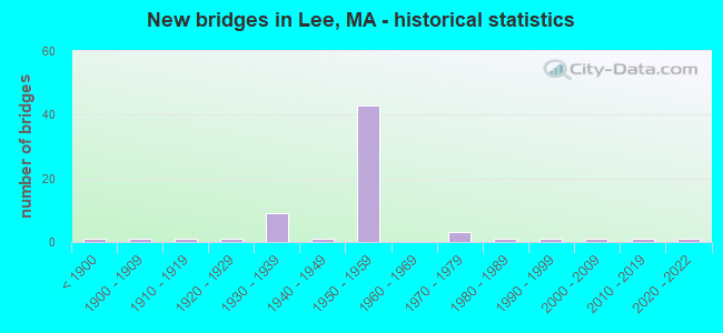
- New bridges - historical statistics
- 1Before 1900
- 11900-1909
- 11910-1919
- 11920-1929
- 91930-1939
- 11940-1949
- 431950-1959
- 31970-1979
- 11980-1989
- 11990-1999
- 12000-2009
- 12010-2019
- 12020-2022

- Reconstructed bridges - Historical Statistics
- 11920-1929
- 11930-1939
- 01940-1949
- 11950-1959
- 11960-1969
- 01970-1979
- 171980-1989
- 51990-1999
- 02000-2009
- 12010-2019


- Bridge Condition - Deck
- 2.4%Excellent
- 4.9%Very good
- 56.1%Good
- 22.0%Satisfactory
- 12.2%Fair
- 2.4%Serious

- Bridge Condition - Superstructure
- 2.4%Excellent
- 7.3%Very good
- 26.8%Good
- 36.6%Satisfactory
- 17.1%Fair
- 9.8%Poor

- Bridge Condition - Substructure
- 2.4%Excellent
- 2.4%Very good
- 43.9%Good
- 34.1%Satisfactory
- 17.1%Fair

- Bridge Condition - Channel
- 3.8%Excellent
- 7.7%Very good
- 42.3%Good
- 26.9%Satisfactory
- 11.5%Fair
- 3.8%Poor
- 3.8%Serious

- Bridge Condition - Culverts
- 33.3%Good
- 66.7%Satisfactory
Find on map >> Show street view
Structure Number: L050494GEDOTNBI, Location: .7 MI W. MAPLE ST A16 (Lat: 42.298642, Lng: -73.234981), Route carried "on" structure: Interstate 90, Year Built: 1957, Year Reconstructed: 1991, Status: Open, Structure Length: 3.91m (12.83ft), Average Daily Traffic: 12,181 (year 2010), Truck Traffic: 22%, Average Future Daily Traffic: 31,902 (year 2031), Design Load: HS 20+Mod, Features Intersected: I 90 RAMPS INT 2
Minimum Vertical Clearance: 30+ m (98+ ft), Kilometerpoint: 17.059, Lanes on structure: 4, Lanes under structure: 2, Base Highway Network: Yes, Toll: On toll road, Owner: State Highway Agency, Approaching Roadway Width: 17.5m (57.4ft), Material/Design: Steel, Design/Construction: Stringer/Multi-beam, Number Of Spans In Main Unit: 3, Length of Maximum Span: 17.2m (56.4ft), Curb-To-Curb Width: 17.5m (57.4ft), Out-to-Out Width: 19.3m (63.3ft)
Condition: Deck: Satisfactory, Superstructure: Satisfactory, Substructure: Fair, Operating Rating: 55.3 metric tons, Method Used To Determine Operating Rating: Load Factor (LF), Inventory Rating: 33.1 metric tons, Method Used To Determine Inventory Rating: Load Factor (LF), Structural Evaluation: Somewhat better than minimum adequacy, Deck Geometry: Meets minimum limits, Underclear: High priority of corrective action, Approach Roadway Alignment: Equal to present desirable criteria, Length Of Structure Improvement: 4.00m (13.12ft), Designated Inspection Frequency: Every 24 months, Inspection Date: April 2020, Bridge Improvement Cost: $3,033,000, Roadway Improvement Cost: $304,000, Total Project Cost: $4,550,000 ( Estimate for 2022), Deck Structure Type: Concrete Cast-file-Place, Wearing Surface/Protective System: Wearing Surface: Bituminous, Membrane: Built-up, Deck Protection: Epoxy Coated Reinforcing
Find on map >> Show street view
Structure Number: L050504GCDOTNBI, Location: .2 MI N. OF RTE 102 A17 (Lat: 42.299903, Lng: -73.222872), Route carried "on" structure: City street , Year Built: 1957, Year Reconstructed: 1994, Status: Open, Structure Length: 6.13m (20.11ft), Average Daily Traffic: 1,025 (year 2018), Truck Traffic: 6%, Average Future Daily Traffic: 3,474 (year 2031), Design Load: HS 20, Features Intersected: I 90, Facility Carried by Structure: HWY MAPLE ST
Minimum Vertical Clearance: 30+ m (98+ ft), Kilometerpoint: 18.024, Lanes on structure: 2, Lanes under structure: 4, Owner: State Highway Agency, Approaching Roadway Width: 7.3m (24.0ft), Skew: 2 degrees, Material/Design: Steel, Design/Construction: Stringer/Multi-beam, Number Of Spans In Main Unit: 4, Length of Maximum Span: 16.3m (53.5ft), Curb or Sidewalk Widths: Left: 1.2m (3.9ft), Right: 1.2m (3.9ft), Curb-To-Curb Width: 7.3m (24.0ft), Out-to-Out Width: 10.7m (35.1ft)
Condition: Deck: Good, Superstructure: Satisfactory, Substructure: Good, Operating Rating: 64.5 metric tons, Method Used To Determine Operating Rating: Load Factor (LF), Inventory Rating: 38.6 metric tons, Method Used To Determine Inventory Rating: Load Factor (LF), Structural Evaluation: Equal to present minimum criteria, Deck Geometry: Meets minimum limits, Underclear: High priority of corrective action, Approach Roadway Alignment: Equal to present desirable criteria, Length Of Structure Improvement: 6.20m (20.34ft), Designated Inspection Frequency: Every 24 months, Inspection Date: April 2020, Bridge Improvement Cost: $3,566,000, Roadway Improvement Cost: $357,000, Total Project Cost: $5,350,000 ( Estimate for 2022), Deck Structure Type: Concrete Cast-file-Place, Wearing Surface/Protective System: Wearing Surface: Bituminous, Deck Protection: Epoxy Coated Reinforcing
Find on map >> Show street view
Structure Number: L050514GADOTNBI, Location: .1 MI N. RTE 20 A18 (Lat: 42.300825, Lng: -73.203683), Route carried "on" structure: Interstate 90, Year Built: 1957, Year Reconstructed: 1993, Status: Open, Structure Length: 3.48m (11.42ft), Average Daily Traffic: 12,308 (year 2017), Truck Traffic: 22%, Average Future Daily Traffic: 31,902 (year 2031), Design Load: HS 20, Features Intersected: HWY CHESTNUT ST
Minimum Vertical Clearance: 30+ m (98+ ft), Kilometerpoint: 19.633, Lanes on structure: 2, Lanes under structure: 2, Base Highway Network: Yes, Toll: On toll road, Owner: State Highway Agency, Approaching Roadway Width: 12.8m (42.0ft), Skew: 2 degrees, Material/Design: Steel, Design/Construction: Stringer/Multi-beam, Number Of Spans In Main Unit: 3, Length of Maximum Span: 11.3m (37.1ft), Curb-To-Curb Width: 12.8m (42.0ft), Out-to-Out Width: 13.7m (44.9ft)
Condition: Deck: Good, Superstructure: Good, Substructure: Satisfactory, Operating Rating: 59.8 metric tons, Method Used To Determine Operating Rating: Load Factor (LF), Inventory Rating: 35.8 metric tons, Method Used To Determine Inventory Rating: Load Factor (LF), Structural Evaluation: Equal to present minimum criteria, Deck Geometry: Equal to present desirable criteria, Underclear: High priority of corrective action, Approach Roadway Alignment: Equal to present desirable criteria, Length Of Structure Improvement: 3.50m (11.48ft), Designated Inspection Frequency: Every 24 months, Inspection Date: April 2020, Bridge Improvement Cost: $377,000, Roadway Improvement Cost: $38,000, Total Project Cost: $566,000 ( Estimate for 2022), Deck Structure Type: Concrete Cast-file-Place, Wearing Surface/Protective System: Wearing Surface: Bituminous, Membrane: Preformed Fabric, Deck Protection: Epoxy Coated Reinforcing
Find on map >> Show street view
Structure Number: L050514GBDOTNBI, Location: .1 MI N. RTE 20 A18 (Lat: 42.301142, Lng: -73.203506), Route carried "on" structure: Interstate 90, Year Built: 1957, Year Reconstructed: 1993, Status: Open, Structure Length: 3.48m (11.42ft), Average Daily Traffic: 12,181 (year 2017), Truck Traffic: 22%, Average Future Daily Traffic: 31,902 (year 2031), Design Load: HS 20, Features Intersected: HWY CHESTNUT ST
Minimum Vertical Clearance: 30+ m (98+ ft), Kilometerpoint: 19.633, Lanes on structure: 2, Lanes under structure: 2, Base Highway Network: Yes, Toll: On toll road, Owner: State Highway Agency, Approaching Roadway Width: 12.8m (42.0ft), Skew: 2 degrees, Material/Design: Steel, Design/Construction: Stringer/Multi-beam, Number Of Spans In Main Unit: 3, Length of Maximum Span: 11.3m (37.1ft), Curb-To-Curb Width: 12.8m (42.0ft), Out-to-Out Width: 13.7m (44.9ft)
Condition: Deck: Good, Superstructure: Good, Substructure: Satisfactory, Operating Rating: 59.7 metric tons, Method Used To Determine Operating Rating: Load Factor (LF), Inventory Rating: 35.8 metric tons, Method Used To Determine Inventory Rating: Load Factor (LF), Structural Evaluation: Equal to present minimum criteria, Deck Geometry: Equal to present desirable criteria, Underclear: Meets minimum limits, Approach Roadway Alignment: Equal to present desirable criteria, Length Of Structure Improvement: 3.50m (11.48ft), Designated Inspection Frequency: Every 24 months, Inspection Date: April 2020, Bridge Improvement Cost: $377,000, Roadway Improvement Cost: $38,000, Total Project Cost: $566,000 ( Estimate for 2022), Deck Structure Type: Concrete Cast-file-Place, Wearing Surface/Protective System: Wearing Surface: Bituminous, Membrane: Preformed Fabric, Deck Protection: Epoxy Coated Reinforcing
Find on map >> Show street view
Structure Number: L050524G8DOTNBI, Location: 1 MI W. OF BECKET RD A19 (Lat: 42.296556, Lng: -73.184758), Route carried "on" structure: US 20, Year Built: 1957, Year Reconstructed: 1994, Status: Open, Structure Length: 9.97m (32.71ft), Average Daily Traffic: 13,836 (year 2010), Truck Traffic: 7%, Average Future Daily Traffic: 8,546 (year 2031), Design Load: HS 20, Features Intersected: I 90
Minimum Vertical Clearance: 30+ m (98+ ft), Kilometerpoint: 21.404, Lanes on structure: 2, Lanes under structure: 4, Base Highway Network: Yes, Toll: On toll road, Owner: State Highway Agency, Approaching Roadway Width: 13.4m (44.0ft), Skew: 5 degrees, Material/Design: Steel continuous, Design/Construction: Stringer/Multi-beam, Number Of Spans In Main Unit: 4, Length of Maximum Span: 29.6m (97.1ft), Curb or Sidewalk Widths: Left: 1.2m (3.9ft), Right: 1.2m (3.9ft), Curb-To-Curb Width: 13.4m (44.0ft), Out-to-Out Width: 16.8m (55.1ft)
Condition: Deck: Satisfactory, Superstructure: Good, Substructure: Satisfactory, Operating Rating: 63.9 metric tons, Method Used To Determine Operating Rating: Load Factor (LF), Inventory Rating: 38.2 metric tons, Method Used To Determine Inventory Rating: Load Factor (LF), Structural Evaluation: Equal to present minimum criteria, Deck Geometry: Equal to present minimum criteria, Underclear: High priority of corrective action, Approach Roadway Alignment: Equal to present desirable criteria, Length Of Structure Improvement: 10.00m (32.81ft), Designated Inspection Frequency: Every 24 months, Inspection Date: April 2020, Bridge Improvement Cost: $1,320,000, Roadway Improvement Cost: $133,000, Total Project Cost: $1,981,000 ( Estimate for 2022), Deck Structure Type: Concrete Cast-file-Place, Wearing Surface/Protective System: Wearing Surface: Bituminous, Membrane: Preformed Fabric, Deck Protection: Epoxy Coated Reinforcing
Find on map >> Show street view
Structure Number: L050534G9DOTNBI, Location: .2MI.E.CHESTNUT ST (Lat: 42.300706, Lng: -73.199075), Route carried "on" structure: Interstate 90, Year Built: 1957, Status: Open, Structure Length: 1.08m (3.54ft), Average Daily Traffic: 29,416 (year 2016), Truck Traffic: 22%, Average Future Daily Traffic: 34,133 (year 2032), Design Load: HS 20, Features Intersected: WATER BASIN POND BROOK
Minimum Vertical Clearance: 30+ m (98+ ft), Kilometerpoint: 19.955, Lanes on structure: 4, Base Highway Network: Yes, Toll: On toll road, Owner: State Highway Agency, Approaching Roadway Width: 12.5m (41.0ft), Skew: 3 degrees, Material/Design: Concrete, Design/Construction: Culvert, Number Of Spans In Main Unit: 1, Length of Maximum Span: 10.8m (35.4ft)
Condition: Channel: Serious, Culverts: Satisfactory, Structural Evaluation: Equal to present minimum criteria, Waterway Adequacy: Superior to present desirable criteria, Approach Roadway Alignment: Equal to present desirable criteria, Length Of Structure Improvement: 1.20m (3.94ft), Designated Inspection Frequency: Every 24 months, Inspection Date: November 2021, Bridge Improvement Cost: $1,037,000, Roadway Improvement Cost: $104,000, Total Project Cost: $1,556,000 ( Estimate for 2022)
Find on map >> Show street view
Structure Number: L07004017MUNNBI, Location: AT INT. W/ CRYSTAL STREET (Lat: 42.332778, Lng: -73.246389), Route carried "on" structure: City street , Year Built: 1973, Status: Open, Structure Length: 3.32m (10.89ft), Average Daily Traffic: 2,800 (year 2012), Truck Traffic: 11%, Average Future Daily Traffic: 4,106 (year 2032), Design Load: HS 20, Features Intersected: WATER HOUSATONIC RIVER, Facility Carried by Structure: HWY MILL ST
Minimum Vertical Clearance: 30+ m (98+ ft), Kilometerpoint: 0.000, Lanes on structure: 2, Owner: Town or Township Highway Agency, Approaching Roadway Width: 11.0m (36.1ft), Skew: 1 degrees, Material/Design: Steel, Design/Construction: Stringer/Multi-beam, Number Of Spans In Main Unit: 1, Length of Maximum Span: 32.3m (106.0ft), Curb or Sidewalk Widths: Left: 1.5m (4.9ft), Right: 1.5m (4.9ft), Curb-To-Curb Width: 12.2m (40.0ft), Out-to-Out Width: 16.1m (52.8ft)
Condition: Deck: Fair, Superstructure: Satisfactory, Substructure: Good, Channel: Good, Operating Rating: 57.4 metric tons, Method Used To Determine Operating Rating: Load Factor (LF), Inventory Rating: 34.4 metric tons, Method Used To Determine Inventory Rating: Load Factor (LF), Structural Evaluation: Equal to present minimum criteria, Deck Geometry: Equal to present minimum criteria, Waterway Adequacy: Equal to present desirable criteria, Approach Roadway Alignment: Equal to present desirable criteria, Length Of Structure Improvement: 3.40m (11.15ft), Designated Inspection Frequency: Every 24 months, Inspection Date: October 2021, Bridge Improvement Cost: $2,105,000, Roadway Improvement Cost: $211,000, Total Project Cost: $3,158,000 ( Estimate for 2022), Deck Structure Type: Concrete Cast-file-Place, Wearing Surface/Protective System: Wearing Surface: Bituminous, Membrane: Built-up
Find on map >> Show street view
Structure Number: L07005AWADOT634, Location: 100' N INT W/ WILLW 77.57 (Lat: 42.331797, Lng: -73.245703), Route carried "on" structure: City street , Year Built: 1998, Status: Open, Structure Length: 3.07m (10.07ft), Average Daily Traffic: 6,724 (year 2014), Truck Traffic: 6%, Average Future Daily Traffic: 4,896 (year 2033), Design Load: HS 20, Features Intersected: RR HRR, Facility Carried by Structure: HWY MILL ST
Minimum Vertical Clearance: 30+ m (98+ ft), Kilometerpoint: 0.000, Lanes on structure: 2, Owner: State Highway Agency, Approaching Roadway Width: 9.8m (32.2ft), Skew: 6 degrees, Material/Design: Steel, Design/Construction: Girder and Floorbeam System, Number Of Spans In Main Unit: 1, Length of Maximum Span: 26.7m (87.6ft), Curb or Sidewalk Widths: Left: 0.0m, Right: 1.5m (4.9ft), Curb-To-Curb Width: 9.8m (32.2ft), Out-to-Out Width: 12.2m (40.0ft)
Condition: Deck: Good, Superstructure: Good, Substructure: Good, Operating Rating: 63.2 metric tons, Method Used To Determine Operating Rating: Load Factor (LF), Inventory Rating: 37.9 metric tons, Method Used To Determine Inventory Rating: Load Factor (LF), Structural Evaluation: Better than present minimum criteria, Deck Geometry: Meets minimum limits, Underclear: High priority of corrective action, Approach Roadway Alignment: Better than present minimum criteria, Length Of Structure Improvement: 3.10m (10.17ft), Designated Inspection Frequency: Every 24 months, Critical Feature Inspection Frequency: Every 24 months, Inspection Date: March 2020, Critical Feature Inspection Date: March 2020, Bridge Improvement Cost: $1,053,000, Roadway Improvement Cost: $106,000, Total Project Cost: $1,580,000 ( Estimate for 2022), Deck Structure Type: Concrete Cast-file-Place, Wearing Surface/Protective System: Wearing Surface: Latex Concrete, Deck Protection: Epoxy Coated Reinforcing
Find on map >> Show street view
Structure Number: L050414GPDOTNBI, Location: .3MI.S.DEVON RD (Lat: 42.297272, Lng: -73.269097), Route carried "under" structure: Interstate 90, Year Built: 1957, Structure Length: 0. m, Average Daily Traffic: 11,858 (year 2018), Truck Traffic: 20%, Features Intersected: I 90 WB, Facility Carried by Structure: HWY STKBRG RD
Minimum Vertical Clearance: 4.66m (15.29ft), Kilometerpoint: 14.162, Lanes on structure: 2, Lanes under structure: 4, Toll: On toll road, Material/Design: Steel, Design/Construction: Stringer/Multi-beam, Length of Maximum Span: 17.4m (57.1ft)
Find on map >> Show street view
Structure Number: L050414GPDOTNBI, Location: 0.3 MI S DEVON RD (Lat: 42.297272, Lng: -73.269097), Route carried "under" structure: Interstate 90, Year Built: 1957, Structure Length: 0. m, Average Daily Traffic: 12,586 (year 2018), Truck Traffic: 20%, Features Intersected: I 90 EB, Facility Carried by Structure: HWY STKBRG RD
Minimum Vertical Clearance: 5.79m (19.00ft), Kilometerpoint: 14.162, Lanes on structure: 2, Lanes under structure: 4, Toll: On toll road, Material/Design: Steel, Design/Construction: Stringer/Multi-beam, Length of Maximum Span: 17.4m (57.1ft)
Find on map >> Show street view
Structure Number: L050424GKDOTNBI, Location: .2 MI E FAIRVIEW ST (Lat: 42.296594, Lng: -73.251786), Route carried "under" structure: City street , Year Built: 1957, Structure Length: 0. m, Features Intersected: COMB QUARRY RD & HRR, Facility Carried by Structure: I 90 EB
Minimum Vertical Clearance: 7.59m (24.90ft), Kilometerpoint: 0.000, Lanes on structure: 2, Lanes under structure: 2, Material/Design: Steel, Design/Construction: Stringer/Multi-beam, Length of Maximum Span: 16.1m (52.8ft)
Find on map >> Show street view
Structure Number: L050424GLDOTNBI, Location: .2 MI E FAIRVIEW ST (Lat: 42.296756, Lng: -73.251803), Route carried "under" structure: City street , Year Built: 1957, Structure Length: 0. m, Features Intersected: COMB QUARRY RD & HRR, Facility Carried by Structure: I 90 WB
Minimum Vertical Clearance: 7.44m (24.41ft), Kilometerpoint: 0.000, Lanes on structure: 2, Lanes under structure: 2, Material/Design: Steel, Design/Construction: Stringer/Multi-beam, Length of Maximum Span: 16.1m (52.8ft)
Find on map >> Show street view
Structure Number: L050434GJDOTNBI, Location: 0.3 MI E FAIRVIEW ST (Lat: 42.297022, Lng: -73.248567), Route carried "under" structure: Interstate 90, Year Built: 1957, Structure Length: 0. m, Average Daily Traffic: 12,220 (year 2016), Truck Traffic: 22%, Features Intersected: I 90 EB, Facility Carried by Structure: HWY MARBLE ST
Minimum Vertical Clearance: 5.70m (18.70ft), Kilometerpoint: 15.932, Lanes on structure: 2, Lanes under structure: 4, Toll: On toll road, Material/Design: Steel, Design/Construction: Stringer/Multi-beam, Length of Maximum Span: 15.8m (51.8ft)
Find on map >> Show street view
Structure Number: L050434GJDOTNBI, Location: .3MI.E.FAIRVIEW ST (Lat: 42.297022, Lng: -73.248567), Route carried "under" structure: Interstate 90, Year Built: 1957, Structure Length: 0. m, Average Daily Traffic: 17,712 (year 2016), Truck Traffic: 22%, Features Intersected: I 90 WB, Facility Carried by Structure: HWY MARBLE ST
Minimum Vertical Clearance: 4.70m (15.42ft), Kilometerpoint: 15.932, Lanes on structure: 2, Lanes under structure: 4, Toll: On toll road, Material/Design: Steel, Design/Construction: Stringer/Multi-beam, Length of Maximum Span: 15.8m (51.8ft)
Find on map >> Show street view
Structure Number: L050444GGDOTNBI, Location: AT INT 2 (Lat: 42.297833, Lng: -73.240656), Route carried "under" structure: US 20, Year Built: 1957, Structure Length: 0. m, Average Daily Traffic: 14,992 (year 2019), Truck Traffic: 12%, Features Intersected: COMB US20 & HOUSATNC R, Facility Carried by Structure: I 90 EB
Minimum Vertical Clearance: 4.54m (14.90ft), Kilometerpoint: 30.057, Lanes on structure: 2, Lanes under structure: 4, Material/Design: Steel, Design/Construction: Stringer/Multi-beam, Length of Maximum Span: 29.1m (95.5ft)
Find on map >> Show street view
Structure Number: L050444GHDOTNBI, Location: AT INT 2 (Lat: 42.297981, Lng: -73.240692), Route carried "under" structure: US 20, Year Built: 1957, Structure Length: 0. m, Average Daily Traffic: 14,992 (year 2019), Truck Traffic: 12%, Features Intersected: COMB US20 & HOUSATNC R, Facility Carried by Structure: I 90 WB
Minimum Vertical Clearance: 4.54m (14.90ft), Kilometerpoint: 30.055, Lanes on structure: 2, Lanes under structure: 4, Material/Design: Steel, Design/Construction: Stringer/Multi-beam, Length of Maximum Span: 29.1m (95.5ft)
Find on map >> Show street view
Structure Number: L050464GQDOTNBI, Location: .2 MI S DEVON RD (Lat: 42.297464, Lng: -73.280214), Route carried "under" structure: City street , Year Built: 1957, Structure Length: 0. m, Average Daily Traffic: 834 (year 2018), Truck Traffic: 10%, Features Intersected: HWY WEST RD, Facility Carried by Structure: I 90 EB
Minimum Vertical Clearance: 4.40m (14.44ft), Kilometerpoint: 0.000, Lanes on structure: 2, Lanes under structure: 2, Material/Design: Steel, Design/Construction: Stringer/Multi-beam, Length of Maximum Span: 10.8m (35.4ft)
Find on map >> Show street view
Structure Number: L050464GRDOTNBI, Location: .2 MI S DEVON RD (Lat: 42.297772, Lng: -73.280197), Route carried "under" structure: City street , Year Built: 1957, Structure Length: 0. m, Average Daily Traffic: 834 (year 2018), Truck Traffic: 10%, Features Intersected: HWY WEST RD, Facility Carried by Structure: I 90 WB
Minimum Vertical Clearance: 4.40m (14.44ft), Kilometerpoint: 0.000, Lanes on structure: 2, Lanes under structure: 2, Material/Design: Steel, Design/Construction: Stringer/Multi-beam, Length of Maximum Span: 10.8m (35.4ft)
Find on map >> Show street view
Structure Number: L050474GMDOTNBI, Location: ATT MM 9.4 (Lat: 42.296053, Lng: -73.257700), Route carried "under" structure: City street , Year Built: 1957, Structure Length: 0. m, Average Daily Traffic: 1,293 (year 2019), Truck Traffic: 3%, Features Intersected: HWY FAIRVIEW ST, Facility Carried by Structure: I 90 EB
Minimum Vertical Clearance: 4.70m (15.42ft), Kilometerpoint: 0.000, Lanes on structure: 2, Lanes under structure: 2, Material/Design: Steel, Design/Construction: Stringer/Multi-beam, Length of Maximum Span: 10.1m (33.1ft)
Find on map >> Show street view
Structure Number: L050474GNDOTNBI, Location: AT MM 9.4 (Lat: 42.296225, Lng: -73.257708), Route carried "under" structure: City street , Year Built: 1957, Structure Length: 0. m, Average Daily Traffic: 1,293 (year 2019), Truck Traffic: 3%, Features Intersected: HWY FAIRVIEW ST, Facility Carried by Structure: I 90 WB
Minimum Vertical Clearance: 4.19m (13.75ft), Kilometerpoint: 0.000, Lanes on structure: 2, Lanes under structure: 2, Material/Design: Steel, Design/Construction: Stringer/Multi-beam, Length of Maximum Span: 10.1m (33.1ft)
Find on map >> Show street view
Structure Number: L050484GFDOTNBI, Location: INT OF RTES 20 & 102 (Lat: 42.296881, Lng: -73.238961), Route carried "under" structure: US 20, Year Built: 1957, Structure Length: 0. m, Average Daily Traffic: 14,992 (year 2019), Truck Traffic: 15%, Features Intersected: US 20 HOUSATONIC ST
Minimum Vertical Clearance: 4.48m (14.70ft), Kilometerpoint: 30.063, Lanes on structure: 2, Lanes under structure: 4, Material/Design: Steel, Design/Construction: Stringer/Multi-beam, Length of Maximum Span: 18.7m (61.4ft)
Find on map >> Show street view
Structure Number: L050494GDDOTNBI, Location: .7MI.W.MAPLE ST (Lat: 42.298483, Lng: -73.234947), Route carried "under" structure: Ramp Interstate 90, Year Built: 1957, Structure Length: 0. m, Average Daily Traffic: 6,567 (year 2018), Truck Traffic: 22%, Features Intersected: I 90 WB RAMP OFF INTR 2
Minimum Vertical Clearance: 5.43m (17.81ft), Kilometerpoint: 17.059, Lanes on structure: 4, Lanes under structure: 2, Toll: On toll road, Material/Design: Steel, Design/Construction: Stringer/Multi-beam, Length of Maximum Span: 17.2m (56.4ft)
Find on map >> Show street view
Structure Number: L050494GEDOTNBI, Location: .7MI.W.MAPLE ST (Lat: 42.298642, Lng: -73.234981), Route carried "under" structure: Ramp Interstate 90, Year Built: 1957, Structure Length: 0. m, Average Daily Traffic: 6,567 (year 2018), Truck Traffic: 22%, Features Intersected: I 90 WB RAMP OFF INTR 2
Minimum Vertical Clearance: 4.70m (15.42ft), Kilometerpoint: 17.059, Lanes on structure: 4, Lanes under structure: 2, Toll: On toll road, Material/Design: Steel, Design/Construction: Stringer/Multi-beam, Length of Maximum Span: 17.2m (56.4ft)
Find on map >> Show street view
Structure Number: L050504GCDOTNBI, Location: 0.1 MI N CHAPEL ST (Lat: 42.299903, Lng: -73.222872), Route carried "under" structure: Interstate 90, Year Built: 1957, Structure Length: 0. m, Average Daily Traffic: 14,608 (year 2018), Truck Traffic: 22%, Features Intersected: I 90 EB, Facility Carried by Structure: HWY MAPLE ST
Minimum Vertical Clearance: 4.45m (14.60ft), Kilometerpoint: 18.024, Lanes on structure: 2, Lanes under structure: 4, Toll: On toll road, Material/Design: Steel, Design/Construction: Stringer/Multi-beam, Length of Maximum Span: 16.3m (53.5ft)
Find on map >> Show street view
Structure Number: L050504GCDOTNBI, Location: .1MI.N.CHAPEL ST (Lat: 42.299903, Lng: -73.222872), Route carried "under" structure: Interstate 90, Year Built: 1957, Structure Length: 0. m, Average Daily Traffic: 15,456 (year 2018), Truck Traffic: 22%, Features Intersected: I 90 WB, Facility Carried by Structure: HWY MAPLE ST
Minimum Vertical Clearance: 4.57m (14.99ft), Kilometerpoint: 18.024, Lanes on structure: 2, Lanes under structure: 4, Toll: On toll road, Material/Design: Steel, Design/Construction: Stringer/Multi-beam, Length of Maximum Span: 16.3m (53.5ft)
Find on map >> Show street view
Structure Number: L050514GADOTNBI, Location: .1 MI N RTE 20 (Lat: 42.300825, Lng: -73.203683), Route carried "under" structure: City street , Year Built: 1957, Structure Length: 0. m, Features Intersected: HWY CHESTNUT ST, Facility Carried by Structure: I 90 EB
Minimum Vertical Clearance: 4.32m (14.17ft), Kilometerpoint: 0.000, Lanes on structure: 2, Lanes under structure: 2, Material/Design: Steel, Design/Construction: Stringer/Multi-beam, Length of Maximum Span: 11.3m (37.1ft)
Find on map >> Show street view
Structure Number: L050514GBDOTNBI, Location: .1 MI N RTE 20 (Lat: 42.301142, Lng: -73.203506), Route carried "under" structure: City street , Year Built: 1957, Structure Length: 0. m, Features Intersected: HWY CHESTNUT ST, Facility Carried by Structure: I 90 WB
Minimum Vertical Clearance: 4.32m (14.17ft), Kilometerpoint: 0.000, Lanes on structure: 2, Lanes under structure: 2, Material/Design: Steel, Design/Construction: Stringer/Multi-beam, Length of Maximum Span: 11.3m (37.1ft)
Find on map >> Show street view
Structure Number: L050524G8DOTNBI, Location: .8MI.W.BECKET RD (Lat: 42.296556, Lng: -73.184758), Route carried "under" structure: Interstate 90, Year Built: 1957, Structure Length: 0. m, Average Daily Traffic: 15,456 (year 2018), Truck Traffic: 22%, Features Intersected: I 90 WB, Facility Carried by Structure: US 20 CAPE ST
Minimum Vertical Clearance: 4.48m (14.70ft), Kilometerpoint: 21.404, Lanes on structure: 2, Lanes under structure: 4, Toll: On toll road, Material/Design: Steel, Design/Construction: Stringer/Multi-beam, Length of Maximum Span: 29.6m (97.1ft)
Find on map >> Show street view
Structure Number: L050524G8DOTNBI, Location: .8MI.W.BECKET RD (Lat: 42.296556, Lng: -73.184758), Route carried "under" structure: Interstate 90, Year Built: 1957, Structure Length: 0. m, Average Daily Traffic: 14,608 (year 2018), Truck Traffic: 22%, Features Intersected: I 90 EB, Facility Carried by Structure: US 20 CAPE ST
Minimum Vertical Clearance: 4.57m (14.99ft), Kilometerpoint: 21.404, Lanes on structure: 2, Lanes under structure: 4, Toll: On toll road, Material/Design: Steel, Design/Construction: Stringer/Multi-beam, Length of Maximum Span: 29.6m (97.1ft)