Bridge Statistics for Lafayette, Tennessee (TN)
Condition, Traffic, Stress, Structural Evaluation, Project Costs
- National Bridge Inventory (NBI) Statistics
- 47Number of bridges
- 249ft / 76.1mTotal length
- $2,979,000Total costs
- 27,581Total average daily traffic
- 1,467Total average daily truck traffic
- 44,129Total future (year 2041) average daily traffic
- National Bridge Inventory (NBI) Registered Bridges for Lafayette
- No street view available for this location
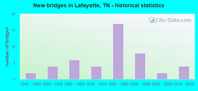
- New bridges - historical statistics
- 21940-1949
- 41950-1959
- 61960-1969
- 41970-1979
- 171980-1989
- 81990-1999
- 22000-2009
- 42010-2019


- Bridge Condition - Deck
- 33.3%Very good
- 33.3%Good
- 33.3%Satisfactory

- Bridge Condition - Superstructure
- 33.3%Very good
- 33.3%Good
- 11.1%Satisfactory
- 22.2%Fair

- Bridge Condition - Substructure
- 33.3%Very good
- 22.2%Good
- 33.3%Satisfactory
- 11.1%Poor

- Bridge Condition - Channel
- 23.4%Very good
- 31.9%Good
- 10.6%Satisfactory
- 25.5%Fair
- 8.5%Poor

- Bridge Condition - Culverts
- 26.3%Very good
- 31.6%Good
- 21.1%Satisfactory
- 13.2%Fair
- 7.9%Poor
Find on map >> Show street view
Structure Number: 56S62890009, Location: 4.75 M SW OF LAFAYETTE (Lat: 36.490217, Lng: -86.101883), Route carried "on" structure: County highway 1082, Year Built: 1945, Status: Open, Structure Length: 0.73m (2.40ft), Average Daily Traffic: 1,142 (year 2020), Truck Traffic: 3%, Average Future Daily Traffic: 1,827 (year 2041), Design Load: H 15, Features Intersected: BARBER'S BRANCH
Minimum Vertical Clearance: 30+ m (98+ ft), Kilometerpoint: 6.502, Lanes on structure: 2, Owner: County Highway Agency, Approaching Roadway Width: 5.8m (19.0ft), Skew: 1 degrees, Material/Design: Steel, Design/Construction: Stringer/Multi-beam, Number Of Spans In Main Unit: 1, Length of Maximum Span: 6.1m (20.0ft), Curb-To-Curb Width: 6.1m (20.0ft), Out-to-Out Width: 7.0m (23.0ft)
Condition: Deck: Satisfactory, Superstructure: Fair, Substructure: Satisfactory, Channel: Satisfactory, Operating Rating: 55.8 metric tons, Method Used To Determine Operating Rating: Allowable Stress (AS), Inventory Rating: 32.4 metric tons, Method Used To Determine Inventory Rating: Allowable Stress (AS), Structural Evaluation: Somewhat better than minimum adequacy, Deck Geometry: High priority of replacement, Waterway Adequacy: Equal to present minimum criteria, Approach Roadway Alignment: Equal to present desirable criteria, Length Of Structure Improvement: 0.73m (2.40ft), Designated Inspection Frequency: Every 24 months, Inspection Date: September 2021, Bridge Improvement Cost: $90,000, Roadway Improvement Cost: $10,000, Total Project Cost: $136,000 ( Estimate for 2021), Deck Structure Type: Concrete Cast-file-Place, Wearing Surface/Protective System: Wearing Surface: Bituminous
Find on map >> Show street view
Structure Number: 56S62890011, Location: 4 M SW OF LAFAYETTE (Lat: 36.489833, Lng: -86.091433), Route carried "on" structure: County highway 1082, Year Built: 1975, Status: Open, Structure Length: 1.16m (3.81ft), Average Daily Traffic: 1,142 (year 2020), Truck Traffic: 3%, Average Future Daily Traffic: 1,827 (year 2041), Design Load: HS 20, Features Intersected: MIDDLE FORK GOOSE CREEK
Minimum Vertical Clearance: 30+ m (98+ ft), Kilometerpoint: 7.451, Lanes on structure: 2, Owner: County Highway Agency, Approaching Roadway Width: 7.0m (23.0ft), Skew: 3 degrees, Material/Design: Concrete continuous, Design/Construction: Culvert, Number Of Spans In Main Unit: 2, Length of Maximum Span: 4.3m (14.1ft), Curb-To-Curb Width: 7.9m (25.9ft), Out-to-Out Width: 8.5m (27.9ft)
Condition: Channel: Fair, Culverts: Satisfactory, Operating Rating: 52.2 metric tons, Method Used To Determine Operating Rating: Load Factor (LF), Inventory Rating: 32.4 metric tons, Method Used To Determine Inventory Rating: Load Factor (LF), Structural Evaluation: Equal to present minimum criteria, Deck Geometry: Meets minimum limits, Waterway Adequacy: Equal to present minimum criteria, Approach Roadway Alignment: Equal to present desirable criteria, Designated Inspection Frequency: Every 24 months, Inspection Date: September 2021, Deck Structure Type: Concrete Cast-file-Place, Wearing Surface/Protective System: Wearing Surface: Bituminous
Find on map >> Show street view
Structure Number: 56SR0100009, Location: 1.28 MI S OF TROUSDALE CO (Lat: 36.504067, Lng: -86.047000), Route carried "on" structure: State highway 10, Year Built: 1974, Status: Open, Structure Length: 0.98m (3.22ft), Average Daily Traffic: 4,263 (year 2020), Truck Traffic: 7%, Average Future Daily Traffic: 6,821 (year 2041), Design Load: HL 93, Features Intersected: E. FK. GOOSE CREEK
Minimum Vertical Clearance: 40.01m (131.27ft), Kilometerpoint: 8.972, Lanes on structure: 2, Base Highway Network: Yes, Owner: State Highway Agency, Approaching Roadway Width: 11.6m (38.1ft), Skew: 4 degrees, Material/Design: Concrete continuous, Design/Construction: Culvert, Number Of Spans In Main Unit: 2, Length of Maximum Span: 7.9m (25.9ft)
Condition: Channel: Very good, Culverts: Very good, Operating Rating: 44.1 metric tons, Method Used To Determine Operating Rating: Assigned rating based on Load Factor Design (LFD) reported in metric tons, Inventory Rating: 32.4 metric tons, Method Used To Determine Inventory Rating: Assigned rating based on Load Factor Design (LFD) reported in metric tons, Structural Evaluation: Equal to present desirable criteria, Waterway Adequacy: Equal to present minimum criteria, Approach Roadway Alignment: Equal to present desirable criteria, Designated Inspection Frequency: Every 24 months, Inspection Date: August 2021
Find on map >> Show street view
Structure Number: 56SR0520009, Location: E OF SR261 NEAR DRAPER RD (Lat: 36.504117, Lng: -85.940367), Route carried "on" structure: State highway 52, Year Built: 1995, Status: Open, Structure Length: 17.10m (56.10ft), Average Daily Traffic: 5,058 (year 2020), Truck Traffic: 11%, Average Future Daily Traffic: 8,093 (year 2042), Design Load: HS 20, Features Intersected: LONG FORK CREEK
Minimum Vertical Clearance: 30+ m (98+ ft), Kilometerpoint: 28.630, Lanes on structure: 2, Base Highway Network: Yes, Owner: State Highway Agency, Approaching Roadway Width: 14.6m (47.9ft), Skew: 1 degrees, Material/Design: Prestressed concrete continuous, Design/Construction: Stringer/Multi-beam, Number Of Spans In Main Unit: 5, Length of Maximum Span: 34.1m (111.9ft), Curb-To-Curb Width: 14.6m (47.9ft), Out-to-Out Width: 15.2m (49.9ft)
Condition: Deck: Very good, Superstructure: Very good, Substructure: Very good, Channel: Very good, Operating Rating: 77.4 metric tons, Method Used To Determine Operating Rating: Load Factor (LF), Inventory Rating: 46.8 metric tons, Method Used To Determine Inventory Rating: Load Factor (LF), Structural Evaluation: Equal to present desirable criteria, Deck Geometry: Superior to present desirable criteria, Waterway Adequacy: Equal to present desirable criteria, Approach Roadway Alignment: Equal to present desirable criteria, Designated Inspection Frequency: Every 24 months, Inspection Date: August 2021, Deck Structure Type: Concrete Cast-file-Place, Wearing Surface/Protective System: Wearing Surface: Monolithic Concrete, Deck Protection: Epoxy Coated Reinforcing