Bridge Statistics for Lafayette, California (CA)
Condition, Traffic, Stress, Structural Evaluation, Project Costs
- National Bridge Inventory (NBI) Statistics
- 62Number of bridges
- 1,030ft / 314mTotal length
- $1,271,000Total costs
- 2,211,665Total average daily traffic
- 58,408Total average daily truck traffic
- National Bridge Inventory (NBI) Registered Bridges for Lafayette
- No street view available for this location
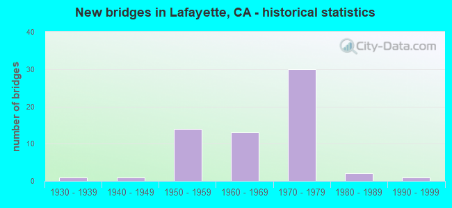
- New bridges - historical statistics
- 11930-1939
- 11940-1949
- 141950-1959
- 131960-1969
- 301970-1979
- 21980-1989
- 11990-1999

- Reconstructed bridges - Historical Statistics
- 11950-1959
- 71960-1969
- 01970-1979
- 01980-1989
- 01990-1999
- 12000-2009


- Bridge Condition - Deck
- 50.0%Good
- 7.5%Satisfactory
- 35.0%Fair
- 7.5%Poor

- Bridge Condition - Superstructure
- 70.0%Good
- 30.0%Fair

- Bridge Condition - Substructure
- 82.5%Good
- 5.0%Satisfactory
- 12.5%Fair

- Bridge Condition - Channel
- 26.7%Very good
- 53.3%Good
- 13.3%Satisfactory
- 6.7%Fair

- Bridge Condition - Culverts
- 50.0%Good
- 50.0%Satisfactory
Find on map >> Show street view
Structure Number: 28C0423, Location: WEST OF CAROL LANE (Lat: 37.889742, Lng: -122.102700), Route carried "on" structure: City street , Year Built: 1970, Status: Open, Structure Length: 3.75m (12.30ft), Average Daily Traffic: 1,590 (year 2008), Truck Traffic: 1%, Average Future Daily Traffic: 930 (year 2042), Features Intersected: LAS TRAMPAS CREEK, Facility Carried by Structure: MORAGA BLVD
Minimum Vertical Clearance: 30+ m (98+ ft), Kilometerpoint: 0.000, Lanes on structure: 2, Owner: City or Municipal Highway Agency, Approaching Roadway Width: 11.0m (36.1ft), Skew: 1 degrees, Material/Design: Steel continuous, Design/Construction: Stringer/Multi-beam, Number Of Spans In Main Unit: 3, Length of Maximum Span: 18.3m (60.0ft), Curb or Sidewalk Widths: Left: 1.2m (3.9ft), Right: 1.2m (3.9ft), Curb-To-Curb Width: 11.0m (36.1ft), Out-to-Out Width: 13.4m (44.0ft)
Condition: Deck: Good, Superstructure: Good, Substructure: Satisfactory, Channel: Satisfactory, Operating Rating: 73.2 metric tons, Method Used To Determine Operating Rating: Load Factor (LF), Inventory Rating: 43.7 metric tons, Method Used To Determine Inventory Rating: Load Factor (LF), Structural Evaluation: Equal to present minimum criteria, Deck Geometry: Equal to present minimum criteria, Waterway Adequacy: Equal to present desirable criteria, Approach Roadway Alignment: Better than present minimum criteria, Designated Inspection Frequency: Every 48 months, Inspection Date: June 2020, Deck Structure Type: Concrete Cast-file-Place
Find on map >> Show street view
Structure Number: 28 0045S, Location: 04-CC-024-R7.60-LFYT (Lat: 37.896783, Lng: -122.097431), Route carried "under" structure: City street , Year Built: 1971, Structure Length: 0. m, Average Daily Traffic: 16,700 (year 2017), Truck Traffic: 1%, Features Intersected: MOUNT DIABLO BOULEVARD, Facility Carried by Structure: E24-PLEASANT HILL
Minimum Vertical Clearance: 5.79m (19.00ft), Kilometerpoint: 0.000, Lanes on structure: 1, Lanes under structure: 4, Material/Design: Concrete continuous, Design/Construction: Box Beam or Girders - Multiple, Length of Maximum Span: 27.4m (89.9ft)
Find on map >> Show street view
Structure Number: 28 0106K, Location: 04-CC-024-R7.66-LFYT (Lat: 37.898008, Lng: -122.096386), Route carried "under" structure: City street , Year Built: 1970, Structure Length: 0. m, Average Daily Traffic: 45,700 (year 2017), Truck Traffic: 1%, Features Intersected: PLEASANT HILL ROAD, Facility Carried by Structure: SR 24 WB RAMP
Minimum Vertical Clearance: 4.52m (14.83ft), Kilometerpoint: 0.000, Lanes on structure: 2, Lanes under structure: 7, Material/Design: Concrete continuous, Design/Construction: Box Beam or Girders - Multiple, Length of Maximum Span: 41.1m (134.8ft)
Find on map >> Show street view
Structure Number: 28 0106L, Location: 04-CC-024-R7.66-LFYT (Lat: 37.897811, Lng: -122.096322), Route carried "under" structure: City street , Year Built: 1970, Structure Length: 0. m, Average Daily Traffic: 45,700 (year 2019), Truck Traffic: 1%, Features Intersected: PLEASANT HILL ROAD, Facility Carried by Structure: SR 24 WB
Minimum Vertical Clearance: 4.93m (16.17ft), Kilometerpoint: 0.000, Lanes on structure: 4, Lanes under structure: 7, Material/Design: Concrete continuous, Design/Construction: Box Beam or Girders - Multiple, Length of Maximum Span: 41.1m (134.8ft)
Find on map >> Show street view
Structure Number: 28 0106R, Location: 04-CC-024-R7.66-LFYT (Lat: 37.897447, Lng: -122.096256), Route carried "under" structure: City street , Year Built: 1971, Structure Length: 0. m, Average Daily Traffic: 45,700 (year 2019), Truck Traffic: 1%, Features Intersected: PLEASANT HILL ROAD, Facility Carried by Structure: SR 24 EB
Minimum Vertical Clearance: 4.97m (16.31ft), Kilometerpoint: 0.000, Lanes on structure: 4, Lanes under structure: 7, Material/Design: Concrete continuous, Design/Construction: Box Beam or Girders - Multiple, Length of Maximum Span: 41.1m (134.8ft)
Find on map >> Show street view
Structure Number: 28 0106S, Location: 04-CC-024-R7.66-LFYT (Lat: 37.897286, Lng: -122.096222), Route carried "under" structure: City street , Year Built: 1971, Structure Length: 0. m, Average Daily Traffic: 45,700 (year 2019), Truck Traffic: 1%, Features Intersected: PLEASANT HILL ROAD, Facility Carried by Structure: SR 24 EB RAMP
Minimum Vertical Clearance: 4.83m (15.85ft), Kilometerpoint: 0.000, Lanes on structure: 2, Lanes under structure: 7, Material/Design: Concrete continuous, Design/Construction: Box Beam or Girders - Multiple, Length of Maximum Span: 41.1m (134.8ft)
Find on map >> Show street view
Structure Number: 28 0110K, Location: 04-CC-024-R4.40-LFYT (Lat: 37.892397, Lng: -122.154667), Route carried "under" structure: City street , Year Built: 1969, Structure Length: 0. m, Average Daily Traffic: 16,700 (year 2018), Truck Traffic: 3%, Features Intersected: ACALANES ROAD, Facility Carried by Structure: STATE ROUTE 24
Minimum Vertical Clearance: 4.95m (16.24ft), Kilometerpoint: 0.000, Lanes on structure: 1, Lanes under structure: 4, Material/Design: Concrete, Design/Construction: Box Beam or Girders - Multiple, Length of Maximum Span: 25.3m (83.0ft)
Find on map >> Show street view
Structure Number: 28 0110L, Location: 04-CC-024-R4.40-LFYT (Lat: 37.892133, Lng: -122.154597), Route carried "under" structure: City street , Year Built: 1969, Structure Length: 0. m, Average Daily Traffic: 16,700 (year 2018), Truck Traffic: 3%, Features Intersected: ACALANES ROAD, Facility Carried by Structure: STATE ROUTE 24 WB
Minimum Vertical Clearance: 5.25m (17.22ft), Kilometerpoint: 0.000, Lanes on structure: 5, Lanes under structure: 4, Material/Design: Concrete, Design/Construction: Box Beam or Girders - Multiple, Length of Maximum Span: 25.3m (83.0ft)
Find on map >> Show street view
Structure Number: 28 0110R, Location: 04-CC-024-R4.40-LFYT (Lat: 37.891747, Lng: -122.154511), Route carried "under" structure: City street , Year Built: 1959, Structure Length: 0. m, Average Daily Traffic: 16,700 (year 2017), Truck Traffic: 3%, Features Intersected: ACALANES ROAD, Facility Carried by Structure: STATE ROUTE 24 EB
Minimum Vertical Clearance: 4.87m (15.98ft), Kilometerpoint: 0.000, Lanes on structure: 4, Lanes under structure: 4, Material/Design: Concrete, Design/Construction: Box Beam or Girders - Multiple, Length of Maximum Span: 25.3m (83.0ft)
Find on map >> Show street view
Structure Number: 28 0110S, Location: 04-CC-024-R4.40-LFYT (Lat: 37.891581, Lng: -122.154469), Route carried "under" structure: City street , Year Built: 1959, Structure Length: 0. m, Average Daily Traffic: 16,700 (year 2017), Truck Traffic: 3%, Features Intersected: ACALANES ROAD, Facility Carried by Structure: E24 & ACALANES RD
Minimum Vertical Clearance: 5.72m (18.77ft), Kilometerpoint: 0.000, Lanes on structure: 2, Lanes under structure: 4, Material/Design: Concrete, Design/Construction: Box Beam or Girders - Multiple, Length of Maximum Span: 25.9m (85.0ft)
Find on map >> Show street view
Structure Number: 28 0125, Location: 04-CC-024-R8.27 (Lat: 37.898519, Lng: -122.085286), Route carried "under" structure: State highway 24, Year Built: 1971, Structure Length: 0. m, Average Daily Traffic: 159,000 (year 2019), Truck Traffic: 3%, Features Intersected: STATE ROUTE 24 & BARTD, Facility Carried by Structure: EL CURTOLA BLVD
Minimum Vertical Clearance: 10.67m (35.01ft), Kilometerpoint: 8.270, Lanes on structure: 2, Lanes under structure: 10, Material/Design: Prestressed concrete continuous, Design/Construction: Box Beam or Girders - Multiple, Length of Maximum Span: 59.1m (193.9ft)
Find on map >> Show street view
Structure Number: 28 0132L, Location: 04-CC-024-R5.97-LFYT (Lat: 37.892869, Lng: -122.126433), Route carried "under" structure: City street , Year Built: 1970, Structure Length: 0. m, Average Daily Traffic: 11,400 (year 2019), Truck Traffic: 1%, Features Intersected: HAPPY VALLEY ROAD, Facility Carried by Structure: STATE ROUTE 24
Minimum Vertical Clearance: 8.18m (26.84ft), Kilometerpoint: 0.000, Lanes on structure: 4, Lanes under structure: 2, Material/Design: Concrete continuous, Design/Construction: Box Beam or Girders - Multiple, Length of Maximum Span: 19.5m (64.0ft)
Find on map >> Show street view
Structure Number: 28 0132R, Location: 04-CC-024-R5.97-LFYT (Lat: 37.892453, Lng: -122.126353), Route carried "under" structure: City street , Year Built: 1957, Structure Length: 0. m, Average Daily Traffic: 11,400 (year 2019), Truck Traffic: 1%, Features Intersected: HAPPY VALLEY ROAD, Facility Carried by Structure: STATE ROUTE 24
Minimum Vertical Clearance: 8.33m (27.33ft), Kilometerpoint: 0.000, Lanes on structure: 4, Lanes under structure: 2, Material/Design: Concrete continuous, Design/Construction: Tee Beam, Length of Maximum Span: 19.5m (64.0ft)
Find on map >> Show street view
Structure Number: 28 0133L, Location: 04-CC-024-R6.26-LFYT (Lat: 37.893994, Lng: -122.121650), Route carried "under" structure: Business City street , Year Built: 1970, Structure Length: 0. m, Average Daily Traffic: 11,400 (year 2019), Truck Traffic: 1%, Features Intersected: OAK HILL ROAD, Facility Carried by Structure: STATE ROUTE 24
Minimum Vertical Clearance: 4.54m (14.90ft), Kilometerpoint: 0.000, Lanes on structure: 4, Lanes under structure: 4, Material/Design: Concrete continuous, Design/Construction: Box Beam or Girders - Multiple, Length of Maximum Span: 33.5m (109.9ft)
Find on map >> Show street view
Structure Number: 28 0133R, Location: 04-CC-024-R6.26-LFYT (Lat: 37.893639, Lng: -122.121253), Route carried "under" structure: Business City street , Year Built: 1971, Structure Length: 0. m, Average Daily Traffic: 11,400 (year 2017), Truck Traffic: 1%, Features Intersected: OAK HILL ROAD, Facility Carried by Structure: STATE ROUTE 24
Minimum Vertical Clearance: 4.70m (15.42ft), Kilometerpoint: 0.000, Lanes on structure: 4, Lanes under structure: 4, Material/Design: Concrete continuous, Design/Construction: Box Beam or Girders - Multiple, Length of Maximum Span: 31.3m (102.7ft)
Find on map >> Show street view
Structure Number: 28 0137L, Location: 04-CC-024-R4.90-LFYT (Lat: 37.891369, Lng: -122.146083), Route carried "under" structure: City street , Year Built: 1969, Structure Length: 0. m, Average Daily Traffic: 3,870 (year 2002), Truck Traffic: 1%, Features Intersected: EL NIDO RANCH RD,AQUEDUC, Facility Carried by Structure: STATE ROUTE 24
Minimum Vertical Clearance: 6.02m (19.75ft), Kilometerpoint: 0.000, Lanes on structure: 4, Lanes under structure: 2, Material/Design: Concrete continuous, Design/Construction: Box Beam or Girders - Multiple, Length of Maximum Span: 30.5m (100.1ft)
Find on map >> Show street view
Structure Number: 28 0137R, Location: 04-CC-024-R4.90-LFYT (Lat: 37.890869, Lng: -122.145339), Route carried "under" structure: City street , Year Built: 1957, Structure Length: 0. m, Average Daily Traffic: 3,870 (year 2017), Truck Traffic: 1%, Features Intersected: EL NIDO RANCH RD, Facility Carried by Structure: STATE ROUTE 24
Minimum Vertical Clearance: 5.05m (16.57ft), Kilometerpoint: 0.000, Lanes on structure: 4, Lanes under structure: 2, Material/Design: Concrete continuous, Design/Construction: Box Beam or Girders - Multiple, Length of Maximum Span: 33.5m (109.9ft)
Find on map >> Show street view
Structure Number: 28 0228K, Location: 04-CC-024-R6.51-LFYT (Lat: 37.895006, Lng: -122.116878), Route carried "under" structure: City street , Year Built: 1970, Structure Length: 0. m, Average Daily Traffic: 1,200 (year 2019), Truck Traffic: 1%, Features Intersected: FIRST STREET, Facility Carried by Structure: STATE ROUTE 24
Minimum Vertical Clearance: 5.05m (16.57ft), Kilometerpoint: 0.000, Lanes on structure: 1, Lanes under structure: 4, Material/Design: Prestressed concrete, Design/Construction: Box Beam or Girders - Multiple, Length of Maximum Span: 39.0m (128.0ft)
Find on map >> Show street view
Structure Number: 28 0228L, Location: 04-CC-024-R6.51-LFYT (Lat: 37.894775, Lng: -122.116856), Route carried "under" structure: City street , Year Built: 1970, Structure Length: 0. m, Average Daily Traffic: 1,200 (year 2019), Truck Traffic: 1%, Features Intersected: FIRST STREET, Facility Carried by Structure: STATE ROUTE 24
Minimum Vertical Clearance: 4.90m (16.08ft), Kilometerpoint: 0.000, Lanes on structure: 4, Lanes under structure: 4, Material/Design: Prestressed concrete, Design/Construction: Box Beam or Girders - Multiple, Length of Maximum Span: 39.0m (128.0ft)
Find on map >> Show street view
Structure Number: 28 0228R, Location: 04-CC-024-R6.51-LFYT (Lat: 37.894367, Lng: -122.116814), Route carried "under" structure: City street , Year Built: 1971, Structure Length: 0. m, Average Daily Traffic: 1,200 (year 2019), Truck Traffic: 1%, Features Intersected: FIRST STREET, Facility Carried by Structure: STATE ROUTE 24
Minimum Vertical Clearance: 4.80m (15.75ft), Kilometerpoint: 0.000, Lanes on structure: 4, Lanes under structure: 4, Material/Design: Prestressed concrete, Design/Construction: Box Beam or Girders - Multiple, Length of Maximum Span: 39.0m (128.0ft)
Find on map >> Show street view
Structure Number: 28C0154, Location: 0.6 MI E OF GEARY ROAD (Lat: 37.921458, Lng: -122.097128), Route carried "under" structure: County highway , Year Built: 1956, Structure Length: 0. m, Average Daily Traffic: 5,000 (year 1998), Truck Traffic: 1%, Features Intersected: TAYLOR BLVD, Facility Carried by Structure: PLEASANT HILL RD
Minimum Vertical Clearance: 4.47m (14.67ft), Kilometerpoint: 0.000, Lanes on structure: 2, Lanes under structure: 2, Material/Design: Prestressed concrete, Design/Construction: Stringer/Multi-beam, Length of Maximum Span: 18.3m (60.0ft)