Bridge Statistics for Jenks, Oklahoma (OK)
Condition, Traffic, Stress, Structural Evaluation, Project Costs
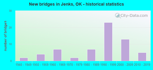
- New bridges - historical statistics
- 21940-1949
- 41950-1959
- 71960-1969
- 21970-1979
- 71980-1989
- 231990-1999
- 132000-2009
- 52010-2019

- Reconstructed bridges - Historical Statistics
- 11950-1959
- 01960-1969
- 11970-1979
- 01980-1989
- 11990-1999
- 22000-2009
- 12010-2019


- Bridge Condition - Deck
- 2.7%Very good
- 75.7%Good
- 18.9%Satisfactory
- 2.7%Fair

- Bridge Condition - Superstructure
- 45.9%Very good
- 32.4%Good
- 10.8%Satisfactory
- 10.8%Fair

- Bridge Condition - Substructure
- 5.4%Very good
- 70.3%Good
- 5.4%Satisfactory
- 16.2%Fair
- 2.7%Poor

- Bridge Condition - Channel
- 6.5%Excellent
- 29.0%Very good
- 38.7%Good
- 6.5%Satisfactory
- 19.4%Fair

- Bridge Condition - Culverts
- 33.3%Very good
- 55.6%Good
- 11.1%Satisfactory
Find on map >> Show street view
Structure Number: 2604, Location: 04.87N (Lat: 36.010036, Lng: -96.012350), Route carried "on" structure: Other road , Year Built: 2000, Status: Open, Structure Length: 10.53m (34.55ft), Average Daily Traffic: 11,200 (year 2020), Truck Traffic: 25%, Average Future Daily Traffic: 17,920 (year 2040), Design Load: HS 20, Features Intersected: U.S. 75 UNDER, Facility Carried by Structure: CREEK TP
Minimum Vertical Clearance: 30+ m (98+ ft), Kilometerpoint: 1.561, Lanes on structure: 3, Lanes under structure: 6, Base Highway Network: Yes, Toll: On toll road, Owner: State Toll Authority, Approaching Roadway Width: 15.5m (50.9ft), Skew: 10 degrees, Material/Design: Prestressed concrete, Design/Construction: Stringer/Multi-beam, Number Of Spans In Main Unit: 5, Length of Maximum Span: 24.4m (80.1ft), Curb-To-Curb Width: 20.0m (65.6ft), Out-to-Out Width: 20.9m (68.6ft)
Condition: Deck: Good, Superstructure: Very good, Substructure: Good, Operating Rating: 44.5 metric tons, Method Used To Determine Operating Rating: Load Factor (LF), Inventory Rating: 32.7 metric tons, Method Used To Determine Inventory Rating: Load Factor (LF), Structural Evaluation: Better than present minimum criteria, Deck Geometry: Superior to present desirable criteria, Underclear: Meets minimum limits, Approach Roadway Alignment: Equal to present minimum criteria, Length Of Structure Improvement: 10.53m (34.55ft), Designated Inspection Frequency: Every 24 months, Inspection Date: August 2020, Bridge Improvement Cost: $1,316,000, Roadway Improvement Cost: $1,875,000, Total Project Cost: $3,637,000 ( Estimate for 2015), Deck Structure Type: Concrete Cast-file-Place, Wearing Surface/Protective System: Wearing Surface: Monolithic Concrete
Find on map >> Show street view
Structure Number: 26041, Location: 04.87S (Lat: 36.009667, Lng: -96.012353), Route carried "on" structure: Other road , Year Built: 2000, Status: Open, Structure Length: 10.51m (34.48ft), Average Daily Traffic: 10,850 (year 2020), Truck Traffic: 8%, Average Future Daily Traffic: 17,360 (year 2040), Design Load: HS 20, Features Intersected: U.S. 75 UNDER, Facility Carried by Structure: CREEK TP
Minimum Vertical Clearance: 30+ m (98+ ft), Kilometerpoint: 1.561, Lanes on structure: 3, Lanes under structure: 6, Base Highway Network: Yes, Toll: On toll road, Owner: State Toll Authority, Approaching Roadway Width: 15.5m (50.9ft), Skew: 20 degrees, Material/Design: Prestressed concrete, Design/Construction: Stringer/Multi-beam, Number Of Spans In Main Unit: 5, Length of Maximum Span: 24.4m (80.1ft), Curb-To-Curb Width: 20.0m (65.6ft), Out-to-Out Width: 20.9m (68.6ft)
Condition: Deck: Good, Superstructure: Very good, Substructure: Good, Operating Rating: 44.5 metric tons, Method Used To Determine Operating Rating: Allowable Stress (AS), Inventory Rating: 32.7 metric tons, Method Used To Determine Inventory Rating: Allowable Stress (AS), Structural Evaluation: Better than present minimum criteria, Deck Geometry: Superior to present desirable criteria, Underclear: Meets minimum limits, Approach Roadway Alignment: Equal to present minimum criteria, Length Of Structure Improvement: 10.51m (34.48ft), Designated Inspection Frequency: Every 24 months, Inspection Date: August 2020, Bridge Improvement Cost: $1,618,000, Roadway Improvement Cost: $1,875,000, Total Project Cost: $3,980,000 ( Estimate for 2015), Deck Structure Type: Concrete Cast-file-Place, Wearing Surface/Protective System: Wearing Surface: Monolithic Concrete, Deck Protection: Epoxy Coated Reinforcing
Find on map >> Show street view
Structure Number: 26112, Location: 0.2 S. OF 101ST. SOUTH (Lat: 36.015628, Lng: -96.029586), Route carried "on" structure: County highway N3920, Year Built: 2001, Status: Open, Structure Length: 7.69m (25.23ft), Average Daily Traffic: 700 (year 2020), Truck Traffic: 15%, Average Future Daily Traffic: 1,120 (year 2040), Design Load: HS 20, Features Intersected: POLECAT CREEK
Minimum Vertical Clearance: 30+ m (98+ ft), Kilometerpoint: 3.058, Lanes on structure: 2, Owner: County Highway Agency, Approaching Roadway Width: 10.0m (32.8ft), Skew: 3 degrees, Material/Design: Prestressed concrete, Design/Construction: Stringer/Multi-beam, Number Of Spans In Main Unit: 3, Length of Maximum Span: 31.7m (104.0ft), Curb-To-Curb Width: 10.2m (33.5ft), Out-to-Out Width: 11.0m (36.1ft)
Condition: Deck: Good, Superstructure: Very good, Substructure: Very good, Channel: Good, Operating Rating: 44.5 metric tons, Method Used To Determine Operating Rating: Allowable Stress (AS), Inventory Rating: 32.7 metric tons, Method Used To Determine Inventory Rating: Allowable Stress (AS), Structural Evaluation: Equal to present desirable criteria, Deck Geometry: Equal to present minimum criteria, Waterway Adequacy: Better than present minimum criteria, Approach Roadway Alignment: Better than present minimum criteria, Length Of Structure Improvement: 10.17m (33.37ft), Designated Inspection Frequency: Every 24 months, Inspection Date: September 2021, Bridge Improvement Cost: $519,000, Roadway Improvement Cost: $286,000, Total Project Cost: $811,000 ( Estimate for 2015), Deck Structure Type: Concrete Cast-file-Place, Wearing Surface/Protective System: Wearing Surface: Monolithic Concrete, Deck Protection: Epoxy Coated Reinforcing
Find on map >> Show street view
Structure Number: 29017, Location: MAIN ST. OVER HAGER CREEK (Lat: 36.024444, Lng: -95.998056), Route carried "on" structure: City street E0685, Year Built: 2011, Status: Open, Structure Length: 0.98m (3.22ft), Average Daily Traffic: 10,000 (year 2020), Truck Traffic: 5%, Average Future Daily Traffic: 23,200 (year 2040), Design Load: HS 20, Features Intersected: HAGER CREEK, Facility Carried by Structure: MAIN ST.(96TH ST)
Minimum Vertical Clearance: 30+ m (98+ ft), Kilometerpoint: 1.287, Lanes on structure: 2, Owner: City or Municipal Highway Agency, Maintenance Responsibility: County Highway Agency, Approaching Roadway Width: 15.2m (49.9ft), Material/Design: Concrete, Design/Construction: Culvert, Number Of Spans In Main Unit: 3, Length of Maximum Span: 3.0m (9.8ft), Curb or Sidewalk Widths: Left: 2.1m (6.9ft), Right: 2.1m (6.9ft), Curb-To-Curb Width: 31.1m (102.0ft), Out-to-Out Width: 31.7m (104.0ft)
Condition: Channel: Very good, Culverts: Good, Operating Rating: 44.5 metric tons, Method Used To Determine Operating Rating: Allowable Stress (AS), Inventory Rating: 32.7 metric tons, Method Used To Determine Inventory Rating: Allowable Stress (AS), Structural Evaluation: Better than present minimum criteria, Deck Geometry: Superior to present desirable criteria, Waterway Adequacy: Equal to present desirable criteria, Approach Roadway Alignment: Equal to present desirable criteria, Length Of Structure Improvement: 1.01m (3.31ft), Designated Inspection Frequency: Every 24 months, Inspection Date: Febuary 2020, Bridge Improvement Cost: $225,000, Roadway Improvement Cost: $50,000, Total Project Cost: $300,000 ( Estimate for 2015)
Find on map >> Show street view
Structure Number: 29126, Location: .3 N. OF CREEK TPK (Lat: 36.019831, Lng: -95.974614), Route carried "on" structure: City street E0690, Year Built: 2007, Status: Open, Structure Length: 0.87m (2.85ft), Average Daily Traffic: 200 (year 2020), Truck Traffic: 10%, Average Future Daily Traffic: 320 (year 2040), Design Load: H 20, Features Intersected: CREEK, Facility Carried by Structure: VETERANS DR.
Minimum Vertical Clearance: 30+ m (98+ ft), Kilometerpoint: 0.483, Lanes on structure: 2, Owner: City or Municipal Highway Agency, Maintenance Responsibility: County Highway Agency, Approaching Roadway Width: 8.6m (28.2ft), Skew: 3 degrees, Material/Design: Concrete, Design/Construction: Culvert, Number Of Spans In Main Unit: 7, Length of Maximum Span: 0.8m (2.6ft), Curb-To-Curb Width: 7.7m (25.3ft), Out-to-Out Width: 8.6m (28.2ft)
Condition: Channel: Excellent, Culverts: Good, Operating Rating: 44.5 metric tons, Method Used To Determine Operating Rating: Allowable Stress (AS), Inventory Rating: 32.7 metric tons, Method Used To Determine Inventory Rating: Allowable Stress (AS), Structural Evaluation: Better than present minimum criteria, Deck Geometry: Somewhat better than minimum adequacy, Waterway Adequacy: Equal to present minimum criteria, Approach Roadway Alignment: Equal to present desirable criteria, Length Of Structure Improvement: 0.96m (3.15ft), Designated Inspection Frequency: Every 24 months, Inspection Date: Febuary 2020, Bridge Improvement Cost: $225,000, Roadway Improvement Cost: $50,000, Total Project Cost: $300,000 ( Estimate for 2015)
Find on map >> Show street view
Structure Number: 29136, Location: 4N OF JCT S.H. 67 (Lat: 36.002867, Lng: -96.011067), Route carried "on" structure: City street , Year Built: 2010, Status: Open, Structure Length: 11.72m (38.45ft), Average Daily Traffic: 5,000 (year 2020), Truck Traffic: 15%, Average Future Daily Traffic: 8,000 (year 2040), Design Load: HL 93, Features Intersected: U.S. 75 UNDER, Facility Carried by Structure: W. 111TH STREET
Minimum Vertical Clearance: 30+ m (98+ ft), Kilometerpoint: 6.436, Lanes on structure: 4, Lanes under structure: 6, Owner: State Highway Agency, Approaching Roadway Width: 20.1m (65.9ft), Skew: 20 degrees, Material/Design: Prestressed concrete, Design/Construction: Stringer/Multi-beam, Number Of Spans In Main Unit: 5, Length of Maximum Span: 28.0m (91.9ft), Curb or Sidewalk Widths: Left: 2.4m (7.9ft), Right: 2.4m (7.9ft), Curb-To-Curb Width: 20.1m (65.9ft), Out-to-Out Width: 25.9m (85.0ft)
Condition: Deck: Good, Superstructure: Good, Substructure: Good, Operating Rating: 64.9 metric tons, Method Used To Determine Operating Rating: Load and Resistance Factor (LRFR), Inventory Rating: 47.3 metric tons, Method Used To Determine Inventory Rating: Load and Resistance Factor (LRFR), Structural Evaluation: Better than present minimum criteria, Deck Geometry: Better than present minimum criteria, Underclear: Somewhat better than minimum adequacy, Approach Roadway Alignment: Equal to present desirable criteria, Length Of Structure Improvement: 12.89m (42.29ft), Designated Inspection Frequency: Every 24 months, Inspection Date: December 2020, Bridge Improvement Cost: $777,000, Roadway Improvement Cost: $1,333,000, Total Project Cost: $2,222,000 ( Estimate for 2015), Deck Structure Type: Concrete Cast-file-Place, Wearing Surface/Protective System: Wearing Surface: Monolithic Concrete, Membrane: Epoxy, Deck Protection: Epoxy Coated Reinforcing
Find on map >> Show street view
Structure Number: 29443, Location: 3.4N S.H. 67 (Lat: 35.992928, Lng: -96.012139), Route carried "on" structure: ServiceUS 75, Year Built: 2010, Status: Open, Structure Length: 0.70m (2.30ft), Average Daily Traffic: 1,000 (year 2020), Truck Traffic: 14%, Average Future Daily Traffic: 1,600 (year 2040), Design Load: HL 93, Features Intersected: TRIBUTARY
Minimum Vertical Clearance: 30+ m (98+ ft), Kilometerpoint: 5.472, Lanes on structure: 2, Owner: State Highway Agency, Approaching Roadway Width: 8.5m (27.9ft), Material/Design: Concrete, Design/Construction: Culvert, Number Of Spans In Main Unit: 2, Length of Maximum Span: 3.0m (9.8ft)
Condition: Channel: Very good, Culverts: Very good, Operating Rating: 39.1 metric tons, Method Used To Determine Operating Rating: Load and Resistance Factor (LRFR), Inventory Rating: 32.7 metric tons, Method Used To Determine Inventory Rating: Load and Resistance Factor (LRFR), Structural Evaluation: Equal to present desirable criteria, Waterway Adequacy: Equal to present desirable criteria, Approach Roadway Alignment: Equal to present desirable criteria, Length Of Structure Improvement: 0.73m (2.40ft), Designated Inspection Frequency: Every 24 months, Inspection Date: December 2020, Bridge Improvement Cost: $230,000, Roadway Improvement Cost: $379,000, Total Project Cost: $644,000 ( Estimate for 2015)
Find on map >> Show street view
Structure Number: 29697, Location: .8S OF 96TH STREET N.B. (Lat: 36.013333, Lng: -95.975556), Route carried "on" structure: City street 8301, Year Built: 2010, Status: Open, Structure Length: 9.46m (31.04ft), Average Daily Traffic: 6,700 (year 2020), Truck Traffic: 5%, Average Future Daily Traffic: 10,795 (year 2040), Features Intersected: POLECAT CREEK
Minimum Vertical Clearance: 30+ m (98+ ft), Kilometerpoint: 0.483, Lanes on structure: 2, Owner: City or Municipal Highway Agency, Maintenance Responsibility: County Highway Agency, Approaching Roadway Width: 10.1m (33.1ft), Material/Design: Prestressed concrete, Design/Construction: Stringer/Multi-beam, Number Of Spans In Main Unit: 4, Length of Maximum Span: 27.4m (89.9ft), Curb or Sidewalk Widths: Left: 0.0m, Right: 3.7m (12.1ft), Curb-To-Curb Width: 9.8m (32.2ft), Out-to-Out Width: 14.7m (48.2ft)
Condition: Deck: Good, Superstructure: Good, Substructure: Good, Channel: Good, Operating Rating: 44.5 metric tons, Method Used To Determine Operating Rating: Allowable Stress (AS), Inventory Rating: 32.7 metric tons, Method Used To Determine Inventory Rating: Allowable Stress (AS), Structural Evaluation: Better than present minimum criteria, Deck Geometry: Meets minimum limits, Waterway Adequacy: Equal to present desirable criteria, Approach Roadway Alignment: Equal to present desirable criteria, Length Of Structure Improvement: 3.05m (10.01ft), Designated Inspection Frequency: Every 24 months, Inspection Date: Febuary 2020, Bridge Improvement Cost: $88,000, Roadway Improvement Cost: $44,000, Total Project Cost: $299,000 ( Estimate for 2015), Deck Structure Type: Concrete Cast-file-Place, Wearing Surface/Protective System: Wearing Surface: Monolithic Concrete, Deck Protection: Epoxy Coated Reinforcing
Find on map >> Show street view
Structure Number: 32622, Location: S. 27TH ST. E (Lat: 35.961906, Lng: -95.934222), Route carried "on" structure: City street N3973, Year Built: 2006, Status: Open, Structure Length: 0.81m (2.66ft), Average Daily Traffic: 50 (year 2020), Truck Traffic: 5%, Average Future Daily Traffic: 80 (year 2040), Design Load: HS 20, Features Intersected: CREEK
Minimum Vertical Clearance: 30.45m (99.90ft), Kilometerpoint: 2.071, Lanes on structure: 2, Owner: City or Municipal Highway Agency, Approaching Roadway Width: 8.1m (26.6ft), Material/Design: Steel, Design/Construction: Arch - Deck, Number Of Spans In Main Unit: 2, Length of Maximum Span: 3.7m (12.1ft), Curb or Sidewalk Widths: Left: 1.2m (3.9ft), Right: 1.2m (3.9ft), Curb-To-Curb Width: 8.1m (26.6ft), Out-to-Out Width: 21.7m (71.2ft)
Condition: Deck: Very good, Superstructure: Very good, Substructure: Very good, Channel: Very good, Operating Rating: 42.6 metric tons, Method Used To Determine Operating Rating: Load Factor (LF), Inventory Rating: 32.7 metric tons, Method Used To Determine Inventory Rating: Load Factor (LF), Structural Evaluation: Equal to present desirable criteria, Deck Geometry: Equal to present minimum criteria, Waterway Adequacy: Equal to present desirable criteria, Approach Roadway Alignment: Better than present minimum criteria, Designated Inspection Frequency: Every 24 months, Inspection Date: Febuary 2020
Find on map >> Show street view
Structure Number: 16561, Location: 5.5 MI N JCT SH 67 (Lat: 36.024722, Lng: -96.011111), Route carried "under" structure: US 75, Year Built: 1965, Structure Length: 0. m, Average Daily Traffic: 54,200 (year 2020), Truck Traffic: 8%, Features Intersected: U.S. 75 UNDER, Facility Carried by Structure: JENKS RD.
Minimum Vertical Clearance: 4.42m (14.50ft), Kilometerpoint: 8.866, Lanes on structure: 2, Lanes under structure: 4, Toll: On toll road, Material/Design: Concrete continuous, Design/Construction: Slab, Length of Maximum Span: 17.1m (56.1ft)
Find on map >> Show street view
Structure Number: 19986, Location: 3.0 MI N SH 67 (Lat: 35.988086, Lng: -96.011875), Route carried "under" structure: State highway 117, Year Built: 1981, Structure Length: 0. m, Average Daily Traffic: 11,800 (year 2020), Truck Traffic: 5%, Features Intersected: S.H. 117 UNDER, Facility Carried by Structure: U.S. 75 SB
Minimum Vertical Clearance: 5.18m (16.99ft), Kilometerpoint: 1.465, Lanes on structure: 2, Lanes under structure: 4, Material/Design: Concrete continuous, Design/Construction: Box Beam or Girders - Multiple, Length of Maximum Span: 30.5m (100.1ft)
Find on map >> Show street view
Structure Number: 19987, Location: 3.0 MI N SH 67 (Lat: 35.988083, Lng: -96.011500), Route carried "under" structure: State highway 117, Year Built: 1981, Structure Length: 0. m, Average Daily Traffic: 11,800 (year 2020), Truck Traffic: 5%, Features Intersected: S.H. 117 UNDER, Facility Carried by Structure: U.S. 75 NB
Minimum Vertical Clearance: 5.00m (16.40ft), Kilometerpoint: 1.625, Lanes on structure: 2, Lanes under structure: 4, Material/Design: Concrete continuous, Design/Construction: Box Beam or Girders - Multiple, Length of Maximum Span: 30.5m (100.1ft)
Find on map >> Show street view
Structure Number: 22774, Location: 07.75 (Lat: 36.016550, Lng: -95.963039), Route carried "under" structure: City street , Year Built: 1991, Structure Length: 0. m, Average Daily Traffic: 40,000 (year 2020), Truck Traffic: 5%, Features Intersected: LEWIS AVE ACCESS UNDER, Facility Carried by Structure: CREEK TP
Minimum Vertical Clearance: 5.16m (16.93ft), Kilometerpoint: 4.810, Lanes on structure: 6, Lanes under structure: 2, Material/Design: Concrete, Design/Construction: Slab, Length of Maximum Span: 11.0m (36.1ft)
Find on map >> Show street view
Structure Number: 22916, Location: 07.02S (Lat: 36.016372, Lng: -95.976281), Route carried "under" structure: City street , Year Built: 1991, Structure Length: 0. m, Average Daily Traffic: 40,000 (year 2020), Truck Traffic: 5%, Features Intersected: ELM ST. UNDER, Facility Carried by Structure: CREEK TP
Minimum Vertical Clearance: 6.91m (22.67ft), Kilometerpoint: 3.557, Lanes on structure: 3, Lanes under structure: 5, Material/Design: Prestressed concrete continuous, Design/Construction: Stringer/Multi-beam, Length of Maximum Span: 30.5m (100.1ft)
Find on map >> Show street view
Structure Number: 22949, Location: 05.88S (Lat: 36.009172, Lng: -95.994139), Route carried "under" structure: City street , Year Built: 1991, Structure Length: 0. m, Average Daily Traffic: 40,000 (year 2020), Truck Traffic: 5%, Features Intersected: ELMWOOD ST & COAL CREEK, Facility Carried by Structure: CREEK TP
Minimum Vertical Clearance: 4.95m (16.24ft), Kilometerpoint: 1.786, Lanes on structure: 2, Lanes under structure: 2, Material/Design: Prestressed concrete, Design/Construction: Stringer/Multi-beam, Length of Maximum Span: 30.8m (101.0ft)
Find on map >> Show street view
Structure Number: 22957, Location: 08.13S (Lat: 36.017064, Lng: -95.956150), Route carried "under" structure: City street , Year Built: 1991, Structure Length: 0. m, Average Daily Traffic: 40,000 (year 2020), Truck Traffic: 5%, Features Intersected: ARK RIVER & DELAWARE AVE, Facility Carried by Structure: CREEK TP
Minimum Vertical Clearance: 5.18m (16.99ft), Kilometerpoint: 5.695, Lanes on structure: 3, Lanes under structure: 6, Material/Design: Prestressed concrete, Design/Construction: Stringer/Multi-beam, Length of Maximum Span: 30.5m (100.1ft)
Find on map >> Show street view
Structure Number: 23053, Location: 04.81 (Lat: 36.011317, Lng: -96.012058), Route carried "under" structure: US 75, Year Built: 1992, Structure Length: 0. m, Average Daily Traffic: 39,260 (year 2020), Truck Traffic: 8%, Features Intersected: U.S. 75 SB UNDER, Facility Carried by Structure: CREEK TP RAMP
Minimum Vertical Clearance: 5.05m (16.57ft), Kilometerpoint: 7.401, Lanes on structure: 1, Lanes under structure: 5, Material/Design: Prestressed concrete, Design/Construction: Stringer/Multi-beam, Length of Maximum Span: 24.7m (81.0ft)
Find on map >> Show street view
Structure Number: 23928, Location: 05.88N (Lat: 36.009486, Lng: -95.994125), Route carried "under" structure: City street , Year Built: 1991, Structure Length: 0. m, Average Daily Traffic: 40,000 (year 2020), Truck Traffic: 5%, Features Intersected: ELMWOOD ST & COAL CREEK, Facility Carried by Structure: CREEK TP
Minimum Vertical Clearance: 4.95m (16.24ft), Kilometerpoint: 1.786, Lanes on structure: 2, Lanes under structure: 2, Material/Design: Prestressed concrete, Design/Construction: Stringer/Multi-beam, Length of Maximum Span: 30.8m (101.0ft)
Find on map >> Show street view
Structure Number: 2393, Location: 07.02N (Lat: 36.016689, Lng: -95.976281), Route carried "under" structure: City street , Year Built: 1991, Structure Length: 0. m, Average Daily Traffic: 40,000 (year 2020), Truck Traffic: 5%, Features Intersected: ELM ST. UNDER, Facility Carried by Structure: CREEK TP
Minimum Vertical Clearance: 6.91m (22.67ft), Kilometerpoint: 3.557, Lanes on structure: 3, Lanes under structure: 5, Material/Design: Prestressed concrete, Design/Construction: Stringer/Multi-beam, Length of Maximum Span: 30.5m (100.1ft)
Find on map >> Show street view
Structure Number: 23933, Location: 08.13N (Lat: 36.017378, Lng: -95.956219), Route carried "under" structure: City street , Year Built: 1991, Structure Length: 0. m, Average Daily Traffic: 40,000 (year 2020), Truck Traffic: 5%, Features Intersected: ARK RIVER & DELAWARE AVE, Facility Carried by Structure: CREEK TP
Minimum Vertical Clearance: 5.18m (16.99ft), Kilometerpoint: 5.695, Lanes on structure: 3, Lanes under structure: 5, Material/Design: Prestressed concrete, Design/Construction: Stringer/Multi-beam, Length of Maximum Span: 30.5m (100.1ft)
Find on map >> Show street view
Structure Number: 26036, Location: 04.02 (Lat: 36.008636, Lng: -96.027031), Route carried "under" structure: Other road , Year Built: 2000, Structure Length: 0. m, Average Daily Traffic: 21,700 (year 2020), Truck Traffic: 8%, Features Intersected: CREEK TP UNDER, Facility Carried by Structure: 33RD AVE. W.
Minimum Vertical Clearance: 5.05m (16.57ft), Kilometerpoint: 0.000, Lanes on structure: 2, Lanes under structure: 4, Toll: On toll road, Material/Design: Prestressed concrete, Design/Construction: Stringer/Multi-beam, Length of Maximum Span: 24.4m (80.1ft)
Find on map >> Show street view
Structure Number: 26038, Location: 04.77N (Lat: 36.010083, Lng: -96.013994), Route carried "under" structure: Ramp Other road , Year Built: 2000, Structure Length: 0. m, Average Daily Traffic: 24 (year 2020), Truck Traffic: 16%, Features Intersected: TP RAMP WB UNDER, Facility Carried by Structure: CREEK TP
Minimum Vertical Clearance: 6.02m (19.75ft), Kilometerpoint: 1.368, Lanes on structure: 2, Lanes under structure: 1, Toll: On toll road, Material/Design: Prestressed concrete, Design/Construction: Stringer/Multi-beam, Length of Maximum Span: 25.9m (85.0ft)
Find on map >> Show street view
Structure Number: 26039, Location: 04.77S (Lat: 36.009739, Lng: -96.014111), Route carried "under" structure: Ramp Other road , Year Built: 2000, Structure Length: 0. m, Average Daily Traffic: 24 (year 2020), Truck Traffic: 16%, Features Intersected: TP RAMP WB UNDER, Facility Carried by Structure: CREEK TP
Minimum Vertical Clearance: 6.20m (20.34ft), Kilometerpoint: 1.416, Lanes on structure: 3, Lanes under structure: 1, Toll: On toll road, Material/Design: Prestressed concrete, Design/Construction: Stringer/Multi-beam, Length of Maximum Span: 25.9m (85.0ft)
Find on map >> Show street view
Structure Number: 2604, Location: 04.87N (Lat: 36.010036, Lng: -96.012350), Route carried "under" structure: US 75, Year Built: 2000, Structure Length: 0. m, Average Daily Traffic: 46,200 (year 2020), Truck Traffic: 8%, Features Intersected: U.S. 75 UNDER, Facility Carried by Structure: CREEK TP
Minimum Vertical Clearance: 5.05m (16.57ft), Kilometerpoint: 7.450, Lanes on structure: 3, Lanes under structure: 6, Material/Design: Prestressed concrete, Design/Construction: Stringer/Multi-beam, Length of Maximum Span: 24.4m (80.1ft)
Find on map >> Show street view
Structure Number: 26041, Location: 04.87S (Lat: 36.009667, Lng: -96.012353), Route carried "under" structure: US 75, Year Built: 2000, Structure Length: 0. m, Average Daily Traffic: 46,200 (year 2020), Truck Traffic: 8%, Features Intersected: U.S. 75 UNDER, Facility Carried by Structure: CREEK TP
Minimum Vertical Clearance: 5.05m (16.57ft), Kilometerpoint: 7.401, Lanes on structure: 3, Lanes under structure: 6, Material/Design: Prestressed concrete, Design/Construction: Stringer/Multi-beam, Length of Maximum Span: 24.4m (80.1ft)
Find on map >> Show street view
Structure Number: 29136, Location: 4N OF JCT S.H. 67 (Lat: 36.002867, Lng: -96.011067), Route carried "under" structure: US 75, Year Built: 2010, Structure Length: 0. m, Average Daily Traffic: 42,200 (year 2020), Truck Traffic: 7%, Features Intersected: U.S. 75 UNDER, Facility Carried by Structure: W. 111TH STREET
Minimum Vertical Clearance: 4.98m (16.34ft), Kilometerpoint: 6.436, Lanes on structure: 4, Lanes under structure: 6, Material/Design: Prestressed concrete, Design/Construction: Stringer/Multi-beam, Length of Maximum Span: 28.0m (91.9ft)