Bridge Statistics for Jasper, Tennessee (TN)
Condition, Traffic, Stress, Structural Evaluation, Project Costs
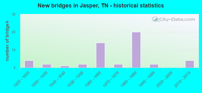
- New bridges - historical statistics
- 41920-1929
- 21930-1939
- 11940-1949
- 21950-1959
- 141960-1969
- 21970-1979
- 201980-1989
- 21990-1999
- 42010-2019

- Reconstructed bridges - Historical Statistics
- 51970-1979
- 01980-1989
- 01990-1999
- 12000-2009


- Bridge Condition - Deck
- 80.0%Good
- 16.7%Satisfactory
- 3.3%Fair

- Bridge Condition - Superstructure
- 3.3%Very good
- 63.3%Good
- 13.3%Satisfactory
- 20.0%Fair

- Bridge Condition - Substructure
- 3.3%Very good
- 70.0%Good
- 13.3%Satisfactory
- 10.0%Fair
- 3.3%Poor

- Bridge Condition - Channel
- 3.1%Very good
- 50.0%Good
- 37.5%Satisfactory
- 9.4%Fair

- Bridge Condition - Culverts
- 58.3%Good
- 33.3%Satisfactory
- 8.3%Fair
Find on map >> Show street view
Structure Number: 58SR0280023, Location: 3.6 MI N OF SR 2 (Lat: 35.109700, Lng: -85.573383), Route carried "on" structure: State highway 28, Year Built: 1989, Status: Open, Structure Length: 1.52m (4.99ft), Average Daily Traffic: 17,061 (year 2020), Truck Traffic: 9%, Average Future Daily Traffic: 15,888 (year 2040), Design Load: HS 20, Features Intersected: HALL CREEK
Minimum Vertical Clearance: 30+ m (98+ ft), Kilometerpoint: 8.755, Lanes on structure: 2, Base Highway Network: Yes, Owner: State Highway Agency, Approaching Roadway Width: 13.4m (44.0ft), Skew: 4 degrees, Material/Design: Concrete continuous, Design/Construction: Culvert, Number Of Spans In Main Unit: 2, Length of Maximum Span: 7.0m (23.0ft)
Condition: Channel: Fair, Culverts: Satisfactory, Operating Rating: 89.1 metric tons, Method Used To Determine Operating Rating: Load Factor (LF), Inventory Rating: 32.4 metric tons, Method Used To Determine Inventory Rating: Load Factor (LF), Structural Evaluation: Equal to present minimum criteria, Waterway Adequacy: Better than present minimum criteria, Approach Roadway Alignment: Equal to present desirable criteria, Designated Inspection Frequency: Every 24 months, Inspection Date: August 2020
Find on map >> Show street view
Structure Number: 58SR1500003, Location: 0.88 MI W OF JCT SR28 (Lat: 35.267683, Lng: -85.463383), Route carried "on" structure: State highway 150, Year Built: 2018, Status: Open, Structure Length: 1.77m (5.81ft), Average Daily Traffic: 2,909 (year 2020), Truck Traffic: 3%, Average Future Daily Traffic: 6,432 (year 2040), Design Load: HL 93, Features Intersected: STANDIFER BRANCH
Minimum Vertical Clearance: 30+ m (98+ ft), Kilometerpoint: 1.416, Lanes on structure: 3, Owner: State Highway Agency, Approaching Roadway Width: 17.1m (56.1ft), Skew: 1 degrees, Material/Design: Concrete continuous, Design/Construction: Culvert, Number Of Spans In Main Unit: 3, Length of Maximum Span: 6.0m (19.7ft)
Condition: Channel: Satisfactory, Culverts: Good, Operating Rating: 44.1 metric tons, Method Used To Determine Operating Rating: Assigned ratings based on Load and Resistance Factor Design (LRFD) reported by rating factor (RF) using HL93 loadings, Inventory Rating: 32.4 metric tons, Method Used To Determine Inventory Rating: Assigned ratings based on Load and Resistance Factor Design (LRFD) reported by rating factor (RF) using HL93 loadings, Structural Evaluation: Better than present minimum criteria, Waterway Adequacy: Better than present minimum criteria, Approach Roadway Alignment: Equal to present desirable criteria, Designated Inspection Frequency: Every 24 months, Inspection Date: September 2020, Deck Structure Type: Concrete Cast-file-Place, Wearing Surface/Protective System: Wearing Surface: Bituminous
Find on map >> Show street view
Structure Number: 58SR1500005, Location: 1.22 MI W OF JCT SR28 (Lat: 35.267683, Lng: -85.463383), Route carried "on" structure: State highway 150, Year Built: 2018, Status: Open, Structure Length: 2.80m (9.19ft), Average Daily Traffic: 2,909 (year 2020), Truck Traffic: 3%, Average Future Daily Traffic: 6,432 (year 2040), Design Load: HL 93, Features Intersected: PRYOR COVE CREEK
Minimum Vertical Clearance: 30+ m (98+ ft), Kilometerpoint: 1.963, Lanes on structure: 2, Owner: State Highway Agency, Approaching Roadway Width: 13.4m (44.0ft), Skew: 5 degrees, Material/Design: Concrete continuous, Design/Construction: Culvert, Number Of Spans In Main Unit: 3, Length of Maximum Span: 9.5m (31.2ft)
Condition: Channel: Good, Culverts: Good, Operating Rating: 44.1 metric tons, Method Used To Determine Operating Rating: Assigned ratings based on Load and Resistance Factor Design (LRFD) reported by rating factor (RF) using HL93 loadings, Inventory Rating: 32.4 metric tons, Method Used To Determine Inventory Rating: Assigned ratings based on Load and Resistance Factor Design (LRFD) reported by rating factor (RF) using HL93 loadings, Structural Evaluation: Better than present minimum criteria, Waterway Adequacy: Better than present minimum criteria, Approach Roadway Alignment: Equal to present desirable criteria, Designated Inspection Frequency: Every 24 months, Inspection Date: September 2020, Deck Structure Type: Concrete Cast-file-Place, Wearing Surface/Protective System: Wearing Surface: Bituminous
Find on map >> Show street view
Structure Number: 58I00240035, Location: .5 MI FROM SR 28 (Lat: 35.050250, Lng: -85.636150), Route carried "under" structure: City street 386, Year Built: 1965, Structure Length: 0. m, Average Daily Traffic: 750 (year 2022), Truck Traffic: 2%, Features Intersected: I-24 / INDUSTRIAL BLVD, Facility Carried by Structure: I24
Minimum Vertical Clearance: 7.16m (23.49ft), Kilometerpoint: 4.144, Lanes on structure: 2, Lanes under structure: 2, Material/Design: Prestressed concrete continuous, Design/Construction: Stringer/Multi-beam, Length of Maximum Span: 12.2m (40.0ft)
Find on map >> Show street view
Structure Number: 58I00240036, Location: .5 MI FROM SR 28 (Lat: 35.050467, Lng: -85.635933), Route carried "under" structure: City street 386, Year Built: 1965, Structure Length: 0. m, Average Daily Traffic: 750 (year 2022), Truck Traffic: 2%, Features Intersected: I-24 / INDUSTRIAL BLVD, Facility Carried by Structure: I24
Minimum Vertical Clearance: 7.26m (23.82ft), Kilometerpoint: 4.176, Lanes on structure: 3, Lanes under structure: 2, Material/Design: Prestressed concrete continuous, Design/Construction: Stringer/Multi-beam, Length of Maximum Span: 12.2m (40.0ft)
Find on map >> Show street view
Structure Number: 58I00240039, Location: NEAR SOUTH PITTSBURG TENN (Lat: 35.040683, Lng: -85.603533), Route carried "under" structure: Interstate 24, Year Built: 1965, Structure Length: 0. m, Average Daily Traffic: 48,699 (year 2020), Truck Traffic: 43%, Features Intersected: SHELLMOUND RD. / I-24 EB, Facility Carried by Structure: NFA 2161
Minimum Vertical Clearance: 5.44m (17.85ft), Kilometerpoint: 36.661, Lanes on structure: 2, Lanes under structure: 2, Material/Design: Concrete continuous, Design/Construction: Tee Beam, Length of Maximum Span: 18.6m (61.0ft)
Find on map >> Show street view
Structure Number: 58I00240042, Location: NEAR SOUTH PITTSBURG TENN (Lat: 35.033433, Lng: -85.581767), Route carried "under" structure: State highway 27, Year Built: 1965, Structure Length: 0. m, Average Daily Traffic: 3,422 (year 2020), Truck Traffic: 11%, Features Intersected: I-24 WB / SR-27, Facility Carried by Structure: I24
Minimum Vertical Clearance: 4.98m (16.34ft), Kilometerpoint: 6.880, Lanes on structure: 2, Lanes under structure: 2, Material/Design: Concrete continuous, Design/Construction: Tee Beam, Length of Maximum Span: 18.3m (60.0ft)
Find on map >> Show street view
Structure Number: 58I00240065, Location: 3 MI. N. NICKAJACK DAM (Lat: 35.049000, Lng: -85.630783), Route carried "under" structure: Interstate 24, Year Built: 1982, Structure Length: 0. m, Average Daily Traffic: 48,699 (year 2020), Truck Traffic: 43%, Features Intersected: SR-28 / I-24, Facility Carried by Structure: FAP 28
Minimum Vertical Clearance: 5.08m (16.67ft), Kilometerpoint: 33.941, Lanes on structure: 2, Lanes under structure: 4, Material/Design: Concrete continuous, Design/Construction: Frame, Length of Maximum Span: 33.5m (109.9ft)
Find on map >> Show street view
Structure Number: 58I00240066, Location: 3 MI. N. NICKAJACK DAM (Lat: 35.048933, Lng: -85.631100), Route carried "under" structure: Interstate 24, Year Built: 1982, Structure Length: 0. m, Average Daily Traffic: 48,399 (year 2020), Truck Traffic: 43%, Features Intersected: SR-28 / I-24, Facility Carried by Structure: FAP 28
Minimum Vertical Clearance: 5.36m (17.59ft), Kilometerpoint: 33.909, Lanes on structure: 2, Lanes under structure: 5, Material/Design: Concrete continuous, Design/Construction: Frame, Length of Maximum Span: 33.5m (109.9ft)
Find on map >> Show street view
Structure Number: 58I00240069, Location: 2.5 MI SE JCT SR2&SR150 (Lat: 35.044283, Lng: -85.602967), Route carried "under" structure: County highway 2161, Year Built: 1965, Structure Length: 0. m, Average Daily Traffic: 1,542 (year 2020), Truck Traffic: 3%, Features Intersected: I-24 / SHELLMOUND RD, Facility Carried by Structure: I24 WBL
Minimum Vertical Clearance: 4.65m (15.26ft), Kilometerpoint: 1.802, Lanes on structure: 2, Lanes under structure: 2, Material/Design: Concrete continuous, Design/Construction: Tee Beam, Length of Maximum Span: 12.8m (42.0ft)
Find on map >> Show street view
Structure Number: 58SR0020027, Location: IN JASPER (Lat: 35.071850, Lng: -85.614583), Route carried "under" structure: State highway 2, Year Built: 1988, Structure Length: 0. m, Average Daily Traffic: 7,106 (year 2020), Truck Traffic: 4%, Features Intersected: SR-28 / SR-2
Minimum Vertical Clearance: 4.98m (16.34ft), Kilometerpoint: 25.621, Lanes on structure: 2, Lanes under structure: 4, Material/Design: Prestressed concrete continuous, Design/Construction: Box Beam or Girders - Single/Spread, Length of Maximum Span: 28.3m (92.8ft)
Find on map >> Show street view
Structure Number: 58SR0020028, Location: IN JASPER (Lat: 35.072033, Lng: -85.614767), Route carried "under" structure: State highway 2, Year Built: 1988, Structure Length: 0. m, Average Daily Traffic: 10,280 (year 2020), Truck Traffic: 3%, Features Intersected: SR-28 / SR-2
Minimum Vertical Clearance: 5.21m (17.09ft), Kilometerpoint: 25.589, Lanes on structure: 2, Lanes under structure: 4, Material/Design: Prestressed concrete, Design/Construction: Box Beam or Girders - Single/Spread, Length of Maximum Span: 28.3m (92.8ft)