Bridge Statistics for Jackson, Tennessee (TN)
Condition, Traffic, Stress, Structural Evaluation, Project Costs
- National Bridge Inventory (NBI) Statistics
- 259Number of bridges
- 3,028ft / 923mTotal length
- $125,733,000Total costs
- 2,940,160Total average daily traffic
- 494,139Total average daily truck traffic
- National Bridge Inventory (NBI) Registered Bridges for Jackson
- No street view available for this location
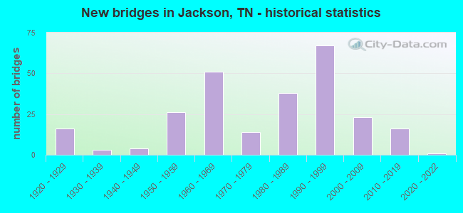
- New bridges - historical statistics
- 161920-1929
- 31930-1939
- 41940-1949
- 261950-1959
- 511960-1969
- 141970-1979
- 381980-1989
- 671990-1999
- 232000-2009
- 162010-2019
- 12020-2022
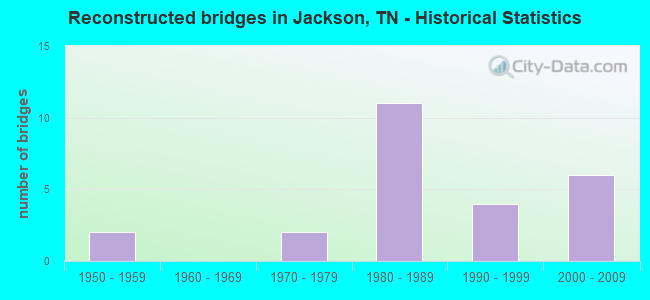
- Reconstructed bridges - Historical Statistics
- 21950-1959
- 01960-1969
- 21970-1979
- 111980-1989
- 41990-1999
- 62000-2009
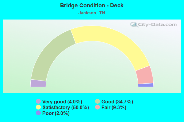
- Bridge Condition - Deck
- 4.0%Very good
- 34.7%Good
- 50.0%Satisfactory
- 9.3%Fair
- 2.0%Poor
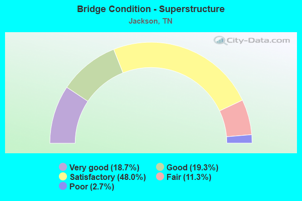
- Bridge Condition - Superstructure
- 18.7%Very good
- 19.3%Good
- 48.0%Satisfactory
- 11.3%Fair
- 2.7%Poor
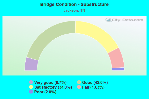
- Bridge Condition - Substructure
- 8.7%Very good
- 42.0%Good
- 34.0%Satisfactory
- 13.3%Fair
- 2.0%Poor
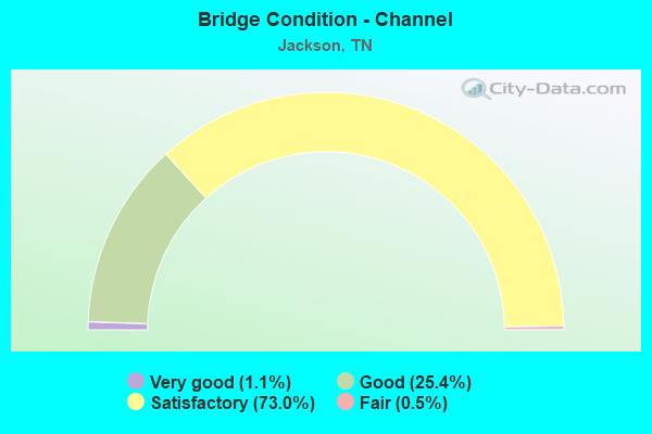
- Bridge Condition - Channel
- 1.1%Very good
- 25.4%Good
- 73.0%Satisfactory
- 0.5%Fair
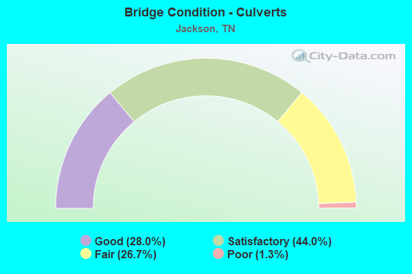
- Bridge Condition - Culverts
- 28.0%Good
- 44.0%Satisfactory
- 26.7%Fair
- 1.3%Poor
Find on map >> Show street view
Structure Number: 57SR0050032, Location: 1.5 MI.SOUTH OF FAIRVIEW (Lat: 35.739889, Lng: -88.848611), Route carried "on" structure: US 45, Year Built: 1967, Year Reconstructed: 2003, Status: Open, Structure Length: 3.96m (12.99ft), Average Daily Traffic: 26,888 (year 2020), Truck Traffic: 9%, Average Future Daily Traffic: 43,021 (year 2041), Design Load: HS 20+Mod, Features Intersected: IC RR, Facility Carried by Structure: FAP 5 299409H
Minimum Vertical Clearance: 30+ m (98+ ft), Kilometerpoint: 34.842, Lanes on structure: 2, Base Highway Network: Yes, Owner: State Highway Agency, Approaching Roadway Width: 11.0m (36.1ft), Skew: 10 degrees, Material/Design: Prestressed concrete, Design/Construction: Stringer/Multi-beam, Number Of Spans In Main Unit: 3, Length of Maximum Span: 13.4m (44.0ft), Curb-To-Curb Width: 18.4m (60.4ft), Out-to-Out Width: 19.1m (62.7ft)
Condition: Deck: Satisfactory, Superstructure: Satisfactory, Substructure: Good, Operating Rating: 63.0 metric tons, Method Used To Determine Operating Rating: Load Factor (LF), Inventory Rating: 32.4 metric tons, Method Used To Determine Inventory Rating: Load Factor (LF), Structural Evaluation: Equal to present minimum criteria, Deck Geometry: Superior to present desirable criteria, Underclear: Somewhat better than minimum adequacy, Approach Roadway Alignment: Equal to present desirable criteria, Designated Inspection Frequency: Every 24 months, Inspection Date: April 2021, Deck Structure Type: Concrete Cast-file-Place, Wearing Surface/Protective System: Wearing Surface: Bituminous
Find on map >> Show street view
Structure Number: 57SR0050037, Location: IN JACKSON (Lat: 35.539806, Lng: -88.792944), Route carried "on" structure: US 45, Year Built: 1968, Status: Open, Structure Length: 0.73m (2.40ft), Average Daily Traffic: 19,618 (year 2020), Truck Traffic: 11%, Average Future Daily Traffic: 31,389 (year 2041), Design Load: HS 20, Features Intersected: BRANCH, Facility Carried by Structure: FAP 5
Minimum Vertical Clearance: 30+ m (98+ ft), Kilometerpoint: 10.783, Lanes on structure: 4, Base Highway Network: Yes, Owner: State Highway Agency, Approaching Roadway Width: 25.0m (82.0ft), Skew: 1 degrees, Material/Design: Concrete continuous, Design/Construction: Culvert, Number Of Spans In Main Unit: 2, Length of Maximum Span: 3.0m (9.8ft)
Condition: Channel: Satisfactory, Culverts: Good, Operating Rating: 89.1 metric tons, Method Used To Determine Operating Rating: Load Factor (LF), Inventory Rating: 32.4 metric tons, Method Used To Determine Inventory Rating: Load Factor (LF), Structural Evaluation: Better than present minimum criteria, Waterway Adequacy: Equal to present minimum criteria, Approach Roadway Alignment: Equal to present desirable criteria, Length Of Structure Improvement: 0.73m (2.40ft), Designated Inspection Frequency: Every 24 months, Inspection Date: April 2021, Bridge Improvement Cost: $235,000, Roadway Improvement Cost: $24,000, Total Project Cost: $353,000 ( Estimate for 2021)
Find on map >> Show street view
Structure Number: 57SR0050043, Location: N OF JACKSON CITY LIMITS (Lat: 35.733778, Lng: -88.850028), Route carried "on" structure: US 45, Year Built: 1997, Status: Open, Structure Length: 8.87m (29.10ft), Average Daily Traffic: 12,950 (year 2020), Truck Traffic: 4%, Average Future Daily Traffic: 20,720 (year 2041), Design Load: HS 20, Features Intersected: SR 186, Facility Carried by Structure: FAP 5
Minimum Vertical Clearance: 30+ m (98+ ft), Kilometerpoint: 34.086, Lanes on structure: 2, Lanes under structure: 5, Base Highway Network: Yes, Owner: State Highway Agency, Approaching Roadway Width: 12.8m (42.0ft), Skew: 12 degrees, Material/Design: Prestressed concrete continuous, Design/Construction: Stringer/Multi-beam, Number Of Spans In Main Unit: 4, Length of Maximum Span: 28.3m (92.8ft), Curb-To-Curb Width: 12.8m (42.0ft), Out-to-Out Width: 13.4m (44.0ft)
Condition: Deck: Good, Superstructure: Satisfactory, Substructure: Good, Operating Rating: 44.1 metric tons, Method Used To Determine Operating Rating: Assigned rating based on Load Factor Design (LFD) reported in metric tons, Inventory Rating: 32.4 metric tons, Method Used To Determine Inventory Rating: Assigned rating based on Load Factor Design (LFD) reported in metric tons, Structural Evaluation: Equal to present minimum criteria, Deck Geometry: Equal to present desirable criteria, Underclear: Equal to present desirable criteria, Approach Roadway Alignment: Equal to present desirable criteria, Designated Inspection Frequency: Every 24 months, Inspection Date: April 2021, Deck Structure Type: Concrete Precast Panels, Wearing Surface/Protective System: Wearing Surface: Monolithic Concrete, Deck Protection: Epoxy Coated Reinforcing
Find on map >> Show street view
Structure Number: 57SR0050044, Location: N OF JACKSON CITY LIMITS (Lat: 35.733472, Lng: -88.850083), Route carried "on" structure: US 45, Year Built: 1997, Status: Open, Structure Length: 8.87m (29.10ft), Average Daily Traffic: 12,950 (year 2020), Truck Traffic: 4%, Average Future Daily Traffic: 20,720 (year 2041), Design Load: HS 20, Features Intersected: SR 186, Facility Carried by Structure: FAP 5
Minimum Vertical Clearance: 30+ m (98+ ft), Kilometerpoint: 34.086, Lanes on structure: 3, Lanes under structure: 5, Base Highway Network: Yes, Owner: State Highway Agency, Approaching Roadway Width: 29.3m (96.1ft), Skew: 12 degrees, Material/Design: Prestressed concrete continuous, Design/Construction: Stringer/Multi-beam, Number Of Spans In Main Unit: 4, Length of Maximum Span: 28.3m (92.8ft), Curb-To-Curb Width: 16.5m (54.1ft), Out-to-Out Width: 17.1m (56.1ft)
Condition: Deck: Good, Superstructure: Satisfactory, Substructure: Good, Operating Rating: 55.4 metric tons, Method Used To Determine Operating Rating: Load Factor (LF), Inventory Rating: 32.4 metric tons, Method Used To Determine Inventory Rating: Load Factor (LF), Structural Evaluation: Equal to present minimum criteria, Deck Geometry: Better than present minimum criteria, Underclear: Better than present minimum criteria, Approach Roadway Alignment: Equal to present desirable criteria, Designated Inspection Frequency: Every 24 months, Inspection Date: April 2021, Deck Structure Type: Concrete Precast Panels, Wearing Surface/Protective System: Wearing Surface: Monolithic Concrete, Deck Protection: Epoxy Coated Reinforcing
Find on map >> Show street view
Structure Number: 57SR0050045, Location: N OF JACKSON CITY LIMITS (Lat: 35.713167, Lng: -88.835900), Route carried "on" structure: US 45, Year Built: 2013, Status: Open, Structure Length: 0.94m (3.08ft), Average Daily Traffic: 13,311 (year 2020), Truck Traffic: 4%, Average Future Daily Traffic: 21,298 (year 2041), Design Load: HS 20, Features Intersected: BRANCH, Facility Carried by Structure: FAP 5
Minimum Vertical Clearance: 30+ m (98+ ft), Kilometerpoint: 31.415, Lanes on structure: 5, Owner: State Highway Agency, Approaching Roadway Width: 19.5m (64.0ft), Skew: 14 degrees, Material/Design: Concrete continuous, Design/Construction: Culvert, Number Of Spans In Main Unit: 2, Length of Maximum Span: 3.0m (9.8ft)
Condition: Channel: Satisfactory, Culverts: Good, Operating Rating: 54.1 metric tons, Method Used To Determine Operating Rating: Assigned ratings based on Load and Resistance Factor Design (LRFD) reported by rating factor (RF) using HL93 loadings, Inventory Rating: 32.4 metric tons, Method Used To Determine Inventory Rating: Assigned ratings based on Load and Resistance Factor Design (LRFD) reported by rating factor (RF) using HL93 loadings, Structural Evaluation: Better than present minimum criteria, Waterway Adequacy: Better than present minimum criteria, Approach Roadway Alignment: Equal to present desirable criteria, Length Of Structure Improvement: 0.94m (3.08ft), Designated Inspection Frequency: Every 24 months, Inspection Date: April 2021, Bridge Improvement Cost: $466,000, Roadway Improvement Cost: $47,000, Total Project Cost: $700,000 ( Estimate for 2021)
Find on map >> Show street view
Structure Number: 57SR0200001, Location: CROCKETT-MADISON CO LN (Lat: 35.691139, Lng: -88.983611), Route carried "on" structure: US 412, Year Built: 1991, Status: Open, Structure Length: 2.65m (8.69ft), Average Daily Traffic: 17,173 (year 2020), Truck Traffic: 11%, Average Future Daily Traffic: 27,477 (year 2041), Design Load: HS 20, Features Intersected: CONNLEY CREEK, Facility Carried by Structure: FAP 20
Minimum Vertical Clearance: 30+ m (98+ ft), Kilometerpoint: 0.048, Lanes on structure: 2, Base Highway Network: Yes, Owner: State Highway Agency, Approaching Roadway Width: 12.8m (42.0ft), Material/Design: Prestressed concrete continuous, Design/Construction: Stringer/Multi-beam, Number Of Spans In Main Unit: 3, Length of Maximum Span: 8.8m (28.9ft), Curb-To-Curb Width: 12.8m (42.0ft), Out-to-Out Width: 13.4m (44.0ft)
Condition: Deck: Satisfactory, Superstructure: Good, Substructure: Good, Channel: Satisfactory, Operating Rating: 46.8 metric tons, Method Used To Determine Operating Rating: Load Factor (LF), Inventory Rating: 32.4 metric tons, Method Used To Determine Inventory Rating: Load Factor (LF), Structural Evaluation: Better than present minimum criteria, Deck Geometry: Somewhat better than minimum adequacy, Waterway Adequacy: Equal to present desirable criteria, Approach Roadway Alignment: Equal to present desirable criteria, Designated Inspection Frequency: Every 24 months, Inspection Date: April 2021, Deck Structure Type: Concrete Precast Panels, Wearing Surface/Protective System: Wearing Surface: Monolithic Concrete, Deck Protection: Epoxy Coated Reinforcing
Find on map >> Show street view
Structure Number: 57SR0200005, Location: 4.2 MI.NW. OF JACKSON (Lat: 35.676278, Lng: -88.948056), Route carried "on" structure: County highway 50, Year Built: 1958, Status: Open, Structure Length: 1.01m (3.31ft), Average Daily Traffic: 510 (year 2022), Truck Traffic: 8%, Average Future Daily Traffic: 816 (year 2041), Design Load: HS 20, Features Intersected: ADAIR CREEK
Minimum Vertical Clearance: 30+ m (98+ ft), Kilometerpoint: 1.725, Lanes on structure: 2, Owner: County Highway Agency, Approaching Roadway Width: 10.4m (34.1ft), Material/Design: Concrete continuous, Design/Construction: Culvert, Number Of Spans In Main Unit: 2, Length of Maximum Span: 4.6m (15.1ft)
Condition: Channel: Satisfactory, Culverts: Satisfactory, Operating Rating: 54.0 metric tons, Method Used To Determine Operating Rating: Field evaluation and documented engineering judgment, Inventory Rating: 32.4 metric tons, Method Used To Determine Inventory Rating: Field evaluation and documented engineering judgment, Structural Evaluation: Equal to present minimum criteria, Waterway Adequacy: Equal to present minimum criteria, Approach Roadway Alignment: Equal to present desirable criteria, Designated Inspection Frequency: Every 24 months, Inspection Date: April 2021
Find on map >> Show street view
Structure Number: 57SR0200007, Location: IN JACKSON CITY LIMITS (Lat: 35.650167, Lng: -88.869917), Route carried "on" structure: US 412, Year Built: 2011, Status: Open, Structure Length: 2.00m (6.56ft), Average Daily Traffic: 15,738 (year 2020), Truck Traffic: 9%, Average Future Daily Traffic: 25,181 (year 2041), Design Load: HL 93, Features Intersected: OLD HICKORY CREEK, Facility Carried by Structure: FAP 20
Minimum Vertical Clearance: 30+ m (98+ ft), Kilometerpoint: 13.004, Lanes on structure: 5, Base Highway Network: Yes, Owner: State Highway Agency, Approaching Roadway Width: 19.5m (64.0ft), Material/Design: Prestressed concrete, Design/Construction: Box Beam or Girders - Single/Spread, Number Of Spans In Main Unit: 1, Length of Maximum Span: 19.1m (62.7ft), Curb or Sidewalk Widths: Left: 1.5m (4.9ft), Right: 1.5m (4.9ft), Curb-To-Curb Width: 20.7m (67.9ft), Out-to-Out Width: 24.4m (80.1ft)
Condition: Deck: Satisfactory, Superstructure: Very good, Substructure: Very good, Channel: Satisfactory, Operating Rating: 89.1 metric tons, Method Used To Determine Operating Rating: Load Factor (LF), Inventory Rating: 32.4 metric tons, Method Used To Determine Inventory Rating: Load Factor (LF), Structural Evaluation: Equal to present desirable criteria, Deck Geometry: Somewhat better than minimum adequacy, Waterway Adequacy: Equal to present minimum criteria, Approach Roadway Alignment: Equal to present desirable criteria, Designated Inspection Frequency: Every 24 months, Inspection Date: April 2021, Deck Structure Type: Concrete Precast Panels, Wearing Surface/Protective System: Wearing Surface: Monolithic Concrete, Deck Protection: Epoxy Coated Reinforcing
Find on map >> Show street view
Structure Number: 57SR0200009, Location: 6 MI.NW. OF JACKSON (Lat: 35.644444, Lng: -88.858861), Route carried "on" structure: US 412, Year Built: 1929, Status: Open, Structure Length: 0.73m (2.40ft), Average Daily Traffic: 15,738 (year 2020), Truck Traffic: 9%, Average Future Daily Traffic: 25,181 (year 2041), Design Load: H 15, Features Intersected: BRANCH, Facility Carried by Structure: FAP 20
Minimum Vertical Clearance: 30+ m (98+ ft), Kilometerpoint: 14.371, Lanes on structure: 2, Base Highway Network: Yes, Owner: State Highway Agency, Approaching Roadway Width: 10.4m (34.1ft), Material/Design: Concrete continuous, Design/Construction: Culvert, Number Of Spans In Main Unit: 2, Length of Maximum Span: 3.0m (9.8ft)
Condition: Channel: Satisfactory, Culverts: Satisfactory, Operating Rating: 89.1 metric tons, Method Used To Determine Operating Rating: Load Factor (LF), Inventory Rating: 32.4 metric tons, Method Used To Determine Inventory Rating: Load Factor (LF), Structural Evaluation: Equal to present minimum criteria, Waterway Adequacy: Better than present minimum criteria, Approach Roadway Alignment: Equal to present minimum criteria, Designated Inspection Frequency: Every 24 months, Inspection Date: April 2021
Find on map >> Show street view
Structure Number: 57SR0200011, Location: IN JACKSON CITY LIMITS (Lat: 35.626056, Lng: -88.838972), Route carried "on" structure: City street 3042, Year Built: 1929, Status: Open, Structure Length: 1.74m (5.71ft), Average Daily Traffic: 8,371 (year 2020), Truck Traffic: 3%, Average Future Daily Traffic: 14,624 (year 2041), Design Load: H 15, Features Intersected: SANDY CREEK
Minimum Vertical Clearance: 30+ m (98+ ft), Kilometerpoint: 2.736, Lanes on structure: 4, Owner: City or Municipal Highway Agency, Approaching Roadway Width: 15.8m (51.8ft), Material/Design: Concrete, Design/Construction: Tee Beam, Number Of Spans In Main Unit: 2, Length of Maximum Span: 8.8m (28.9ft), Curb or Sidewalk Widths: Left: 1.5m (4.9ft), Right: 1.5m (4.9ft), Curb-To-Curb Width: 12.2m (40.0ft), Out-to-Out Width: 16.0m (52.5ft)
Condition: Deck: Satisfactory, Superstructure: Satisfactory, Substructure: Satisfactory, Channel: Satisfactory, Operating Rating: 48.6 metric tons, Method Used To Determine Operating Rating: Allowable Stress (AS), Inventory Rating: 31.5 metric tons, Method Used To Determine Inventory Rating: Allowable Stress (AS), Structural Evaluation: Equal to present minimum criteria, Deck Geometry: High priority of replacement, Waterway Adequacy: Equal to present minimum criteria, Approach Roadway Alignment: Equal to present desirable criteria, Length Of Structure Improvement: 1.74m (5.71ft), Designated Inspection Frequency: Every 24 months, Inspection Date: May 2021, Bridge Improvement Cost: $255,000, Roadway Improvement Cost: $26,000, Total Project Cost: $383,000 ( Estimate for 2021), Deck Structure Type: Concrete Cast-file-Place, Wearing Surface/Protective System: Wearing Surface: Bituminous
Find on map >> Show street view
Structure Number: 57SR0200015, Location: IN JACKSON CITY LIMITS (Lat: 35.665444, Lng: -88.881639), Route carried "on" structure: City street 50, Year Built: 1991, Status: Open, Structure Length: 6.61m (21.69ft), Average Daily Traffic: 4,640 (year 2022), Truck Traffic: 7%, Average Future Daily Traffic: 7,424 (year 2041), Design Load: HS 20, Features Intersected: NFA A050/SR 20
Minimum Vertical Clearance: 30+ m (98+ ft), Kilometerpoint: 8.100, Lanes on structure: 3, Lanes under structure: 4, Owner: State Highway Agency, Approaching Roadway Width: 17.1m (56.1ft), Material/Design: Prestressed concrete continuous, Design/Construction: Box Beam or Girders - Single/Spread, Number Of Spans In Main Unit: 2, Length of Maximum Span: 32.9m (107.9ft), Curb-To-Curb Width: 17.1m (56.1ft), Out-to-Out Width: 17.7m (58.1ft)
Condition: Deck: Satisfactory, Superstructure: Fair, Substructure: Good, Operating Rating: 50.9 metric tons, Method Used To Determine Operating Rating: Load Factor (LF), Inventory Rating: 32.4 metric tons, Method Used To Determine Inventory Rating: Load Factor (LF), Structural Evaluation: Somewhat better than minimum adequacy, Deck Geometry: Superior to present desirable criteria, Underclear: Better than present minimum criteria, Approach Roadway Alignment: Equal to present desirable criteria, Designated Inspection Frequency: Every 24 months, Inspection Date: April 2021, Deck Structure Type: Concrete Precast Panels, Wearing Surface/Protective System: Wearing Surface: Monolithic Concrete, Deck Protection: Epoxy Coated Reinforcing
Find on map >> Show street view
Structure Number: 57SR0200017, Location: IN THE CITY OF JACKSON (Lat: 35.667306, Lng: -88.894083), Route carried "on" structure: US 412, Year Built: 1991, Status: Open, Structure Length: 48.31m (158.50ft), Average Daily Traffic: 10,984 (year 2020), Truck Traffic: 9%, Average Future Daily Traffic: 17,574 (year 2041), Design Load: HS 20, Features Intersected: NFA A050 & BRANCH, Facility Carried by Structure: FAU 20
Minimum Vertical Clearance: 30+ m (98+ ft), Kilometerpoint: 9.994, Lanes on structure: 2, Lanes under structure: 2, Base Highway Network: Yes, Owner: State Highway Agency, Approaching Roadway Width: 13.4m (44.0ft), Skew: 10 degrees, Material/Design: Steel continuous, Design/Construction: Stringer/Multi-beam, Number Of Spans In Main Unit: 4, Number Of Approach Spans: 11, Length of Maximum Span: 63.7m (209.0ft), Curb-To-Curb Width: 12.8m (42.0ft), Out-to-Out Width: 13.4m (44.0ft)
Condition: Deck: Satisfactory, Superstructure: Satisfactory, Substructure: Good, Channel: Very good, Operating Rating: 56.7 metric tons, Method Used To Determine Operating Rating: Load Factor (LF), Inventory Rating: 32.4 metric tons, Method Used To Determine Inventory Rating: Load Factor (LF), Structural Evaluation: Equal to present minimum criteria, Deck Geometry: Equal to present desirable criteria, Underclear: Better than present minimum criteria, Waterway Adequacy: Superior to present desirable criteria, Approach Roadway Alignment: Equal to present desirable criteria, Length Of Structure Improvement: 48.31m (158.50ft), Designated Inspection Frequency: Every 24 months, Inspection Date: April 2021, Bridge Improvement Cost: $13,496,000, Roadway Improvement Cost: $1,350,000, Total Project Cost: $20,245,000 ( Estimate for 2021), Deck Structure Type: Concrete Precast Panels, Wearing Surface/Protective System: Wearing Surface: Monolithic Concrete, Membrane: Other, Deck Protection: Other
Find on map >> Show street view
Structure Number: 57SR0200018, Location: IN THE CITY OF JACKSON (Lat: 35.667000, Lng: -88.893528), Route carried "on" structure: US 412, Year Built: 1991, Status: Open, Structure Length: 40.72m (133.60ft), Average Daily Traffic: 10,984 (year 2020), Truck Traffic: 9%, Average Future Daily Traffic: 17,574 (year 2041), Design Load: HS 20, Features Intersected: NFA A050 & BRANCH, Facility Carried by Structure: FAU 20
Minimum Vertical Clearance: 30+ m (98+ ft), Kilometerpoint: 10.042, Lanes on structure: 2, Lanes under structure: 2, Base Highway Network: Yes, Owner: State Highway Agency, Approaching Roadway Width: 13.4m (44.0ft), Skew: 10 degrees, Material/Design: Steel continuous, Design/Construction: Stringer/Multi-beam, Number Of Spans In Main Unit: 4, Number Of Approach Spans: 8, Length of Maximum Span: 63.7m (209.0ft), Curb-To-Curb Width: 12.8m (42.0ft), Out-to-Out Width: 13.4m (44.0ft)
Condition: Deck: Satisfactory, Superstructure: Satisfactory, Substructure: Satisfactory, Channel: Very good, Operating Rating: 56.7 metric tons, Method Used To Determine Operating Rating: Load Factor (LF), Inventory Rating: 32.4 metric tons, Method Used To Determine Inventory Rating: Load Factor (LF), Structural Evaluation: Equal to present minimum criteria, Deck Geometry: Equal to present desirable criteria, Underclear: Somewhat better than minimum adequacy, Waterway Adequacy: Superior to present desirable criteria, Approach Roadway Alignment: Equal to present desirable criteria, Length Of Structure Improvement: 40.72m (133.60ft), Designated Inspection Frequency: Every 24 months, Inspection Date: April 2021, Bridge Improvement Cost: $11,428,000, Roadway Improvement Cost: $1,143,000, Total Project Cost: $17,143,000 ( Estimate for 2021), Deck Structure Type: Concrete Precast Panels, Wearing Surface/Protective System: Wearing Surface: Monolithic Concrete, Membrane: Other, Deck Protection: Other
Find on map >> Show street view
Structure Number: 57SR0200021, Location: N OF JACKSON (Lat: 35.671667, Lng: -88.949750), Route carried "on" structure: US 412, Year Built: 1991, Status: Open, Structure Length: 1.19m (3.90ft), Average Daily Traffic: 10,984 (year 2020), Truck Traffic: 9%, Average Future Daily Traffic: 17,574 (year 2041), Design Load: HS 20, Features Intersected: ADAIR BRANCH, Facility Carried by Structure: FAP 20
Minimum Vertical Clearance: 30+ m (98+ ft), Kilometerpoint: 4.925, Lanes on structure: 4, Base Highway Network: Yes, Owner: State Highway Agency, Approaching Roadway Width: 24.4m (80.1ft), Skew: 10 degrees, Material/Design: Concrete continuous, Design/Construction: Culvert, Number Of Spans In Main Unit: 3, Length of Maximum Span: 3.7m (12.1ft)
Condition: Channel: Good, Culverts: Good, Operating Rating: 54.0 metric tons, Method Used To Determine Operating Rating: Field evaluation and documented engineering judgment, Inventory Rating: 32.4 metric tons, Method Used To Determine Inventory Rating: Field evaluation and documented engineering judgment, Structural Evaluation: Better than present minimum criteria, Waterway Adequacy: Equal to present desirable criteria, Approach Roadway Alignment: Equal to present desirable criteria, Length Of Structure Improvement: 1.19m (3.90ft), Designated Inspection Frequency: Every 24 months, Inspection Date: April 2021, Bridge Improvement Cost: $395,000, Roadway Improvement Cost: $40,000, Total Project Cost: $593,000 ( Estimate for 2021)
Find on map >> Show street view
Structure Number: 57SR0200023, Location: N OF JACKSON (Lat: 35.668083, Lng: -88.914528), Route carried "on" structure: US 412, Year Built: 1991, Status: Open, Structure Length: 0.82m (2.69ft), Average Daily Traffic: 10,984 (year 2020), Truck Traffic: 9%, Average Future Daily Traffic: 17,574 (year 2041), Design Load: HS 20, Features Intersected: BRANCH, Facility Carried by Structure: FAP 20
Minimum Vertical Clearance: 30+ m (98+ ft), Kilometerpoint: 8.127, Lanes on structure: 4, Base Highway Network: Yes, Owner: State Highway Agency, Approaching Roadway Width: 24.4m (80.1ft), Skew: 10 degrees, Material/Design: Concrete continuous, Design/Construction: Culvert, Number Of Spans In Main Unit: 2, Length of Maximum Span: 3.7m (12.1ft)
Condition: Channel: Good, Culverts: Satisfactory, Operating Rating: 89.9 metric tons, Method Used To Determine Operating Rating: Load Factor (LF), Inventory Rating: 32.4 metric tons, Method Used To Determine Inventory Rating: Load Factor (LF), Structural Evaluation: Equal to present minimum criteria, Waterway Adequacy: Equal to present desirable criteria, Approach Roadway Alignment: Equal to present desirable criteria, Length Of Structure Improvement: 0.82m (2.69ft), Designated Inspection Frequency: Every 24 months, Inspection Date: April 2021, Bridge Improvement Cost: $284,000, Roadway Improvement Cost: $29,000, Total Project Cost: $427,000 ( Estimate for 2021)
Find on map >> Show street view
Structure Number: 57SR0200025, Location: IN THE CITY OF JACKSON (Lat: 35.667694, Lng: -88.888972), Route carried "on" structure: City street 3053, Year Built: 1991, Status: Open, Structure Length: 0.73m (2.40ft), Average Daily Traffic: 1,657 (year 2020), Truck Traffic: 4%, Average Future Daily Traffic: 6,464 (year 2039), Design Load: HS 20, Features Intersected: BRANCH
Minimum Vertical Clearance: 30+ m (98+ ft), Kilometerpoint: 0.837, Lanes on structure: 2, Owner: City or Municipal Highway Agency, Approaching Roadway Width: 10.4m (34.1ft), Material/Design: Concrete continuous, Design/Construction: Culvert, Number Of Spans In Main Unit: 2, Length of Maximum Span: 3.0m (9.8ft)
Condition: Channel: Good, Culverts: Satisfactory, Operating Rating: 86.4 metric tons, Method Used To Determine Operating Rating: Load Factor (LF), Inventory Rating: 32.4 metric tons, Method Used To Determine Inventory Rating: Load Factor (LF), Structural Evaluation: Equal to present minimum criteria, Waterway Adequacy: Better than present minimum criteria, Approach Roadway Alignment: Equal to present minimum criteria, Designated Inspection Frequency: Every 24 months, Inspection Date: May 2021
Find on map >> Show street view
Structure Number: 57SR0200027, Location: IN THE CITY OF JACKSON (Lat: 35.662250, Lng: -88.880083), Route carried "on" structure: US 412, Year Built: 1990, Status: Open, Structure Length: 0.85m (2.79ft), Average Daily Traffic: 19,813 (year 2020), Truck Traffic: 9%, Average Future Daily Traffic: 31,701 (year 2041), Design Load: HS 20, Features Intersected: BRANCH, Facility Carried by Structure: FAP 20
Minimum Vertical Clearance: 30+ m (98+ ft), Kilometerpoint: 11.571, Lanes on structure: 5, Base Highway Network: Yes, Owner: State Highway Agency, Approaching Roadway Width: 29.6m (97.1ft), Skew: 2 degrees, Material/Design: Concrete continuous, Design/Construction: Culvert, Number Of Spans In Main Unit: 2, Length of Maximum Span: 3.7m (12.1ft)
Condition: Channel: Satisfactory, Culverts: Satisfactory, Operating Rating: 89.9 metric tons, Method Used To Determine Operating Rating: Load Factor (LF), Inventory Rating: 32.4 metric tons, Method Used To Determine Inventory Rating: Load Factor (LF), Structural Evaluation: Equal to present minimum criteria, Waterway Adequacy: Equal to present desirable criteria, Approach Roadway Alignment: Equal to present desirable criteria, Designated Inspection Frequency: Every 24 months, Inspection Date: April 2021
Find on map >> Show street view
Structure Number: 57SR1860001, Location: IN THE CITY OF JACKSON (Lat: 35.669500, Lng: -88.855083), Route carried "on" structure: Ramp State highway 186, Year Built: 1997, Status: Open, Structure Length: 5.91m (19.39ft), Average Daily Traffic: 59,484 (year 2020), Truck Traffic: 9%, Average Future Daily Traffic: 5,024 (year 2041), Design Load: HS 20, Features Intersected: FAU 3049 - VANN DR
Minimum Vertical Clearance: 30+ m (98+ ft), Kilometerpoint: 6.003, Lanes on structure: 1, Lanes under structure: 7, Base Highway Network: Yes, Owner: State Highway Agency, Approaching Roadway Width: 9.1m (29.9ft), Material/Design: Steel continuous, Design/Construction: Stringer/Multi-beam, Number Of Spans In Main Unit: 3, Length of Maximum Span: 37.5m (123.0ft), Curb-To-Curb Width: 9.1m (29.9ft), Out-to-Out Width: 9.8m (32.2ft)
Condition: Deck: Good, Superstructure: Good, Substructure: Good, Operating Rating: 45.0 metric tons, Method Used To Determine Operating Rating: Load and Resistance Factor Rating (LRFR) rating reported by rating factor(RF) method using HL-93 loadings, Inventory Rating: 35.0 metric tons, Method Used To Determine Inventory Rating: Load and Resistance Factor Rating (LRFR) rating reported by rating factor(RF) method using HL-93 loadings, Structural Evaluation: Better than present minimum criteria, Deck Geometry: Superior to present desirable criteria, Underclear: High priority of corrective action, Approach Roadway Alignment: Equal to present desirable criteria, Designated Inspection Frequency: Every 24 months, Inspection Date: April 2021, Deck Structure Type: Concrete Precast Panels, Wearing Surface/Protective System: Wearing Surface: Monolithic Concrete, Deck Protection: Epoxy Coated Reinforcing
Find on map >> Show street view
Structure Number: 57SR1860003, Location: IN THE CITY OF JACKSON (Lat: 35.669611, Lng: -88.854472), Route carried "on" structure: State highway 186, Year Built: 1997, Status: Open, Structure Length: 5.91m (19.39ft), Average Daily Traffic: 59,484 (year 2020), Truck Traffic: 9%, Average Future Daily Traffic: 75,376 (year 2041), Design Load: HS 20, Features Intersected: FAU 3049 - VANN DR
Minimum Vertical Clearance: 30+ m (98+ ft), Kilometerpoint: 6.003, Lanes on structure: 4, Lanes under structure: 7, Base Highway Network: Yes, Owner: State Highway Agency, Approaching Roadway Width: 26.2m (86.0ft), Skew: 30 degrees, Material/Design: Steel continuous, Design/Construction: Stringer/Multi-beam, Number Of Spans In Main Unit: 3, Length of Maximum Span: 37.5m (123.0ft), Curb-To-Curb Width: 25.7m (84.3ft), Out-to-Out Width: 26.8m (87.9ft)
Condition: Deck: Good, Superstructure: Good, Substructure: Very good, Operating Rating: 46.0 metric tons, Method Used To Determine Operating Rating: Load and Resistance Factor Rating (LRFR) rating reported by rating factor(RF) method using HL-93 loadings, Inventory Rating: 36.0 metric tons, Method Used To Determine Inventory Rating: Load and Resistance Factor Rating (LRFR) rating reported by rating factor(RF) method using HL-93 loadings, Structural Evaluation: Better than present minimum criteria, Deck Geometry: Superior to present desirable criteria, Underclear: High priority of corrective action, Approach Roadway Alignment: Equal to present desirable criteria, Designated Inspection Frequency: Every 24 months, Inspection Date: April 2021, Deck Structure Type: Concrete Precast Panels, Wearing Surface/Protective System: Wearing Surface: Monolithic Concrete, Deck Protection: Epoxy Coated Reinforcing
Find on map >> Show street view
Structure Number: 57SR1860005, Location: IN THE CITY OF JACKSON (Lat: 35.669528, Lng: -88.856000), Route carried "on" structure: Ramp State highway 186, Year Built: 1997, Status: Open, Structure Length: 5.91m (19.39ft), Average Daily Traffic: 59,484 (year 2020), Truck Traffic: 9%, Average Future Daily Traffic: 56,400 (year 2041), Design Load: HS 20, Features Intersected: FAU 3049 - VANN DR
Minimum Vertical Clearance: 30+ m (98+ ft), Kilometerpoint: 6.003, Lanes on structure: 1, Lanes under structure: 7, Base Highway Network: Yes, Owner: State Highway Agency, Approaching Roadway Width: 9.1m (29.9ft), Material/Design: Steel continuous, Design/Construction: Stringer/Multi-beam, Number Of Spans In Main Unit: 3, Length of Maximum Span: 37.5m (123.0ft), Curb-To-Curb Width: 9.1m (29.9ft), Out-to-Out Width: 9.8m (32.2ft)
Condition: Deck: Good, Superstructure: Good, Substructure: Good, Operating Rating: 61.2 metric tons, Method Used To Determine Operating Rating: Load Factor (LF), Inventory Rating: 36.9 metric tons, Method Used To Determine Inventory Rating: Load Factor (LF), Structural Evaluation: Better than present minimum criteria, Deck Geometry: Superior to present desirable criteria, Underclear: High priority of corrective action, Approach Roadway Alignment: Equal to present desirable criteria, Designated Inspection Frequency: Every 24 months, Inspection Date: April 2021, Deck Structure Type: Concrete Precast Panels, Wearing Surface/Protective System: Wearing Surface: Monolithic Concrete, Deck Protection: Epoxy Coated Reinforcing
Find on map >> Show street view
Structure Number: 57SR2230017, Location: .1 MI S OF I40 (Lat: 35.640500, Lng: -88.916944), Route carried "on" structure: State highway 223, Year Built: 1995, Status: Open, Structure Length: 0.82m (2.69ft), Average Daily Traffic: 5,911 (year 2020), Truck Traffic: 4%, Average Future Daily Traffic: 9,458 (year 2041), Design Load: HS 20, Features Intersected: BRANCH
Minimum Vertical Clearance: 30+ m (98+ ft), Kilometerpoint: 24.140, Lanes on structure: 2, Owner: State Highway Agency, Approaching Roadway Width: 14.0m (45.9ft), Skew: 3 degrees, Material/Design: Concrete continuous, Design/Construction: Culvert, Number Of Spans In Main Unit: 2, Length of Maximum Span: 3.7m (12.1ft)
Condition: Channel: Satisfactory, Culverts: Good, Operating Rating: 54.0 metric tons, Method Used To Determine Operating Rating: Field evaluation and documented engineering judgment, Inventory Rating: 32.4 metric tons, Method Used To Determine Inventory Rating: Field evaluation and documented engineering judgment, Structural Evaluation: Better than present minimum criteria, Waterway Adequacy: Equal to present desirable criteria, Approach Roadway Alignment: Equal to present desirable criteria, Designated Inspection Frequency: Every 24 months, Inspection Date: April 2021
Find on map >> Show street view
Structure Number: 57015810001, Location: IN CITY OF JACKSON (Lat: 35.626361, Lng: -88.812778), Route carried "under" structure: City street 1581, Year Built: 1971, Structure Length: 0. m, Average Daily Traffic: 5,386 (year 2020), Truck Traffic: 4%, Features Intersected: PEDESTRIAN PLAZA
Minimum Vertical Clearance: 4.47m (14.67ft), Kilometerpoint: 1.915, Lanes under structure: 2, Material/Design: Prestressed concrete, Design/Construction: Stringer/Multi-beam, Length of Maximum Span: 18.3m (60.0ft)
Find on map >> Show street view
Structure Number: 57030460001, Location: IN CITY OF JACKSON (Lat: 35.635500, Lng: -88.832083), Route carried "under" structure: City street 3046, Year Built: 2011, Structure Length: 0. m, Average Daily Traffic: 9,484 (year 2020), Truck Traffic: 4%, Features Intersected: PEDESTRIAN WALKWAY
Minimum Vertical Clearance: 6.55m (21.49ft), Kilometerpoint: 1.320, Lanes under structure: 2, Material/Design: Steel, Design/Construction: Arch - Deck, Length of Maximum Span: 28.3m (92.8ft)
Find on map >> Show street view
Structure Number: 57030460003, Location: IN CITY OF JACKSON (Lat: 35.635467, Lng: -88.745967), Route carried "under" structure: City street 3046, Year Built: 2011, Structure Length: 0. m, Average Daily Traffic: 9,484 (year 2020), Truck Traffic: 4%, Features Intersected: PEDESTRIAN PLAZA
Minimum Vertical Clearance: 7.01m (23.00ft), Kilometerpoint: 1.577, Lanes under structure: 2, Material/Design: Prestressed concrete continuous, Design/Construction: Box Beam or Girders - Multiple, Length of Maximum Span: 18.3m (60.0ft)
Find on map >> Show street view
Structure Number: 57030500005, Location: RIDGECREST EXTENDED (Lat: 35.669167, Lng: -88.783972), Route carried "under" structure: City street 3050, Year Built: 2000, Structure Length: 0. m, Average Daily Traffic: 8,175 (year 2020), Truck Traffic: 4%, Features Intersected: WEST TN. RR/FAU 3050, Facility Carried by Structure: WEST TN. RR
Minimum Vertical Clearance: 4.95m (16.24ft), Kilometerpoint: 8.304, Lanes under structure: 4, Material/Design: Steel continuous, Design/Construction: Stringer/Multi-beam, Length of Maximum Span: 19.1m (62.7ft)
Find on map >> Show street view
Structure Number: 57FA0053003, Location: IN THE CITY OF JACKSON (Lat: 35.612306, Lng: -88.825194), Route carried "under" structure: City street 1367, Year Built: 1978, Structure Length: 0. m, Average Daily Traffic: 867 (year 2020), Truck Traffic: 3%, Features Intersected: SR1/RIVERSIDE DR., Facility Carried by Structure: FAU 1
Minimum Vertical Clearance: 4.37m (14.34ft), Kilometerpoint: 11.764, Lanes on structure: 4, Lanes under structure: 2, Material/Design: Steel, Design/Construction: Stringer/Multi-beam, Length of Maximum Span: 37.2m (122.0ft)
Find on map >> Show street view
Structure Number: 57FA0053007, Location: NEAR JACKSON TENN. (Lat: 35.638333, Lng: -88.849472), Route carried "under" structure: City street 3042, Year Built: 1964, Structure Length: 0. m, Average Daily Traffic: 12,302 (year 2020), Truck Traffic: 4%, Features Intersected: SR 186 / FAU 3042, Facility Carried by Structure: FAP 186
Minimum Vertical Clearance: 4.85m (15.91ft), Kilometerpoint: 1.046, Lanes on structure: 2, Lanes under structure: 4, Material/Design: Prestressed concrete continuous, Design/Construction: Stringer/Multi-beam, Length of Maximum Span: 19.8m (65.0ft)
Find on map >> Show street view
Structure Number: 57FA0053008, Location: NEAR JACKSON TENN. (Lat: 35.505083, Lng: -88.849750), Route carried "under" structure: City street 3042, Year Built: 1964, Structure Length: 0. m, Average Daily Traffic: 12,302 (year 2020), Truck Traffic: 4%, Features Intersected: SR186 / FAU 3042, Facility Carried by Structure: FAP 186
Minimum Vertical Clearance: 5.59m (18.34ft), Kilometerpoint: 1.030, Lanes on structure: 2, Lanes under structure: 4, Material/Design: Prestressed concrete continuous, Design/Construction: Stringer/Multi-beam, Length of Maximum Span: 19.8m (65.0ft)
Find on map >> Show street view
Structure Number: 57I00400011, Location: I MI N OF SR 1 (Lat: 35.632944, Lng: -88.948917), Route carried "under" structure: Interstate 40, Year Built: 1960, Structure Length: 0. m, Average Daily Traffic: 32,614 (year 2020), Truck Traffic: 31%, Features Intersected: NFA B290 / I40, Facility Carried by Structure: NFA B290
Minimum Vertical Clearance: 4.88m (16.01ft), Kilometerpoint: 12.134, Lanes on structure: 2, Lanes under structure: 4, Material/Design: Prestressed concrete continuous, Design/Construction: Stringer/Multi-beam, Length of Maximum Span: 22.9m (75.1ft)
Find on map >> Show street view
Structure Number: 57I00400015, Location: 3 MI W OF SR 20 (Lat: 35.638583, Lng: -88.916944), Route carried "under" structure: Interstate 40, Year Built: 1960, Structure Length: 0. m, Average Daily Traffic: 32,614 (year 2020), Truck Traffic: 39%, Features Intersected: NFA B261 / I40, Facility Carried by Structure: NFA B261
Minimum Vertical Clearance: 4.93m (16.17ft), Kilometerpoint: 14.001, Lanes on structure: 2, Lanes under structure: 4, Material/Design: Prestressed concrete continuous, Design/Construction: Stringer/Multi-beam, Length of Maximum Span: 22.9m (75.1ft)
Find on map >> Show street view
Structure Number: 57I00400023, Location: NEAR JACKSON TENN. (Lat: 35.657111, Lng: -88.874889), Route carried "under" structure: US 412, Year Built: 1962, Structure Length: 0. m, Average Daily Traffic: 15,738 (year 2020), Truck Traffic: 9%, Features Intersected: I40 / SR 20, Facility Carried by Structure: I40
Minimum Vertical Clearance: 4.57m (14.99ft), Kilometerpoint: 12.376, Lanes on structure: 2, Lanes under structure: 4, Material/Design: Prestressed concrete continuous, Design/Construction: Stringer/Multi-beam, Length of Maximum Span: 18.9m (62.0ft)
Find on map >> Show street view
Structure Number: 57I00400024, Location: NEAR JACKSON TENN. (Lat: 35.657389, Lng: -88.875444), Route carried "under" structure: Interstate 20, Year Built: 1962, Structure Length: 0. m, Average Daily Traffic: 19,813 (year 2020), Truck Traffic: 9%, Features Intersected: I40 / SR 20, Facility Carried by Structure: I40
Minimum Vertical Clearance: 4.85m (15.91ft), Kilometerpoint: 12.344, Lanes on structure: 2, Lanes under structure: 4, Material/Design: Prestressed concrete continuous, Design/Construction: Stringer/Multi-beam, Length of Maximum Span: 18.9m (62.0ft)
Find on map >> Show street view
Structure Number: 57I00400025, Location: NEAR JACKSON TN (Lat: 35.663306, Lng: -88.854000), Route carried "under" structure: Interstate 40, Year Built: 1961, Structure Length: 0. m, Average Daily Traffic: 42,562 (year 2020), Truck Traffic: 30%, Features Intersected: SR 186 / I40, Facility Carried by Structure: FAS 186
Minimum Vertical Clearance: 5.54m (18.18ft), Kilometerpoint: 21.372, Lanes on structure: 10, Lanes under structure: 4, Material/Design: Prestressed concrete continuous, Design/Construction: Stringer/Multi-beam, Length of Maximum Span: 38.9m (127.6ft)
Find on map >> Show street view
Structure Number: 57I00400027, Location: NEAR JACKSON TENN. (Lat: 35.670500, Lng: -88.830083), Route carried "under" structure: US 45, Year Built: 2019, Structure Length: 0. m, Average Daily Traffic: 30,653 (year 2020), Truck Traffic: 4%, Features Intersected: I40 / SR 5, Facility Carried by Structure: I40
Minimum Vertical Clearance: 5.21m (17.09ft), Kilometerpoint: 26.603, Lanes on structure: 2, Lanes under structure: 4, Material/Design: Steel continuous, Design/Construction: Stringer/Multi-beam, Length of Maximum Span: 47.5m (155.8ft)
Find on map >> Show street view
Structure Number: 57I00400029, Location: 1 MI E OF SR 5 (Lat: 35.674167, Lng: -88.807528), Route carried "under" structure: Interstate 40, Year Built: 1960, Structure Length: 0. m, Average Daily Traffic: 46,981 (year 2020), Truck Traffic: 33%, Features Intersected: FAU 877 / I40, Facility Carried by Structure: FAU 877
Minimum Vertical Clearance: 4.95m (16.24ft), Kilometerpoint: 25.766, Lanes on structure: 2, Lanes under structure: 4, Material/Design: Prestressed concrete continuous, Design/Construction: Stringer/Multi-beam, Length of Maximum Span: 20.4m (66.9ft)
Find on map >> Show street view
Structure Number: 57I00400033, Location: NEAR JACKSON (Lat: 35.676611, Lng: -88.793722), Route carried "under" structure: Interstate 40, Year Built: 1961, Structure Length: 0. m, Average Daily Traffic: 46,981 (year 2020), Truck Traffic: 33%, Features Intersected: NFA A121 / I40, Facility Carried by Structure: NFA A121
Minimum Vertical Clearance: 4.90m (16.08ft), Kilometerpoint: 27.085, Lanes on structure: 2, Lanes under structure: 4, Material/Design: Prestressed concrete continuous, Design/Construction: Stringer/Multi-beam, Length of Maximum Span: 20.7m (67.9ft)
Find on map >> Show street view
Structure Number: 57I00400037, Location: 2 MI W OF SR 1 (Lat: 35.678833, Lng: -88.780444), Route carried "under" structure: Interstate 40, Year Built: 1961, Structure Length: 0. m, Average Daily Traffic: 40,479 (year 2020), Truck Traffic: 33%, Features Intersected: NFA 872 / I40, Facility Carried by Structure: NFA 872
Minimum Vertical Clearance: 5.18m (16.99ft), Kilometerpoint: 28.308, Lanes on structure: 2, Lanes under structure: 4, Material/Design: Prestressed concrete continuous, Design/Construction: Stringer/Multi-beam, Length of Maximum Span: 28.3m (92.8ft)
Find on map >> Show street view
Structure Number: 57I00400039, Location: 1 MI N OF SR 20 (Lat: 35.678833, Lng: -88.780444), Route carried "under" structure: Interstate 40, Year Built: 1962, Structure Length: 0. m, Average Daily Traffic: 40,479 (year 2020), Truck Traffic: 40%, Features Intersected: NFA A133 / I40, Facility Carried by Structure: NFA A133
Minimum Vertical Clearance: 4.83m (15.85ft), Kilometerpoint: 30.272, Lanes on structure: 2, Lanes under structure: 4, Material/Design: Prestressed concrete continuous, Design/Construction: Stringer/Multi-beam, Length of Maximum Span: 21.3m (69.9ft)
Find on map >> Show street view
Structure Number: 57I00400041, Location: NEAR JACKSON TENN. (Lat: 35.680667, Lng: -88.742833), Route carried "under" structure: Interstate 40, Year Built: 1960, Structure Length: 0. m, Average Daily Traffic: 35,783 (year 2020), Truck Traffic: 40%, Features Intersected: SR 1 / I40, Facility Carried by Structure: FAP 1
Minimum Vertical Clearance: 5.16m (16.93ft), Kilometerpoint: 31.752, Lanes on structure: 2, Lanes under structure: 4, Material/Design: Prestressed concrete continuous, Design/Construction: Stringer/Multi-beam, Length of Maximum Span: 24.7m (81.0ft)
Find on map >> Show street view
Structure Number: 57I00400042, Location: NEAR JACKSON TENN. (Lat: 35.680694, Lng: -88.743028), Route carried "under" structure: Interstate 40, Year Built: 1960, Structure Length: 0. m, Average Daily Traffic: 40,479 (year 2020), Truck Traffic: 40%, Features Intersected: SR 1 / I40, Facility Carried by Structure: FAP 1
Minimum Vertical Clearance: 4.90m (16.08ft), Kilometerpoint: 31.720, Lanes on structure: 2, Lanes under structure: 4, Material/Design: Prestressed concrete continuous, Design/Construction: Stringer/Multi-beam, Length of Maximum Span: 24.7m (81.0ft)
Find on map >> Show street view
Structure Number: 57I00400043, Location: 1 MI N OF SR 20 (Lat: 35.683611, Lng: -88.713278), Route carried "under" structure: Interstate 40, Year Built: 1960, Structure Length: 0. m, Average Daily Traffic: 35,505 (year 2020), Truck Traffic: 40%, Features Intersected: NFA A188 / I40, Facility Carried by Structure: NFA A188
Minimum Vertical Clearance: 4.90m (16.08ft), Kilometerpoint: 34.617, Lanes on structure: 2, Lanes under structure: 4, Material/Design: Concrete continuous, Design/Construction: Tee Beam, Length of Maximum Span: 24.1m (79.1ft)
Find on map >> Show street view
Structure Number: 57I00400045, Location: 1 MI N OF SR 20 (Lat: 35.694556, Lng: -88.700389), Route carried "under" structure: Interstate 40, Year Built: 1964, Structure Length: 0. m, Average Daily Traffic: 35,505 (year 2020), Truck Traffic: 40%, Features Intersected: NFA A186 / I40, Facility Carried by Structure: NFA A186
Minimum Vertical Clearance: 4.88m (16.01ft), Kilometerpoint: 35.969, Lanes on structure: 2, Lanes under structure: 4, Material/Design: Concrete continuous, Design/Construction: Tee Beam, Length of Maximum Span: 25.0m (82.0ft)
Find on map >> Show street view
Structure Number: 57I00400053, Location: W. OF JACKSON (Lat: 35.641083, Lng: -88.920500), Route carried "under" structure: Interstate 40, Year Built: 1992, Structure Length: 0. m, Average Daily Traffic: 32,614 (year 2020), Truck Traffic: 39%, Features Intersected: SR 223 / I40, Facility Carried by Structure: FAS 223
Minimum Vertical Clearance: 4.90m (16.08ft), Kilometerpoint: 14.870, Lanes on structure: 2, Lanes under structure: 4, Material/Design: Prestressed concrete continuous, Design/Construction: Stringer/Multi-beam, Length of Maximum Span: 39.8m (130.6ft)
Find on map >> Show street view
Structure Number: 57M30580003, Location: IN JACKSON (Lat: 35.621639, Lng: -88.810778), Route carried "under" structure: City street 700, Year Built: 1940, Structure Length: 0. m, Average Daily Traffic: 1,910 (year 2022), Truck Traffic: 2%, Features Intersected: FAU 3058, Facility Carried by Structure: FAU 3058
Minimum Vertical Clearance: 4.85m (15.91ft), Kilometerpoint: 0.336, Lanes on structure: 2, Lanes under structure: 2, Material/Design: Concrete, Design/Construction: Tee Beam, Length of Maximum Span: 13.1m (43.0ft)
Find on map >> Show street view
Structure Number: 57SR0010035, Location: IN THE CITY OF JACKSON (Lat: 35.612306, Lng: -88.814028), Route carried "under" structure: City street 3048, Year Built: 1978, Structure Length: 0. m, Average Daily Traffic: 5,523 (year 2020), Truck Traffic: 4%, Features Intersected: SR 1 / FAU 3048, Facility Carried by Structure: FAU 1
Minimum Vertical Clearance: 5.13m (16.83ft), Kilometerpoint: 1.110, Lanes on structure: 4, Lanes under structure: 4, Material/Design: Prestressed concrete continuous, Design/Construction: Stringer/Multi-beam, Length of Maximum Span: 37.2m (122.0ft)
Find on map >> Show street view
Structure Number: 57SR0010041, Location: .5 M N OF SR 198 (Lat: 35.614083, Lng: -88.801722), Route carried "under" structure: State highway 1, Year Built: 1982, Structure Length: 0. m, Average Daily Traffic: 9,654 (year 2020), Truck Traffic: 9%, Features Intersected: PEDESTRAIN WALKWAY, Facility Carried by Structure: PED WALKWAY
Minimum Vertical Clearance: 5.28m (17.32ft), Kilometerpoint: 26.651, Lanes under structure: 4, Material/Design: Concrete, Design/Construction: Box Beam or Girders - Single/Spread, Length of Maximum Span: 37.5m (123.0ft)
Find on map >> Show street view
Structure Number: 57SR0050043, Location: N OF JACKSON CITY LIMITS (Lat: 35.733778, Lng: -88.850028), Route carried "under" structure: State highway 186, Year Built: 1997, Structure Length: 0. m, Average Daily Traffic: 22,470 (year 2020), Truck Traffic: 9%, Features Intersected: SR 5, Facility Carried by Structure: FAP 5
Minimum Vertical Clearance: 5.38m (17.65ft), Kilometerpoint: 13.132, Lanes on structure: 2, Lanes under structure: 5, Material/Design: Prestressed concrete continuous, Design/Construction: Stringer/Multi-beam, Length of Maximum Span: 28.3m (92.8ft)
Find on map >> Show street view
Structure Number: 57SR0050044, Location: N OF JACKSON CITY LIMITS (Lat: 35.733472, Lng: -88.850083), Route carried "under" structure: State highway 186, Year Built: 1997, Structure Length: 0. m, Average Daily Traffic: 22,470 (year 2020), Truck Traffic: 9%, Features Intersected: SR 5, Facility Carried by Structure: FAP 5
Minimum Vertical Clearance: 4.85m (15.91ft), Kilometerpoint: 13.132, Lanes on structure: 3, Lanes under structure: 5, Material/Design: Prestressed concrete continuous, Design/Construction: Stringer/Multi-beam, Length of Maximum Span: 28.3m (92.8ft)
Find on map >> Show street view
Structure Number: 57SR0200015, Location: IN JACKSON CITY LIMITS (Lat: 35.665444, Lng: -88.881639), Route carried "under" structure: US 412, Year Built: 1991, Structure Length: 0. m, Average Daily Traffic: 19,813 (year 2020), Truck Traffic: 9%, Features Intersected: NFA A050/SR20, Facility Carried by Structure: NFA A050
Minimum Vertical Clearance: 5.31m (17.42ft), Kilometerpoint: 11.153, Lanes on structure: 3, Lanes under structure: 4, Material/Design: Prestressed concrete continuous, Design/Construction: Box Beam or Girders - Single/Spread, Length of Maximum Span: 33.5m (109.9ft)
Find on map >> Show street view
Structure Number: 57SR0200017, Location: IN THE CITY OF JACKSON (Lat: 35.667306, Lng: -88.894083), Route carried "under" structure: City street 50, Year Built: 1991, Structure Length: 0. m, Average Daily Traffic: 2,390 (year 2022), Truck Traffic: 2%, Features Intersected: SR-20/NFA A050 & BRANCH, Facility Carried by Structure: FAU 20
Minimum Vertical Clearance: 4.80m (15.75ft), Kilometerpoint: 7.018, Lanes on structure: 2, Lanes under structure: 2, Material/Design: Steel continuous, Design/Construction: Stringer/Multi-beam, Length of Maximum Span: 63.7m (209.0ft)
Find on map >> Show street view
Structure Number: 57SR0200018, Location: IN THE CITY OF JACKSON (Lat: 35.667000, Lng: -88.893528), Route carried "under" structure: City street 50, Year Built: 1991, Structure Length: 0. m, Average Daily Traffic: 2,390 (year 2022), Truck Traffic: 2%, Features Intersected: SR-20/NFA A050 & BRANCH, Facility Carried by Structure: FAU 20
Minimum Vertical Clearance: 4.93m (16.17ft), Kilometerpoint: 7.128, Lanes on structure: 2, Lanes under structure: 2, Material/Design: Steel continuous, Design/Construction: Stringer/Multi-beam, Length of Maximum Span: 63.7m (209.0ft)
Find on map >> Show street view
Structure Number: 57SR0200019, Location: IN JACKSON (Lat: 35.648639, Lng: -88.807444), Route carried "under" structure: State highway 20, Year Built: 1985, Structure Length: 0. m, Average Daily Traffic: 13,195 (year 2020), Truck Traffic: 9%, Features Intersected: PEDESTRIAN WALKWAY, Facility Carried by Structure: PED WALKWAY
Minimum Vertical Clearance: 5.13m (16.83ft), Kilometerpoint: 19.296, Lanes under structure: 4, Material/Design: Concrete, Design/Construction: Slab, Length of Maximum Span: 14.9m (48.9ft)
Find on map >> Show street view
Structure Number: 57SR1860001, Location: IN THE CITY OF JACKSON (Lat: 35.669500, Lng: -88.855083), Route carried "under" structure: City street 5379, Year Built: 1997, Structure Length: 0. m, Average Daily Traffic: 11,115 (year 2020), Truck Traffic: 4%, Features Intersected: SR 186/FAU 3049-VANN DR, Facility Carried by Structure: FAP 186
Minimum Vertical Clearance: 5.11m (16.77ft), Kilometerpoint: 3.138, Lanes on structure: 1, Lanes under structure: 7, Material/Design: Steel continuous, Design/Construction: Stringer/Multi-beam, Length of Maximum Span: 37.5m (123.0ft)
Find on map >> Show street view
Structure Number: 57SR1860003, Location: IN THE CITY OF JACKSON (Lat: 35.669611, Lng: -88.854472), Route carried "under" structure: City street 5379, Year Built: 1997, Structure Length: 0. m, Average Daily Traffic: 8,899 (year 2020), Truck Traffic: 3%, Features Intersected: SR 186/FAU 3049-VANN DR, Facility Carried by Structure: FAP 186
Minimum Vertical Clearance: 4.93m (16.17ft), Kilometerpoint: 3.058, Lanes on structure: 4, Lanes under structure: 7, Material/Design: Steel continuous, Design/Construction: Stringer/Multi-beam, Length of Maximum Span: 37.5m (123.0ft)
Find on map >> Show street view
Structure Number: 57SR1860005, Location: IN THE CITY OF JACKSON (Lat: 35.669528, Lng: -88.856000), Route carried "under" structure: City street 5379, Year Built: 1997, Structure Length: 0. m, Average Daily Traffic: 8,899 (year 2020), Truck Traffic: 3%, Features Intersected: SR 186/FAU 3049-VANN DR, Facility Carried by Structure: FAP 186
Minimum Vertical Clearance: 4.95m (16.24ft), Kilometerpoint: 2.993, Lanes on structure: 1, Lanes under structure: 7, Material/Design: Steel continuous, Design/Construction: Stringer/Multi-beam, Length of Maximum Span: 37.5m (123.0ft)