Bridge Statistics for Irvine, California (CA)
Condition, Traffic, Stress, Structural Evaluation, Project Costs
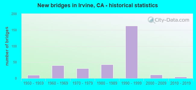
- New bridges - historical statistics
- 11920-1929
- 11930-1939
- 101950-1959
- 401960-1969
- 311970-1979
- 431980-1989
- 1631990-1999
- 112000-2009
- 52010-2019
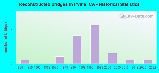
- Reconstructed bridges - Historical Statistics
- 11950-1959
- 01960-1969
- 21970-1979
- 81980-1989
- 111990-1999
- 32000-2009
- 12010-2019
- 12020-2022
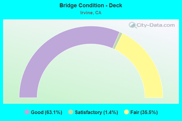
- Bridge Condition - Deck
- 63.1%Good
- 1.4%Satisfactory
- 35.5%Fair
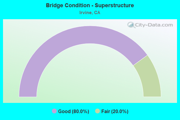
- Bridge Condition - Superstructure
- 80.0%Good
- 20.0%Fair
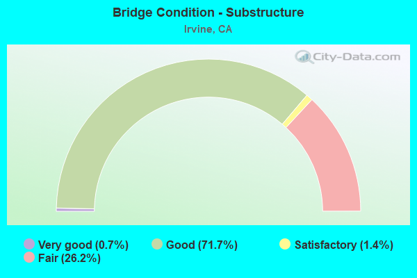
- Bridge Condition - Substructure
- 0.7%Very good
- 71.7%Good
- 1.4%Satisfactory
- 26.2%Fair
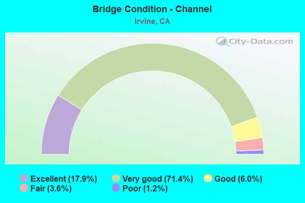
- Bridge Condition - Channel
- 17.9%Excellent
- 71.4%Very good
- 6.0%Good
- 3.6%Fair
- 1.2%Poor
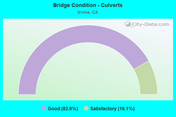
- Bridge Condition - Culverts
- 83.9%Good
- 16.1%Satisfactory
Find on map >> Show street view
Structure Number: 55 0779L, Location: 12-ORA-133-12.55-IRVN (Lat: 33.703947, Lng: -117.728464), Route carried "on" structure: State highway 133, Year Built: 1998, Status: Open, Structure Length: 5.49m (18.01ft), Average Daily Traffic: 25,850 (year 2019), Truck Traffic: 3%, Average Future Daily Traffic: 35,100 (year 2038), Design Load: HS 20+Mod, Features Intersected: PORTOLA PARKWAY
Minimum Vertical Clearance: 30+ m (98+ ft), Kilometerpoint: 12.550, Lanes on structure: 4, Lanes under structure: 4, Base Highway Network: Yes (Inventory Route: 1, Subroute: 1), Owner: State Highway Agency, Approaching Roadway Width: 20.7m (67.9ft), Skew: 1 degrees, Material/Design: Prestressed concrete, Design/Construction: Box Beam or Girders - Multiple, Number Of Spans In Main Unit: 1, Length of Maximum Span: 54.9m (180.1ft), Curb-To-Curb Width: 20.7m (67.9ft), Out-to-Out Width: 21.8m (71.5ft)
Condition: Deck: Fair, Superstructure: Good, Substructure: Good, Operating Rating: 54.1 metric tons, Method Used To Determine Operating Rating: Assigned rating based on Load Factor Design (LFD) reported in metric tons, Inventory Rating: 32.4 metric tons, Method Used To Determine Inventory Rating: Assigned rating based on Load Factor Design (LFD) reported in metric tons, Structural Evaluation: Better than present minimum criteria, Deck Geometry: Equal to present minimum criteria, Underclear: Superior to present desirable criteria, Approach Roadway Alignment: Equal to present desirable criteria, Designated Inspection Frequency: Every 24 months, Inspection Date: January 2021, Deck Structure Type: Concrete Cast-file-Place
Find on map >> Show street view
Structure Number: 55 0779R, Location: 12-ORA-133-12.55-IRVN (Lat: 33.703758, Lng: -117.728019), Route carried "on" structure: State highway 133, Year Built: 1998, Status: Open, Structure Length: 5.60m (18.37ft), Average Daily Traffic: 25,850 (year 2019), Truck Traffic: 3%, Average Future Daily Traffic: 35,100 (year 2038), Design Load: HS 20+Mod, Features Intersected: PORTOLA PARKWAY
Minimum Vertical Clearance: 30+ m (98+ ft), Kilometerpoint: 12.550, Lanes on structure: 4, Lanes under structure: 4, Base Highway Network: Yes (Inventory Route: 1, Subroute: 1), Owner: State Highway Agency, Approaching Roadway Width: 20.7m (67.9ft), Skew: 1 degrees, Material/Design: Prestressed concrete, Design/Construction: Box Beam or Girders - Multiple, Number Of Spans In Main Unit: 1, Length of Maximum Span: 56.0m (183.7ft), Curb-To-Curb Width: 20.7m (67.9ft), Out-to-Out Width: 21.8m (71.5ft)
Condition: Deck: Fair, Superstructure: Good, Substructure: Good, Operating Rating: 54.1 metric tons, Method Used To Determine Operating Rating: Assigned rating based on Load Factor Design (LFD) reported in metric tons, Inventory Rating: 32.4 metric tons, Method Used To Determine Inventory Rating: Assigned rating based on Load Factor Design (LFD) reported in metric tons, Structural Evaluation: Better than present minimum criteria, Deck Geometry: Equal to present minimum criteria, Underclear: Superior to present desirable criteria, Approach Roadway Alignment: Equal to present desirable criteria, Designated Inspection Frequency: Every 24 months, Inspection Date: January 2021, Deck Structure Type: Concrete Cast-file-Place
Find on map >> Show street view
Structure Number: 55 0781G, Location: 12-ORA-133-12.38 (Lat: 33.710356, Lng: -117.721197), Route carried "on" structure: Ramp State highway 133, Year Built: 1998, Status: Open, Structure Length: 5.55m (18.21ft), Average Daily Traffic: 14,288 (year 2015), Truck Traffic: 3%, Average Future Daily Traffic: 22,972 (year 2043), Design Load: HS 20+Mod, Features Intersected: SANTIAGO AQUEDUCT
Minimum Vertical Clearance: 30+ m (98+ ft), Kilometerpoint: 12.380, Lanes on structure: 2, Toll: On toll road, Owner: State Highway Agency, Approaching Roadway Width: 11.9m (39.0ft), Skew: 3 degrees, Material/Design: Prestressed concrete, Design/Construction: Box Beam or Girders - Multiple, Number Of Spans In Main Unit: 1, Length of Maximum Span: 55.5m (182.1ft), Curb-To-Curb Width: 11.9m (39.0ft), Out-to-Out Width: 12.9m (42.3ft)
Condition: Deck: Good, Superstructure: Good, Substructure: Good, Operating Rating: 54.1 metric tons, Method Used To Determine Operating Rating: Assigned rating based on Load Factor Design (LFD) reported in metric tons, Inventory Rating: 32.4 metric tons, Method Used To Determine Inventory Rating: Assigned rating based on Load Factor Design (LFD) reported in metric tons, Structural Evaluation: Better than present minimum criteria, Deck Geometry: Superior to present desirable criteria, Approach Roadway Alignment: Equal to present desirable criteria, Designated Inspection Frequency: Every 24 months, Inspection Date: January 2021, Deck Structure Type: Concrete Cast-file-Place
Find on map >> Show street view
Structure Number: 55 0782G, Location: 12-ORA-241-26.87-IRVN (Lat: 33.710775, Lng: -117.719167), Route carried "on" structure: Ramp State highway 241, Year Built: 1998, Status: Open, Structure Length: 24.45m (80.22ft), Average Daily Traffic: 16,800 (year 2012), Truck Traffic: 3%, Average Future Daily Traffic: 32,706 (year 2040), Design Load: HS 20+Mod, Features Intersected: STATE ROUTE 241
Minimum Vertical Clearance: 30+ m (98+ ft), Kilometerpoint: 26.870, Lanes on structure: 2, Lanes under structure: 4, Owner: State Highway Agency, Approaching Roadway Width: 11.9m (39.0ft), Skew: 9 degrees, Material/Design: Prestressed concrete continuous, Design/Construction: Box Beam or Girders - Multiple, Number Of Spans In Main Unit: 4, Length of Maximum Span: 65.5m (214.9ft), Curb-To-Curb Width: 11.9m (39.0ft), Out-to-Out Width: 13.0m (42.7ft)
Condition: Deck: Good, Superstructure: Good, Substructure: Fair, Operating Rating: 54.1 metric tons, Method Used To Determine Operating Rating: Assigned rating based on Load Factor Design (LFD) reported in metric tons, Inventory Rating: 32.4 metric tons, Method Used To Determine Inventory Rating: Assigned rating based on Load Factor Design (LFD) reported in metric tons, Structural Evaluation: Somewhat better than minimum adequacy, Deck Geometry: Superior to present desirable criteria, Underclear: Better than present minimum criteria, Approach Roadway Alignment: Equal to present desirable criteria, Designated Inspection Frequency: Every 24 months, Inspection Date: Febuary 2021, Deck Structure Type: Concrete Cast-file-Place
Find on map >> Show street view
Structure Number: 55 0783L, Location: 12-ORA-133-13.39-IRVN (Lat: 33.714842, Lng: -117.722550), Route carried "on" structure: State highway 133, Year Built: 1998, Status: Open, Structure Length: 5.40m (17.72ft), Average Daily Traffic: 23,350 (year 2019), Truck Traffic: 3%, Average Future Daily Traffic: 35,100 (year 2038), Design Load: HS 20+Mod, Features Intersected: SANTIAGO AQUEDUCT
Minimum Vertical Clearance: 30+ m (98+ ft), Kilometerpoint: 13.390, Lanes on structure: 2, Base Highway Network: Yes (Inventory Route: 1, Subroute: 1), Owner: State Highway Agency, Approaching Roadway Width: 19.4m (63.6ft), Skew: 3 degrees, Material/Design: Prestressed concrete, Design/Construction: Box Beam or Girders - Multiple, Number Of Spans In Main Unit: 1, Length of Maximum Span: 54.0m (177.2ft), Curb-To-Curb Width: 19.4m (63.6ft), Out-to-Out Width: 20.5m (67.3ft)
Condition: Deck: Fair, Superstructure: Good, Substructure: Good, Channel: Very good, Operating Rating: 54.1 metric tons, Method Used To Determine Operating Rating: Assigned rating based on Load Factor Design (LFD) reported in metric tons, Inventory Rating: 32.4 metric tons, Method Used To Determine Inventory Rating: Assigned rating based on Load Factor Design (LFD) reported in metric tons, Structural Evaluation: Better than present minimum criteria, Deck Geometry: Superior to present desirable criteria, Waterway Adequacy: Equal to present desirable criteria, Approach Roadway Alignment: Equal to present desirable criteria, Designated Inspection Frequency: Every 24 months, Inspection Date: January 2021, Deck Structure Type: Concrete Cast-file-Place
Find on map >> Show street view
Structure Number: 55 0783R, Location: 12-ORA-133-13.37-IRVN (Lat: 33.714347, Lng: -117.722308), Route carried "on" structure: State highway 133, Year Built: 1998, Status: Open, Structure Length: 6.86m (22.51ft), Average Daily Traffic: 23,350 (year 2019), Truck Traffic: 3%, Average Future Daily Traffic: 35,100 (year 2038), Design Load: HS 20+Mod, Features Intersected: SANTIAGO AQUEDUCT
Minimum Vertical Clearance: 30+ m (98+ ft), Kilometerpoint: 13.370, Lanes on structure: 2, Base Highway Network: Yes (Inventory Route: 1, Subroute: 1), Toll: On toll road, Owner: State Highway Agency, Approaching Roadway Width: 17.6m (57.7ft), Skew: 3 degrees, Material/Design: Prestressed concrete, Design/Construction: Box Beam or Girders - Multiple, Number Of Spans In Main Unit: 1, Length of Maximum Span: 68.6m (225.1ft), Curb-To-Curb Width: 17.6m (57.7ft), Out-to-Out Width: 18.7m (61.4ft)
Condition: Deck: Fair, Superstructure: Good, Substructure: Good, Channel: Very good, Operating Rating: 54.1 metric tons, Method Used To Determine Operating Rating: Assigned rating based on Load Factor Design (LFD) reported in metric tons, Inventory Rating: 32.4 metric tons, Method Used To Determine Inventory Rating: Assigned rating based on Load Factor Design (LFD) reported in metric tons, Structural Evaluation: Better than present minimum criteria, Deck Geometry: Superior to present desirable criteria, Waterway Adequacy: Equal to present desirable criteria, Approach Roadway Alignment: Equal to present desirable criteria, Designated Inspection Frequency: Every 24 months, Inspection Date: January 2021, Deck Structure Type: Concrete Cast-file-Place
Find on map >> Show street view
Structure Number: 55 0785, Location: 12-ORA-241-27.39-IRVN (Lat: 33.718028, Lng: -117.721222), Route carried "on" structure: Business City street , Year Built: 1997, Status: Open, Structure Length: 14.39m (47.21ft), Average Daily Traffic: 1,500 (year 2012), Truck Traffic: 20%, Average Future Daily Traffic: 1,971 (year 2040), Design Load: HS 20+Mod, Features Intersected: SR 241 & CONNECTOR, Facility Carried by Structure: BEE CANYON RD
Minimum Vertical Clearance: 30+ m (98+ ft), Kilometerpoint: 0.000, Lanes on structure: 3, Lanes under structure: 6, Owner: State Highway Agency, Approaching Roadway Width: 15.8m (51.8ft), Skew: 2 degrees, Material/Design: Prestressed concrete continuous, Design/Construction: Box Beam or Girders - Multiple, Number Of Spans In Main Unit: 3, Length of Maximum Span: 50.3m (165.0ft), Curb-To-Curb Width: 15.8m (51.8ft), Out-to-Out Width: 16.9m (55.4ft)
Condition: Deck: Good, Superstructure: Good, Substructure: Fair, Operating Rating: 54.1 metric tons, Method Used To Determine Operating Rating: Assigned rating based on Load Factor Design (LFD) reported in metric tons, Inventory Rating: 32.4 metric tons, Method Used To Determine Inventory Rating: Assigned rating based on Load Factor Design (LFD) reported in metric tons, Structural Evaluation: Somewhat better than minimum adequacy, Deck Geometry: Better than present minimum criteria, Underclear: Equal to present minimum criteria, Approach Roadway Alignment: Equal to present desirable criteria, Designated Inspection Frequency: Every 24 months, Inspection Date: Febuary 2021, Deck Structure Type: Concrete Cast-file-Place
Find on map >> Show street view
Structure Number: 55 0822E, Location: 12-ORA-005-20.74-IRVN (Lat: 33.643556, Lng: -117.734178), Route carried "on" structure: Alternate Interstate 5, Year Built: 1996, Status: Open, Structure Length: 68.00m (223.10ft), Average Daily Traffic: 32,000 (year 2019), Truck Traffic: 1%, Average Future Daily Traffic: 38,509 (year 2038), Design Load: HS 20+Mod, Features Intersected: INTERSTATE 5 SB
Minimum Vertical Clearance: 30+ m (98+ ft), Kilometerpoint: 20.740, Lanes on structure: 2, Lanes under structure: 4, Base Highway Network: Yes (, Subroute: 1), Owner: State Highway Agency, Approaching Roadway Width: 15.3m (50.2ft), Skew: 39 degrees, Material/Design: Prestressed concrete continuous, Design/Construction: Box Beam or Girders - Multiple, Number Of Spans In Main Unit: 12, Length of Maximum Span: 62.0m (203.4ft), Curb-To-Curb Width: 15.3m (50.2ft), Out-to-Out Width: 16.3m (53.5ft)
Condition: Deck: Good, Superstructure: Good, Substructure: Good, Operating Rating: 54.1 metric tons, Method Used To Determine Operating Rating: Assigned rating based on Load Factor Design (LFD) reported in metric tons, Inventory Rating: 32.4 metric tons, Method Used To Determine Inventory Rating: Assigned rating based on Load Factor Design (LFD) reported in metric tons, Structural Evaluation: Better than present minimum criteria, Deck Geometry: Superior to present desirable criteria, Underclear: Equal to present minimum criteria, Approach Roadway Alignment: Better than present minimum criteria, Designated Inspection Frequency: Every 24 months, Inspection Date: July 2021, Deck Structure Type: Concrete Cast-file-Place
Find on map >> Show street view
Structure Number: 55 0894K, Location: 12-ORA-073-16.95-LGNB (Lat: 33.592008, Lng: -117.761378), Route carried "on" structure: Ramp State highway 73, Year Built: 1996, Status: Open, Structure Length: 2.40m (7.87ft), Average Daily Traffic: 1,701 (year 2010), Truck Traffic: 1%, Average Future Daily Traffic: 2,041 (year 2040), Design Load: HS 20+Mod, Features Intersected: WILDLIFE PATHWAY
Minimum Vertical Clearance: 30+ m (98+ ft), Kilometerpoint: 16.950, Lanes on structure: 2, Base Highway Network: Yes, Toll: On toll road, Owner: State Highway Agency, Approaching Roadway Width: 11.0m (36.1ft), Material/Design: Prestressed concrete, Design/Construction: Box Beam or Girders - Multiple, Number Of Spans In Main Unit: 1, Length of Maximum Span: 23.0m (75.5ft), Curb-To-Curb Width: 11.0m (36.1ft), Out-to-Out Width: 12.0m (39.4ft)
Condition: Deck: Fair, Superstructure: Fair, Substructure: Good, Operating Rating: 54.1 metric tons, Method Used To Determine Operating Rating: Assigned rating based on Load Factor Design (LFD) reported in metric tons, Inventory Rating: 32.4 metric tons, Method Used To Determine Inventory Rating: Assigned rating based on Load Factor Design (LFD) reported in metric tons, Structural Evaluation: Somewhat better than minimum adequacy, Deck Geometry: Better than present minimum criteria, Approach Roadway Alignment: Equal to present desirable criteria, Designated Inspection Frequency: Every 24 months, Inspection Date: August 2020, Deck Structure Type: Concrete Cast-file-Place
Find on map >> Show street view
Structure Number: 55 0897, Location: 12-ORA-261-0.01-IRVN (Lat: 33.711747, Lng: -117.801358), Route carried "on" structure: City street , Year Built: 1998, Status: Open, Structure Length: 8.35m (27.40ft), Average Daily Traffic: 5,000 (year 2011), Truck Traffic: 3%, Average Future Daily Traffic: 6,017 (year 2043), Design Load: HS 20+Mod, Features Intersected: STATE ROUTE 261, Facility Carried by Structure: WALNUT AVENUE
Minimum Vertical Clearance: 30+ m (98+ ft), Kilometerpoint: 0.000, Lanes on structure: 8, Lanes under structure: 9, Owner: State Highway Agency, Approaching Roadway Width: 41.4m (135.8ft), Material/Design: Prestressed concrete continuous, Design/Construction: Box Beam or Girders - Multiple, Number Of Spans In Main Unit: 2, Length of Maximum Span: 43.3m (142.1ft), Curb or Sidewalk Widths: Left: 1.5m (4.9ft), Right: 1.5m (4.9ft), Curb-To-Curb Width: 41.4m (135.8ft), Out-to-Out Width: 45.1m (148.0ft)
Condition: Deck: Fair, Superstructure: Good, Substructure: Fair, Operating Rating: 54.1 metric tons, Method Used To Determine Operating Rating: Assigned rating based on Load Factor Design (LFD) reported in metric tons, Inventory Rating: 32.4 metric tons, Method Used To Determine Inventory Rating: Assigned rating based on Load Factor Design (LFD) reported in metric tons, Structural Evaluation: Somewhat better than minimum adequacy, Deck Geometry: Superior to present desirable criteria, Underclear: Equal to present minimum criteria, Approach Roadway Alignment: Equal to present desirable criteria, Designated Inspection Frequency: Every 24 months, Inspection Date: Febuary 2021, Deck Structure Type: Concrete Cast-file-Place, Wearing Surface/Protective System: Wearing Surface: Monolithic Concrete
Find on map >> Show street view
Structure Number: 55 0898, Location: 12-ORA-261-0.25-IRVN (Lat: 33.715728, Lng: -117.798764), Route carried "on" structure: Ramp State highway 261, Year Built: 1997, Status: Open, Structure Length: 11.16m (36.61ft), Average Daily Traffic: 19,210 (year 2011), Truck Traffic: 3%, Average Future Daily Traffic: 22,963 (year 2043), Design Load: HS 20+Mod, Features Intersected: S261-WALNUT AVE OFF-RAMP
Minimum Vertical Clearance: 30+ m (98+ ft), Kilometerpoint: 0.250, Lanes on structure: 2, Lanes under structure: 2, Base Highway Network: Yes, Owner: State Highway Agency, Approaching Roadway Width: 11.0m (36.1ft), Skew: 6 degrees, Material/Design: Prestressed concrete continuous, Design/Construction: Box Beam or Girders - Multiple, Number Of Spans In Main Unit: 3, Length of Maximum Span: 46.3m (151.9ft), Curb-To-Curb Width: 11.0m (36.1ft), Out-to-Out Width: 12.0m (39.4ft)
Condition: Deck: Good, Superstructure: Good, Substructure: Fair, Operating Rating: 54.1 metric tons, Method Used To Determine Operating Rating: Assigned rating based on Load Factor Design (LFD) reported in metric tons, Inventory Rating: 32.4 metric tons, Method Used To Determine Inventory Rating: Assigned rating based on Load Factor Design (LFD) reported in metric tons, Structural Evaluation: Somewhat better than minimum adequacy, Deck Geometry: Better than present minimum criteria, Underclear: Equal to present minimum criteria, Approach Roadway Alignment: Equal to present desirable criteria, Designated Inspection Frequency: Every 24 months, Inspection Date: Febuary 2021, Deck Structure Type: Concrete Cast-file-Place
Find on map >> Show street view
Structure Number: 55 0899, Location: 12-ORA-261-0.25-IRVN (Lat: 33.715956, Lng: -117.798358), Route carried "on" structure: City street , Year Built: 1997, Status: Open, Structure Length: 22.30m (73.16ft), Average Daily Traffic: 10,000 (year 2011), Truck Traffic: 3%, Average Future Daily Traffic: 12,035 (year 2043), Design Load: HS 20+Mod, Features Intersected: STATE ROUTE 261, Facility Carried by Structure: JAMBOREE ROAD (NB)
Minimum Vertical Clearance: 30+ m (98+ ft), Kilometerpoint: 0.000, Lanes on structure: 3, Lanes under structure: 6, Owner: State Highway Agency, Approaching Roadway Width: 14.6m (47.9ft), Skew: 4 degrees, Material/Design: Prestressed concrete continuous, Design/Construction: Box Beam or Girders - Multiple, Number Of Spans In Main Unit: 5, Length of Maximum Span: 50.3m (165.0ft), Curb-To-Curb Width: 14.6m (47.9ft), Out-to-Out Width: 15.7m (51.5ft)
Condition: Deck: Fair, Superstructure: Good, Substructure: Fair, Operating Rating: 54.1 metric tons, Method Used To Determine Operating Rating: Assigned rating based on Load Factor Design (LFD) reported in metric tons, Inventory Rating: 32.4 metric tons, Method Used To Determine Inventory Rating: Assigned rating based on Load Factor Design (LFD) reported in metric tons, Structural Evaluation: Somewhat better than minimum adequacy, Deck Geometry: Somewhat better than minimum adequacy, Underclear: Meets minimum limits, Approach Roadway Alignment: Equal to present desirable criteria, Designated Inspection Frequency: Every 24 months, Inspection Date: Febuary 2021, Deck Structure Type: Concrete Cast-file-Place
Find on map >> Show street view
Structure Number: 55 0945E, Location: 12-ORA-405-8.60 (Lat: 33.696964, Lng: -117.863244), Route carried "on" structure: Ramp Interstate 405, Year Built: 2007, Status: Open, Structure Length: 49.60m (162.73ft), Average Daily Traffic: 20,000 (year 2011), Average Future Daily Traffic: 22,369 (year 2038), Design Load: HS 20+Mod, Features Intersected: STATE ROUTE 55 SB, MAIN
Minimum Vertical Clearance: 30+ m (98+ ft), Kilometerpoint: 8.600, Lanes on structure: 2, Lanes under structure: 12, Owner: State Highway Agency, Approaching Roadway Width: 16.6m (54.5ft), Skew: 9 degrees, Material/Design: Prestressed concrete continuous, Design/Construction: Box Beam or Girders - Multiple, Number Of Spans In Main Unit: 7, Length of Maximum Span: 82.0m (269.0ft), Curb-To-Curb Width: 16.6m (54.5ft), Out-to-Out Width: 17.7m (58.1ft)
Condition: Deck: Fair, Superstructure: Good, Substructure: Good, Operating Rating: 54.1 metric tons, Method Used To Determine Operating Rating: Assigned rating based on Load Factor Design (LFD) reported in metric tons, Inventory Rating: 32.4 metric tons, Method Used To Determine Inventory Rating: Assigned rating based on Load Factor Design (LFD) reported in metric tons, Structural Evaluation: Better than present minimum criteria, Deck Geometry: Superior to present desirable criteria, Underclear: Meets minimum limits, Approach Roadway Alignment: Equal to present desirable criteria, Designated Inspection Frequency: Every 24 months, Inspection Date: April 2021, Deck Structure Type: Concrete Cast-file-Place
Find on map >> Show street view
Structure Number: 55 0957, Location: 12-ORA-241-27.05-IRVN (Lat: 33.713108, Lng: -117.720194), Route carried "on" structure: State highway 241, Year Built: 1998, Status: Open, Structure Length: 9.63m (31.59ft), Average Daily Traffic: 48,000 (year 2012), Average Future Daily Traffic: 96,700 (year 2040), Design Load: HS 20+Mod, Features Intersected: WILDLIFE CROSSING
Minimum Vertical Clearance: 30+ m (98+ ft), Kilometerpoint: 27.050, Lanes on structure: 4, Base Highway Network: Yes (Inventory Route: 2, Subroute: 1), Toll: On toll road, Owner: State Highway Agency, Approaching Roadway Width: 23.8m (78.1ft), Material/Design: Steel, Design/Construction: Arch - Deck, Number Of Spans In Main Unit: 1, Length of Maximum Span: 96.3m (315.9ft), Curb-To-Curb Width: 23.8m (78.1ft), Out-to-Out Width: 24.8m (81.4ft)
Condition: Superstructure: Good, Substructure: Good, Operating Rating: 54.1 metric tons, Method Used To Determine Operating Rating: Assigned rating based on Load Factor Design (LFD) reported in metric tons, Inventory Rating: 32.4 metric tons, Method Used To Determine Inventory Rating: Assigned rating based on Load Factor Design (LFD) reported in metric tons, Structural Evaluation: Better than present minimum criteria, Deck Geometry: Superior to present desirable criteria, Approach Roadway Alignment: Equal to present desirable criteria, Designated Inspection Frequency: Every 24 months, Inspection Date: Febuary 2021
Find on map >> Show street view
Structure Number: 55 1054, Location: 12-ORA-022-R7.83-GGR (Lat: 33.767408, Lng: -117.920694), Route carried "on" structure: State highway 22, Year Built: 2008, Status: Open, Structure Length: 5.53m (18.14ft), Average Daily Traffic: 240,000 (year 2020), Truck Traffic: 5%, Average Future Daily Traffic: 257,082 (year 2037), Design Load: HS 20+Mod, Features Intersected: HARBOR BLVD
Minimum Vertical Clearance: 30+ m (98+ ft), Kilometerpoint: 7.830, Lanes on structure: 12, Lanes under structure: 7, Base Highway Network: Yes (, Subroute: 1), Owner: State Highway Agency, Approaching Roadway Width: 57.2m (187.7ft), Skew: 32 degrees, Material/Design: Prestressed concrete, Design/Construction: Girder and Floorbeam System, Number Of Spans In Main Unit: 2, Length of Maximum Span: 30.1m (98.8ft), Curb-To-Curb Width: 57.2m (187.7ft), Out-to-Out Width: 58.5m (191.9ft)
Condition: Deck: Good, Superstructure: Good, Substructure: Good, Operating Rating: 54.1 metric tons, Method Used To Determine Operating Rating: Assigned rating based on Load Factor Design (LFD) reported in metric tons, Inventory Rating: 32.4 metric tons, Method Used To Determine Inventory Rating: Assigned rating based on Load Factor Design (LFD) reported in metric tons, Structural Evaluation: Better than present minimum criteria, Deck Geometry: Superior to present desirable criteria, Underclear: Meets minimum limits, Approach Roadway Alignment: Equal to present desirable criteria, Designated Inspection Frequency: Every 48 months, Inspection Date: April 2020, Deck Structure Type: Concrete Cast-file-Place
Find on map >> Show street view
Structure Number: 55C0038, Location: 0.2 MI W/O SILVERADO CYN (Lat: 33.747661, Lng: -117.676100), Route carried "on" structure: County highway , Year Built: 1963, Status: Open, Structure Length: 6.95m (22.80ft), Average Daily Traffic: 7,000 (year 2021), Truck Traffic: 5%, Average Future Daily Traffic: 9,619 (year 2039), Design Load: HS 20, Features Intersected: SANTIAGO CREEK, Facility Carried by Structure: SANTIAGO CNYN ROAD
Minimum Vertical Clearance: 30+ m (98+ ft), Kilometerpoint: 0.000, Lanes on structure: 2, Base Highway Network: Yes, Owner: County Highway Agency, Approaching Roadway Width: 12.2m (40.0ft), Material/Design: Concrete continuous, Design/Construction: Tee Beam, Number Of Spans In Main Unit: 4, Length of Maximum Span: 19.2m (63.0ft), Curb-To-Curb Width: 8.5m (27.9ft), Out-to-Out Width: 9.3m (30.5ft)
Condition: Deck: Good, Superstructure: Good, Substructure: Good, Channel: Poor, Operating Rating: 39.5 metric tons, Method Used To Determine Operating Rating: Load and Resistance Factor Rating (LRFR) rating reported by rating factor(RF) method using HL-93 loadings, Inventory Rating: 30.5 metric tons, Method Used To Determine Inventory Rating: Load and Resistance Factor Rating (LRFR) rating reported by rating factor(RF) method using HL-93 loadings, Structural Evaluation: Better than present minimum criteria, Deck Geometry: Meets minimum limits, Waterway Adequacy: Equal to present desirable criteria, Approach Roadway Alignment: Equal to present minimum criteria, Designated Inspection Frequency: Every 24 months, Inspection Date: May 2021, Deck Structure Type: Concrete Cast-file-Place
Find on map >> Show street view
Structure Number: 55C0065, Location: 4.4 MI SE/O JAMBOREE RD. (Lat: 33.760025, Lng: -117.703464), Route carried "on" structure: County highway , Year Built: 1931, Year Reconstructed: 1955, Status: Open, Structure Length: 0.79m (2.59ft), Average Daily Traffic: 8,000 (year 2021), Truck Traffic: 3%, Average Future Daily Traffic: 12,426 (year 2038), Features Intersected: LIMESTONE CANYON, Facility Carried by Structure: SANTIAGO CNYN ROAD
Minimum Vertical Clearance: 30+ m (98+ ft), Kilometerpoint: 0.000, Lanes on structure: 2, Base Highway Network: Yes, Owner: County Highway Agency, Approaching Roadway Width: 12.5m (41.0ft), Material/Design: Concrete, Design/Construction: Culvert, Number Of Spans In Main Unit: 2, Length of Maximum Span: 3.7m (12.1ft), Curb-To-Curb Width: 12.5m (41.0ft), Out-to-Out Width: 12.8m (42.0ft)
Condition: Channel: Very good, Culverts: Good, Operating Rating: 27.2 metric tons, Method Used To Determine Operating Rating: Field evaluation and documented engineering judgment, Inventory Rating: 16.2 metric tons, Method Used To Determine Inventory Rating: Field evaluation and documented engineering judgment, Structural Evaluation: Meets minimum limits, Deck Geometry: Somewhat better than minimum adequacy, Waterway Adequacy: Equal to present desirable criteria, Approach Roadway Alignment: Equal to present desirable criteria, Designated Inspection Frequency: Every 24 months, Inspection Date: May 2021
Find on map >> Show street view
Structure Number: 55C0201, Location: 50' N/O MELROSE STREET (Lat: 33.862006, Lng: -118.002406), Route carried "on" structure: City street , Year Built: 1958, Status: Open, Structure Length: 1.10m (3.61ft), Average Daily Traffic: 22,000 (year 2020), Truck Traffic: 1%, Average Future Daily Traffic: 35,000 (year 2040), Design Load: HS 20, Features Intersected: FULLERTON CREEK CHANNEL, Facility Carried by Structure: WESTERN AVENUE
Minimum Vertical Clearance: 30+ m (98+ ft), Kilometerpoint: 0.000, Lanes on structure: 5, Owner: City or Municipal Highway Agency, Approaching Roadway Width: 19.2m (63.0ft), Material/Design: Prestressed concrete, Design/Construction: Slab, Number Of Spans In Main Unit: 1, Length of Maximum Span: 10.7m (35.1ft), Curb or Sidewalk Widths: Left: 1.1m (3.6ft), Right: 1.2m (3.9ft), Curb-To-Curb Width: 19.2m (63.0ft), Out-to-Out Width: 22.2m (72.8ft)
Condition: Deck: Good, Superstructure: Good, Substructure: Very good, Channel: Excellent, Operating Rating: 57.3 metric tons, Method Used To Determine Operating Rating: Load Factor (LF), Inventory Rating: 32.4 metric tons, Method Used To Determine Inventory Rating: Load Factor (LF), Structural Evaluation: Better than present minimum criteria, Deck Geometry: Meets minimum limits, Waterway Adequacy: Superior to present desirable criteria, Approach Roadway Alignment: Equal to present desirable criteria, Designated Inspection Frequency: Every 48 months, Inspection Date: April 2020, Deck Structure Type: Concrete Precast Panels, Wearing Surface/Protective System: Wearing Surface: Bituminous
Find on map >> Show street view
Structure Number: 55C0203, Location: 0.3 KM W HARVARD AVE (Lat: 33.670494, Lng: -117.836467), Route carried "on" structure: City street , Year Built: 1976, Year Reconstructed: 1997, Status: Open, Structure Length: 10.79m (35.40ft), Average Daily Traffic: 17,700 (year 2018), Truck Traffic: 7%, Average Future Daily Traffic: 30,000 (year 2040), Design Load: HS 20+Mod, Features Intersected: SAN DIEGO CREEK CHANNEL, Facility Carried by Structure: MICHELSON DRIVE
Minimum Vertical Clearance: 30+ m (98+ ft), Kilometerpoint: 0.000, Lanes on structure: 4, Owner: City or Municipal Highway Agency, Approaching Roadway Width: 22.9m (75.1ft), Material/Design: Prestressed concrete continuous, Design/Construction: Stringer/Multi-beam, Number Of Spans In Main Unit: 4, Length of Maximum Span: 26.8m (87.9ft), Curb or Sidewalk Widths: Left: 1.5m (4.9ft), Right: 1.5m (4.9ft), Curb-To-Curb Width: 22.9m (75.1ft), Out-to-Out Width: 26.6m (87.3ft)
Condition: Deck: Good, Superstructure: Good, Substructure: Good, Channel: Very good, Operating Rating: 54.1 metric tons, Method Used To Determine Operating Rating: Assigned rating based on Load Factor Design (LFD) reported in metric tons, Inventory Rating: 32.4 metric tons, Method Used To Determine Inventory Rating: Assigned rating based on Load Factor Design (LFD) reported in metric tons, Structural Evaluation: Better than present minimum criteria, Deck Geometry: Superior to present desirable criteria, Waterway Adequacy: Superior to present desirable criteria, Approach Roadway Alignment: Equal to present desirable criteria, Designated Inspection Frequency: Every 48 months, Inspection Date: Febuary 2022, Deck Structure Type: Concrete Cast-file-Place
Find on map >> Show street view
Structure Number: 55C0204, Location: 50' E HARVARD AVE (Lat: 33.670411, Lng: -117.833147), Route carried "on" structure: City street , Year Built: 1950, Year Reconstructed: 1981, Status: Open, Structure Length: 2.32m (7.61ft), Average Daily Traffic: 15,500 (year 2018), Truck Traffic: 7%, Average Future Daily Traffic: 25,132 (year 2038), Design Load: HS 20, Features Intersected: SAN JOAQUIN CHANNEL, Facility Carried by Structure: MICHELSON DR
Minimum Vertical Clearance: 30+ m (98+ ft), Kilometerpoint: 0.000, Lanes on structure: 5, Owner: City or Municipal Highway Agency, Approaching Roadway Width: 19.8m (65.0ft), Material/Design: Concrete continuous, Design/Construction: Slab, Number Of Spans In Main Unit: 2, Length of Maximum Span: 11.6m (38.1ft), Curb or Sidewalk Widths: Left: 1.6m (5.2ft), Right: 1.6m (5.2ft), Curb-To-Curb Width: 19.8m (65.0ft), Out-to-Out Width: 23.8m (78.1ft)
Condition: Deck: Good, Superstructure: Good, Substructure: Good, Channel: Very good, Operating Rating: 97.5 metric tons, Method Used To Determine Operating Rating: Load Factor (LF), Inventory Rating: 58.6 metric tons, Method Used To Determine Inventory Rating: Load Factor (LF), Structural Evaluation: Better than present minimum criteria, Deck Geometry: Meets minimum limits, Waterway Adequacy: Equal to present desirable criteria, Approach Roadway Alignment: Equal to present desirable criteria, Designated Inspection Frequency: Every 48 months, Inspection Date: July 2020, Deck Structure Type: Concrete Cast-file-Place, Wearing Surface/Protective System: Wearing Surface: Bituminous
Find on map >> Show street view
Structure Number: 55C033, Location: 0.2 MI. N/O LAMBERT ROAD (Lat: 33.927606, Lng: -117.946008), Route carried "on" structure: City street , Year Built: 1978, Status: Open, Structure Length: 0.91m (2.99ft), Average Daily Traffic: 14,000 (year 2013), Truck Traffic: 1%, Average Future Daily Traffic: 27,241 (year 2037), Features Intersected: COYOTE CREEK CHANNEL, Facility Carried by Structure: EUCLID STREET
Minimum Vertical Clearance: 30+ m (98+ ft), Kilometerpoint: 0.000, Lanes on structure: 4, Owner: City or Municipal Highway Agency, Approaching Roadway Width: 19.5m (64.0ft), Skew: 9 degrees, Material/Design: Concrete, Design/Construction: Culvert, Number Of Spans In Main Unit: 2, Length of Maximum Span: 4.3m (14.1ft), Curb or Sidewalk Widths: Left: 1.8m (5.9ft), Right: 2.3m (7.5ft), Curb-To-Curb Width: 19.5m (64.0ft), Out-to-Out Width: 24.4m (80.1ft)
Condition: Channel: Excellent, Culverts: Good, Operating Rating: 54.1 metric tons, Method Used To Determine Operating Rating: Field evaluation and documented engineering judgment, Inventory Rating: 32.4 metric tons, Method Used To Determine Inventory Rating: Field evaluation and documented engineering judgment, Structural Evaluation: Better than present minimum criteria, Deck Geometry: Better than present minimum criteria, Waterway Adequacy: Superior to present desirable criteria, Approach Roadway Alignment: Equal to present desirable criteria, Designated Inspection Frequency: Every 48 months, Inspection Date: October 2019
Find on map >> Show street view
Structure Number: 55C0336, Location: 0.2 MI W JAMBOREE RD (Lat: 33.719450, Lng: -117.799256), Route carried "on" structure: City street , Year Built: 1974, Year Reconstructed: 1999, Status: Open, Structure Length: 2.00m (6.56ft), Average Daily Traffic: 10,500 (year 2018), Truck Traffic: 7%, Average Future Daily Traffic: 11,000 (year 2040), Design Load: HS 20, Features Intersected: EL MODENA IRVINE CHANNEL, Facility Carried by Structure: MICHELLE DRIVE
Minimum Vertical Clearance: 30+ m (98+ ft), Kilometerpoint: 0.000, Lanes on structure: 4, Owner: City or Municipal Highway Agency, Approaching Roadway Width: 25.6m (84.0ft), Skew: 2 degrees, Material/Design: Prestressed concrete, Design/Construction: Stringer/Multi-beam, Number Of Spans In Main Unit: 1, Length of Maximum Span: 19.4m (63.6ft), Curb or Sidewalk Widths: Left: 1.5m (4.9ft), Right: 1.5m (4.9ft), Curb-To-Curb Width: 25.6m (84.0ft), Out-to-Out Width: 29.2m (95.8ft)
Condition: Deck: Good, Superstructure: Good, Substructure: Good, Channel: Excellent, Operating Rating: 54.1 metric tons, Method Used To Determine Operating Rating: Field evaluation and documented engineering judgment, Inventory Rating: 32.4 metric tons, Method Used To Determine Inventory Rating: Field evaluation and documented engineering judgment, Structural Evaluation: Better than present minimum criteria, Deck Geometry: Superior to present desirable criteria, Waterway Adequacy: Equal to present desirable criteria, Approach Roadway Alignment: Equal to present desirable criteria, Designated Inspection Frequency: Every 48 months, Inspection Date: March 2022, Deck Structure Type: Concrete Cast-file-Place
Find on map >> Show street view
Structure Number: 55C0339L, Location: 0.3 MI E JAMBOREE RD (Lat: 33.679142, Lng: -117.835619), Route carried "on" structure: City street , Year Built: 1969, Year Reconstructed: 1988, Status: Open, Structure Length: 8.06m (26.44ft), Average Daily Traffic: 8,700 (year 2018), Truck Traffic: 7%, Average Future Daily Traffic: 9,800 (year 2040), Design Load: HS 20, Features Intersected: SAN DIEGO CREEK CHANNEL, Facility Carried by Structure: MAIN STREET W/B
Minimum Vertical Clearance: 30+ m (98+ ft), Kilometerpoint: 0.000, Lanes on structure: 3, Owner: City or Municipal Highway Agency, Approaching Roadway Width: 12.2m (40.0ft), Material/Design: Concrete continuous, Design/Construction: Tee Beam, Number Of Spans In Main Unit: 5, Length of Maximum Span: 17.7m (58.1ft), Curb or Sidewalk Widths: Left: 1.5m (4.9ft), Right: 0.0m, Curb-To-Curb Width: 14.3m (46.9ft), Out-to-Out Width: 16.5m (54.1ft)
Condition: Deck: Satisfactory, Superstructure: Good, Substructure: Good, Channel: Very good, Operating Rating: 32.7 metric tons, Method Used To Determine Operating Rating: Load and Resistance Factor Rating (LRFR) rating reported by rating factor(RF) method using HL-93 loadings, Inventory Rating: 23.3 metric tons, Method Used To Determine Inventory Rating: Load and Resistance Factor Rating (LRFR) rating reported by rating factor(RF) method using HL-93 loadings, Structural Evaluation: Somewhat better than minimum adequacy, Deck Geometry: Somewhat better than minimum adequacy, Waterway Adequacy: Equal to present desirable criteria, Approach Roadway Alignment: Equal to present desirable criteria, Designated Inspection Frequency: Every 24 months, Inspection Date: July 2020, Deck Structure Type: Concrete Cast-file-Place
Find on map >> Show street view
Structure Number: 55C0339R, Location: 0.3 MI E JAMBOREE RD (Lat: 33.679006, Lng: -117.835683), Route carried "on" structure: City street , Year Built: 1988, Status: Open, Structure Length: 8.06m (26.44ft), Average Daily Traffic: 12,900 (year 2018), Truck Traffic: 7%, Average Future Daily Traffic: 14,500 (year 2040), Design Load: HS 20+Mod, Features Intersected: SAN DIEGO CREEK CHANNEL, Facility Carried by Structure: MAIN STREET E/B
Minimum Vertical Clearance: 30+ m (98+ ft), Kilometerpoint: 0.000, Lanes on structure: 3, Owner: City or Municipal Highway Agency, Approaching Roadway Width: 12.2m (40.0ft), Material/Design: Concrete continuous, Design/Construction: Tee Beam, Number Of Spans In Main Unit: 5, Length of Maximum Span: 17.7m (58.1ft), Curb or Sidewalk Widths: Left: 0.0m, Right: 1.5m (4.9ft), Curb-To-Curb Width: 11.9m (39.0ft), Out-to-Out Width: 14.3m (46.9ft)
Condition: Deck: Good, Superstructure: Good, Substructure: Good, Channel: Very good, Operating Rating: 54.1 metric tons, Method Used To Determine Operating Rating: Assigned rating based on Load Factor Design (LFD) reported in metric tons, Inventory Rating: 32.4 metric tons, Method Used To Determine Inventory Rating: Assigned rating based on Load Factor Design (LFD) reported in metric tons, Structural Evaluation: Better than present minimum criteria, Deck Geometry: High priority of corrective action, Waterway Adequacy: Superior to present desirable criteria, Approach Roadway Alignment: Equal to present desirable criteria, Designated Inspection Frequency: Every 48 months, Inspection Date: July 2018, Deck Structure Type: Concrete Cast-file-Place
Find on map >> Show street view
Structure Number: 55C0342R, Location: 0.2 MI E JAMBOREE RD (Lat: 33.691536, Lng: -117.823372), Route carried "on" structure: City street , Year Built: 1978, Status: Open, Structure Length: 4.11m (13.48ft), Average Daily Traffic: 10,500 (year 2018), Truck Traffic: 7%, Average Future Daily Traffic: 13,000 (year 2040), Design Load: HS 20, Features Intersected: PETERS CANYON CHANNEL, Facility Carried by Structure: BARANCA PKWY EB
Minimum Vertical Clearance: 30+ m (98+ ft), Kilometerpoint: 0.000, Lanes on structure: 3, Owner: City or Municipal Highway Agency, Approaching Roadway Width: 13.1m (43.0ft), Skew: 1 degrees, Material/Design: Concrete continuous, Design/Construction: Tee Beam, Number Of Spans In Main Unit: 3, Length of Maximum Span: 16.2m (53.1ft), Curb or Sidewalk Widths: Left: 1.5m (4.9ft), Right: 0.0m, Curb-To-Curb Width: 13.1m (43.0ft), Out-to-Out Width: 15.2m (49.9ft)
Condition: Deck: Good, Superstructure: Good, Substructure: Good, Channel: Very good, Operating Rating: 63.2 metric tons, Method Used To Determine Operating Rating: Load Factor (LF), Inventory Rating: 37.9 metric tons, Method Used To Determine Inventory Rating: Load Factor (LF), Structural Evaluation: Better than present minimum criteria, Deck Geometry: Meets minimum limits, Waterway Adequacy: Superior to present desirable criteria, Approach Roadway Alignment: Equal to present desirable criteria, Designated Inspection Frequency: Every 48 months, Inspection Date: November 2021, Deck Structure Type: Concrete Cast-file-Place
Find on map >> Show street view
Structure Number: 55C035, Location: 0.2 MI. N/O CRESCENT AVE. (Lat: 33.841639, Lng: -117.947272), Route carried "on" structure: City street , Year Built: 1960, Status: Open, Structure Length: 1.10m (3.61ft), Average Daily Traffic: 2,500 (year 2006), Truck Traffic: 1%, Average Future Daily Traffic: 2,254 (year 2043), Design Load: HS 20, Features Intersected: CARBON CREEK CHANNEL, Facility Carried by Structure: CHIPPEWA AVENUE
Minimum Vertical Clearance: 30+ m (98+ ft), Kilometerpoint: 0.000, Lanes on structure: 2, Owner: City or Municipal Highway Agency, Approaching Roadway Width: 12.2m (40.0ft), Material/Design: Prestressed concrete, Design/Construction: Slab, Number Of Spans In Main Unit: 1, Length of Maximum Span: 10.7m (35.1ft), Curb or Sidewalk Widths: Left: 1.3m (4.3ft), Right: 1.3m (4.3ft), Curb-To-Curb Width: 7.9m (25.9ft), Out-to-Out Width: 11.0m (36.1ft)
Condition: Deck: Good, Superstructure: Good, Substructure: Good, Channel: Very good, Operating Rating: 59.6 metric tons, Method Used To Determine Operating Rating: Load Factor (LF), Inventory Rating: 35.6 metric tons, Method Used To Determine Inventory Rating: Load Factor (LF), Structural Evaluation: Better than present minimum criteria, Deck Geometry: High priority of corrective action, Waterway Adequacy: Superior to present desirable criteria, Approach Roadway Alignment: Equal to present desirable criteria, Designated Inspection Frequency: Every 48 months, Inspection Date: September 2021, Deck Structure Type: Concrete Precast Panels, Wearing Surface/Protective System: Wearing Surface: Bituminous
Find on map >> Show street view
Structure Number: 55C0357, Location: 0.2 MI S BARRANCA PKY (Lat: 33.682017, Lng: -117.810089), Route carried "on" structure: City street , Year Built: 1971, Status: Open, Structure Length: 1.70m (5.58ft), Average Daily Traffic: 47,700 (year 2018), Truck Traffic: 7%, Average Future Daily Traffic: 54,800 (year 2040), Design Load: HS 20, Features Intersected: SAN DIEGO CREEK CHANNEL, Facility Carried by Structure: CULVER DRIVE
Minimum Vertical Clearance: 30+ m (98+ ft), Kilometerpoint: 0.000, Lanes on structure: 6, Base Highway Network: Yes, Owner: City or Municipal Highway Agency, Approaching Roadway Width: 24.4m (80.1ft), Skew: 30 degrees, Material/Design: Prestressed concrete, Design/Construction: Slab, Number Of Spans In Main Unit: 1, Length of Maximum Span: 16.6m (54.5ft), Curb or Sidewalk Widths: Left: 1.5m (4.9ft), Right: 1.5m (4.9ft), Curb-To-Curb Width: 24.4m (80.1ft), Out-to-Out Width: 34.1m (111.9ft)
Condition: Deck: Good, Superstructure: Good, Substructure: Good, Channel: Very good, Operating Rating: 27.9 metric tons, Method Used To Determine Operating Rating: Field evaluation and documented engineering judgment, Inventory Rating: 16.8 metric tons, Method Used To Determine Inventory Rating: Field evaluation and documented engineering judgment, Structural Evaluation: Meets minimum limits, Deck Geometry: Somewhat better than minimum adequacy, Waterway Adequacy: Equal to present desirable criteria, Approach Roadway Alignment: Equal to present desirable criteria, Designated Inspection Frequency: Every 24 months, Inspection Date: November 2020, Deck Structure Type: Concrete Cast-file-Place, Wearing Surface/Protective System: Wearing Surface: Bituminous
Find on map >> Show street view
Structure Number: 55C0362, Location: 100' N/E MCARTHUR BLVD (Lat: 33.693781, Lng: -117.854486), Route carried "on" structure: City street , Year Built: 1950, Status: Open, Structure Length: 1.10m (3.61ft), Average Daily Traffic: 38,200 (year 2018), Truck Traffic: 7%, Average Future Daily Traffic: 45,500 (year 2040), Features Intersected: LANE CHANNEL, Facility Carried by Structure: RED HILL AVENUE
Minimum Vertical Clearance: 30+ m (98+ ft), Kilometerpoint: 0.000, Lanes on structure: 10, Base Highway Network: Yes, Owner: City or Municipal Highway Agency, Approaching Roadway Width: 44.0m (144.4ft), Skew: 1 degrees, Material/Design: Concrete, Design/Construction: Culvert, Number Of Spans In Main Unit: 3, Length of Maximum Span: 3.4m (11.2ft), Curb or Sidewalk Widths: Left: 0.2m (0.7ft), Right: 0.2m (0.7ft), Curb-To-Curb Width: 45.0m (147.6ft), Out-to-Out Width: 58.5m (191.9ft)
Condition: Channel: Very good, Culverts: Good, Operating Rating: 40.5 metric tons, Method Used To Determine Operating Rating: Field evaluation and documented engineering judgment, Inventory Rating: 24.3 metric tons, Method Used To Determine Inventory Rating: Field evaluation and documented engineering judgment, Structural Evaluation: Equal to present minimum criteria, Deck Geometry: Superior to present desirable criteria, Waterway Adequacy: Equal to present desirable criteria, Approach Roadway Alignment: Equal to present desirable criteria, Designated Inspection Frequency: Every 24 months, Inspection Date: November 2020
Find on map >> Show street view
Structure Number: 55C0393, Location: 100' NW UNIVERSITY DR (Lat: 33.655689, Lng: -117.845892), Route carried "on" structure: City street , Year Built: 1974, Status: Open, Structure Length: 11.04m (36.22ft), Average Daily Traffic: 17,000 (year 2018), Truck Traffic: 7%, Average Future Daily Traffic: 30,000 (year 2040), Design Load: HS 20, Features Intersected: SAN DIEGO CREEK CHANNEL, Facility Carried by Structure: CAMPUS DRIVE
Minimum Vertical Clearance: 30+ m (98+ ft), Kilometerpoint: 0.000, Lanes on structure: 3, Owner: City or Municipal Highway Agency, Approaching Roadway Width: 22.9m (75.1ft), Material/Design: Concrete continuous, Design/Construction: Tee Beam, Number Of Spans In Main Unit: 6, Length of Maximum Span: 19.8m (65.0ft), Curb or Sidewalk Widths: Left: 0.0m, Right: 2.1m (6.9ft), Curb-To-Curb Width: 22.9m (75.1ft), Out-to-Out Width: 25.6m (84.0ft)
Condition: Deck: Good, Superstructure: Good, Substructure: Good, Channel: Very good, Operating Rating: 40.2 metric tons, Method Used To Determine Operating Rating: Load and Resistance Factor Rating (LRFR) rating reported by rating factor(RF) method using HL-93 loadings, Inventory Rating: 31.1 metric tons, Method Used To Determine Inventory Rating: Load and Resistance Factor Rating (LRFR) rating reported by rating factor(RF) method using HL-93 loadings, Structural Evaluation: Better than present minimum criteria, Deck Geometry: Superior to present desirable criteria, Waterway Adequacy: Equal to present desirable criteria, Approach Roadway Alignment: Equal to present desirable criteria, Designated Inspection Frequency: Every 24 months, Inspection Date: Febuary 2022, Deck Structure Type: Concrete Cast-file-Place
Find on map >> Show street view
Structure Number: 55C0394, Location: 100' S UNIVERSITY DR (Lat: 33.657075, Lng: -117.827600), Route carried "on" structure: City street , Year Built: 1970, Year Reconstructed: 2020, Status: Open, Structure Length: 0.76m (2.49ft), Average Daily Traffic: 46,300 (year 2018), Truck Traffic: 7%, Average Future Daily Traffic: 50,900 (year 2040), Features Intersected: SAND CANYON CHANNEL, Facility Carried by Structure: CULVER DRIVE
Minimum Vertical Clearance: 30+ m (98+ ft), Kilometerpoint: 0.000, Lanes on structure: 7, Base Highway Network: Yes, Owner: City or Municipal Highway Agency, Approaching Roadway Width: 29.5m (96.8ft), Skew: 30 degrees, Material/Design: Concrete, Design/Construction: Culvert, Number Of Spans In Main Unit: 2, Length of Maximum Span: 3.7m (12.1ft), Curb or Sidewalk Widths: Left: 2.7m (8.9ft), Right: 2.4m (7.9ft), Curb-To-Curb Width: 29.5m (96.8ft), Out-to-Out Width: 45.7m (149.9ft)
Condition: Channel: Fair, Culverts: Good, Operating Rating: 40.5 metric tons, Method Used To Determine Operating Rating: Field evaluation and documented engineering judgment, Inventory Rating: 24.3 metric tons, Method Used To Determine Inventory Rating: Field evaluation and documented engineering judgment, Structural Evaluation: Equal to present minimum criteria, Deck Geometry: Somewhat better than minimum adequacy, Waterway Adequacy: Equal to present desirable criteria, Approach Roadway Alignment: Equal to present desirable criteria, Designated Inspection Frequency: Every 24 months, Inspection Date: Febuary 2022
Find on map >> Show street view
Structure Number: 55C0416, Location: 250' WEST HARVARD AVE (Lat: 33.657600, Lng: -117.839856), Route carried "on" structure: City street , Year Built: 1950, Year Reconstructed: 1981, Status: Open, Structure Length: 1.46m (4.79ft), Average Daily Traffic: 27,700 (year 2018), Truck Traffic: 7%, Average Future Daily Traffic: 33,600 (year 2040), Features Intersected: SAND CANYON CHANNEL, Facility Carried by Structure: UNIVERSITY DRIVE
Minimum Vertical Clearance: 30+ m (98+ ft), Kilometerpoint: 0.000, Lanes on structure: 7, Base Highway Network: Yes, Owner: City or Municipal Highway Agency, Approaching Roadway Width: 28.0m (91.9ft), Skew: 35 degrees, Material/Design: Concrete, Design/Construction: Culvert, Number Of Spans In Main Unit: 2, Length of Maximum Span: 3.7m (12.1ft), Curb-To-Curb Width: 28.0m (91.9ft), Out-to-Out Width: 33.3m (109.3ft)
Condition: Channel: Very good, Culverts: Good, Operating Rating: 40.5 metric tons, Method Used To Determine Operating Rating: Field evaluation and documented engineering judgment, Inventory Rating: 24.3 metric tons, Method Used To Determine Inventory Rating: Field evaluation and documented engineering judgment, Structural Evaluation: Equal to present minimum criteria, Deck Geometry: Somewhat better than minimum adequacy, Waterway Adequacy: Superior to present desirable criteria, Approach Roadway Alignment: Equal to present desirable criteria, Designated Inspection Frequency: Every 24 months, Inspection Date: Febuary 2022
Find on map >> Show street view
Structure Number: 55C043, Location: 0.5 MI S/O WARNER AVE (Lat: 33.708289, Lng: -118.032408), Route carried "on" structure: City street , Year Built: 1970, Status: Open, Structure Length: 0.76m (2.49ft), Average Daily Traffic: 8,000 (year 2018), Truck Traffic: 1%, Average Future Daily Traffic: 8,965 (year 2040), Design Load: H 15, Features Intersected: SLATER AVE CHANNEL, Facility Carried by Structure: GRAHAM STREET
Minimum Vertical Clearance: 30+ m (98+ ft), Kilometerpoint: 0.000, Lanes on structure: 2, Owner: City or Municipal Highway Agency, Approaching Roadway Width: 19.2m (63.0ft), Material/Design: Concrete, Design/Construction: Culvert, Number Of Spans In Main Unit: 2, Length of Maximum Span: 3.7m (12.1ft), Curb or Sidewalk Widths: Left: 2.4m (7.9ft), Right: 2.4m (7.9ft), Curb-To-Curb Width: 19.2m (63.0ft), Out-to-Out Width: 30.4m (99.7ft)
Condition: Channel: Excellent, Culverts: Good, Operating Rating: 40.5 metric tons, Method Used To Determine Operating Rating: Field evaluation and documented engineering judgment, Inventory Rating: 24.3 metric tons, Method Used To Determine Inventory Rating: Field evaluation and documented engineering judgment, Structural Evaluation: Equal to present minimum criteria, Deck Geometry: Superior to present desirable criteria, Waterway Adequacy: Superior to present desirable criteria, Approach Roadway Alignment: Equal to present desirable criteria, Designated Inspection Frequency: Every 24 months, Inspection Date: April 2020
Find on map >> Show street view
Structure Number: 55C0436, Location: 0.2 MI SW BARRANCA PARKY (Lat: 33.680614, Lng: -117.807933), Route carried "on" structure: City street , Year Built: 1979, Status: Open, Structure Length: 8.54m (28.02ft), Average Daily Traffic: 5,500 (year 2018), Truck Traffic: 7%, Average Future Daily Traffic: 6,700 (year 2040), Design Load: HS 20, Features Intersected: SAN DIEGO CREEK CHANNEL, Facility Carried by Structure: WEST YALE LOOP
Minimum Vertical Clearance: 30+ m (98+ ft), Kilometerpoint: 0.000, Lanes on structure: 4, Owner: City or Municipal Highway Agency, Approaching Roadway Width: 24.1m (79.1ft), Skew: 3 degrees, Material/Design: Concrete continuous, Design/Construction: Box Beam or Girders - Multiple, Number Of Spans In Main Unit: 3, Length of Maximum Span: 33.8m (110.9ft), Curb or Sidewalk Widths: Left: 1.5m (4.9ft), Right: 1.5m (4.9ft), Curb-To-Curb Width: 19.6m (64.3ft), Out-to-Out Width: 23.2m (76.1ft)
Condition: Deck: Good, Superstructure: Good, Substructure: Good, Channel: Very good, Operating Rating: 99.8 metric tons, Method Used To Determine Operating Rating: Load Factor (LF), Inventory Rating: 78.4 metric tons, Method Used To Determine Inventory Rating: Load Factor (LF), Structural Evaluation: Better than present minimum criteria, Deck Geometry: Better than present minimum criteria, Waterway Adequacy: Equal to present desirable criteria, Approach Roadway Alignment: Equal to present desirable criteria, Designated Inspection Frequency: Every 24 months, Inspection Date: November 2020, Deck Structure Type: Concrete Cast-file-Place
Find on map >> Show street view
Structure Number: 55C0437, Location: 0.1 MI S BARRANCA PKWY (Lat: 33.672383, Lng: -117.785883), Route carried "on" structure: City street , Year Built: 1957, Year Reconstructed: 1980, Status: Open, Structure Length: 2.68m (8.79ft), Average Daily Traffic: 43,700 (year 2018), Truck Traffic: 7%, Average Future Daily Traffic: 43,900 (year 2040), Design Load: HS 20, Features Intersected: WOODBRIDGE BICYCLE TRAIL, Facility Carried by Structure: JEFFREY ROAD
Minimum Vertical Clearance: 30+ m (98+ ft), Kilometerpoint: 0.000, Lanes on structure: 6, Base Highway Network: Yes, Owner: City or Municipal Highway Agency, Approaching Roadway Width: 24.4m (80.1ft), Skew: 33 degrees, Material/Design: Concrete continuous, Design/Construction: Slab, Number Of Spans In Main Unit: 3, Length of Maximum Span: 10.4m (34.1ft), Curb or Sidewalk Widths: Left: 1.5m (4.9ft), Right: 3.0m (9.8ft), Curb-To-Curb Width: 24.4m (80.1ft), Out-to-Out Width: 36.3m (119.1ft)
Condition: Deck: Good, Superstructure: Good, Substructure: Good, Operating Rating: 33.4 metric tons, Method Used To Determine Operating Rating: Field evaluation and documented engineering judgment, Inventory Rating: 20.1 metric tons, Method Used To Determine Inventory Rating: Field evaluation and documented engineering judgment, Structural Evaluation: Somewhat better than minimum adequacy, Deck Geometry: Somewhat better than minimum adequacy, Approach Roadway Alignment: Equal to present desirable criteria, Designated Inspection Frequency: Every 24 months, Inspection Date: November 2020, Deck Structure Type: Concrete Cast-file-Place
Find on map >> Show street view
Structure Number: 55C0438L, Location: 0.2 MI S BARRANCA PKWAY (Lat: 33.671136, Lng: -117.787194), Route carried "on" structure: Federal lands road , Year Built: 1980, Status: Open, Structure Length: 4.82m (15.81ft), Average Daily Traffic: 24,600 (year 2018), Truck Traffic: 1%, Average Future Daily Traffic: 43,900 (year 2040), Design Load: HS 20, Features Intersected: SAN DIEGO CREEK CHANNEL, Facility Carried by Structure: JEFFREY ROAD SBND
Minimum Vertical Clearance: 30+ m (98+ ft), Kilometerpoint: 0.000, Lanes on structure: 3, Base Highway Network: Yes, Owner: City or Municipal Highway Agency, Approaching Roadway Width: 11.8m (38.7ft), Skew: 1 degrees, Material/Design: Concrete continuous, Design/Construction: Box Beam or Girders - Multiple, Number Of Spans In Main Unit: 2, Length of Maximum Span: 23.8m (78.1ft), Curb or Sidewalk Widths: Left: 1.6m (5.2ft), Right: 0.0m, Curb-To-Curb Width: 11.8m (38.7ft), Out-to-Out Width: 13.7m (44.9ft)
Condition: Deck: Satisfactory, Superstructure: Good, Substructure: Good, Channel: Very good, Operating Rating: 99.8 metric tons, Method Used To Determine Operating Rating: Load Factor (LF), Inventory Rating: 75.2 metric tons, Method Used To Determine Inventory Rating: Load Factor (LF), Structural Evaluation: Better than present minimum criteria, Deck Geometry: High priority of corrective action, Waterway Adequacy: Equal to present desirable criteria, Approach Roadway Alignment: Equal to present desirable criteria, Designated Inspection Frequency: Every 48 months, Inspection Date: July 2020, Deck Structure Type: Concrete Cast-file-Place
Find on map >> Show street view
Structure Number: 55C0438R, Location: 0.2 MI S BARRANCA PKWAY (Lat: 33.671053, Lng: -117.787022), Route carried "on" structure: City street , Year Built: 1980, Status: Open, Structure Length: 4.91m (16.11ft), Average Daily Traffic: 19,100 (year 2018), Truck Traffic: 7%, Average Future Daily Traffic: 40,400 (year 2040), Design Load: HS 20, Features Intersected: SAN DIEGO CREEK CHANNEL, Facility Carried by Structure: JEFFREY ROAD NBND
Minimum Vertical Clearance: 30+ m (98+ ft), Kilometerpoint: 0.000, Lanes on structure: 3, Base Highway Network: Yes, Owner: City or Municipal Highway Agency, Approaching Roadway Width: 11.8m (38.7ft), Skew: 1 degrees, Material/Design: Concrete continuous, Design/Construction: Box Beam or Girders - Multiple, Number Of Spans In Main Unit: 2, Length of Maximum Span: 24.1m (79.1ft), Curb or Sidewalk Widths: Left: 0.0m, Right: 3.4m (11.2ft), Curb-To-Curb Width: 11.8m (38.7ft), Out-to-Out Width: 15.5m (50.9ft)
Condition: Deck: Good, Superstructure: Good, Substructure: Good, Channel: Very good, Operating Rating: 54.1 metric tons, Method Used To Determine Operating Rating: Assigned rating based on Load Factor Design (LFD) reported in metric tons, Inventory Rating: 32.4 metric tons, Method Used To Determine Inventory Rating: Assigned rating based on Load Factor Design (LFD) reported in metric tons, Structural Evaluation: Better than present minimum criteria, Deck Geometry: High priority of corrective action, Waterway Adequacy: Superior to present desirable criteria, Approach Roadway Alignment: Equal to present desirable criteria, Designated Inspection Frequency: Every 48 months, Inspection Date: July 2018, Deck Structure Type: Concrete Cast-file-Place
Find on map >> Show street view
Structure Number: 55C0439L, Location: 0.1 MI W HARVARD AVE (Lat: 33.710897, Lng: -117.798489), Route carried "on" structure: City street , Year Built: 1980, Year Reconstructed: 2000, Status: Open, Structure Length: 3.23m (10.60ft), Average Daily Traffic: 10,800 (year 2018), Truck Traffic: 7%, Average Future Daily Traffic: 20,900 (year 2040), Design Load: HS 20+Mod, Features Intersected: PETERS CANYON CHANNEL, Facility Carried by Structure: WALNUT AVENUE WBND
Minimum Vertical Clearance: 30+ m (98+ ft), Kilometerpoint: 0.000, Lanes on structure: 4, Owner: City or Municipal Highway Agency, Approaching Roadway Width: 13.7m (44.9ft), Skew: 2 degrees, Material/Design: Concrete continuous, Design/Construction: Box Beam or Girders - Multiple, Number Of Spans In Main Unit: 2, Length of Maximum Span: 18.1m (59.4ft), Curb or Sidewalk Widths: Left: 2.1m (6.9ft), Right: 0.0m, Curb-To-Curb Width: 13.7m (44.9ft), Out-to-Out Width: 16.4m (53.8ft)
Condition: Deck: Good, Superstructure: Good, Substructure: Good, Channel: Good, Operating Rating: 54.1 metric tons, Method Used To Determine Operating Rating: Assigned rating based on Load Factor Design (LFD) reported in metric tons, Inventory Rating: 32.4 metric tons, Method Used To Determine Inventory Rating: Assigned rating based on Load Factor Design (LFD) reported in metric tons, Structural Evaluation: Better than present minimum criteria, Deck Geometry: High priority of replacement, Waterway Adequacy: Equal to present desirable criteria, Approach Roadway Alignment: Somewhat better than minimum adequacy, Designated Inspection Frequency: Every 48 months, Inspection Date: Febuary 2019, Deck Structure Type: Concrete Cast-file-Place
Find on map >> Show street view
Structure Number: 55C0439R, Location: 0.2 KM W HARVARD AVE (Lat: 33.710744, Lng: -117.798647), Route carried "on" structure: City street , Year Built: 1980, Year Reconstructed: 1998, Status: Open, Structure Length: 3.21m (10.53ft), Average Daily Traffic: 9,600 (year 2018), Truck Traffic: 7%, Average Future Daily Traffic: 20,900 (year 2040), Design Load: HS 20+Mod, Features Intersected: PETERS CANYON CHANNEL, Facility Carried by Structure: WALNUT AVENUE EBND
Minimum Vertical Clearance: 30+ m (98+ ft), Kilometerpoint: 0.000, Lanes on structure: 3, Owner: City or Municipal Highway Agency, Approaching Roadway Width: 13.7m (44.9ft), Skew: 2 degrees, Material/Design: Concrete continuous, Design/Construction: Box Beam or Girders - Multiple, Number Of Spans In Main Unit: 2, Length of Maximum Span: 18.0m (59.1ft), Curb or Sidewalk Widths: Left: 0.0m, Right: 1.5m (4.9ft), Curb-To-Curb Width: 13.7m (44.9ft), Out-to-Out Width: 15.8m (51.8ft)
Condition: Deck: Fair, Superstructure: Good, Substructure: Satisfactory, Channel: Good, Operating Rating: 54.1 metric tons, Method Used To Determine Operating Rating: Assigned rating based on Load Factor Design (LFD) reported in metric tons, Inventory Rating: 32.4 metric tons, Method Used To Determine Inventory Rating: Assigned rating based on Load Factor Design (LFD) reported in metric tons, Structural Evaluation: Equal to present minimum criteria, Deck Geometry: Somewhat better than minimum adequacy, Waterway Adequacy: Equal to present desirable criteria, Approach Roadway Alignment: Equal to present desirable criteria, Designated Inspection Frequency: Every 24 months, Inspection Date: November 2021, Deck Structure Type: Concrete Cast-file-Place
Find on map >> Show street view
Structure Number: 55C0473, Location: 0.3 MI N/W JAMBORE RD (Lat: 33.688964, Lng: -117.839744), Route carried "on" structure: City street , Year Built: 1975, Status: Open, Structure Length: 0.76m (2.49ft), Average Daily Traffic: 5,890 (year 2018), Truck Traffic: 7%, Average Future Daily Traffic: 18,410 (year 2038), Features Intersected: BARRANCA CHANNEL, Facility Carried by Structure: MCGAW AVENUE
Minimum Vertical Clearance: 30+ m (98+ ft), Kilometerpoint: 0.000, Lanes on structure: 4, Owner: City or Municipal Highway Agency, Approaching Roadway Width: 19.5m (64.0ft), Material/Design: Concrete, Design/Construction: Culvert, Number Of Spans In Main Unit: 2, Length of Maximum Span: 3.7m (12.1ft), Curb or Sidewalk Widths: Left: 2.4m (7.9ft), Right: 2.4m (7.9ft), Curb-To-Curb Width: 19.5m (64.0ft), Out-to-Out Width: 25.0m (82.0ft)
Condition: Channel: Very good, Culverts: Satisfactory, Operating Rating: 54.1 metric tons, Method Used To Determine Operating Rating: Field evaluation and documented engineering judgment, Inventory Rating: 32.4 metric tons, Method Used To Determine Inventory Rating: Field evaluation and documented engineering judgment, Structural Evaluation: Equal to present minimum criteria, Deck Geometry: Better than present minimum criteria, Waterway Adequacy: Superior to present desirable criteria, Approach Roadway Alignment: Equal to present desirable criteria, Designated Inspection Frequency: Every 48 months, Inspection Date: November 2020
Find on map >> Show street view
Structure Number: 55C0474, Location: 0.3 MI N/W JAMBOREE RD (Lat: 33.691725, Lng: -117.836989), Route carried "on" structure: City street , Year Built: 1975, Status: Open, Structure Length: 0.64m (2.10ft), Average Daily Traffic: 15,900 (year 2018), Truck Traffic: 7%, Average Future Daily Traffic: 21,755 (year 2038), Features Intersected: BARRANCA CHANNEL, Facility Carried by Structure: ALTON PARKWAY
Minimum Vertical Clearance: 30+ m (98+ ft), Kilometerpoint: 0.000, Lanes on structure: 5, Owner: City or Municipal Highway Agency, Approaching Roadway Width: 25.4m (83.3ft), Material/Design: Concrete, Design/Construction: Culvert, Number Of Spans In Main Unit: 2, Length of Maximum Span: 3.0m (9.8ft), Curb or Sidewalk Widths: Left: 2.6m (8.5ft), Right: 2.3m (7.5ft), Curb-To-Curb Width: 25.4m (83.3ft), Out-to-Out Width: 30.8m (101.0ft)
Condition: Channel: Very good, Culverts: Good, Operating Rating: 54.1 metric tons, Method Used To Determine Operating Rating: Field evaluation and documented engineering judgment, Inventory Rating: 32.4 metric tons, Method Used To Determine Inventory Rating: Field evaluation and documented engineering judgment, Structural Evaluation: Better than present minimum criteria, Deck Geometry: Superior to present desirable criteria, Waterway Adequacy: Equal to present desirable criteria, Approach Roadway Alignment: Equal to present desirable criteria, Designated Inspection Frequency: Every 48 months, Inspection Date: November 2020