Bridge Statistics for Huntington, West Virginia (WV)
Condition, Traffic, Stress, Structural Evaluation, Project Costs
- National Bridge Inventory (NBI) Statistics
- 118Number of bridges
- 2,674ft / 815mTotal length
- $59,595,000Total costs
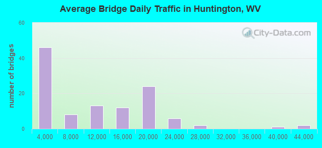
- 1,120,132Total average daily traffic
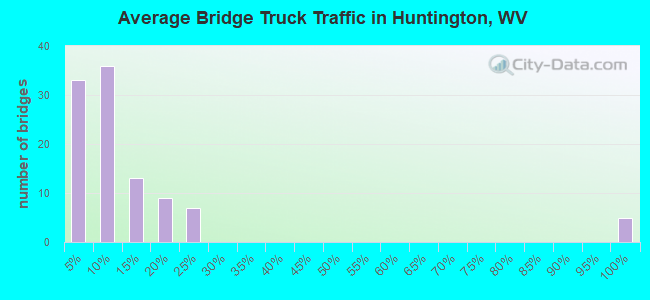
- 208,777Total average daily truck traffic
- National Bridge Inventory (NBI) Registered Bridges for Huntington
- No street view available for this location
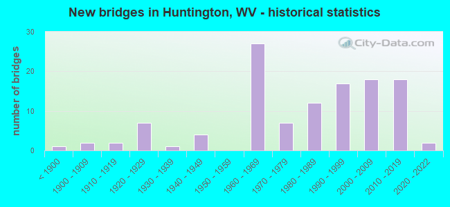
- New bridges - historical statistics
- 1Before 1900
- 21900-1909
- 21910-1919
- 71920-1929
- 11930-1939
- 41940-1949
- 271960-1969
- 71970-1979
- 121980-1989
- 171990-1999
- 182000-2009
- 182010-2019
- 22020-2022
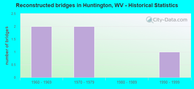
- Reconstructed bridges - Historical Statistics
- 21960-1969
- 21970-1979
- 01980-1989
- 11990-1999
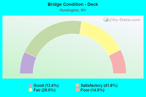
- Bridge Condition - Deck
- 13.4%Good
- 41.8%Satisfactory
- 29.9%Fair
- 14.9%Poor
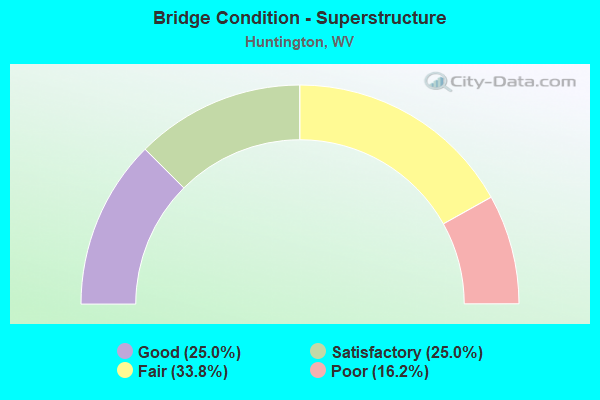
- Bridge Condition - Superstructure
- 25.0%Good
- 25.0%Satisfactory
- 33.8%Fair
- 16.2%Poor
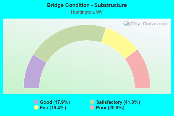
- Bridge Condition - Substructure
- 17.9%Good
- 41.8%Satisfactory
- 19.4%Fair
- 20.9%Poor
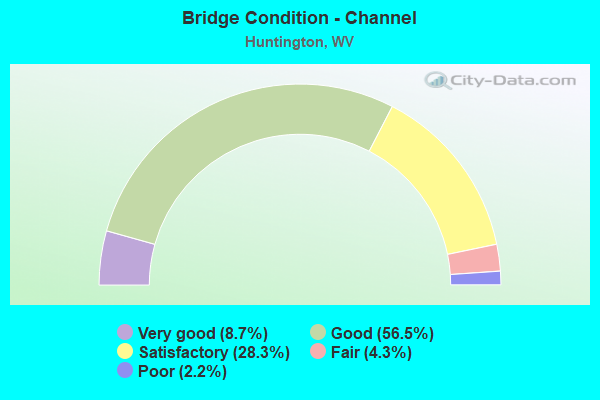
- Bridge Condition - Channel
- 8.7%Very good
- 56.5%Good
- 28.3%Satisfactory
- 4.3%Fair
- 2.2%Poor
Find on map >> Show street view
Structure Number: 6A178, Location: 0.47 MI WEST OF US 52 (Lat: 38.400525, Lng: -82.486981), Route carried "under" structure: City street , Year Built: 1964, Structure Length: 0. m, Average Daily Traffic: 100 (year 0095), Features Intersected: West, East, and Cook Rds, Facility Carried by Structure: I 64 WB
Minimum Vertical Clearance: 25.30m (83.01ft), Kilometerpoint: 0.000, Lanes on structure: 2, Lanes under structure: 1, Length of Maximum Span: 48.8m (160.1ft)
Find on map >> Show street view
Structure Number: 6A178, Location: 0.47 MI WEST OF US 52 (Lat: 38.400558, Lng: -82.486278), Route carried "under" structure: City street , Year Built: 1964, Structure Length: 0. m, Average Daily Traffic: 100 (year 0095), Features Intersected: West, East, and Cook Rds, Facility Carried by Structure: I 64 WB
Minimum Vertical Clearance: 25.30m (83.01ft), Kilometerpoint: 0.000, Lanes on structure: 2, Lanes under structure: 1, Length of Maximum Span: 48.8m (160.1ft)
Find on map >> Show street view
Structure Number: 6A181, Location: 0.72 MI.EAST OF U. S. 52 (Lat: 38.397214, Lng: -82.468142), Route carried "under" structure: County highway 5208, Year Built: 1993, Structure Length: 0. m, Average Daily Traffic: 1,200 (year 0006), Truck Traffic: 4%, Features Intersected: CR 52/8 AND MEDLEY FORK, Facility Carried by Structure: I 64 WB
Minimum Vertical Clearance: 23.24m (76.25ft), Kilometerpoint: 1.658, Lanes on structure: 2, Lanes under structure: 2, Length of Maximum Span: 47.2m (154.9ft)
Find on map >> Show street view
Structure Number: 6A182, Location: 0.30 MI WEST OF CR 37 (Lat: 38.388600, Lng: -82.435569), Route carried "under" structure: County highway 5206, Year Built: 1963, Structure Length: 0. m, Average Daily Traffic: 100 (year 0007), Features Intersected: County Route 52/6, Facility Carried by Structure: I 64 WB
Minimum Vertical Clearance: 13.41m (44.00ft), Kilometerpoint: 0.048, Lanes on structure: 2, Lanes under structure: 2, Length of Maximum Span: 32.2m (105.6ft)
Find on map >> Show street view
Structure Number: 6A21, Location: 0.90 MI NORTH OF I-64 (Lat: 38.412911, Lng: -82.484569), Route carried "under" structure: City street , Year Built: 1968, Structure Length: 0. m, Average Daily Traffic: 100 (year 0007), Features Intersected: VIRGINIA AVENUE, Facility Carried by Structure: US 52
Minimum Vertical Clearance: 4.80m (15.75ft), Kilometerpoint: 0.000, Lanes on structure: 2, Lanes under structure: 2, Length of Maximum Span: 8.8m (28.9ft)
Find on map >> Show street view
Structure Number: 6A213, Location: 0.35 MI SOUTH OF US 60 (Lat: 38.427331, Lng: -82.391350), Route carried "under" structure: Ramp State highway 200, Year Built: 1985, Structure Length: 0. m, Average Daily Traffic: 10,500 (year 0007), Truck Traffic: 4%, Features Intersected: GUYANDOTTE RIVER, WV 2T, Facility Carried by Structure: WV 106 (ON RAMP)
Minimum Vertical Clearance: 8.53m (27.99ft), Kilometerpoint: 0.418, Lanes on structure: 1, Lanes under structure: 2, Length of Maximum Span: 50.6m (166.0ft)
Find on map >> Show street view
Structure Number: 6A214, Location: 0.40 MI NORTH OF US 60 (Lat: 38.428650, Lng: -82.391589), Route carried "under" structure: City street 32000, Year Built: 1985, Structure Length: 0. m, Features Intersected: 3200 Block, Guyandotte R, Facility Carried by Structure: WV 106 (EXIT RAMP)
Minimum Vertical Clearance: 4.14m (13.58ft), Kilometerpoint: 0.000, Lanes on structure: 1, Lanes under structure: 1, Length of Maximum Span: 47.2m (154.9ft)
Find on map >> Show street view
Structure Number: 6A215, Location: 0.67 MI NORTH OF US 60 (Lat: 38.000000, Lng: -82.000000), Route carried "under" structure: State highway 200, Year Built: 1985, Structure Length: 0. m, Average Daily Traffic: 15,500 (year 0001), Truck Traffic: 4%, Features Intersected: OH 7(gov), WV 2, OH Rivr, Facility Carried by Structure: WV 106
Minimum Vertical Clearance: 4.88m (16.01ft), Kilometerpoint: 0.322, Lanes on structure: 2, Lanes under structure: 2, Length of Maximum Span: 274.3m (899.9ft)
Find on map >> Show street view
Structure Number: 6A215, Location: 0.67 MI NORTH OF US 60 (Lat: 38.000000, Lng: -82.000000), Route carried "under" structure: State highway 700, Year Built: 1985, Structure Length: 0. m, Features Intersected: OH 7(gov), WV 2, OH Rivr, Facility Carried by Structure: WV 106
Minimum Vertical Clearance: 4.88m (16.01ft), Kilometerpoint: 0.000, Lanes on structure: 2, Lanes under structure: 2, Length of Maximum Span: 274.3m (899.9ft)
Find on map >> Show street view
Structure Number: 6A222, Location: 0.19 MILE NORTH US 60 EB (Lat: 38.421839, Lng: -82.450400), Route carried "under" structure: US 6000, Year Built: 1994, Structure Length: 0. m, Average Daily Traffic: 12,100 (year 0013), Truck Traffic: 4%, Features Intersected: OHIO RIVER;CSX;US 60 WB, Facility Carried by Structure: WV 527
Minimum Vertical Clearance: 4.93m (16.17ft), Kilometerpoint: 0.531, Lanes on structure: 4, Lanes under structure: 4, Length of Maximum Span: 219.5m (720.1ft)
Find on map >> Show street view
Structure Number: 6A268, Location: 0.36 MILE EAST OF WV 10 (Lat: 38.425131, Lng: -82.425769), Route carried "under" structure: US 6000, Year Built: 2003, Structure Length: 0. m, Average Daily Traffic: 12,806 (year 2019), Truck Traffic: 6%, Features Intersected: U.S.60 WESTBOUND, Facility Carried by Structure: PEDESTRIAN BRIDGE
Minimum Vertical Clearance: 5.46m (17.91ft), Kilometerpoint: 3.106, Lanes under structure: 4, Material/Design: Steel continuous, Design/Construction: Girder and Floorbeam System, Length of Maximum Span: 22.5m (73.8ft)
Find on map >> Show street view
Structure Number: 6A273, Location: 0.26 MILE EAT OF WV 10 (Lat: 38.424781, Lng: -82.428031), Route carried "under" structure: US 6000, Year Built: 2005, Structure Length: 0. m, Average Daily Traffic: 12,806 (year 2019), Truck Traffic: 6%, Features Intersected: US 60 WESTBOUND, Facility Carried by Structure: PEDESTRIAN BRIDGE
Minimum Vertical Clearance: 6.12m (20.08ft), Kilometerpoint: 3.267, Lanes under structure: 4, Material/Design: Steel continuous, Design/Construction: Girder and Floorbeam System, Length of Maximum Span: 22.5m (73.8ft)
Find on map >> Show street view
Structure Number: 6A277, Location: 0.38 MILE WEST OF US 60 (Lat: 38.409331, Lng: -82.353061), Route carried "under" structure: County highway 6002, Year Built: 2006, Structure Length: 0. m, Average Daily Traffic: 1,200 (year 0007), Truck Traffic: 4%, Features Intersected: County Route 60/2, Facility Carried by Structure: INTERSTATE 64
Minimum Vertical Clearance: 4.42m (14.50ft), Kilometerpoint: 0.435, Lanes on structure: 3, Lanes under structure: 2, Length of Maximum Span: 17.7m (58.1ft)
Find on map >> Show street view
Structure Number: 6A278, Location: 0.38 MILES WEST OF US 60 (Lat: 38.409500, Lng: -82.353269), Route carried "under" structure: County highway 6002, Year Built: 2006, Structure Length: 0. m, Average Daily Traffic: 1,200 (year 0007), Truck Traffic: 4%, Features Intersected: CO RT 60/2 DARNELL RD, Facility Carried by Structure: INTERSTATE 64 WBL
Minimum Vertical Clearance: 4.42m (14.50ft), Kilometerpoint: 0.435, Lanes on structure: 3, Lanes under structure: 2, Length of Maximum Span: 17.7m (58.1ft)
Find on map >> Show street view
Structure Number: 6A285, Location: 0.17.MILES WEST OF US 52 (Lat: 38.401089, Lng: -82.482911), Route carried "under" structure: City street , Year Built: 2007, Structure Length: 0. m, Features Intersected: 19TH STREET, Facility Carried by Structure: INTERSTATE 64 EB
Minimum Vertical Clearance: 13.28m (43.57ft), Kilometerpoint: 0.418, Lanes on structure: 2, Lanes under structure: 2, Length of Maximum Span: 31.6m (103.7ft)
Find on map >> Show street view
Structure Number: 6A286, Location: 0.17 MILE WEST OF U S 52 (Lat: 38.401269, Lng: -82.482950), Route carried "under" structure: City street , Year Built: 2007, Structure Length: 0. m, Features Intersected: 19TH STREET, Facility Carried by Structure: INTERSTATE 64 WB
Minimum Vertical Clearance: 13.28m (43.57ft), Kilometerpoint: 0.418, Lanes on structure: 2, Lanes under structure: 2, Length of Maximum Span: 31.6m (103.7ft)
Find on map >> Show street view
Structure Number: 6A294, Location: 2.74 miles east of WV 152 (Lat: 38.393364, Lng: -82.405400), Route carried "under" structure: State highway 1000, Year Built: 2010, Structure Length: 0. m, Average Daily Traffic: 16,000 (year 2010), Truck Traffic: 99%, Features Intersected: WV 10; FOUR POLE CREEK, Facility Carried by Structure: I64 EB
Minimum Vertical Clearance: 5.00m (16.40ft), Kilometerpoint: 25.267, Lanes on structure: 2, Lanes under structure: 2, Length of Maximum Span: 38.9m (127.6ft)
Find on map >> Show street view
Structure Number: 6A294, Location: 2.74 miles east of WV 152 (Lat: 38.393364, Lng: -82.405400), Route carried "under" structure: State highway 1000, Year Built: 2010, Structure Length: 0. m, Average Daily Traffic: 16,000 (year 2010), Truck Traffic: 99%, Features Intersected: WV 10; FOUR POLE CREEK, Facility Carried by Structure: I64 EB
Minimum Vertical Clearance: 4.93m (16.17ft), Kilometerpoint: 25.267, Lanes on structure: 2, Lanes under structure: 2, Length of Maximum Span: 38.9m (127.6ft)
Find on map >> Show street view
Structure Number: 6A296, Location: 2.74 miles east of WV 152 (Lat: 38.393364, Lng: -82.405400), Route carried "under" structure: State highway 1000, Year Built: 2010, Structure Length: 0. m, Average Daily Traffic: 16,000 (year 2010), Truck Traffic: 99%, Features Intersected: WV 10; FOUR POLE CREEK, Facility Carried by Structure: I64 WB
Minimum Vertical Clearance: 5.00m (16.40ft), Kilometerpoint: 25.267, Lanes on structure: 2, Lanes under structure: 2, Length of Maximum Span: 44.2m (145.0ft)
Find on map >> Show street view
Structure Number: 6A296, Location: 2.74 miles east of WV 152 (Lat: 38.393364, Lng: -82.405400), Route carried "under" structure: State highway 1000, Year Built: 2010, Structure Length: 0. m, Average Daily Traffic: 16,000 (year 2010), Truck Traffic: 99%, Features Intersected: WV 10; FOUR POLE CREEK, Facility Carried by Structure: I64 WB
Minimum Vertical Clearance: 4.93m (16.17ft), Kilometerpoint: 25.267, Lanes on structure: 2, Lanes under structure: 2, Length of Maximum Span: 44.2m (145.0ft)
Find on map >> Show street view
Structure Number: 6A301, Location: 0.78 MI WEST OF CR 60/2 (Lat: 38.405850, Lng: -82.365650), Route carried "under" structure: County highway 440, Year Built: 2014, Structure Length: 0. m, Average Daily Traffic: 38,815 (year 2013), Truck Traffic: 99%, Features Intersected: CEDAR CREST DRIVE, Facility Carried by Structure: Interstate 64
Minimum Vertical Clearance: 5.33m (17.49ft), Kilometerpoint: 2.414, Lanes on structure: 6, Lanes under structure: 2, Length of Maximum Span: 34.4m (112.9ft)
Find on map >> Show street view
Structure Number: 6A311, Location: 1.73 MI WEST OF WV 152 (Lat: 38.401550, Lng: -82.480083), Route carried "under" structure: Alternate US 5200, Year Built: 2017, Structure Length: 0. m, Average Daily Traffic: 9,000 (year 0006), Truck Traffic: 4%, Features Intersected: US 52, Facility Carried by Structure: I 64 EB
Minimum Vertical Clearance: 5.16m (16.93ft), Kilometerpoint: 2.092, Lanes on structure: 3, Lanes under structure: 2, Length of Maximum Span: 19.8m (65.0ft)
Find on map >> Show street view
Structure Number: 6A312, Location: 1.73 MI WEST OF WV 152 (Lat: 38.401769, Lng: -82.480081), Route carried "under" structure: Alternate US 5200, Year Built: 2017, Structure Length: 0. m, Average Daily Traffic: 9,000 (year 0006), Truck Traffic: 4%, Features Intersected: US 52, Facility Carried by Structure: I 64 WB
Minimum Vertical Clearance: 5.16m (16.93ft), Kilometerpoint: 2.092, Lanes on structure: 2, Lanes under structure: 2, Length of Maximum Span: 19.8m (65.0ft)
Find on map >> Show street view
Structure Number: 6A315, Location: 0.16 MI SOUTH OF WV 527 (Lat: 38.394031, Lng: -82.452369), Route carried "under" structure: Interstate 640, Year Built: 2018, Structure Length: 0. m, Average Daily Traffic: 43,000 (year 2016), Truck Traffic: 21%, Features Intersected: INTERSTATE 64, Facility Carried by Structure: WV ROUTE 152
Minimum Vertical Clearance: 5.11m (16.77ft), Kilometerpoint: 13.148, Lanes on structure: 5, Lanes under structure: 5, Length of Maximum Span: 33.2m (108.9ft)
Find on map >> Show street view
Structure Number: 6A904, Location: 0.04 MI NORTH OF MEM. BLV (Lat: 38.405739, Lng: -82.477100), Route carried "under" structure: City street N0760, Year Built: 1929, Structure Length: 0. m, Average Daily Traffic: 7,500 (year 2019), Truck Traffic: 4%, Features Intersected: 14th street west, Facility Carried by Structure: CSX RAILROAD
Minimum Vertical Clearance: 3.91m (12.83ft), Kilometerpoint: 0.097, Lanes under structure: 2, Length of Maximum Span: 10.3m (33.8ft)
Find on map >> Show street view
Structure Number: 6A909, Location: 0.05 MI SOUTH OF 7TH AVE (Lat: 38.413389, Lng: -82.456081), Route carried "under" structure: City street N0760, Year Built: 1936, Structure Length: 0. m, Average Daily Traffic: 9,026 (year 2019), Truck Traffic: 7%, Features Intersected: First Street east, Facility Carried by Structure: CSX RAILROAD
Minimum Vertical Clearance: 4.34m (14.24ft), Kilometerpoint: 0.209, Lanes under structure: 4, Length of Maximum Span: 13.1m (43.0ft)
Find on map >> Show street view
Structure Number: 6A91, Location: 0.05 MI SOUTH OF 7TH AVE (Lat: 38.419411, Lng: -82.421531), Route carried "under" structure: City street N0760, Year Built: 1905, Structure Length: 0. m, Average Daily Traffic: 21,200 (year 2019), Truck Traffic: 4%, Features Intersected: 20TH STREET EAST, Facility Carried by Structure: CSX RAILROAD
Minimum Vertical Clearance: 3.53m (11.58ft), Kilometerpoint: 0.225, Lanes under structure: 5, Length of Maximum Span: 14.0m (45.9ft)
Find on map >> Show street view
Structure Number: 6A914, Location: 0.04 MI SOUTH OF 7TH AVE (Lat: 38.416100, Lng: -82.440600), Route carried "under" structure: City street N0760, Year Built: 1917, Structure Length: 0. m, Average Daily Traffic: 10,500 (year 2017), Truck Traffic: 4%, Features Intersected: 10TH STREET, Facility Carried by Structure: CSX RAILROAD
Minimum Vertical Clearance: 3.71m (12.17ft), Kilometerpoint: 0.290, Lanes under structure: 2, Material/Design: Steel continuous, Design/Construction: Girder and Floorbeam System, Length of Maximum Span: 9.1m (29.9ft)
Find on map >> Show street view
Structure Number: 50A143, Location: 2.03 MILE WEST OF US 52 (Lat: 38.395531, Lng: -82.515811), Route carried "under" structure: County highway 700, Year Built: 1993, Structure Length: 0. m, Average Daily Traffic: 10,500 (year 0007), Truck Traffic: 11%, Features Intersected: COUNTY ROUTE 7, Facility Carried by Structure: I 64 EB
Minimum Vertical Clearance: 13.72m (45.01ft), Kilometerpoint: 32.203, Lanes on structure: 2, Lanes under structure: 2, Length of Maximum Span: 61.0m (200.1ft)
Find on map >> Show street view
Structure Number: 50A16, Location: 2.03 MILE WEST OF US 52 (Lat: 38.395711, Lng: -82.515850), Route carried "under" structure: County highway 700, Year Built: 1993, Structure Length: 0. m, Average Daily Traffic: 10,500 (year 0007), Truck Traffic: 11%, Features Intersected: COUNTY ROUTE 7, Facility Carried by Structure: I 64 WBL
Minimum Vertical Clearance: 13.72m (45.01ft), Kilometerpoint: 32.203, Lanes on structure: 2, Lanes under structure: 2, Length of Maximum Span: 61.0m (200.1ft)
Find on map >> Show street view
Structure Number: 50A18, Location: 0.23 MILE SOUTH OF US 60 (Lat: 38.396444, Lng: -82.516406), Route carried "under" structure: County highway 6003, Year Built: 1998, Structure Length: 0. m, Average Daily Traffic: 1,500 (year 0007), Truck Traffic: 11%, Features Intersected: CR 60/3 & CSX RR, Facility Carried by Structure: CR 7
Minimum Vertical Clearance: 7.39m (24.25ft), Kilometerpoint: 0.097, Lanes on structure: 2, Lanes under structure: 2, Length of Maximum Span: 20.7m (67.9ft)
Find on map >> Show street view
Structure Number: 50A21, Location: 1.17 MILE WEST OF US 52 (Lat: 38.397469, Lng: -82.500231), Route carried "under" structure: County highway 6002, Year Built: 2005, Structure Length: 0. m, Average Daily Traffic: 50 (year 0007), Features Intersected: EDGEWOOD DRIVE, Facility Carried by Structure: INTERSTATE 64
Minimum Vertical Clearance: 21.34m (70.01ft), Kilometerpoint: 0.064, Lanes on structure: 2, Lanes under structure: 1, Length of Maximum Span: 42.7m (140.1ft)
Find on map >> Show street view
Structure Number: 50A211, Location: 1.17 MILE WEST OF US 52 (Lat: 38.397650, Lng: -82.500319), Route carried "under" structure: County highway 6002, Year Built: 2005, Structure Length: 0. m, Average Daily Traffic: 50 (year 0007), Features Intersected: EDGEWOOD DRIVE, Facility Carried by Structure: INTERSTATE 64
Minimum Vertical Clearance: 21.34m (70.01ft), Kilometerpoint: 0.064, Lanes on structure: 2, Lanes under structure: 2, Length of Maximum Span: 42.7m (140.1ft)