Bridge Statistics for Huntington Beach, California (CA)
Condition, Traffic, Stress, Structural Evaluation, Project Costs
- National Bridge Inventory (NBI) Statistics
- 51Number of bridges
- 600ft / 183mTotal length
- $3,847,000Total costs
- 2,440,595Total average daily traffic
- 103,165Total average daily truck traffic
- National Bridge Inventory (NBI) Registered Bridges for Huntington Beach
- No street view available for this location
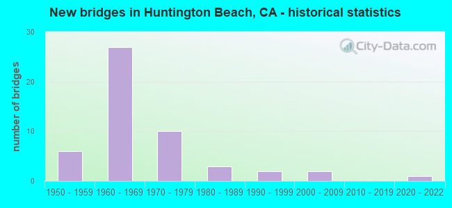
- New bridges - historical statistics
- 61950-1959
- 271960-1969
- 101970-1979
- 31980-1989
- 21990-1999
- 22000-2009
- 12020-2022

- Reconstructed bridges - Historical Statistics
- 51960-1969
- 21970-1979
- 31980-1989
- 21990-1999


- Bridge Condition - Deck
- 75.0%Good
- 3.6%Satisfactory
- 17.9%Fair
- 3.6%Poor

- Bridge Condition - Superstructure
- 78.6%Good
- 14.3%Fair
- 7.1%Poor

- Bridge Condition - Substructure
- 78.6%Good
- 17.9%Fair
- 3.6%Poor

- Bridge Condition - Channel
- 25.0%Excellent
- 70.0%Very good
- 5.0%Good

- Bridge Condition - Culverts
- 68.8%Good
- 31.3%Satisfactory
Find on map >> Show street view
Structure Number: 55C0454, Location: 50' N/O EDINGER AVENUE (Lat: 33.730056, Lng: -118.025444), Route carried "on" structure: City street , Year Built: 1963, Status: Open, Structure Length: 2.56m (8.40ft), Average Daily Traffic: 4,900 (year 2015), Truck Traffic: 1%, Average Future Daily Traffic: 3,165 (year 2038), Features Intersected: WESTMINSTER CHANNEL, Facility Carried by Structure: MARINA HIGH ACC RD
Minimum Vertical Clearance: 30+ m (98+ ft), Kilometerpoint: 0.000, Lanes on structure: 2, Owner: City or Municipal Highway Agency, Approaching Roadway Width: 7.2m (23.6ft), Material/Design: Prestressed concrete, Design/Construction: Slab, Number Of Spans In Main Unit: 3, Length of Maximum Span: 8.2m (26.9ft), Curb-To-Curb Width: 7.2m (23.6ft), Out-to-Out Width: 8.2m (26.9ft)
Condition: Deck: Good, Superstructure: Good, Substructure: Good, Channel: Good, Operating Rating: 37.3 metric tons, Method Used To Determine Operating Rating: Field evaluation and documented engineering judgment, Inventory Rating: 22.4 metric tons, Method Used To Determine Inventory Rating: Field evaluation and documented engineering judgment, Structural Evaluation: Somewhat better than minimum adequacy, Deck Geometry: High priority of replacement, Waterway Adequacy: Equal to present desirable criteria, Approach Roadway Alignment: Equal to present desirable criteria, Designated Inspection Frequency: Every 24 months, Inspection Date: June 2021, Deck Structure Type: Concrete Precast Panels, Wearing Surface/Protective System: Wearing Surface: Bituminous
Find on map >> Show street view
Structure Number: 55C0455, Location: 50' W/O SPRINGDALE STREET (Lat: 33.732217, Lng: -118.024500), Route carried "on" structure: City street , Year Built: 1963, Status: Open, Structure Length: 2.23m (7.32ft), Average Daily Traffic: 3,000 (year 2015), Truck Traffic: 1%, Average Future Daily Traffic: 1,582 (year 2038), Features Intersected: WESTMINSTER CHANNEL, Facility Carried by Structure: MARINA VIKING WAY
Minimum Vertical Clearance: 30+ m (98+ ft), Kilometerpoint: 0.000, Lanes on structure: 3, Base Highway Network: Yes, Owner: City or Municipal Highway Agency, Approaching Roadway Width: 14.7m (48.2ft), Material/Design: Prestressed concrete, Design/Construction: Slab, Number Of Spans In Main Unit: 3, Length of Maximum Span: 7.3m (24.0ft), Curb or Sidewalk Widths: Left: 0.0m, Right: 2.1m (6.9ft), Curb-To-Curb Width: 14.7m (48.2ft), Out-to-Out Width: 17.5m (57.4ft)
Condition: Deck: Good, Superstructure: Good, Substructure: Good, Channel: Very good, Operating Rating: 40.5 metric tons, Method Used To Determine Operating Rating: Field evaluation and documented engineering judgment, Inventory Rating: 24.3 metric tons, Method Used To Determine Inventory Rating: Field evaluation and documented engineering judgment, Structural Evaluation: Equal to present minimum criteria, Deck Geometry: Somewhat better than minimum adequacy, Waterway Adequacy: Superior to present desirable criteria, Approach Roadway Alignment: Equal to present desirable criteria, Designated Inspection Frequency: Every 24 months, Inspection Date: June 2021, Deck Structure Type: Concrete Precast Panels, Wearing Surface/Protective System: Wearing Surface: Bituminous
Find on map >> Show street view
Structure Number: 55C0456, Location: AT SPRINGDALE ST (Lat: 33.737028, Lng: -118.024514), Route carried "on" structure: City street , Year Built: 1963, Status: Open, Structure Length: 1.55m (5.09ft), Average Daily Traffic: 22,000 (year 2020), Truck Traffic: 1%, Average Future Daily Traffic: 16,876 (year 2040), Design Load: HS 20, Features Intersected: WESTMINSTER CHANNEL, Facility Carried by Structure: MCFADDEN AVE
Minimum Vertical Clearance: 30+ m (98+ ft), Kilometerpoint: 0.000, Lanes on structure: 6, Owner: City or Municipal Highway Agency, Approaching Roadway Width: 19.5m (64.0ft), Skew: 9 degrees, Material/Design: Concrete, Design/Construction: Culvert, Number Of Spans In Main Unit: 3, Length of Maximum Span: 4.5m (14.8ft), Curb or Sidewalk Widths: Left: 2.7m (8.9ft), Right: 2.5m (8.2ft)
Condition: Channel: Very good, Culverts: Good, Operating Rating: 54.1 metric tons, Method Used To Determine Operating Rating: Field evaluation and documented engineering judgment, Inventory Rating: 32.4 metric tons, Method Used To Determine Inventory Rating: Field evaluation and documented engineering judgment, Structural Evaluation: Better than present minimum criteria, Waterway Adequacy: Superior to present desirable criteria, Approach Roadway Alignment: Equal to present desirable criteria, Designated Inspection Frequency: Every 48 months, Inspection Date: April 2020
Find on map >> Show street view
Structure Number: 55C0583, Location: 0.2 MI E/O GOLDEN WEST (Lat: 33.722753, Lng: -118.002353), Route carried "on" structure: City street , Year Built: 1987, Status: Open, Structure Length: 0.91m (2.99ft), Average Daily Traffic: 13,000 (year 2015), Truck Traffic: 1%, Average Future Daily Traffic: 16,988 (year 2036), Features Intersected: HUNTINGTON CENTER STORM, Facility Carried by Structure: HEIL AVE
Minimum Vertical Clearance: 30+ m (98+ ft), Kilometerpoint: 0.000, Lanes on structure: 5, Owner: City or Municipal Highway Agency, Approaching Roadway Width: 19.4m (63.6ft), Material/Design: Concrete, Design/Construction: Culvert, Number Of Spans In Main Unit: 2, Length of Maximum Span: 4.5m (14.8ft), Curb or Sidewalk Widths: Left: 1.5m (4.9ft), Right: 2.2m (7.2ft), Curb-To-Curb Width: 19.4m (63.6ft), Out-to-Out Width: 24.4m (80.1ft)
Condition: Channel: Excellent, Culverts: Good, Operating Rating: 54.1 metric tons, Method Used To Determine Operating Rating: Field evaluation and documented engineering judgment, Inventory Rating: 32.4 metric tons, Method Used To Determine Inventory Rating: Field evaluation and documented engineering judgment, Structural Evaluation: Better than present minimum criteria, Deck Geometry: Meets minimum limits, Waterway Adequacy: Superior to present desirable criteria, Approach Roadway Alignment: Equal to present desirable criteria, Designated Inspection Frequency: Every 48 months, Inspection Date: May 2018, Deck Structure Type: Concrete Cast-file-Place, Wearing Surface/Protective System: Wearing Surface: Bituminous
Find on map >> Show street view
Structure Number: 55 0265, Location: 12-ORA-405-15.90-HNTB (Lat: 33.726303, Lng: -117.980675), Route carried "under" structure: Interstate 405, Year Built: 1966, Structure Length: 0. m, Average Daily Traffic: 263,000 (year 2011), Truck Traffic: 7%, Features Intersected: ROUTE 405, Facility Carried by Structure: NEWLAND ST
Minimum Vertical Clearance: 5.28m (17.32ft), Kilometerpoint: 15.900, Lanes on structure: 2, Lanes under structure: 10, Material/Design: Concrete continuous, Design/Construction: Box Beam or Girders - Multiple, Length of Maximum Span: 32.0m (105.0ft)
Find on map >> Show street view
Structure Number: 55 0267, Location: 12-ORA-405-16.52-HNTB (Lat: 33.732861, Lng: -117.989008), Route carried "under" structure: State highway 39, Year Built: 1965, Structure Length: 0. m, Average Daily Traffic: 77,000 (year 2013), Truck Traffic: 1%, Features Intersected: ROUTE 39, Facility Carried by Structure: INTERSTATE 405
Minimum Vertical Clearance: 4.64m (15.22ft), Kilometerpoint: 5.800, Lanes on structure: 14, Lanes under structure: 8, Material/Design: Concrete continuous, Design/Construction: Box Beam or Girders - Multiple, Length of Maximum Span: 28.7m (94.2ft)
Find on map >> Show street view
Structure Number: 55 0407, Location: 12-ORA-405-15.48-HNTB (Lat: 33.722897, Lng: -117.975961), Route carried "under" structure: Interstate 405, Year Built: 1966, Structure Length: 0. m, Average Daily Traffic: 263,000 (year 2009), Truck Traffic: 7%, Features Intersected: INTERSTATE 405, Facility Carried by Structure: PEDESTRIAN WALKWAY
Minimum Vertical Clearance: 5.89m (19.32ft), Kilometerpoint: 15.480, Lanes under structure: 10, Material/Design: Concrete continuous, Design/Construction: Box Beam or Girders - Multiple, Length of Maximum Span: 26.2m (86.0ft)
Find on map >> Show street view
Structure Number: 55 0407, Location: 12-ORA-405-15.48-HNTB (Lat: 33.722897, Lng: -117.975961), Route carried "under" structure: Ramp Interstate 405, Year Built: 1966, Structure Length: 0. m, Average Daily Traffic: 2,650 (year 2009), Truck Traffic: 4%, Features Intersected: INTERSTATE 405, Facility Carried by Structure: PEDESTRIAN WALKWAY
Minimum Vertical Clearance: 5.92m (19.42ft), Kilometerpoint: 15.480, Lanes under structure: 1, Material/Design: Concrete continuous, Design/Construction: Box Beam or Girders - Multiple, Length of Maximum Span: 26.2m (86.0ft)
Find on map >> Show street view
Structure Number: 55 1045, Location: 12-ORA-001-24.10-HNTB (Lat: 33.650675, Lng: -117.991869), Route carried "under" structure: State highway 1, Year Built: 2008, Structure Length: 0. m, Average Daily Traffic: 37,000 (year 2009), Truck Traffic: 1%, Features Intersected: STATE ROUTE 1, Facility Carried by Structure: PEDESTRIAN WALKWAY
Minimum Vertical Clearance: 5.71m (18.73ft), Kilometerpoint: 24.100, Lanes under structure: 5, Material/Design: Prestressed concrete, Design/Construction: Stringer/Multi-beam, Length of Maximum Span: 37.7m (123.7ft)
Find on map >> Show street view
Structure Number: 55 1121, Location: 12-ORA-405-15.21-HNTB (Lat: 33.719250, Lng: -117.971722), Route carried "under" structure: Interstate 405, Year Built: 2021, Structure Length: 0. m, Average Daily Traffic: 263,000 (year 2021), Truck Traffic: 7%, Features Intersected: ROUTE 405, Facility Carried by Structure: MAGNOLIA STREET
Minimum Vertical Clearance: 5.79m (19.00ft), Kilometerpoint: 15.210, Lanes on structure: 6, Lanes under structure: 11, Material/Design: Concrete continuous, Design/Construction: Box Beam or Girders - Multiple, Length of Maximum Span: 71.8m (235.6ft)
Find on map >> Show street view
Structure Number: 55C0448, Location: 0.5 MI W ROUTE 39 (Lat: 33.693400, Lng: -117.997589), Route carried "under" structure: City street , Year Built: 1980, Structure Length: 0. m, Average Daily Traffic: 10,000 (year 2018), Truck Traffic: 2%, Features Intersected: ELLIS AVENUE, Facility Carried by Structure: UP RR
Minimum Vertical Clearance: 4.60m (15.09ft), Kilometerpoint: 0.000, Lanes under structure: 2, Material/Design: Concrete, Design/Construction: Box Beam or Girders - Multiple, Length of Maximum Span: 20.1m (65.9ft)