Bridge Statistics for Hornellsville, New York (NY)
Condition, Traffic, Stress, Structural Evaluation, Project Costs
- National Bridge Inventory (NBI) Statistics
- 46Number of bridges
- 502ft / 153mTotal length
- $100,023,000Total costs
- 109,960Total average daily traffic
- 12,390Total average daily truck traffic
- National Bridge Inventory (NBI) Registered Bridges for Hornellsville
- No street view available for this location
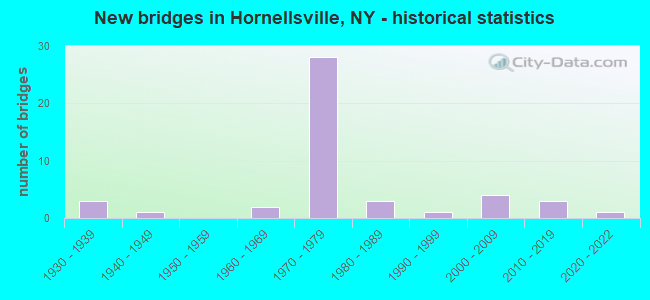
- New bridges - historical statistics
- 31930-1939
- 11940-1949
- 21960-1969
- 281970-1979
- 31980-1989
- 11990-1999
- 42000-2009
- 32010-2019
- 12020-2022

- Reconstructed bridges - Historical Statistics
- 21980-1989
- 21990-1999
- 32000-2009
- 22010-2019


- Bridge Condition - Deck
- 16.7%Excellent
- 16.7%Very good
- 26.7%Good
- 20.0%Satisfactory
- 20.0%Fair

- Bridge Condition - Superstructure
- 26.7%Excellent
- 13.3%Very good
- 26.7%Good
- 30.0%Satisfactory
- 3.3%Fair

- Bridge Condition - Substructure
- 26.7%Excellent
- 6.7%Very good
- 6.7%Good
- 30.0%Satisfactory
- 26.7%Fair
- 3.3%Poor

- Bridge Condition - Channel
- 3.1%Excellent
- 6.3%Very good
- 31.3%Good
- 37.5%Satisfactory
- 12.5%Fair
- 9.4%Poor

- Bridge Condition - Culverts
- 33.3%Good
- 44.4%Satisfactory
- 11.1%Fair
- 11.1%Poor
Find on map >> Show street view
Structure Number: 335881, Location: 2.3 MI SW OF HORNELL (Lat: 42.299447, Lng: -77.712603), Route carried "on" structure: County highway , Year Built: 1972, Status: Open, Structure Length: 1.01m (3.31ft), Average Daily Traffic: 446 (year 2018), Truck Traffic: 3%, Average Future Daily Traffic: 465 (year 2040), Features Intersected: CROSBY CREEK, Facility Carried by Structure: COUNTY ROAD 68
Minimum Vertical Clearance: 30+ m (98+ ft), Kilometerpoint: 4.553, Lanes on structure: 2, Owner: County Highway Agency, Approaching Roadway Width: 6.4m (21.0ft), Skew: 2 degrees, Material/Design: Steel, Design/Construction: Culvert, Number Of Spans In Main Unit: 2, Length of Maximum Span: 3.9m (12.8ft)
Condition: Channel: Poor, Culverts: Fair, Operating Rating: 89.8 metric tons, Method Used To Determine Operating Rating: Load Factor (LF), Inventory Rating: 78.0 metric tons, Method Used To Determine Inventory Rating: Load Factor (LF), Structural Evaluation: Somewhat better than minimum adequacy, Waterway Adequacy: Meets minimum limits, Approach Roadway Alignment: Meets minimum limits, Length Of Structure Improvement: 1.00m (3.28ft), Designated Inspection Frequency: Every 24 months, Inspection Date: November 2021, Bridge Improvement Cost: $140,000, Roadway Improvement Cost: $82,000, Total Project Cost: $221,000 ( Estimate for 2021)
Find on map >> Show street view
Structure Number: 1028621, Location: JCT RTS 17 + 36 (Lat: 42.370264, Lng: -77.677292), Route carried "under" structure: Interstate 36, Year Built: 1970, Structure Length: 0. m, Average Daily Traffic: 1,626 (year 1999), Features Intersected: 36 36 64021046 (NB), RTE, Facility Carried by Structure: RTE I86
Minimum Vertical Clearance: 4.65m (15.26ft), Kilometerpoint: 7.466, Lanes on structure: 3, Lanes under structure: 3, Material/Design: Steel continuous, Design/Construction: Stringer/Multi-beam, Length of Maximum Span: 28.3m (92.8ft)
Find on map >> Show street view
Structure Number: 1028622, Location: JCT RTS 17 + 36 (Lat: 42.370164, Lng: -77.676814), Route carried "under" structure: State highway 36, Year Built: 1970, Structure Length: 0. m, Average Daily Traffic: 1,626 (year 1999), Features Intersected: 36 36 64021046 (NB), RTE, Facility Carried by Structure: RTE I86
Minimum Vertical Clearance: 4.70m (15.42ft), Kilometerpoint: 7.466, Lanes on structure: 3, Lanes under structure: 3, Material/Design: Steel continuous, Design/Construction: Stringer/Multi-beam, Length of Maximum Span: 28.9m (94.8ft)
Find on map >> Show street view
Structure Number: 1061651, Location: .5 MILE W JCT I86 & SR 36 (Lat: 42.367739, Lng: -77.683044), Route carried "under" structure: County highway , Year Built: 1973, Structure Length: 0. m, Average Daily Traffic: 402 (year 2018), Truck Traffic: 8%, Features Intersected: NORFOLK SOUTHERN RR, COU, Facility Carried by Structure: RTE I86
Minimum Vertical Clearance: 5.79m (19.00ft), Kilometerpoint: 3.041, Lanes on structure: 3, Lanes under structure: 2, Material/Design: Steel, Design/Construction: Stringer/Multi-beam, Length of Maximum Span: 32.6m (107.0ft)
Find on map >> Show street view
Structure Number: 1061652, Location: .5 MILE W JCT I86 & SR 36 (Lat: 42.367339, Lng: -77.682786), Route carried "under" structure: County highway , Year Built: 1973, Structure Length: 0. m, Average Daily Traffic: 402 (year 2018), Truck Traffic: 8%, Features Intersected: NORFOLK SOUTHERN RR, COU, Facility Carried by Structure: RTE I86
Minimum Vertical Clearance: 6.38m (20.93ft), Kilometerpoint: 1.464, Lanes on structure: 2, Lanes under structure: 2, Material/Design: Steel, Design/Construction: Stringer/Multi-beam, Length of Maximum Span: 32.0m (105.0ft)
Find on map >> Show street view
Structure Number: 1061911, Location: .4 MILE E JCT I86 & SR 36 (Lat: 42.375714, Lng: -77.671189), Route carried "under" structure: ServiceOther road , Year Built: 1970, Structure Length: 0. m, Average Daily Traffic: 200 (year 0000), Features Intersected: AIRPORT ROAD, Facility Carried by Structure: RTE I86
Minimum Vertical Clearance: 5.79m (19.00ft), Kilometerpoint: 1.641, Lanes on structure: 2, Lanes under structure: 2, Material/Design: Steel, Design/Construction: Stringer/Multi-beam, Length of Maximum Span: 31.7m (104.0ft)
Find on map >> Show street view
Structure Number: 1061912, Location: .4 MILE E JCT I86 & SR 36 (Lat: 42.375228, Lng: -77.670964), Route carried "under" structure: ServiceOther road , Year Built: 1970, Structure Length: 0. m, Average Daily Traffic: 200 (year 2021), Features Intersected: AIRPORT ROAD, Facility Carried by Structure: RTE I86
Minimum Vertical Clearance: 8.53m (27.99ft), Kilometerpoint: 1.641, Lanes on structure: 3, Lanes under structure: 2, Material/Design: Steel, Design/Construction: Stringer/Multi-beam, Length of Maximum Span: 43.2m (141.7ft)
Find on map >> Show street view
Structure Number: 106219, Location: 1.2 MI SW JCT RTS 17 + 36 (Lat: 42.363350, Lng: -77.699994), Route carried "under" structure: Interstate 86, Year Built: 1973, Structure Length: 0. m, Average Daily Traffic: 2,900 (year 1975), Features Intersected: 86I 17 64044028 (WB), R, Facility Carried by Structure: DOORLEY ROAD
Minimum Vertical Clearance: 4.98m (16.34ft), Kilometerpoint: 4.521, Lanes on structure: 2, Lanes under structure: 2, Material/Design: Steel, Design/Construction: Stringer/Multi-beam, Length of Maximum Span: 39.6m (129.9ft)