Bridge Statistics for Heflin, Alabama (AL)
Condition, Traffic, Stress, Structural Evaluation, Project Costs
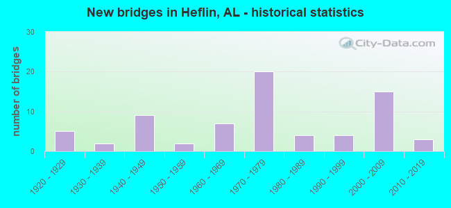
- New bridges - historical statistics
- 51920-1929
- 21930-1939
- 91940-1949
- 21950-1959
- 71960-1969
- 201970-1979
- 41980-1989
- 41990-1999
- 152000-2009
- 32010-2019

- Reconstructed bridges - Historical Statistics
- 11940-1949
- 01950-1959
- 01960-1969
- 01970-1979
- 11980-1989
- 11990-1999


- Bridge Condition - Deck
- 5.0%Excellent
- 12.5%Very good
- 20.0%Good
- 20.0%Satisfactory
- 32.5%Fair
- 7.5%Poor
- 2.5%Serious

- Bridge Condition - Superstructure
- 2.5%Excellent
- 10.0%Very good
- 30.0%Good
- 20.0%Satisfactory
- 30.0%Fair
- 2.5%Poor
- 2.5%Serious
- 2.5%Critical

- Bridge Condition - Substructure
- 2.5%Excellent
- 7.5%Very good
- 47.5%Good
- 10.0%Satisfactory
- 27.5%Fair
- 5.0%Poor

- Bridge Condition - Channel
- 1.8%Excellent
- 22.8%Very good
- 17.5%Good
- 29.8%Satisfactory
- 24.6%Fair
- 3.5%Poor

- Bridge Condition - Culverts
- 16.7%Excellent
- 16.7%Very good
- 16.7%Good
- 25.0%Satisfactory
- 25.0%Fair
Find on map >> Show street view
Structure Number: 179, Location: 1.7 M E OF CO 532 (Lat: 33.008761, Lng: -85.631169), Route carried "on" structure: County highway 569, Year Built: 1921, Status: Posted for load, Structure Length: 1.07m (3.51ft), Average Daily Traffic: 85 (year 2008), Average Future Daily Traffic: 105 (year 2030), Features Intersected: GALLAWAY CREEK, Facility Carried by Structure: WILLOUGHBY RD
Minimum Vertical Clearance: 30+ m (98+ ft), Kilometerpoint: 0.010, Lanes on structure: 1, Owner: County Highway Agency, Approaching Roadway Width: 4.9m (16.1ft), Material/Design: Steel, Design/Construction: Stringer/Multi-beam, Number Of Spans In Main Unit: 1, Length of Maximum Span: 10.7m (35.1ft), Curb-To-Curb Width: 3.7m (12.1ft), Out-to-Out Width: 3.7m (12.1ft)
Condition: Deck: Very good, Superstructure: Satisfactory, Substructure: Poor, Channel: Poor, Operating Rating: 7.3 metric tons, Method Used To Determine Operating Rating: Load Factor (LF), Inventory Rating: 5.4 metric tons, Method Used To Determine Inventory Rating: Load Factor (LF), Structural Evaluation: High priority of replacement, Deck Geometry: Meets minimum limits, Waterway Adequacy: Meets minimum limits, Approach Roadway Alignment: Meets minimum limits, Bridge Posting: Required (Relationship of Operating Rating to Maximum Legal Load: > 39.9% below), Length Of Structure Improvement: 1.74m (5.71ft), Designated Inspection Frequency: Every 24 months, Other Special Inspection Frequency: Every 12 months, Inspection Date: March 2021, Other Special Inspection Date: March 2021, Bridge Improvement Cost: $143,000, Roadway Improvement Cost: $14,000, Total Project Cost: $157,000 ( Estimate for 2022), Deck Structure Type: Wood or Timber, Wearing Surface/Protective System: Wearing Surface: Wood or Timber
Find on map >> Show street view
Structure Number: 588, Location: 1.8 MI E CALHOUN CO LINE (Lat: 33.643717, Lng: -85.618697), Route carried "on" structure: US 78, Year Built: 1929, Status: Open, Structure Length: 0.63m (2.07ft), Average Daily Traffic: 4,258 (year 2019), Truck Traffic: 4%, Average Future Daily Traffic: 5,961 (year 2039), Design Load: H 15, Features Intersected: ROCKY BRANCH
Minimum Vertical Clearance: 30+ m (98+ ft), Kilometerpoint: 278.766, Lanes on structure: 2, Base Highway Network: Yes, Owner: State Highway Agency, Approaching Roadway Width: 8.5m (27.9ft), Material/Design: Concrete, Design/Construction: Culvert, Number Of Spans In Main Unit: 2, Length of Maximum Span: 3.0m (9.8ft)
Condition: Channel: Satisfactory, Culverts: Satisfactory, Operating Rating: 72.7 metric tons, Method Used To Determine Operating Rating: Load Factor (LF), Inventory Rating: 15.6 metric tons, Method Used To Determine Inventory Rating: Load Factor (LF), Structural Evaluation: Meets minimum limits, Waterway Adequacy: Equal to present minimum criteria, Approach Roadway Alignment: Equal to present desirable criteria, Length Of Structure Improvement: 1.25m (4.10ft), Designated Inspection Frequency: Every 24 months, Inspection Date: April 2021, Bridge Improvement Cost: $245,000, Roadway Improvement Cost: $25,000, Total Project Cost: $270,000 ( Estimate for 2022)
Find on map >> Show street view
Structure Number: 589, Location: 2.1 MI E CALHOUN CO LINE (Lat: 33.639600, Lng: -85.615681), Route carried "on" structure: US 78, Year Built: 1929, Status: Open, Structure Length: 1.35m (4.43ft), Average Daily Traffic: 4,258 (year 2019), Truck Traffic: 4%, Average Future Daily Traffic: 5,961 (year 2039), Design Load: H 15, Features Intersected: ROCKY BRANCH
Minimum Vertical Clearance: 30+ m (98+ ft), Kilometerpoint: 279.297, Lanes on structure: 2, Base Highway Network: Yes, Owner: State Highway Agency, Approaching Roadway Width: 8.5m (27.9ft), Skew: 4 degrees, Material/Design: Concrete, Design/Construction: Culvert, Number Of Spans In Main Unit: 3, Length of Maximum Span: 4.3m (14.1ft)
Condition: Channel: Satisfactory, Culverts: Satisfactory, Operating Rating: 88.9 metric tons, Method Used To Determine Operating Rating: Load Factor (LF), Inventory Rating: 56.0 metric tons, Method Used To Determine Inventory Rating: Load Factor (LF), Structural Evaluation: Equal to present minimum criteria, Waterway Adequacy: Equal to present minimum criteria, Approach Roadway Alignment: Equal to present minimum criteria, Length Of Structure Improvement: 2.02m (6.63ft), Designated Inspection Frequency: Every 24 months, Inspection Date: April 2021, Bridge Improvement Cost: $642,000, Roadway Improvement Cost: $64,000, Total Project Cost: $706,000 ( Estimate for 2022)
Find on map >> Show street view
Structure Number: 59, Location: 2.5 MI E CALHOUN CO LINE (Lat: 33.638881, Lng: -85.609617), Route carried "on" structure: US 78, Year Built: 1929, Status: Open, Structure Length: 0.94m (3.08ft), Average Daily Traffic: 4,258 (year 2019), Truck Traffic: 8%, Average Future Daily Traffic: 5,961 (year 2039), Design Load: H 15, Features Intersected: ROCKY BRANCH
Minimum Vertical Clearance: 30+ m (98+ ft), Kilometerpoint: 279.936, Lanes on structure: 2, Base Highway Network: Yes, Owner: State Highway Agency, Approaching Roadway Width: 8.5m (27.9ft), Material/Design: Concrete, Design/Construction: Culvert, Number Of Spans In Main Unit: 3, Length of Maximum Span: 3.0m (9.8ft)
Condition: Channel: Satisfactory, Culverts: Good, Operating Rating: 88.9 metric tons, Method Used To Determine Operating Rating: Load Factor (LF), Inventory Rating: 67.0 metric tons, Method Used To Determine Inventory Rating: Load Factor (LF), Structural Evaluation: Better than present minimum criteria, Waterway Adequacy: Equal to present minimum criteria, Approach Roadway Alignment: Equal to present desirable criteria, Length Of Structure Improvement: 1.62m (5.31ft), Designated Inspection Frequency: Every 24 months, Inspection Date: April 2021, Bridge Improvement Cost: $318,000, Roadway Improvement Cost: $32,000, Total Project Cost: $350,000 ( Estimate for 2022)
Find on map >> Show street view
Structure Number: 1846, Location: 1 MI EAST OF HWY 46 (Lat: 33.644231, Lng: -85.483069), Route carried "on" structure: County highway 114, Year Built: 1938, Status: Posted for load, Structure Length: 0.61m (2.00ft), Average Daily Traffic: 210 (year 2009), Truck Traffic: 5%, Average Future Daily Traffic: 425 (year 2035), Design Load: H 10, Features Intersected: JOHNYWADY CREEK
Minimum Vertical Clearance: 30+ m (98+ ft), Kilometerpoint: 0.010, Lanes on structure: 1, Owner: County Highway Agency, Approaching Roadway Width: 3.8m (12.5ft), Skew: 1 degrees, Material/Design: Steel, Design/Construction: Stringer/Multi-beam, Number Of Spans In Main Unit: 1, Length of Maximum Span: 6.1m (20.0ft), Curb-To-Curb Width: 4.8m (15.7ft), Out-to-Out Width: 5.3m (17.4ft)
Condition: Deck: Fair, Superstructure: Fair, Substructure: Fair, Channel: Fair, Operating Rating: 44.3 metric tons, Method Used To Determine Operating Rating: Allowable Stress (AS), Inventory Rating: 28.7 metric tons, Method Used To Determine Inventory Rating: Allowable Stress (AS), Structural Evaluation: Somewhat better than minimum adequacy, Deck Geometry: High priority of corrective action, Waterway Adequacy: Somewhat better than minimum adequacy, Approach Roadway Alignment: Somewhat better than minimum adequacy, Bridge Posting: Required (Relationship of Operating Rating to Maximum Legal Load: > 39.9% below), Length Of Structure Improvement: 1.22m (4.00ft), Designated Inspection Frequency: Every 24 months, Other Special Inspection Frequency: Every 12 months, Inspection Date: April 2021, Other Special Inspection Date: April 2021, Bridge Improvement Cost: $142,000, Roadway Improvement Cost: $14,000, Total Project Cost: $156,000 ( Estimate for 2022), Deck Structure Type: Concrete Cast-file-Place, Wearing Surface/Protective System: Wearing Surface: Bituminous
Find on map >> Show street view
Structure Number: 1858, Location: 0.4 MI E JCT CO RD 106 (Lat: 34.977069, Lng: -86.670161), Route carried "on" structure: County highway 274, Year Built: 1938, Status: Open, Structure Length: 1.28m (4.20ft), Average Daily Traffic: 350 (year 1992), Truck Traffic: 1%, Average Future Daily Traffic: 730 (year 2040), Design Load: H 15, Features Intersected: BRIER FORK FLINT RIVER, Facility Carried by Structure: ELKWOOD SECTION R
Minimum Vertical Clearance: 30+ m (98+ ft), Kilometerpoint: 0.010, Lanes on structure: 2, Owner: County Highway Agency, Approaching Roadway Width: 7.3m (24.0ft), Material/Design: Concrete, Design/Construction: Tee Beam, Number Of Spans In Main Unit: 1, Length of Maximum Span: 12.8m (42.0ft), Curb-To-Curb Width: 6.1m (20.0ft), Out-to-Out Width: 7.1m (23.3ft)
Condition: Deck: Fair, Superstructure: Fair, Substructure: Fair, Channel: Fair, Operating Rating: 50.6 metric tons, Method Used To Determine Operating Rating: Load Factor (LF), Inventory Rating: 30.3 metric tons, Method Used To Determine Inventory Rating: Load Factor (LF), Structural Evaluation: Somewhat better than minimum adequacy, Deck Geometry: Meets minimum limits, Waterway Adequacy: Somewhat better than minimum adequacy, Approach Roadway Alignment: Somewhat better than minimum adequacy, Length Of Structure Improvement: 1.95m (6.40ft), Designated Inspection Frequency: Every 24 months, Inspection Date: Febuary 2022, Bridge Improvement Cost: $308,000, Roadway Improvement Cost: $31,000, Total Project Cost: $339,000 ( Estimate for 2022), Deck Structure Type: Concrete Cast-file-Place
Find on map >> Show street view
Structure Number: 2107, Location: 1.2 MI E JCT US 78 (Lat: 33.654361, Lng: -85.560528), Route carried "on" structure: State highway 46, Year Built: 1927, Year Reconstructed: 1940, Status: Open, Structure Length: 1.04m (3.41ft), Average Daily Traffic: 1,653 (year 2019), Truck Traffic: 6%, Average Future Daily Traffic: 2,314 (year 2039), Design Load: H 15, Features Intersected: MCDANIEL CREEK
Minimum Vertical Clearance: 30+ m (98+ ft), Kilometerpoint: 1.782, Lanes on structure: 2, Base Highway Network: Yes, Owner: State Highway Agency, Approaching Roadway Width: 7.3m (24.0ft), Material/Design: Concrete, Design/Construction: Culvert, Number Of Spans In Main Unit: 4, Length of Maximum Span: 2.4m (7.9ft)
Condition: Channel: Fair, Culverts: Satisfactory, Operating Rating: 88.9 metric tons, Method Used To Determine Operating Rating: Allowable Stress (AS), Inventory Rating: 88.9 metric tons, Method Used To Determine Inventory Rating: Allowable Stress (AS), Structural Evaluation: Equal to present minimum criteria, Waterway Adequacy: Equal to present minimum criteria, Approach Roadway Alignment: Equal to present desirable criteria, Length Of Structure Improvement: 1.71m (5.61ft), Designated Inspection Frequency: Every 24 months, Inspection Date: Febuary 2021, Bridge Improvement Cost: $335,000, Roadway Improvement Cost: $34,000, Total Project Cost: $369,000 ( Estimate for 2022)
Find on map >> Show street view
Structure Number: 2375, Location: 1.7 MI E JCT I-20 (Lat: 33.635833, Lng: -85.488278), Route carried "on" structure: State highway 46, Year Built: 1940, Status: Open, Structure Length: 1.10m (3.61ft), Average Daily Traffic: 2,281 (year 2019), Truck Traffic: 10%, Average Future Daily Traffic: 3,193 (year 2039), Design Load: H 15, Features Intersected: JOHNYWADY CREEK
Minimum Vertical Clearance: 30+ m (98+ ft), Kilometerpoint: 9.682, Lanes on structure: 2, Base Highway Network: Yes, Owner: State Highway Agency, Approaching Roadway Width: 8.5m (27.9ft), Skew: 3 degrees, Material/Design: Concrete, Design/Construction: Culvert, Number Of Spans In Main Unit: 3, Length of Maximum Span: 3.5m (11.5ft)
Condition: Channel: Satisfactory, Culverts: Satisfactory, Operating Rating: 61.5 metric tons, Method Used To Determine Operating Rating: Load Factor (LF), Inventory Rating: 36.8 metric tons, Method Used To Determine Inventory Rating: Load Factor (LF), Structural Evaluation: Equal to present minimum criteria, Waterway Adequacy: Better than present minimum criteria, Approach Roadway Alignment: Equal to present desirable criteria, Length Of Structure Improvement: 1.77m (5.81ft), Designated Inspection Frequency: Every 24 months, Inspection Date: Febuary 2021, Bridge Improvement Cost: $439,000, Roadway Improvement Cost: $44,000, Total Project Cost: $483,000 ( Estimate for 2022)
Find on map >> Show street view
Structure Number: 2409, Location: CO 71 TALLAPOOSA RIVER (Lat: 33.606425, Lng: -85.462894), Route carried "on" structure: County highway 71, Year Built: 1940, Status: Closed, Structure Length: 5.52m (18.11ft), Average Daily Traffic: 192 (year 2007), Truck Traffic: 1%, Average Future Daily Traffic: 250 (year 2035), Design Load: H 10, Features Intersected: TALLAPOOSA RIVER
Minimum Vertical Clearance: 30+ m (98+ ft), Kilometerpoint: 0.010, Lanes on structure: 1, Owner: County Highway Agency, Approaching Roadway Width: 5.5m (18.0ft), Material/Design: Steel, Design/Construction: Truss - Thru, Number Of Spans In Main Unit: 1, Number Of Approach Spans: 2, Length of Maximum Span: 30.5m (100.1ft), Curb-To-Curb Width: 3.7m (12.1ft), Out-to-Out Width: 3.7m (12.1ft)
Condition: Deck: Fair, Superstructure: Critical, Substructure: Fair, Channel: Satisfactory, Waterway Adequacy: Equal to present minimum criteria, Approach Roadway Alignment: Somewhat better than minimum adequacy, Bridge Posting: Required (Relationship of Operating Rating to Maximum Legal Load: > 39.9% below), Length Of Structure Improvement: 6.55m (21.49ft), Designated Inspection Frequency: Every 24 months, Critical Feature Inspection Frequency: Every 12 months, Other Special Inspection Frequency: Every 1 months, Inspection Date: Febuary 2016, Critical Feature Inspection Date: Febuary 2016, Other Special Inspection Date: March 2020, Bridge Improvement Cost: $539,000, Roadway Improvement Cost: $54,000, Total Project Cost: $593,000 ( Estimate for 2022), Deck Structure Type: Corrugated Steel, Wearing Surface/Protective System: Wearing Surface: Bituminous
Find on map >> Show street view
Structure Number: 2667, Location: JCT SR 9 * US 78 (Lat: 33.641056, Lng: -85.590397), Route carried "on" structure: State highway 9, Year Built: 1942, Status: Open, Structure Length: 0.67m (2.20ft), Average Daily Traffic: 7,495 (year 2019), Truck Traffic: 7%, Average Future Daily Traffic: 10,493 (year 2039), Design Load: H 15, Features Intersected: TOWN CREEK
Minimum Vertical Clearance: 30+ m (98+ ft), Kilometerpoint: 346.011, Lanes on structure: 5, Base Highway Network: Yes, Owner: State Highway Agency, Approaching Roadway Width: 18.2m (59.7ft), Material/Design: Concrete, Design/Construction: Culvert, Number Of Spans In Main Unit: 2, Length of Maximum Span: 3.0m (9.8ft)
Condition: Channel: Good, Culverts: Satisfactory, Operating Rating: 88.9 metric tons, Method Used To Determine Operating Rating: Load Factor (LF), Inventory Rating: 69.4 metric tons, Method Used To Determine Inventory Rating: Load Factor (LF), Structural Evaluation: Equal to present minimum criteria, Waterway Adequacy: Equal to present desirable criteria, Approach Roadway Alignment: Equal to present minimum criteria, Length Of Structure Improvement: 1.30m (4.27ft), Designated Inspection Frequency: Every 24 months, Inspection Date: January 2021, Bridge Improvement Cost: $886,000, Roadway Improvement Cost: $89,000, Total Project Cost: $975,000 ( Estimate for 2022)
Find on map >> Show street view
Structure Number: 3425, Location: CO 19 CEDAR CREEK (Lat: 33.576697, Lng: -85.578133), Route carried "on" structure: County highway 19, Year Built: 1949, Status: Open, Structure Length: 0.64m (2.10ft), Average Daily Traffic: 960 (year 2001), Truck Traffic: 5%, Average Future Daily Traffic: 1,510 (year 2035), Design Load: H 10, Features Intersected: CEDAR CREEK
Minimum Vertical Clearance: 30+ m (98+ ft), Kilometerpoint: 0.010, Lanes on structure: 2, Owner: County Highway Agency, Approaching Roadway Width: 7.3m (24.0ft), Material/Design: Concrete, Design/Construction: Culvert, Number Of Spans In Main Unit: 2, Length of Maximum Span: 3.0m (9.8ft), Curb-To-Curb Width: 8.8m (28.9ft), Out-to-Out Width: 8.8m (28.9ft)
Condition: Channel: Fair, Culverts: Fair, Operating Rating: 46.9 metric tons, Method Used To Determine Operating Rating: Load Factor (LF), Inventory Rating: 28.1 metric tons, Method Used To Determine Inventory Rating: Load Factor (LF), Structural Evaluation: Somewhat better than minimum adequacy, Deck Geometry: Somewhat better than minimum adequacy, Waterway Adequacy: Better than present minimum criteria, Approach Roadway Alignment: Equal to present desirable criteria, Length Of Structure Improvement: 1.26m (4.13ft), Designated Inspection Frequency: Every 24 months, Inspection Date: May 2021, Bridge Improvement Cost: $218,000, Roadway Improvement Cost: $22,000, Total Project Cost: $240,000 ( Estimate for 2022), Wearing Surface/Protective System: Wearing Surface: Bituminous
Find on map >> Show street view
Structure Number: 3426, Location: CO 19 DYNNE CREEK (Lat: 33.567792, Lng: -85.560689), Route carried "on" structure: County highway 19, Year Built: 1949, Status: Open, Structure Length: 1.31m (4.30ft), Average Daily Traffic: 960 (year 2001), Truck Traffic: 5%, Average Future Daily Traffic: 1,510 (year 2035), Design Load: H 15, Features Intersected: DYNNE CREEK
Minimum Vertical Clearance: 30+ m (98+ ft), Kilometerpoint: 0.010, Lanes on structure: 2, Owner: County Highway Agency, Approaching Roadway Width: 7.3m (24.0ft), Material/Design: Concrete, Design/Construction: Culvert, Number Of Spans In Main Unit: 4, Length of Maximum Span: 3.0m (9.8ft), Curb-To-Curb Width: 7.9m (25.9ft), Out-to-Out Width: 7.9m (25.9ft)
Condition: Channel: Fair, Culverts: Fair, Operating Rating: 73.8 metric tons, Method Used To Determine Operating Rating: Load Factor (LF), Inventory Rating: 44.3 metric tons, Method Used To Determine Inventory Rating: Load Factor (LF), Structural Evaluation: Somewhat better than minimum adequacy, Deck Geometry: Somewhat better than minimum adequacy, Waterway Adequacy: Better than present minimum criteria, Approach Roadway Alignment: Better than present minimum criteria, Length Of Structure Improvement: 1.98m (6.50ft), Designated Inspection Frequency: Every 24 months, Inspection Date: May 2021, Bridge Improvement Cost: $344,000, Roadway Improvement Cost: $34,000, Total Project Cost: $378,000 ( Estimate for 2022), Wearing Surface/Protective System: Wearing Surface: Bituminous
Find on map >> Show street view
Structure Number: 3427, Location: CO 19 DYNNE CREEK (Lat: 33.564911, Lng: -85.560942), Route carried "on" structure: County highway 19, Year Built: 1949, Status: Open, Structure Length: 0.91m (2.99ft), Average Daily Traffic: 960 (year 2001), Truck Traffic: 5%, Average Future Daily Traffic: 1,100 (year 2035), Design Load: H 15, Features Intersected: DYNNE CREEK
Minimum Vertical Clearance: 30+ m (98+ ft), Kilometerpoint: 0.010, Lanes on structure: 2, Owner: County Highway Agency, Approaching Roadway Width: 7.3m (24.0ft), Material/Design: Concrete, Design/Construction: Culvert, Number Of Spans In Main Unit: 3, Length of Maximum Span: 3.0m (9.8ft), Curb-To-Curb Width: 7.9m (25.9ft), Out-to-Out Width: 7.9m (25.9ft)
Condition: Channel: Fair, Culverts: Fair, Operating Rating: 36.7 metric tons, Method Used To Determine Operating Rating: Load Factor (LF), Inventory Rating: 22.0 metric tons, Method Used To Determine Inventory Rating: Load Factor (LF), Structural Evaluation: Somewhat better than minimum adequacy, Deck Geometry: Somewhat better than minimum adequacy, Waterway Adequacy: Somewhat better than minimum adequacy, Approach Roadway Alignment: Better than present minimum criteria, Length Of Structure Improvement: 1.59m (5.22ft), Designated Inspection Frequency: Every 24 months, Inspection Date: May 2021, Bridge Improvement Cost: $275,000, Roadway Improvement Cost: $28,000, Total Project Cost: $303,000 ( Estimate for 2022), Wearing Surface/Protective System: Wearing Surface: Bituminous
Find on map >> Show street view
Structure Number: 4048, Location: CR 863 TALLAPOOSA RIVER (Lat: 33.607986, Lng: -85.577431), Route carried "on" structure: County highway 863, Year Built: 1951, Status: Posted for load, Structure Length: 5.73m (18.80ft), Average Daily Traffic: 45 (year 2008), Average Future Daily Traffic: 75 (year 2035), Design Load: H 10, Features Intersected: TALLAPOOSA RIVER
Minimum Vertical Clearance: 3.03m (9.94ft), Kilometerpoint: 0.010, Lanes on structure: 1, Owner: County Highway Agency, Approaching Roadway Width: 4.9m (16.1ft), Material/Design: Steel, Design/Construction: Truss - Thru, Number Of Spans In Main Unit: 1, Number Of Approach Spans: 2, Length of Maximum Span: 33.5m (109.9ft), Curb-To-Curb Width: 3.7m (12.1ft), Out-to-Out Width: 3.7m (12.1ft)
Condition: Deck: Poor, Superstructure: Poor, Substructure: Fair, Channel: Fair, Operating Rating: 2.7 metric tons, Method Used To Determine Operating Rating: Load Factor (LF), Inventory Rating: 1.8 metric tons, Method Used To Determine Inventory Rating: Load Factor (LF), Structural Evaluation: High priority of replacement, Deck Geometry: High priority of replacement, Waterway Adequacy: Equal to present minimum criteria, Approach Roadway Alignment: Meets minimum limits, Bridge Posting: Required (Relationship of Operating Rating to Maximum Legal Load: > 39.9% below), Length Of Structure Improvement: 6.77m (22.21ft), Designated Inspection Frequency: Every 24 months, Critical Feature Inspection Frequency: Every 12 months, Other Special Inspection Frequency: Every 1 months, Inspection Date: Febuary 2022, Critical Feature Inspection Date: Febuary 2022, Other Special Inspection Date: Febuary 2022, Bridge Improvement Cost: $557,000, Roadway Improvement Cost: $56,000, Total Project Cost: $613,000 ( Estimate for 2022), Deck Structure Type: Corrugated Steel, Wearing Surface/Protective System: Wearing Surface: Bituminous
Find on map >> Show street view
Structure Number: 4077, Location: CR 84 TALLAPOOSA RIVER (Lat: 33.616817, Lng: -85.555158), Route carried "on" structure: County highway 84, Year Built: 1951, Status: Posted for load, Structure Length: 7.32m (24.02ft), Average Daily Traffic: 60 (year 2010), Average Future Daily Traffic: 100 (year 2034), Design Load: H 10, Features Intersected: TALLAPOOSA RIVER
Minimum Vertical Clearance: 3.10m (10.17ft), Kilometerpoint: 0.010, Lanes on structure: 1, Owner: County Highway Agency, Approaching Roadway Width: 5.5m (18.0ft), Material/Design: Steel, Design/Construction: Truss - Thru, Number Of Spans In Main Unit: 1, Number Of Approach Spans: 3, Length of Maximum Span: 36.6m (120.1ft), Curb-To-Curb Width: 3.7m (12.1ft), Out-to-Out Width: 3.7m (12.1ft)
Condition: Deck: Serious, Superstructure: Serious, Substructure: Poor, Channel: Poor, Operating Rating: 2.7 metric tons, Method Used To Determine Operating Rating: Load Factor (LF), Inventory Rating: 1.8 metric tons, Method Used To Determine Inventory Rating: Load Factor (LF), Structural Evaluation: High priority of replacement, Deck Geometry: High priority of replacement, Waterway Adequacy: Meets minimum limits, Approach Roadway Alignment: Meets minimum limits, Bridge Posting: Required (Relationship of Operating Rating to Maximum Legal Load: > 39.9% below), Length Of Structure Improvement: 8.35m (27.40ft), Designated Inspection Frequency: Every 24 months, Critical Feature Inspection Frequency: Every 12 months, Underwater Inspection Frequency: Every 24 months, Other Special Inspection Frequency: Every 1 months, Inspection Date: Febuary 2022, Critical Feature Inspection Date: Febuary 2022, Underwater Inspection Date: July 2021, Other Special Inspection Date: Febuary 2022, Bridge Improvement Cost: $687,000, Roadway Improvement Cost: $69,000, Total Project Cost: $756,000 ( Estimate for 2022), Deck Structure Type: Corrugated Steel, Wearing Surface/Protective System: Wearing Surface: Bituminous
Find on map >> Show street view
Structure Number: 7949, Location: CANE CREEK CO 18 (Lat: 33.629661, Lng: -85.535322), Route carried "on" structure: County highway 18, Year Built: 1963, Status: Posted for load, Structure Length: 9.28m (30.45ft), Average Daily Traffic: 300 (year 2002), Truck Traffic: 1%, Average Future Daily Traffic: 650 (year 2035), Design Load: H 15, Features Intersected: CANE CREEK
Minimum Vertical Clearance: 30+ m (98+ ft), Kilometerpoint: 0.010, Lanes on structure: 2, Owner: County Highway Agency, Approaching Roadway Width: 5.2m (17.1ft), Material/Design: Concrete, Design/Construction: Channel Beam, Number Of Spans In Main Unit: 16, Length of Maximum Span: 5.8m (19.0ft), Curb-To-Curb Width: 6.6m (21.7ft), Out-to-Out Width: 6.6m (21.7ft)
Condition: Deck: Fair, Superstructure: Fair, Substructure: Fair, Channel: Fair, Operating Rating: 36.5 metric tons, Method Used To Determine Operating Rating: Load Factor (LF), Inventory Rating: 21.9 metric tons, Method Used To Determine Inventory Rating: Load Factor (LF), Structural Evaluation: Somewhat better than minimum adequacy, Deck Geometry: Meets minimum limits, Waterway Adequacy: Equal to present minimum criteria, Approach Roadway Alignment: Equal to present minimum criteria, Bridge Posting: Required (Relationship of Operating Rating to Maximum Legal Load: 10.0 - 19.9% below), Length Of Structure Improvement: 10.24m (33.60ft), Designated Inspection Frequency: Every 24 months, Other Special Inspection Frequency: Every 6 months, Inspection Date: November 2021, Other Special Inspection Date: November 2021, Bridge Improvement Cost: $1,475,000, Roadway Improvement Cost: $148,000, Total Project Cost: $1,623,000 ( Estimate for 2022), Deck Structure Type: Concrete Precast Panels
Find on map >> Show street view
Structure Number: 9867, Location: 6.6 MI E JCT US 431 (Lat: 33.620858, Lng: -85.611114), Route carried "on" structure: Interstate 20, Year Built: 1969, Status: Open, Structure Length: 7.92m (25.98ft), Average Daily Traffic: 21,630 (year 2019), Truck Traffic: 43%, Average Future Daily Traffic: 30,282 (year 2039), Design Load: HS 20, Features Intersected: CAHULGA CREEK
Minimum Vertical Clearance: 30+ m (98+ ft), Kilometerpoint: 319.369, Lanes on structure: 2, Base Highway Network: Yes, Owner: State Highway Agency, Approaching Roadway Width: 12.2m (40.0ft), Skew: 13 degrees, Material/Design: Steel, Design/Construction: Stringer/Multi-beam, Number Of Spans In Main Unit: 5, Length of Maximum Span: 16.2m (53.1ft), Curb-To-Curb Width: 11.7m (38.4ft), Out-to-Out Width: 12.6m (41.3ft)
Condition: Deck: Fair, Superstructure: Fair, Substructure: Good, Channel: Satisfactory, Operating Rating: 60.6 metric tons, Method Used To Determine Operating Rating: Load Factor (LF), Inventory Rating: 38.3 metric tons, Method Used To Determine Inventory Rating: Load Factor (LF), Structural Evaluation: Somewhat better than minimum adequacy, Deck Geometry: Equal to present minimum criteria, Waterway Adequacy: Superior to present desirable criteria, Approach Roadway Alignment: Equal to present desirable criteria, Length Of Structure Improvement: 8.93m (29.30ft), Designated Inspection Frequency: Every 24 months, Inspection Date: April 2021, Bridge Improvement Cost: $2,510,000, Roadway Improvement Cost: $251,000, Total Project Cost: $2,761,000 ( Estimate for 2022), Deck Structure Type: Concrete Cast-file-Place
Find on map >> Show street view
Structure Number: 9868, Location: 6.6 MI E JCT US 431 (Lat: 33.620678, Lng: -85.610872), Route carried "on" structure: Interstate 20, Year Built: 1969, Status: Open, Structure Length: 7.92m (25.98ft), Average Daily Traffic: 21,630 (year 2019), Truck Traffic: 43%, Average Future Daily Traffic: 30,282 (year 2039), Design Load: HS 20, Features Intersected: CAHULGA CREEK
Minimum Vertical Clearance: 30+ m (98+ ft), Kilometerpoint: 319.369, Lanes on structure: 2, Base Highway Network: Yes, Owner: State Highway Agency, Approaching Roadway Width: 12.2m (40.0ft), Skew: 13 degrees, Material/Design: Steel, Design/Construction: Stringer/Multi-beam, Number Of Spans In Main Unit: 5, Length of Maximum Span: 16.2m (53.1ft), Curb or Sidewalk Widths: Left: 0.5m (1.6ft), Right: 0.5m (1.6ft), Curb-To-Curb Width: 11.7m (38.4ft), Out-to-Out Width: 12.6m (41.3ft)
Condition: Deck: Fair, Superstructure: Fair, Substructure: Satisfactory, Channel: Satisfactory, Operating Rating: 60.6 metric tons, Method Used To Determine Operating Rating: Load Factor (LF), Inventory Rating: 38.3 metric tons, Method Used To Determine Inventory Rating: Load Factor (LF), Structural Evaluation: Somewhat better than minimum adequacy, Deck Geometry: Equal to present minimum criteria, Waterway Adequacy: Superior to present desirable criteria, Approach Roadway Alignment: Equal to present desirable criteria, Length Of Structure Improvement: 8.93m (29.30ft), Designated Inspection Frequency: Every 24 months, Inspection Date: April 2021, Bridge Improvement Cost: $2,510,000, Roadway Improvement Cost: $251,000, Total Project Cost: $2,761,000 ( Estimate for 2022), Deck Structure Type: Concrete Cast-file-Place
Find on map >> Show street view
Structure Number: 9984, Location: JCT SR 9 AND I-20 (Lat: 33.621314, Lng: -85.595953), Route carried "on" structure: State highway 9, Year Built: 1969, Status: Open, Structure Length: 7.53m (24.70ft), Average Daily Traffic: 7,939 (year 2019), Truck Traffic: 7%, Average Future Daily Traffic: 11,114 (year 2039), Design Load: HS 20, Features Intersected: I-20
Minimum Vertical Clearance: 30+ m (98+ ft), Kilometerpoint: 343.806, Lanes on structure: 3, Lanes under structure: 4, Base Highway Network: Yes, Owner: State Highway Agency, Approaching Roadway Width: 13.4m (44.0ft), Material/Design: Concrete continuous, Design/Construction: Tee Beam, Number Of Spans In Main Unit: 4, Length of Maximum Span: 20.7m (67.9ft), Curb-To-Curb Width: 12.2m (40.0ft), Out-to-Out Width: 13.1m (43.0ft)
Condition: Deck: Fair, Superstructure: Good, Substructure: Good, Operating Rating: 59.2 metric tons, Method Used To Determine Operating Rating: Load Factor (LF), Inventory Rating: 35.5 metric tons, Method Used To Determine Inventory Rating: Load Factor (LF), Structural Evaluation: Better than present minimum criteria, Deck Geometry: Meets minimum limits, Underclear: Equal to present minimum criteria, Approach Roadway Alignment: Equal to present desirable criteria, Length Of Structure Improvement: 8.55m (28.05ft), Designated Inspection Frequency: Every 24 months, Inspection Date: January 2021, Bridge Improvement Cost: $2,521,000, Roadway Improvement Cost: $252,000, Total Project Cost: $2,773,000 ( Estimate for 2022), Deck Structure Type: Concrete Cast-file-Place
Find on map >> Show street view
Structure Number: 10174, Location: 1.1 MI E JCT SR 9 (Lat: 33.621967, Lng: -85.577156), Route carried "on" structure: County highway 21, Year Built: 1970, Status: Open, Structure Length: 8.63m (28.31ft), Average Daily Traffic: 1,189 (year 2020), Truck Traffic: 2%, Average Future Daily Traffic: 1,665 (year 2040), Design Load: HS 20, Features Intersected: I-20
Minimum Vertical Clearance: 30+ m (98+ ft), Kilometerpoint: 200.619, Lanes on structure: 2, Lanes under structure: 4, Owner: State Highway Agency, Approaching Roadway Width: 9.1m (29.9ft), Skew: 1 degrees, Material/Design: Concrete continuous, Design/Construction: Tee Beam, Number Of Spans In Main Unit: 4, Length of Maximum Span: 26.2m (86.0ft), Curb-To-Curb Width: 8.5m (27.9ft), Out-to-Out Width: 9.0m (29.5ft)
Condition: Deck: Satisfactory, Superstructure: Satisfactory, Substructure: Good, Operating Rating: 58.0 metric tons, Method Used To Determine Operating Rating: Load Factor (LF), Inventory Rating: 34.7 metric tons, Method Used To Determine Inventory Rating: Load Factor (LF), Structural Evaluation: Equal to present minimum criteria, Deck Geometry: Somewhat better than minimum adequacy, Underclear: Somewhat better than minimum adequacy, Approach Roadway Alignment: Equal to present minimum criteria, Length Of Structure Improvement: 9.61m (31.53ft), Designated Inspection Frequency: Every 24 months, Inspection Date: October 2021, Bridge Improvement Cost: $1,912,000, Roadway Improvement Cost: $191,000, Total Project Cost: $2,103,000 ( Estimate for 2022), Deck Structure Type: Concrete Cast-file-Place
Find on map >> Show street view
Structure Number: 10175, Location: 2.4 MI E JCT SR 9 (Lat: 33.628572, Lng: -85.555950), Route carried "on" structure: County highway 84, Year Built: 1970, Status: Open, Structure Length: 8.63m (28.31ft), Average Daily Traffic: 855 (year 2020), Truck Traffic: 5%, Average Future Daily Traffic: 1,750 (year 2040), Design Load: HS 20, Features Intersected: I-20
Minimum Vertical Clearance: 30+ m (98+ ft), Kilometerpoint: 201.920, Lanes on structure: 2, Lanes under structure: 4, Owner: State Highway Agency, Approaching Roadway Width: 6.1m (20.0ft), Material/Design: Concrete continuous, Design/Construction: Tee Beam, Number Of Spans In Main Unit: 4, Length of Maximum Span: 26.2m (86.0ft), Curb or Sidewalk Widths: Left: 0.2m (0.7ft), Right: 0.2m (0.7ft), Curb-To-Curb Width: 8.5m (27.9ft), Out-to-Out Width: 9.0m (29.5ft)
Condition: Deck: Satisfactory, Superstructure: Satisfactory, Substructure: Good, Operating Rating: 58.0 metric tons, Method Used To Determine Operating Rating: Load Factor (LF), Inventory Rating: 34.7 metric tons, Method Used To Determine Inventory Rating: Load Factor (LF), Structural Evaluation: Equal to present minimum criteria, Deck Geometry: Somewhat better than minimum adequacy, Underclear: Better than present minimum criteria, Approach Roadway Alignment: Better than present minimum criteria, Length Of Structure Improvement: 9.61m (31.53ft), Designated Inspection Frequency: Every 24 months, Inspection Date: October 2021, Bridge Improvement Cost: $1,912,000, Roadway Improvement Cost: $191,000, Total Project Cost: $2,103,000 ( Estimate for 2022), Deck Structure Type: Concrete Cast-file-Place
Find on map >> Show street view
Structure Number: 10176, Location: 3.5 MI E JCT SR 9 (Lat: 33.633900, Lng: -85.538750), Route carried "on" structure: County highway 18, Year Built: 1970, Status: Open, Structure Length: 11.46m (37.60ft), Average Daily Traffic: 242 (year 2019), Truck Traffic: 5%, Average Future Daily Traffic: 339 (year 2039), Design Load: HS 20, Features Intersected: I20
Minimum Vertical Clearance: 30+ m (98+ ft), Kilometerpoint: 202.999, Lanes on structure: 2, Lanes under structure: 4, Owner: State Highway Agency, Approaching Roadway Width: 9.1m (29.9ft), Skew: 1 degrees, Material/Design: Steel continuous, Design/Construction: Stringer/Multi-beam, Number Of Spans In Main Unit: 4, Number Of Approach Spans: 1, Length of Maximum Span: 30.5m (100.1ft), Curb or Sidewalk Widths: Left: 0.2m (0.7ft), Right: 0.2m (0.7ft), Curb-To-Curb Width: 8.5m (27.9ft), Out-to-Out Width: 9.0m (29.5ft)
Condition: Deck: Satisfactory, Superstructure: Good, Substructure: Good, Operating Rating: 43.7 metric tons, Method Used To Determine Operating Rating: Load Factor (LF), Inventory Rating: 26.2 metric tons, Method Used To Determine Inventory Rating: Load Factor (LF), Structural Evaluation: Equal to present minimum criteria, Deck Geometry: Equal to present minimum criteria, Underclear: Better than present minimum criteria, Approach Roadway Alignment: Equal to present desirable criteria, Length Of Structure Improvement: 12.33m (40.45ft), Designated Inspection Frequency: Every 24 months, Inspection Date: October 2020, Bridge Improvement Cost: $2,452,000, Roadway Improvement Cost: $245,000, Total Project Cost: $2,697,000 ( Estimate for 2022), Deck Structure Type: Concrete Cast-file-Place
Find on map >> Show street view
Structure Number: 10177, Location: 4 MI E JCT SR 9 (Lat: 33.637014, Lng: -85.530586), Route carried "on" structure: Interstate 20, Year Built: 1970, Status: Open, Structure Length: 13.26m (43.50ft), Average Daily Traffic: 20,810 (year 2019), Truck Traffic: 44%, Average Future Daily Traffic: 29,134 (year 2039), Design Load: HS 20, Features Intersected: CANE CREEK
Minimum Vertical Clearance: 30+ m (98+ ft), Kilometerpoint: 327.242, Lanes on structure: 2, Base Highway Network: Yes, Owner: State Highway Agency, Approaching Roadway Width: 12.8m (42.0ft), Skew: 10 degrees, Material/Design: Steel continuous, Design/Construction: Stringer/Multi-beam, Number Of Spans In Main Unit: 3, Number Of Approach Spans: 8, Length of Maximum Span: 18.3m (60.0ft), Curb or Sidewalk Widths: Left: 0.2m (0.7ft), Right: 0.2m (0.7ft), Curb-To-Curb Width: 11.7m (38.4ft), Out-to-Out Width: 13.2m (43.3ft)
Condition: Deck: Fair, Superstructure: Fair, Substructure: Good, Channel: Fair, Operating Rating: 51.3 metric tons, Method Used To Determine Operating Rating: Load Factor (LF), Inventory Rating: 30.8 metric tons, Method Used To Determine Inventory Rating: Load Factor (LF), Structural Evaluation: Somewhat better than minimum adequacy, Deck Geometry: Equal to present minimum criteria, Waterway Adequacy: Equal to present minimum criteria, Approach Roadway Alignment: Equal to present desirable criteria, Length Of Structure Improvement: 14.07m (46.16ft), Designated Inspection Frequency: Every 24 months, Inspection Date: Febuary 2021, Bridge Improvement Cost: $4,150,000, Roadway Improvement Cost: $415,000, Total Project Cost: $4,565,000 ( Estimate for 2022), Deck Structure Type: Concrete Cast-file-Place
Find on map >> Show street view
Structure Number: 10178, Location: 4 MI E JCT SR 9 (Lat: 33.636806, Lng: -85.530469), Route carried "on" structure: Interstate 20, Year Built: 1970, Status: Open, Structure Length: 13.26m (43.50ft), Average Daily Traffic: 20,810 (year 2019), Truck Traffic: 44%, Average Future Daily Traffic: 29,134 (year 2039), Design Load: HS 20, Features Intersected: CANE CREEK
Minimum Vertical Clearance: 30+ m (98+ ft), Kilometerpoint: 327.242, Lanes on structure: 2, Base Highway Network: Yes, Owner: State Highway Agency, Approaching Roadway Width: 12.8m (42.0ft), Skew: 10 degrees, Material/Design: Steel continuous, Design/Construction: Stringer/Multi-beam, Number Of Spans In Main Unit: 3, Number Of Approach Spans: 8, Length of Maximum Span: 18.3m (60.0ft), Curb or Sidewalk Widths: Left: 0.2m (0.7ft), Right: 0.2m (0.7ft), Curb-To-Curb Width: 11.7m (38.4ft), Out-to-Out Width: 13.2m (43.3ft)
Condition: Deck: Fair, Superstructure: Fair, Substructure: Satisfactory, Channel: Fair, Operating Rating: 45.6 metric tons, Method Used To Determine Operating Rating: Load Factor (LF), Inventory Rating: 27.4 metric tons, Method Used To Determine Inventory Rating: Load Factor (LF), Structural Evaluation: Somewhat better than minimum adequacy, Deck Geometry: Equal to present minimum criteria, Waterway Adequacy: Equal to present minimum criteria, Approach Roadway Alignment: Equal to present desirable criteria, Length Of Structure Improvement: 14.07m (46.16ft), Designated Inspection Frequency: Every 24 months, Inspection Date: Febuary 2021, Bridge Improvement Cost: $4,150,000, Roadway Improvement Cost: $415,000, Total Project Cost: $4,565,000 ( Estimate for 2022), Deck Structure Type: Concrete Cast-file-Place
Find on map >> Show street view
Structure Number: 10349, Location: JCT I-20 AND SR46 (Lat: 33.645686, Lng: -85.503592), Route carried "on" structure: State highway 46, Year Built: 1970, Status: Open, Structure Length: 11.73m (38.48ft), Average Daily Traffic: 1,748 (year 2020), Truck Traffic: 7%, Average Future Daily Traffic: 2,447 (year 2040), Design Load: HS 20, Features Intersected: I-20
Minimum Vertical Clearance: 30+ m (98+ ft), Kilometerpoint: 6.927, Lanes on structure: 2, Lanes under structure: 4, Base Highway Network: Yes, Owner: State Highway Agency, Approaching Roadway Width: 7.3m (24.0ft), Skew: 4 degrees, Material/Design: Steel continuous, Design/Construction: Stringer/Multi-beam, Number Of Spans In Main Unit: 4, Length of Maximum Span: 33.5m (109.9ft), Curb or Sidewalk Widths: Left: 0.1m (0.3ft), Right: 0.1m (0.3ft), Curb-To-Curb Width: 13.4m (44.0ft), Out-to-Out Width: 13.9m (45.6ft)
Condition: Deck: Fair, Superstructure: Good, Substructure: Good, Operating Rating: 66.7 metric tons, Method Used To Determine Operating Rating: Load Factor (LF), Inventory Rating: 39.9 metric tons, Method Used To Determine Inventory Rating: Load Factor (LF), Structural Evaluation: Better than present minimum criteria, Deck Geometry: Equal to present desirable criteria, Underclear: Somewhat better than minimum adequacy, Approach Roadway Alignment: Equal to present desirable criteria, Length Of Structure Improvement: 12.59m (41.31ft), Designated Inspection Frequency: Every 24 months, Inspection Date: Febuary 2022, Bridge Improvement Cost: $3,885,000, Roadway Improvement Cost: $389,000, Total Project Cost: $4,274,000 ( Estimate for 2022), Deck Structure Type: Concrete Cast-file-Place
Find on map >> Show street view
Structure Number: 10462, Location: 2.4 MI E JCT AL 46 (Lat: 33.644903, Lng: -85.461417), Route carried "on" structure: County highway 62, Year Built: 1971, Status: Open, Structure Length: 8.62m (28.28ft), Average Daily Traffic: 800 (year 2020), Truck Traffic: 3%, Average Future Daily Traffic: 1,200 (year 2040), Design Load: HS 20, Features Intersected: I-20
Minimum Vertical Clearance: 30+ m (98+ ft), Kilometerpoint: 333.627, Lanes on structure: 2, Lanes under structure: 6, Owner: State Highway Agency, Approaching Roadway Width: 6.1m (20.0ft), Skew: 1 degrees, Material/Design: Concrete continuous, Design/Construction: Tee Beam, Number Of Spans In Main Unit: 4, Length of Maximum Span: 11.0m (36.1ft), Curb-To-Curb Width: 8.5m (27.9ft), Out-to-Out Width: 9.0m (29.5ft)
Condition: Deck: Satisfactory, Superstructure: Satisfactory, Substructure: Good, Operating Rating: 67.8 metric tons, Method Used To Determine Operating Rating: Load Factor (LF), Inventory Rating: 40.6 metric tons, Method Used To Determine Inventory Rating: Load Factor (LF), Structural Evaluation: Equal to present minimum criteria, Deck Geometry: Somewhat better than minimum adequacy, Underclear: Equal to present minimum criteria, Approach Roadway Alignment: Somewhat better than minimum adequacy, Length Of Structure Improvement: 9.61m (31.53ft), Designated Inspection Frequency: Every 24 months, Inspection Date: October 2021, Bridge Improvement Cost: $1,910,000, Roadway Improvement Cost: $191,000, Total Project Cost: $2,101,000 ( Estimate for 2022), Deck Structure Type: Concrete Cast-file-Place
Find on map >> Show street view
Structure Number: 10463, Location: 3.4 MI E JCT AL 46 (Lat: 33.644019, Lng: -85.444422), Route carried "on" structure: Interstate 20, Year Built: 1971, Status: Open, Structure Length: 1.62m (5.31ft), Average Daily Traffic: 34,228 (year 2020), Truck Traffic: 44%, Average Future Daily Traffic: 47,919 (year 2040), Design Load: HS 20, Features Intersected: SMALL BRANCH
Minimum Vertical Clearance: 30+ m (98+ ft), Kilometerpoint: 335.344, Lanes on structure: 4, Base Highway Network: Yes, Owner: State Highway Agency, Approaching Roadway Width: 40.2m (131.9ft), Skew: 4 degrees, Material/Design: Concrete, Design/Construction: Culvert, Number Of Spans In Main Unit: 3, Length of Maximum Span: 5.1m (16.7ft)
Condition: Channel: Satisfactory, Culverts: Fair, Operating Rating: 88.9 metric tons, Method Used To Determine Operating Rating: Load Factor (LF), Inventory Rating: 88.9 metric tons, Method Used To Determine Inventory Rating: Load Factor (LF), Structural Evaluation: Somewhat better than minimum adequacy, Waterway Adequacy: Equal to present minimum criteria, Approach Roadway Alignment: Equal to present desirable criteria, Length Of Structure Improvement: 2.31m (7.58ft), Designated Inspection Frequency: Every 24 months, Inspection Date: Febuary 2022, Bridge Improvement Cost: $4,279,000, Roadway Improvement Cost: $428,000, Total Project Cost: $4,707,000 ( Estimate for 2022)
Find on map >> Show street view
Structure Number: 1063, Location: 0.5 MI NW US 78 (Lat: 33.656792, Lng: -85.591019), Route carried "on" structure: City street , Year Built: 1971, Status: Posted for load, Structure Length: 1.22m (4.00ft), Average Daily Traffic: 80 (year 2021), Average Future Daily Traffic: 225 (year 2041), Design Load: H 15, Features Intersected: CAHULGA CREEK, Facility Carried by Structure: CAMPBELL STREET
Minimum Vertical Clearance: 30+ m (98+ ft), Kilometerpoint: 0.805, Lanes on structure: 2, Owner: City or Municipal Highway Agency, Approaching Roadway Width: 4.9m (16.1ft), Skew: 1 degrees, Material/Design: Steel, Design/Construction: Stringer/Multi-beam, Number Of Spans In Main Unit: 1, Length of Maximum Span: 12.2m (40.0ft), Curb-To-Curb Width: 6.0m (19.7ft), Out-to-Out Width: 6.0m (19.7ft)
Condition: Deck: Fair, Superstructure: Fair, Substructure: Fair, Channel: Satisfactory, Operating Rating: 7.2 metric tons, Method Used To Determine Operating Rating: Load Factor (LF), Inventory Rating: 4.4 metric tons, Method Used To Determine Inventory Rating: Load Factor (LF), Structural Evaluation: High priority of replacement, Deck Geometry: Meets minimum limits, Waterway Adequacy: Equal to present minimum criteria, Approach Roadway Alignment: Better than present minimum criteria, Bridge Posting: Required (Relationship of Operating Rating to Maximum Legal Load: > 39.9% below), Length Of Structure Improvement: 1.89m (6.20ft), Designated Inspection Frequency: Every 24 months, Other Special Inspection Frequency: Every 12 months, Inspection Date: December 2020, Other Special Inspection Date: December 2021, Bridge Improvement Cost: $247,000, Roadway Improvement Cost: $25,000, Total Project Cost: $272,000 ( Estimate for 2022), Deck Structure Type: Concrete Cast-file-Place, Wearing Surface/Protective System: Wearing Surface: Bituminous
Find on map >> Show street view
Structure Number: 10631, Location: OFF BONNER LAKE RD (Lat: 33.623714, Lng: -85.621294), Route carried "on" structure: County highway 460, Year Built: 1971, Status: Posted for load, Structure Length: 0.92m (3.02ft), Average Daily Traffic: 20 (year 2010), Average Future Daily Traffic: 30 (year 2035), Features Intersected: BRANCH
Minimum Vertical Clearance: 30+ m (98+ ft), Kilometerpoint: 0.010, Lanes on structure: 1, Owner: County Highway Agency, Approaching Roadway Width: 4.0m (13.1ft), Material/Design: Steel, Design/Construction: Stringer/Multi-beam, Number Of Spans In Main Unit: 1, Length of Maximum Span: 9.2m (30.2ft), Curb-To-Curb Width: 6.8m (22.3ft), Out-to-Out Width: 7.3m (24.0ft)
Condition: Deck: Fair, Superstructure: Fair, Substructure: Fair, Channel: Satisfactory, Operating Rating: 20.3 metric tons, Method Used To Determine Operating Rating: Load Factor (LF), Inventory Rating: 12.2 metric tons, Method Used To Determine Inventory Rating: Load Factor (LF), Structural Evaluation: Meets minimum limits, Deck Geometry: Somewhat better than minimum adequacy, Waterway Adequacy: Equal to present minimum criteria, Approach Roadway Alignment: Equal to present minimum criteria, Bridge Posting: Required (Relationship of Operating Rating to Maximum Legal Load: > 39.9% below), Length Of Structure Improvement: 1.59m (5.22ft), Designated Inspection Frequency: Every 24 months, Other Special Inspection Frequency: Every 12 months, Inspection Date: May 2021, Other Special Inspection Date: May 2021, Bridge Improvement Cost: $262,000, Roadway Improvement Cost: $26,000, Total Project Cost: $288,000 ( Estimate for 2022), Deck Structure Type: Concrete Cast-file-Place
Find on map >> Show street view
Structure Number: 11208, Location: CO 19 SNAKE CREEK (Lat: 33.593106, Lng: -85.603897), Route carried "on" structure: County highway 19, Year Built: 1974, Status: Temporarily open, Structure Length: 1.21m (3.97ft), Average Daily Traffic: 971 (year 2011), Truck Traffic: 8%, Average Future Daily Traffic: 1,300 (year 2035), Features Intersected: SNAKE CREEK
Minimum Vertical Clearance: 30+ m (98+ ft), Kilometerpoint: 0.010, Lanes on structure: 2, Owner: County Highway Agency, Approaching Roadway Width: 5.8m (19.0ft), Material/Design: Steel, Design/Construction: Stringer/Multi-beam, Number Of Spans In Main Unit: 2, Length of Maximum Span: 6.1m (20.0ft), Curb-To-Curb Width: 8.0m (26.2ft), Out-to-Out Width: 8.6m (28.2ft)
Condition: Deck: Fair, Superstructure: Fair, Substructure: Very good, Channel: Very good, Operating Rating: 88.9 metric tons, Method Used To Determine Operating Rating: Load Factor (LF), Inventory Rating: 68.5 metric tons, Method Used To Determine Inventory Rating: Load Factor (LF), Structural Evaluation: Somewhat better than minimum adequacy, Deck Geometry: Somewhat better than minimum adequacy, Waterway Adequacy: Equal to present minimum criteria, Approach Roadway Alignment: Somewhat better than minimum adequacy, Length Of Structure Improvement: 1.88m (6.17ft), Designated Inspection Frequency: Every 24 months, Other Special Inspection Frequency: Every 12 months, Inspection Date: March 2021, Other Special Inspection Date: March 2021, Bridge Improvement Cost: $362,000, Roadway Improvement Cost: $36,000, Total Project Cost: $398,000 ( Estimate for 2022), Deck Structure Type: Concrete Cast-file-Place
Find on map >> Show street view
Structure Number: 11248, Location: 0.8 MI SE I-20 (Lat: 33.612789, Lng: -85.573817), Route carried "on" structure: City street , Year Built: 1974, Status: Posted for load, Structure Length: 0.91m (2.99ft), Average Daily Traffic: 300 (year 2021), Truck Traffic: 1%, Average Future Daily Traffic: 1,000 (year 2041), Design Load: H 10, Features Intersected: BRANCH, Facility Carried by Structure: RIVER RD.
Minimum Vertical Clearance: 30+ m (98+ ft), Kilometerpoint: 1.287, Lanes on structure: 2, Owner: City or Municipal Highway Agency, Approaching Roadway Width: 6.1m (20.0ft), Material/Design: Steel, Design/Construction: Stringer/Multi-beam, Number Of Spans In Main Unit: 1, Length of Maximum Span: 9.1m (29.9ft), Curb or Sidewalk Widths: Left: 0.1m (0.3ft), Right: 0.1m (0.3ft), Curb-To-Curb Width: 6.8m (22.3ft), Out-to-Out Width: 7.3m (24.0ft)
Condition: Deck: Satisfactory, Superstructure: Satisfactory, Substructure: Fair, Channel: Good, Operating Rating: 33.2 metric tons, Method Used To Determine Operating Rating: Load Factor (LF), Inventory Rating: 19.9 metric tons, Method Used To Determine Inventory Rating: Load Factor (LF), Structural Evaluation: Somewhat better than minimum adequacy, Deck Geometry: Meets minimum limits, Waterway Adequacy: Equal to present minimum criteria, Approach Roadway Alignment: Equal to present minimum criteria, Bridge Posting: Required (Relationship of Operating Rating to Maximum Legal Load: 20.0 - 29.9% below), Length Of Structure Improvement: 1.58m (5.18ft), Designated Inspection Frequency: Every 24 months, Other Special Inspection Frequency: Every 12 months, Inspection Date: December 2020, Other Special Inspection Date: December 2021, Bridge Improvement Cost: $260,000, Roadway Improvement Cost: $26,000, Total Project Cost: $286,000 ( Estimate for 2022), Deck Structure Type: Concrete Cast-file-Place
Find on map >> Show street view
Structure Number: 12236, Location: 1.0 MI E CALHOUN CO LINE (Lat: 33.645539, Lng: -85.630731), Route carried "on" structure: State highway 281, Year Built: 1979, Status: Open, Structure Length: 7.38m (24.21ft), Average Daily Traffic: 80 (year 2020), Truck Traffic: 9%, Average Future Daily Traffic: 112 (year 2040), Design Load: HS 20, Features Intersected: AL4/US 78
Minimum Vertical Clearance: 30+ m (98+ ft), Kilometerpoint: 800.005, Lanes on structure: 2, Lanes under structure: 3, Owner: State Highway Agency, Approaching Roadway Width: 7.3m (24.0ft), Skew: 2 degrees, Material/Design: Steel, Design/Construction: Stringer/Multi-beam, Number Of Spans In Main Unit: 1, Number Of Approach Spans: 2, Length of Maximum Span: 38.7m (127.0ft), Curb-To-Curb Width: 10.4m (34.1ft), Out-to-Out Width: 10.9m (35.8ft)
Condition: Deck: Good, Superstructure: Good, Substructure: Good, Operating Rating: 50.6 metric tons, Method Used To Determine Operating Rating: Load Factor (LF), Inventory Rating: 30.3 metric tons, Method Used To Determine Inventory Rating: Load Factor (LF), Structural Evaluation: Better than present minimum criteria, Deck Geometry: Superior to present desirable criteria, Underclear: Better than present minimum criteria, Approach Roadway Alignment: Equal to present desirable criteria, Length Of Structure Improvement: 8.40m (27.56ft), Designated Inspection Frequency: Every 24 months, Inspection Date: September 2021, Bridge Improvement Cost: $2,017,000, Roadway Improvement Cost: $202,000, Total Project Cost: $2,219,000 ( Estimate for 2022), Deck Structure Type: Concrete Cast-file-Place
Find on map >> Show street view
Structure Number: 1227, Location: CR 18 TALLAPOOSA RIVER (Lat: 33.622836, Lng: -85.513517), Route carried "on" structure: County highway 18, Year Built: 1948, Year Reconstructed: 1980, Status: Closed, Structure Length: 5.79m (19.00ft), Average Daily Traffic: 320 (year 2009), Truck Traffic: 2%, Average Future Daily Traffic: 700 (year 2035), Design Load: H 10, Features Intersected: TALLAPOOSA RIVER
Minimum Vertical Clearance: 30+ m (98+ ft), Kilometerpoint: 0.010, Lanes on structure: 1, Owner: County Highway Agency, Approaching Roadway Width: 7.3m (24.0ft), Material/Design: Steel, Design/Construction: Truss - Thru, Number Of Spans In Main Unit: 1, Number Of Approach Spans: 2, Length of Maximum Span: 33.5m (109.9ft), Curb-To-Curb Width: 3.7m (12.1ft), Out-to-Out Width: 3.7m (12.1ft)
Condition: Deck: Poor, Superstructure: Fair, Substructure: Fair, Channel: Satisfactory, Waterway Adequacy: Equal to present minimum criteria, Approach Roadway Alignment: Meets minimum limits, Bridge Posting: Required (Relationship of Operating Rating to Maximum Legal Load: > 39.9% below), Length Of Structure Improvement: 6.83m (22.41ft), Designated Inspection Frequency: Every 24 months, Critical Feature Inspection Frequency: Every 24 months, Other Special Inspection Frequency: Every 6 months, Inspection Date: October 2018, Critical Feature Inspection Date: Febuary 2018, Other Special Inspection Date: March 2020, Bridge Improvement Cost: $562,000, Roadway Improvement Cost: $56,000, Total Project Cost: $618,000 ( Estimate for 2022), Deck Structure Type: Corrugated Steel, Wearing Surface/Protective System: Wearing Surface: Bituminous
Find on map >> Show street view
Structure Number: 12558, Location: CO 19 DYNNE CREEK (Lat: 33.565606, Lng: -85.560856), Route carried "on" structure: County highway 19, Year Built: 1981, Status: Open, Structure Length: 3.11m (10.20ft), Average Daily Traffic: 650 (year 2001), Truck Traffic: 1%, Average Future Daily Traffic: 1,000 (year 2035), Design Load: H 15, Features Intersected: DYNNE CREEK
Minimum Vertical Clearance: 30+ m (98+ ft), Kilometerpoint: 0.010, Lanes on structure: 2, Owner: County Highway Agency, Approaching Roadway Width: 13.1m (43.0ft), Material/Design: Concrete, Design/Construction: Channel Beam, Number Of Spans In Main Unit: 3, Length of Maximum Span: 10.4m (34.1ft), Curb-To-Curb Width: 7.3m (24.0ft), Out-to-Out Width: 7.9m (25.9ft)
Condition: Deck: Excellent, Superstructure: Good, Substructure: Satisfactory, Channel: Satisfactory, Operating Rating: 55.8 metric tons, Method Used To Determine Operating Rating: Allowable Stress (AS), Inventory Rating: 33.5 metric tons, Method Used To Determine Inventory Rating: Allowable Stress (AS), Structural Evaluation: Equal to present minimum criteria, Deck Geometry: Meets minimum limits, Waterway Adequacy: Equal to present minimum criteria, Approach Roadway Alignment: Equal to present desirable criteria, Length Of Structure Improvement: 3.96m (12.99ft), Designated Inspection Frequency: Every 24 months, Inspection Date: January 2022, Bridge Improvement Cost: $679,000, Roadway Improvement Cost: $68,000, Total Project Cost: $747,000 ( Estimate for 2022), Deck Structure Type: Concrete Precast Panels, Wearing Surface/Protective System: Wearing Surface: Bituminous
Find on map >> Show street view
Structure Number: 13065, Location: DAVIDSON RD * CANE CREEK (Lat: 33.659697, Lng: -85.516256), Route carried "on" structure: City street , Year Built: 1983, Status: Open, Structure Length: 5.00m (16.40ft), Average Daily Traffic: 410 (year 2021), Truck Traffic: 3%, Average Future Daily Traffic: 895 (year 2041), Design Load: H 15, Features Intersected: CANE CREEK, Facility Carried by Structure: DAVIDSON RD/CR 27
Minimum Vertical Clearance: 30+ m (98+ ft), Kilometerpoint: 0.010, Lanes on structure: 1, Owner: City or Municipal Highway Agency, Approaching Roadway Width: 6.1m (20.0ft), Material/Design: Steel continuous, Design/Construction: Stringer/Multi-beam, Number Of Spans In Main Unit: 3, Length of Maximum Span: 18.3m (60.0ft), Curb-To-Curb Width: 7.3m (24.0ft), Out-to-Out Width: 8.2m (26.9ft)
Condition: Deck: Good, Superstructure: Good, Substructure: Good, Channel: Satisfactory, Operating Rating: 58.5 metric tons, Method Used To Determine Operating Rating: Load Factor (LF), Inventory Rating: 35.0 metric tons, Method Used To Determine Inventory Rating: Load Factor (LF), Structural Evaluation: Better than present minimum criteria, Deck Geometry: Meets minimum limits, Waterway Adequacy: Better than present minimum criteria, Approach Roadway Alignment: Equal to present minimum criteria, Length Of Structure Improvement: 6.02m (19.75ft), Designated Inspection Frequency: Every 24 months, Inspection Date: December 2021, Bridge Improvement Cost: $1,072,000, Roadway Improvement Cost: $107,000, Total Project Cost: $1,179,000 ( Estimate for 2022), Deck Structure Type: Concrete Cast-file-Place
Find on map >> Show street view
Structure Number: 1405, Location: 5.5 MI N JCT US 431 (Lat: 33.592383, Lng: -85.609367), Route carried "on" structure: State highway 9, Year Built: 1987, Status: Open, Structure Length: 2.01m (6.59ft), Average Daily Traffic: 3,627 (year 2019), Truck Traffic: 13%, Average Future Daily Traffic: 5,078 (year 2039), Design Load: HS 20, Features Intersected: SNAKE CREEK
Minimum Vertical Clearance: 30+ m (98+ ft), Kilometerpoint: 340.199, Lanes on structure: 2, Base Highway Network: Yes, Owner: State Highway Agency, Approaching Roadway Width: 8.5m (27.9ft), Skew: 4 degrees, Material/Design: Concrete, Design/Construction: Culvert, Number Of Spans In Main Unit: 4, Length of Maximum Span: 3.7m (12.1ft)
Condition: Channel: Fair, Culverts: Fair, Operating Rating: 77.0 metric tons, Method Used To Determine Operating Rating: Load Factor (LF), Inventory Rating: 46.2 metric tons, Method Used To Determine Inventory Rating: Load Factor (LF), Structural Evaluation: Somewhat better than minimum adequacy, Waterway Adequacy: Equal to present minimum criteria, Approach Roadway Alignment: Equal to present desirable criteria, Length Of Structure Improvement: 2.76m (9.06ft), Designated Inspection Frequency: Every 24 months, Inspection Date: Febuary 2021, Bridge Improvement Cost: $1,769,000, Roadway Improvement Cost: $177,000, Total Project Cost: $1,946,000 ( Estimate for 2022)
Find on map >> Show street view
Structure Number: 14188, Location: 2.6 MI E CALHOUN CO. LINE (Lat: 33.639478, Lng: -85.607483), Route carried "on" structure: State highway 4, Year Built: 1987, Status: Open, Structure Length: 1.75m (5.74ft), Average Daily Traffic: 4,258 (year 2019), Truck Traffic: 4%, Average Future Daily Traffic: 5,961 (year 2039), Design Load: HS 20, Features Intersected: CAHULGA CREEK
Minimum Vertical Clearance: 30+ m (98+ ft), Kilometerpoint: 280.081, Lanes on structure: 2, Base Highway Network: Yes, Owner: State Highway Agency, Approaching Roadway Width: 8.5m (27.9ft), Skew: 3 degrees, Material/Design: Concrete, Design/Construction: Culvert, Number Of Spans In Main Unit: 4, Length of Maximum Span: 4.3m (14.1ft)
Condition: Channel: Satisfactory, Culverts: Satisfactory, Operating Rating: 88.9 metric tons, Method Used To Determine Operating Rating: Load Factor (LF), Inventory Rating: 63.8 metric tons, Method Used To Determine Inventory Rating: Load Factor (LF), Structural Evaluation: Equal to present minimum criteria, Waterway Adequacy: Equal to present minimum criteria, Approach Roadway Alignment: Equal to present desirable criteria, Length Of Structure Improvement: 2.45m (8.04ft), Designated Inspection Frequency: Every 24 months, Inspection Date: April 2021, Bridge Improvement Cost: $1,331,000, Roadway Improvement Cost: $133,000, Total Project Cost: $1,464,000 ( Estimate for 2022)
Find on map >> Show street view
Structure Number: 15815, Location: 7.5 MI E HEFLIN (Lat: 33.616925, Lng: -85.474150), Route carried "on" structure: State highway 46, Year Built: 1993, Status: Open, Structure Length: 15.39m (50.49ft), Average Daily Traffic: 2,537 (year 2018), Truck Traffic: 10%, Average Future Daily Traffic: 3,552 (year 2038), Design Load: HS 20, Features Intersected: TALLAPOOSA RIVER
Minimum Vertical Clearance: 30+ m (98+ ft), Kilometerpoint: 11.953, Lanes on structure: 2, Base Highway Network: Yes, Owner: State Highway Agency, Approaching Roadway Width: 8.5m (27.9ft), Material/Design: Prestressed concrete, Design/Construction: Stringer/Multi-beam, Number Of Spans In Main Unit: 5, Length of Maximum Span: 35.1m (115.2ft), Curb-To-Curb Width: 12.2m (40.0ft), Out-to-Out Width: 13.1m (43.0ft)
Condition: Deck: Good, Superstructure: Good, Substructure: Good, Channel: Satisfactory, Operating Rating: 69.9 metric tons, Method Used To Determine Operating Rating: Load Factor (LF), Inventory Rating: 35.5 metric tons, Method Used To Determine Inventory Rating: Load Factor (LF), Structural Evaluation: Better than present minimum criteria, Deck Geometry: Equal to present minimum criteria, Waterway Adequacy: Equal to present desirable criteria, Approach Roadway Alignment: Equal to present desirable criteria, Length Of Structure Improvement: 16.15m (52.99ft), Designated Inspection Frequency: Every 24 months, Inspection Date: June 2020, Bridge Improvement Cost: $4,763,000, Roadway Improvement Cost: $476,000, Total Project Cost: $5,239,000 ( Estimate for 2022), Deck Structure Type: Concrete Cast-file-Place
Find on map >> Show street view
Structure Number: 17899, Location: APROX. 1MI N OF HYW 78 (Lat: 33.765578, Lng: -85.426928), Route carried "on" structure: County highway 35, Year Built: 2001, Status: Open, Structure Length: 1.06m (3.48ft), Average Daily Traffic: 360 (year 2001), Truck Traffic: 6%, Average Future Daily Traffic: 820 (year 2035), Design Load: HS 20, Features Intersected: ALEWINE CREEK
Minimum Vertical Clearance: 0.00m, Kilometerpoint: 0.000, Lanes on structure: 2, Owner: County Highway Agency, Approaching Roadway Width: 12.8m (42.0ft), Skew: 4 degrees, Material/Design: Concrete, Design/Construction: Culvert, Number Of Spans In Main Unit: 2, Length of Maximum Span: 3.7m (12.1ft)
Condition: Channel: Very good, Culverts: Very good, Operating Rating: 88.9 metric tons, Method Used To Determine Operating Rating: Load Factor (LF), Inventory Rating: 88.9 metric tons, Method Used To Determine Inventory Rating: Load Factor (LF), Structural Evaluation: Equal to present desirable criteria, Waterway Adequacy: Equal to present desirable criteria, Approach Roadway Alignment: Equal to present desirable criteria, Length Of Structure Improvement: 1.74m (5.71ft), Designated Inspection Frequency: Every 24 months, Inspection Date: January 2022, Bridge Improvement Cost: $701,000, Roadway Improvement Cost: $70,000, Total Project Cost: $771,000 ( Estimate for 2022)
Find on map >> Show street view
Structure Number: 179, Location: APROX. 1.5MI N OF HWY 78 (Lat: 33.769519, Lng: -85.423461), Route carried "on" structure: County highway 35, Year Built: 2001, Status: Open, Structure Length: 1.52m (4.99ft), Average Daily Traffic: 360 (year 2001), Average Future Daily Traffic: 825 (year 2035), Design Load: HS 20, Features Intersected: MUSCADINE CREEK
Minimum Vertical Clearance: 0.00m, Kilometerpoint: 0.000, Lanes on structure: 2, Owner: County Highway Agency, Approaching Roadway Width: 12.8m (42.0ft), Material/Design: Concrete, Design/Construction: Culvert, Number Of Spans In Main Unit: 4, Length of Maximum Span: 3.7m (12.1ft)
Condition: Channel: Very good, Culverts: Excellent, Operating Rating: 88.9 metric tons, Method Used To Determine Operating Rating: Load Factor (LF), Inventory Rating: 56.1 metric tons, Method Used To Determine Inventory Rating: Load Factor (LF), Structural Evaluation: Superior to present desirable criteria, Waterway Adequacy: Equal to present desirable criteria, Approach Roadway Alignment: Equal to present desirable criteria, Length Of Structure Improvement: 2.20m (7.22ft), Designated Inspection Frequency: Every 24 months, Inspection Date: January 2022, Bridge Improvement Cost: $545,000, Roadway Improvement Cost: $55,000, Total Project Cost: $600,000 ( Estimate for 2022)