Bridge Statistics for Healdsburg, California (CA)
Condition, Traffic, Stress, Structural Evaluation, Project Costs
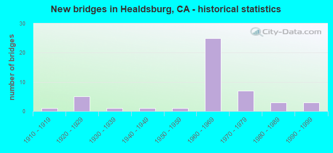
- New bridges - historical statistics
- 11910-1919
- 51920-1929
- 11930-1939
- 11940-1949
- 11950-1959
- 251960-1969
- 71970-1979
- 31980-1989
- 31990-1999

- Reconstructed bridges - Historical Statistics
- 21960-1969
- 21970-1979
- 01980-1989
- 01990-1999
- 12000-2009
- 12010-2019


- Bridge Condition - Deck
- 37.1%Good
- 14.3%Satisfactory
- 40.0%Fair
- 8.6%Poor

- Bridge Condition - Superstructure
- 60.0%Good
- 2.9%Satisfactory
- 37.1%Fair

- Bridge Condition - Substructure
- 65.7%Good
- 2.9%Satisfactory
- 28.6%Fair
- 2.9%Poor

- Bridge Condition - Channel
- 15.0%Excellent
- 10.0%Very good
- 55.0%Good
- 10.0%Satisfactory
- 10.0%Fair

- Bridge Condition - Culverts
- 33.3%Good
- 66.7%Satisfactory
Find on map >> Show street view
Structure Number: 20 0144, Location: 04-SON-101-36.27 (Lat: 38.626025, Lng: -122.878028), Route carried "under" structure: City street , Year Built: 1960, Structure Length: 0. m, Average Daily Traffic: 650 (year 2014), Truck Traffic: 1%, Features Intersected: DRY CREEK ROAD, Facility Carried by Structure: US HIGHWAY 101
Minimum Vertical Clearance: 4.97m (16.31ft), Kilometerpoint: 0.000, Lanes on structure: 4, Lanes under structure: 2, Material/Design: Concrete continuous, Design/Construction: Box Beam or Girders - Multiple, Length of Maximum Span: 26.5m (86.9ft)
Find on map >> Show street view
Structure Number: 20 0146L, Location: 04-SON-101-36.95 (Lat: 38.635886, Lng: -122.877558), Route carried "under" structure: City street , Year Built: 1960, Structure Length: 0. m, Average Daily Traffic: 800 (year 2010), Truck Traffic: 1%, Features Intersected: CHIQUITA ROAD, Facility Carried by Structure: US HIGHWAY 101 SB
Minimum Vertical Clearance: 4.90m (16.08ft), Kilometerpoint: 0.000, Lanes on structure: 2, Lanes under structure: 2, Material/Design: Concrete continuous, Design/Construction: Tee Beam, Length of Maximum Span: 18.9m (62.0ft)
Find on map >> Show street view
Structure Number: 20 0146R, Location: 04-SON-101-36.95 (Lat: 38.635800, Lng: -122.877392), Route carried "under" structure: City street , Year Built: 1960, Structure Length: 0. m, Average Daily Traffic: 1,000 (year 2017), Truck Traffic: 1%, Features Intersected: CHIQUITA ROAD, Facility Carried by Structure: US HIGHWAY 101 NB
Minimum Vertical Clearance: 5.08m (16.67ft), Kilometerpoint: 0.000, Lanes on structure: 2, Lanes under structure: 2, Material/Design: Concrete continuous, Design/Construction: Tee Beam, Length of Maximum Span: 18.9m (62.0ft)
Find on map >> Show street view
Structure Number: 20 0147, Location: 04-SON-101-34.88 (Lat: 38.607158, Lng: -122.872703), Route carried "under" structure: City street , Year Built: 1960, Structure Length: 0. m, Average Daily Traffic: 1,000 (year 2017), Truck Traffic: 6%, Features Intersected: WESTSIDE RD, Facility Carried by Structure: U.S. HIGHWAY 101
Minimum Vertical Clearance: 4.44m (14.57ft), Kilometerpoint: 0.000, Lanes on structure: 4, Lanes under structure: 2, Material/Design: Concrete continuous, Design/Construction: Box Beam or Girders - Multiple, Length of Maximum Span: 28.0m (91.9ft)