Bridge Statistics for Fremont, California (CA)
Condition, Traffic, Stress, Structural Evaluation, Project Costs
- National Bridge Inventory (NBI) Statistics
- 138Number of bridges
- 2,103ft / 641mTotal length
- $17,179,000Total costs
- 8,418,736Total average daily traffic
- 644,736Total average daily truck traffic
- National Bridge Inventory (NBI) Registered Bridges for Fremont
- No street view available for this location
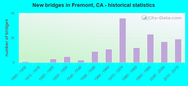
- New bridges - historical statistics
- 11900-1909
- 31920-1929
- 51930-1939
- 21940-1949
- 91950-1959
- 111960-1969
- 361970-1979
- 121980-1989
- 231990-1999
- 172000-2009
- 192010-2019

- Reconstructed bridges - Historical Statistics
- 11960-1969
- 11970-1979
- 31980-1989
- 141990-1999
- 32000-2009
- 52010-2019


- Bridge Condition - Deck
- 34.3%Good
- 20.0%Satisfactory
- 31.4%Fair
- 14.3%Poor

- Bridge Condition - Superstructure
- 75.7%Good
- 1.4%Satisfactory
- 22.9%Fair

- Bridge Condition - Substructure
- 88.6%Good
- 4.3%Satisfactory
- 7.1%Fair

- Bridge Condition - Channel
- 12.9%Excellent
- 29.0%Very good
- 54.8%Good
- 3.2%Satisfactory

- Bridge Condition - Culverts
- 33.3%Good
- 44.4%Satisfactory
- 11.1%Fair
- 11.1%Poor
Find on map >> Show street view
Structure Number: 33 0002, Location: 04-ALA-238-2.19-FMT (Lat: 37.559672, Lng: -121.955625), Route carried "under" structure: State highway 238, Year Built: 1921, Structure Length: 0. m, Average Daily Traffic: 112,000 (year 2010), Truck Traffic: 4%, Features Intersected: STATE ROUTE 238, Facility Carried by Structure: UP RR & BARTD
Minimum Vertical Clearance: 4.26m (13.98ft), Kilometerpoint: 2.190, Lanes under structure: 4, Material/Design: Steel, Design/Construction: Stringer/Multi-beam, Length of Maximum Span: 12.2m (40.0ft)
Find on map >> Show street view
Structure Number: 33 003, Location: 04-ALA-084-10.71-FMT (Lat: 37.571556, Lng: -121.969497), Route carried "under" structure: State highway 84, Year Built: 1937, Structure Length: 0. m, Average Daily Traffic: 22,400 (year 2009), Truck Traffic: 2%, Features Intersected: STATE ROUTE 84, Facility Carried by Structure: UP RR,BNSF,AMTRAK
Minimum Vertical Clearance: 4.62m (15.16ft), Kilometerpoint: 10.710, Lanes under structure: 2, Material/Design: Steel, Design/Construction: Girder and Floorbeam System, Length of Maximum Span: 12.8m (42.0ft)
Find on map >> Show street view
Structure Number: 33 0034, Location: 04-ALA-084-12.10-FMT (Lat: 37.589633, Lng: -121.957686), Route carried "under" structure: State highway 84, Year Built: 1906, Structure Length: 0. m, Average Daily Traffic: 14,850 (year 2009), Truck Traffic: 2%, Features Intersected: STATE ROUTE 84, Facility Carried by Structure: UP RR SPUR
Minimum Vertical Clearance: 4.41m (14.47ft), Kilometerpoint: 12.100, Lanes under structure: 2, Material/Design: Steel, Design/Construction: Stringer/Multi-beam, Length of Maximum Span: 18.0m (59.1ft)
Find on map >> Show street view
Structure Number: 33 0035, Location: 04-ALA-084-13.03 (Lat: 37.597753, Lng: -121.946525), Route carried "under" structure: State highway 84, Year Built: 1932, Structure Length: 0. m, Average Daily Traffic: 14,850 (year 2009), Truck Traffic: 2%, Features Intersected: STATE ROUTE 84, Facility Carried by Structure: UP RR SPUR
Minimum Vertical Clearance: 4.54m (14.90ft), Kilometerpoint: 13.030, Lanes under structure: 2, Material/Design: Steel, Design/Construction: Stringer/Multi-beam, Length of Maximum Span: 21.0m (68.9ft)
Find on map >> Show street view
Structure Number: 33 0053, Location: 04-ALA-084-10.63-FMT (Lat: 37.570342, Lng: -121.970014), Route carried "under" structure: State highway 84, Year Built: 1937, Structure Length: 0. m, Average Daily Traffic: 22,400 (year 2010), Truck Traffic: 4%, Features Intersected: STATE ROUTE 84, Facility Carried by Structure: UP RR
Minimum Vertical Clearance: 4.72m (15.49ft), Kilometerpoint: 10.630, Lanes under structure: 2, Material/Design: Steel, Design/Construction: Girder and Floorbeam System, Length of Maximum Span: 13.1m (43.0ft)
Find on map >> Show street view
Structure Number: 33 0237, Location: 04-ALA-880-3.25-FMT (Lat: 37.492111, Lng: -121.947506), Route carried "under" structure: Interstate 880, Year Built: 1995, Structure Length: 0. m, Average Daily Traffic: 161,000 (year 2017), Truck Traffic: 5%, Features Intersected: INTERSTATE 880, Facility Carried by Structure: FREMONT BOULEVARD
Minimum Vertical Clearance: 5.60m (18.37ft), Kilometerpoint: 3.250, Lanes on structure: 7, Lanes under structure: 10, Material/Design: Prestressed concrete continuous, Design/Construction: Box Beam or Girders - Multiple, Length of Maximum Span: 49.2m (161.4ft)
Find on map >> Show street view
Structure Number: 33 0243, Location: 04-ALA-084-R5.98-FMT (Lat: 37.563064, Lng: -122.038628), Route carried "under" structure: Interstate 880, Year Built: 1984, Structure Length: 0. m, Average Daily Traffic: 189,000 (year 2010), Truck Traffic: 11%, Features Intersected: INTERSTATE 880, Facility Carried by Structure: STATE ROUTE 84
Minimum Vertical Clearance: 5.66m (18.57ft), Kilometerpoint: 10.300, Lanes on structure: 6, Lanes under structure: 10, Material/Design: Prestressed concrete continuous, Design/Construction: Box Beam or Girders - Multiple, Length of Maximum Span: 46.0m (150.9ft)
Find on map >> Show street view
Structure Number: 33 0261L, Location: 04-ALA-880-8.25-FMT (Lat: 37.538989, Lng: -122.017572), Route carried "under" structure: Interstate 880, Year Built: 1993, Structure Length: 0. m, Average Daily Traffic: 197,000 (year 2017), Truck Traffic: 11%, Features Intersected: INTERSTATE 880, Facility Carried by Structure: CENTRAL AVE SB
Minimum Vertical Clearance: 5.90m (19.36ft), Kilometerpoint: 8.250, Lanes on structure: 2, Lanes under structure: 9, Material/Design: Prestressed concrete continuous, Design/Construction: Box Beam or Girders - Multiple, Length of Maximum Span: 42.4m (139.1ft)
Find on map >> Show street view
Structure Number: 33 0261R, Location: 04-ALA-880-8.24-FMT (Lat: 37.538856, Lng: -122.017469), Route carried "under" structure: Interstate 880, Year Built: 1993, Structure Length: 0. m, Average Daily Traffic: 197,000 (year 2019), Truck Traffic: 11%, Features Intersected: INTERSTATE 880, Facility Carried by Structure: CENTRAL AVE NB
Minimum Vertical Clearance: 5.42m (17.78ft), Kilometerpoint: 8.240, Lanes on structure: 2, Lanes under structure: 9, Material/Design: Prestressed concrete continuous, Design/Construction: Box Beam or Girders - Multiple, Length of Maximum Span: 42.4m (139.1ft)
Find on map >> Show street view
Structure Number: 33 0262, Location: 04-ALA-880-8.54-FMT (Lat: 37.542433, Lng: -122.020189), Route carried "under" structure: Interstate 880, Year Built: 1995, Structure Length: 0. m, Average Daily Traffic: 187,000 (year 2009), Truck Traffic: 7%, Features Intersected: INTERSTATE 880, Facility Carried by Structure: UP RR, AMTRAK, ACE
Minimum Vertical Clearance: 5.39m (17.68ft), Kilometerpoint: 8.540, Lanes under structure: 10, Material/Design: Steel continuous, Design/Construction: Girder and Floorbeam System, Length of Maximum Span: 42.8m (140.4ft)
Find on map >> Show street view
Structure Number: 33 0264, Location: 04-ALA-084-6.93-FMT (Lat: 37.546175, Lng: -122.023056), Route carried "under" structure: Interstate 880, Year Built: 1997, Structure Length: 0. m, Average Daily Traffic: 200,000 (year 2010), Truck Traffic: 13%, Features Intersected: INTERSTATE 880, Facility Carried by Structure: SR 84 (THORNTON)
Minimum Vertical Clearance: 5.60m (18.37ft), Kilometerpoint: 8.840, Lanes on structure: 6, Lanes under structure: 10, Material/Design: Prestressed concrete continuous, Design/Construction: Box Beam or Girders - Multiple, Length of Maximum Span: 48.1m (157.8ft)
Find on map >> Show street view
Structure Number: 33 0267L, Location: 04-ALA-880-7.19-FMT (Lat: 37.529497, Lng: -122.002531), Route carried "under" structure: Interstate 880, Year Built: 1994, Structure Length: 0. m, Average Daily Traffic: 187,000 (year 2017), Truck Traffic: 7%, Features Intersected: INTERSTATE 880, Facility Carried by Structure: MOWRY AVENUE WB
Minimum Vertical Clearance: 5.38m (17.65ft), Kilometerpoint: 7.190, Lanes on structure: 4, Lanes under structure: 10, Material/Design: Prestressed concrete continuous, Design/Construction: Box Beam or Girders - Multiple, Length of Maximum Span: 39.3m (128.9ft)
Find on map >> Show street view
Structure Number: 33 0267R, Location: 04-ALA-880-7.18-FMT (Lat: 37.529389, Lng: -122.002336), Route carried "under" structure: Interstate 880, Year Built: 1994, Structure Length: 0. m, Average Daily Traffic: 187,000 (year 2017), Truck Traffic: 7%, Features Intersected: INTERSTATE 880, Facility Carried by Structure: MOWRY AVENUE EB
Minimum Vertical Clearance: 5.73m (18.80ft), Kilometerpoint: 7.180, Lanes on structure: 4, Lanes under structure: 10, Material/Design: Prestressed concrete continuous, Design/Construction: Box Beam or Girders - Multiple, Length of Maximum Span: 40.0m (131.2ft)
Find on map >> Show street view
Structure Number: 33 0268, Location: 04-ALA-880-4.71-FMT (Lat: 37.507081, Lng: -121.967672), Route carried "under" structure: Interstate 880, Year Built: 1994, Structure Length: 0. m, Average Daily Traffic: 161,000 (year 2017), Truck Traffic: 5%, Features Intersected: INTERSTATE 880, Facility Carried by Structure: AUTO MALL PARKWAY
Minimum Vertical Clearance: 5.74m (18.83ft), Kilometerpoint: 4.710, Lanes on structure: 8, Lanes under structure: 10, Material/Design: Prestressed concrete continuous, Design/Construction: Box Beam or Girders - Multiple, Length of Maximum Span: 43.6m (143.0ft)
Find on map >> Show street view
Structure Number: 33 0286, Location: 04-ALA-880-8.52-FMT (Lat: 37.542828, Lng: -122.019689), Route carried "under" structure: Interstate 880, Year Built: 1958, Structure Length: 0. m, Average Daily Traffic: 187,000 (year 2009), Truck Traffic: 7%, Features Intersected: INTERSTATE 880, Facility Carried by Structure: PG&E PIPELINE
Minimum Vertical Clearance: 6.40m (21.00ft), Kilometerpoint: 8.520, Lanes under structure: 10, Length of Maximum Span: 32.3m (106.0ft)
Find on map >> Show street view
Structure Number: 33 0294, Location: 04-ALA-680-R6.38-FMT (Lat: 37.540306, Lng: -121.924547), Route carried "under" structure: State highway 238, Year Built: 1963, Structure Length: 0. m, Average Daily Traffic: 27,000 (year 2018), Truck Traffic: 3%, Features Intersected: SR 238 (MISSION BLVD), Facility Carried by Structure: INTERSTATE 680
Minimum Vertical Clearance: 4.47m (14.67ft), Kilometerpoint: 0.010, Lanes on structure: 8, Lanes under structure: 5, Material/Design: Concrete continuous, Design/Construction: Box Beam or Girders - Multiple, Length of Maximum Span: 27.7m (90.9ft)
Find on map >> Show street view
Structure Number: 33 036, Location: 04-ALA-680-M5.91-FMT (Lat: 37.535569, Lng: -121.933572), Route carried "under" structure: Interstate 680, Year Built: 1971, Structure Length: 0. m, Average Daily Traffic: 140,000 (year 2018), Truck Traffic: 9%, Features Intersected: INTERSTATE 680, Facility Carried by Structure: PALM AVE
Minimum Vertical Clearance: 5.35m (17.55ft), Kilometerpoint: 5.910, Lanes on structure: 2, Lanes under structure: 7, Material/Design: Prestressed concrete continuous, Design/Construction: Box Beam or Girders - Multiple, Length of Maximum Span: 36.0m (118.1ft)
Find on map >> Show street view
Structure Number: 33 0361, Location: 04-ALA-680-M5.37-FMT (Lat: 37.531064, Lng: -121.942278), Route carried "under" structure: Interstate 680, Year Built: 1971, Structure Length: 0. m, Average Daily Traffic: 140,000 (year 2018), Truck Traffic: 9%, Features Intersected: INTERSTATE 680, Facility Carried by Structure: WASHINGTON BLVD
Minimum Vertical Clearance: 5.53m (18.14ft), Kilometerpoint: 5.370, Lanes on structure: 4, Lanes under structure: 8, Material/Design: Prestressed concrete continuous, Design/Construction: Box Beam or Girders - Multiple, Length of Maximum Span: 52.3m (171.6ft)
Find on map >> Show street view
Structure Number: 33 0368, Location: 04-ALA-680-M4.02-FMT (Lat: 37.514406, Lng: -121.940133), Route carried "under" structure: Interstate 680, Year Built: 1971, Structure Length: 0. m, Average Daily Traffic: 140,000 (year 2018), Truck Traffic: 9%, Features Intersected: INTERSTATE 680, Facility Carried by Structure: AUTO MALL PARKWAY
Minimum Vertical Clearance: 4.87m (15.98ft), Kilometerpoint: 4.020, Lanes on structure: 4, Lanes under structure: 10, Material/Design: Prestressed concrete continuous, Design/Construction: Box Beam or Girders - Multiple, Length of Maximum Span: 43.9m (144.0ft)
Find on map >> Show street view
Structure Number: 33 0405, Location: 04-ALA-680-M5.67-FMT (Lat: 37.533592, Lng: -121.937431), Route carried "under" structure: Interstate 680, Year Built: 1971, Structure Length: 0. m, Average Daily Traffic: 140,000 (year 2018), Truck Traffic: 9%, Features Intersected: INTERSTATE 680, Facility Carried by Structure: PASEO PADRE PKWY
Minimum Vertical Clearance: 5.18m (16.99ft), Kilometerpoint: 5.670, Lanes on structure: 4, Lanes under structure: 8, Material/Design: Concrete continuous, Design/Construction: Box Beam or Girders - Multiple, Length of Maximum Span: 37.8m (124.0ft)
Find on map >> Show street view
Structure Number: 33 0424L, Location: 04-ALA-680-M0.13-FMT (Lat: 37.466311, Lng: -121.905147), Route carried "under" structure: City street , Year Built: 1971, Structure Length: 0. m, Average Daily Traffic: 9,500 (year 2018), Truck Traffic: 1%, Features Intersected: SCOTT CREEK RD, Facility Carried by Structure: INTERSTATE 680 SB
Minimum Vertical Clearance: 5.81m (19.06ft), Kilometerpoint: 0.000, Lanes on structure: 4, Lanes under structure: 3, Material/Design: Concrete continuous, Design/Construction: Box Beam or Girders - Multiple, Length of Maximum Span: 26.6m (87.3ft)
Find on map >> Show street view
Structure Number: 33 0424R, Location: 04-ALA-680-M0.13-FMT (Lat: 37.466247, Lng: -121.905572), Route carried "under" structure: City street , Year Built: 1971, Structure Length: 0. m, Average Daily Traffic: 9,500 (year 2018), Truck Traffic: 1%, Features Intersected: SCOTT CREEK RD, Facility Carried by Structure: INTERSTATE 680 NB
Minimum Vertical Clearance: 5.18m (16.99ft), Kilometerpoint: 0.000, Lanes on structure: 4, Lanes under structure: 2, Material/Design: Concrete continuous, Design/Construction: Box Beam or Girders - Multiple, Length of Maximum Span: 27.5m (90.2ft)
Find on map >> Show street view
Structure Number: 33 0428L, Location: 04-ALA-680-M2.38-FMT (Lat: 37.495575, Lng: -121.922700), Route carried "under" structure: State highway 262, Year Built: 1971, Structure Length: 0. m, Average Daily Traffic: 76,000 (year 2018), Truck Traffic: 8%, Features Intersected: SR 262 (MISSION BLVD), Facility Carried by Structure: INTERSTATE 680 SB
Minimum Vertical Clearance: 6.78m (22.24ft), Kilometerpoint: 1.070, Lanes on structure: 6, Lanes under structure: 6, Material/Design: Concrete continuous, Design/Construction: Box Beam or Girders - Multiple, Length of Maximum Span: 26.5m (86.9ft)
Find on map >> Show street view
Structure Number: 33 0428R, Location: 04-ALA-680-M2.38-FMT (Lat: 37.495353, Lng: -121.923028), Route carried "under" structure: State highway 262, Year Built: 1971, Structure Length: 0. m, Average Daily Traffic: 76,000 (year 2018), Truck Traffic: 8%, Features Intersected: SR 262 (MISSION BLVD), Facility Carried by Structure: INTERSTATE 680 NB
Minimum Vertical Clearance: 4.93m (16.17ft), Kilometerpoint: 1.070, Lanes on structure: 5, Lanes under structure: 6, Material/Design: Concrete continuous, Design/Construction: Box Beam or Girders - Multiple, Length of Maximum Span: 26.5m (86.9ft)
Find on map >> Show street view
Structure Number: 33 0429L, Location: 04-ALA-680-M3.35-FMT (Lat: 37.506000, Lng: -121.934325), Route carried "under" structure: City street , Year Built: 1971, Structure Length: 0. m, Average Daily Traffic: 10,000 (year 2018), Truck Traffic: 1%, Features Intersected: GRIMMER BLVD, Facility Carried by Structure: INTERSTATE 680 SB
Minimum Vertical Clearance: 4.87m (15.98ft), Kilometerpoint: 0.000, Lanes on structure: 5, Lanes under structure: 2, Material/Design: Prestressed concrete, Design/Construction: Box Beam or Girders - Multiple, Length of Maximum Span: 44.8m (147.0ft)
Find on map >> Show street view
Structure Number: 33 0429R, Location: 04-ALA-680-M3.35-FMT (Lat: 37.506206, Lng: -121.934553), Route carried "under" structure: City street , Year Built: 1971, Structure Length: 0. m, Average Daily Traffic: 10,000 (year 2018), Truck Traffic: 1%, Features Intersected: GRIMMER BLVD, Facility Carried by Structure: INTERSTATE 680 NB
Minimum Vertical Clearance: 4.39m (14.40ft), Kilometerpoint: 0.000, Lanes on structure: 3, Lanes under structure: 2, Material/Design: Prestressed concrete, Design/Construction: Box Beam or Girders - Multiple, Length of Maximum Span: 44.8m (147.0ft)
Find on map >> Show street view
Structure Number: 33 0475, Location: 04-ALA-084-9.66-FMT (Lat: 37.563653, Lng: -121.984511), Route carried "under" structure: State highway 84, Year Built: 1970, Structure Length: 0. m, Average Daily Traffic: 22,400 (year 2009), Truck Traffic: 2%, Features Intersected: STATE ROUTE 84, Facility Carried by Structure: BARTD
Minimum Vertical Clearance: 4.72m (15.49ft), Kilometerpoint: 9.660, Lanes under structure: 4, Material/Design: Prestressed concrete, Design/Construction: Stringer/Multi-beam, Length of Maximum Span: 38.4m (126.0ft)
Find on map >> Show street view
Structure Number: 33 0515, Location: 04-ALA-880-10.93-FMT (Lat: 37.570619, Lng: -122.045625), Route carried "under" structure: Interstate 880, Year Built: 1981, Structure Length: 0. m, Average Daily Traffic: 220,000 (year 2017), Truck Traffic: 11%, Features Intersected: INTERSTATE 880, Facility Carried by Structure: PASEO PADRE PKWY
Minimum Vertical Clearance: 5.07m (16.63ft), Kilometerpoint: 10.930, Lanes on structure: 4, Lanes under structure: 9, Material/Design: Prestressed concrete continuous, Design/Construction: Stringer/Multi-beam, Length of Maximum Span: 30.5m (100.1ft)
Find on map >> Show street view
Structure Number: 33 0518, Location: 04-ALA-084-R3.21-FMT (Lat: 37.535747, Lng: -122.075283), Route carried "under" structure: State highway 84, Year Built: 1986, Structure Length: 0. m, Average Daily Traffic: 63,000 (year 2020), Truck Traffic: 6%, Features Intersected: STATE ROUTE 84, Facility Carried by Structure: DUMBARTON TL POC
Minimum Vertical Clearance: 5.51m (18.08ft), Kilometerpoint: 3.210, Lanes under structure: 11, Material/Design: Prestressed concrete continuous, Design/Construction: Box Beam or Girders - Multiple, Length of Maximum Span: 56.4m (185.0ft)
Find on map >> Show street view
Structure Number: 33 0591, Location: 04-ALA-880-6.24-FMT (Lat: 37.522050, Lng: -121.987686), Route carried "under" structure: Interstate 880, Year Built: 1997, Structure Length: 0. m, Average Daily Traffic: 187,000 (year 2017), Truck Traffic: 7%, Features Intersected: INTERSTATE 880, Facility Carried by Structure: STEVENSON BLVD
Minimum Vertical Clearance: 5.72m (18.77ft), Kilometerpoint: 6.240, Lanes on structure: 8, Lanes under structure: 10, Material/Design: Prestressed concrete continuous, Design/Construction: Box Beam or Girders - Multiple, Length of Maximum Span: 41.5m (136.2ft)
Find on map >> Show street view
Structure Number: 33 0618, Location: 04-ALA-880-11.50-FMT (Lat: 37.578647, Lng: -122.048658), Route carried "under" structure: Interstate 880, Year Built: 1998, Structure Length: 0. m, Average Daily Traffic: 198,000 (year 2017), Truck Traffic: 11%, Features Intersected: INTERSTATE 880, Facility Carried by Structure: FREMONT BOULEVARD
Minimum Vertical Clearance: 5.36m (17.59ft), Kilometerpoint: 11.500, Lanes on structure: 8, Lanes under structure: 9, Material/Design: Prestressed concrete continuous, Design/Construction: Box Beam or Girders - Multiple, Length of Maximum Span: 52.7m (172.9ft)
Find on map >> Show street view
Structure Number: 33 0665F, Location: 04-ALA-880-2.48-FMT (Lat: 37.480950, Lng: -121.935625), Route carried "under" structure: Ramp Interstate 880, Year Built: 2008, Structure Length: 0. m, Average Daily Traffic: 81,000 (year 1998), Truck Traffic: 6%, Features Intersected: I 880, WARREN AVE, RAMPS
Minimum Vertical Clearance: 6.60m (21.65ft), Kilometerpoint: 2.480, Lanes on structure: 3, Lanes under structure: 2, Material/Design: Concrete continuous, Design/Construction: Box Beam or Girders - Multiple, Length of Maximum Span: 64.5m (211.6ft)
Find on map >> Show street view
Structure Number: 33 0665F, Location: 04-ALA-880-2.48-FMT (Lat: 37.480950, Lng: -121.935625), Route carried "under" structure: Interstate 880, Year Built: 2008, Structure Length: 0. m, Average Daily Traffic: 153,000 (year 2000), Truck Traffic: 10%, Features Intersected: I 880, WARREN AVE, RAMPS
Minimum Vertical Clearance: 15.03m (49.31ft), Kilometerpoint: 2.480, Lanes on structure: 3, Lanes under structure: 4, Material/Design: Concrete continuous, Design/Construction: Box Beam or Girders - Multiple, Length of Maximum Span: 64.5m (211.6ft)
Find on map >> Show street view
Structure Number: 33 0665F, Location: 04-ALA-880-2.48-FMT (Lat: 37.480950, Lng: -121.935625), Route carried "under" structure: Interstate 880, Year Built: 2008, Structure Length: 0. m, Average Daily Traffic: 153,000 (year 2000), Truck Traffic: 10%, Features Intersected: I 880, WARREN AVE, RAMPS
Minimum Vertical Clearance: 15.50m (50.85ft), Kilometerpoint: 2.480, Lanes on structure: 3, Lanes under structure: 5, Material/Design: Concrete continuous, Design/Construction: Box Beam or Girders - Multiple, Length of Maximum Span: 64.5m (211.6ft)
Find on map >> Show street view
Structure Number: 33 0665F, Location: 04-ALA-880-2.48-FMT (Lat: 37.480950, Lng: -121.935625), Route carried "under" structure: Ramp Interstate 880, Year Built: 2008, Structure Length: 0. m, Average Daily Traffic: 153,000 (year 2000), Truck Traffic: 10%, Features Intersected: I 880, WARREN AVE, RAMPS
Minimum Vertical Clearance: 15.30m (50.20ft), Kilometerpoint: 2.480, Lanes on structure: 3, Lanes under structure: 2, Material/Design: Concrete continuous, Design/Construction: Box Beam or Girders - Multiple, Length of Maximum Span: 64.5m (211.6ft)
Find on map >> Show street view
Structure Number: 33 0666F, Location: 04-ALA-880-2.55-FMT (Lat: 37.484094, Lng: -121.938067), Route carried "under" structure: Interstate 880, Year Built: 2009, Structure Length: 0. m, Average Daily Traffic: 170,000 (year 2017), Truck Traffic: 11%, Features Intersected: INTERSTATE 880
Minimum Vertical Clearance: 5.41m (17.75ft), Kilometerpoint: 2.550, Lanes on structure: 2, Lanes under structure: 10, Material/Design: Prestressed concrete continuous, Design/Construction: Box Beam or Girders - Multiple, Length of Maximum Span: 41.8m (137.1ft)
Find on map >> Show street view
Structure Number: 33 0667, Location: 04-ALA-880-2.51-FMT (Lat: 37.483422, Lng: -121.937528), Route carried "under" structure: Interstate 880, Year Built: 2009, Structure Length: 0. m, Average Daily Traffic: 170,000 (year 2017), Truck Traffic: 11%, Features Intersected: INTERSTATE 880, Facility Carried by Structure: WARREN AVENUE
Minimum Vertical Clearance: 5.13m (16.83ft), Kilometerpoint: 2.510, Lanes on structure: 4, Lanes under structure: 13, Material/Design: Concrete continuous, Design/Construction: Box Beam or Girders - Multiple, Length of Maximum Span: 28.9m (94.8ft)
Find on map >> Show street view
Structure Number: 33 0668, Location: 04-ALA-880-2.29-FMT (Lat: 37.484111, Lng: -121.934958), Route carried "under" structure: Ramp Interstate 880, Year Built: 2009, Structure Length: 0. m, Average Daily Traffic: 40,000 (year 2017), Truck Traffic: 11%, Features Intersected: N880-E262 CONNECTOR RAMP, Facility Carried by Structure: WARREN AVENUE
Minimum Vertical Clearance: 5.51m (18.08ft), Kilometerpoint: 2.290, Lanes on structure: 5, Lanes under structure: 2, Material/Design: Concrete, Design/Construction: Slab, Length of Maximum Span: 34.1m (111.9ft)
Find on map >> Show street view
Structure Number: 33 0669, Location: 04-ALA-262-R0.28 (Lat: 37.486267, Lng: -121.933806), Route carried "under" structure: State highway 262, Year Built: 2008, Structure Length: 0. m, Average Daily Traffic: 76,000 (year 2009), Truck Traffic: 8%, Features Intersected: ST RTE 262 (MISSION BL), Facility Carried by Structure: KATO ROAD
Minimum Vertical Clearance: 6.33m (20.77ft), Kilometerpoint: 0.280, Lanes on structure: 3, Lanes under structure: 5, Material/Design: Concrete continuous, Design/Construction: Box Beam or Girders - Multiple, Length of Maximum Span: 45.2m (148.3ft)
Find on map >> Show street view
Structure Number: 33 0705, Location: 04-ALA-262-R0.43-FMT (Lat: 37.487711, Lng: -121.932294), Route carried "under" structure: State highway 262, Year Built: 2015, Structure Length: 0. m, Average Daily Traffic: 76,000 (year 2009), Truck Traffic: 8%, Features Intersected: STATE RTE 262 MISSION BL, Facility Carried by Structure: UP RR, BNSF RY
Minimum Vertical Clearance: 5.23m (17.16ft), Kilometerpoint: 0.430, Lanes under structure: 8, Material/Design: Steel, Design/Construction: Girder and Floorbeam System, Length of Maximum Span: 40.4m (132.5ft)
Find on map >> Show street view
Structure Number: 33 0706, Location: 04-ALA-262-R0.45-FMT (Lat: 37.487983, Lng: -121.932025), Route carried "under" structure: State highway 262, Year Built: 2015, Structure Length: 0. m, Average Daily Traffic: 76,000 (year 2009), Truck Traffic: 8%, Features Intersected: STATE RTE 262 MISSION BL, Facility Carried by Structure: RR TRACKS (BARTD)
Minimum Vertical Clearance: 5.66m (18.57ft), Kilometerpoint: 0.450, Lanes under structure: 8, Material/Design: Prestressed concrete continuous, Design/Construction: Box Beam or Girders - Multiple, Length of Maximum Span: 36.0m (118.1ft)
Find on map >> Show street view
Structure Number: 33 0727, Location: 04-ALA-238-3.77-FMT (Lat: 37.577589, Lng: -121.973667), Route carried "under" structure: State highway 238, Year Built: 2006, Structure Length: 0. m, Average Daily Traffic: 27,000 (year 2009), Truck Traffic: 3%, Features Intersected: STATE ROUTE 238, Facility Carried by Structure: UP RR SPUR
Minimum Vertical Clearance: 4.67m (15.32ft), Kilometerpoint: 3.770, Lanes under structure: 5, Material/Design: Steel continuous, Design/Construction: Girder and Floorbeam System, Length of Maximum Span: 24.5m (80.4ft)
Find on map >> Show street view
Structure Number: 33 0728, Location: 04-ALA-238-3.40-FMT (Lat: 37.573547, Lng: -121.969114), Route carried "under" structure: State highway 238, Year Built: 2006, Structure Length: 0. m, Average Daily Traffic: 10,000 (year 2010), Truck Traffic: 5%, Features Intersected: STATE ROUTE 238, Facility Carried by Structure: UP RR & BNSF RY
Minimum Vertical Clearance: 4.65m (15.26ft), Kilometerpoint: 3.400, Lanes under structure: 4, Material/Design: Steel, Design/Construction: Girder and Floorbeam System, Length of Maximum Span: 37.5m (123.0ft)
Find on map >> Show street view
Structure Number: 33C0014, Location: 0.15 MI SW OF ST RTE 238 (Lat: 37.574978, Lng: -121.973461), Route carried "under" structure: City street , Year Built: 1937, Structure Length: 0. m, Average Daily Traffic: 5,200 (year 2010), Truck Traffic: 1%, Features Intersected: NILES BLVD, Facility Carried by Structure: UP RR,BNSF,AMTRAK
Minimum Vertical Clearance: 4.16m (13.65ft), Kilometerpoint: 0.000, Lanes under structure: 2, Material/Design: Steel, Design/Construction: Stringer/Multi-beam, Length of Maximum Span: 12.2m (40.0ft)
Find on map >> Show street view
Structure Number: 33C004, Location: 0.5 MI SW/O ALVARADO BLVD (Lat: 37.574797, Lng: -122.060408), Route carried "under" structure: City street , Year Built: 1960, Structure Length: 0. m, Average Daily Traffic: 9,300 (year 2010), Truck Traffic: 2%, Features Intersected: LOWRY RD, Facility Carried by Structure: UP RR
Minimum Vertical Clearance: 4.60m (15.09ft), Kilometerpoint: 0.000, Lanes under structure: 2, Material/Design: Prestressed concrete, Design/Construction: Stringer/Multi-beam, Length of Maximum Span: 16.2m (53.1ft)
Find on map >> Show street view
Structure Number: 33C0139, Location: 0.1 MI E/O WARM SPRGS BL (Lat: 37.504353, Lng: -121.940939), Route carried "under" structure: City street , Year Built: 1979, Structure Length: 0. m, Average Daily Traffic: 12,300 (year 2010), Truck Traffic: 5%, Features Intersected: GRIMMER BLVD, Facility Carried by Structure: UP RR & BNSF RY
Minimum Vertical Clearance: 4.67m (15.32ft), Kilometerpoint: 0.000, Lanes under structure: 4, Material/Design: Concrete continuous, Design/Construction: Box Beam or Girders - Multiple, Length of Maximum Span: 25.0m (82.0ft)
Find on map >> Show street view
Structure Number: 33C014, Location: 0.1 MI E/O WARM SPRGS BL (Lat: 37.504422, Lng: -121.940431), Route carried "under" structure: City street , Year Built: 1979, Structure Length: 0. m, Average Daily Traffic: 12,300 (year 2010), Truck Traffic: 5%, Features Intersected: GRIMMER BLVD, Facility Carried by Structure: UP RR
Minimum Vertical Clearance: 4.64m (15.22ft), Kilometerpoint: 0.000, Lanes under structure: 4, Material/Design: Concrete continuous, Design/Construction: Box Beam or Girders - Multiple, Length of Maximum Span: 25.0m (82.0ft)
Find on map >> Show street view
Structure Number: 33C0168L, Location: 0.1 MI NW/O PARKSIDE DR. (Lat: 37.559339, Lng: -121.979389), Route carried "under" structure: City street , Year Built: 1968, Structure Length: 0. m, Average Daily Traffic: 54,228 (year 2002), Truck Traffic: 10%, Features Intersected: MOWRY AVE, Facility Carried by Structure: BARTD
Minimum Vertical Clearance: 4.63m (15.19ft), Kilometerpoint: 0.000, Lanes under structure: 6, Material/Design: Prestressed concrete, Design/Construction: Box Beam or Girders - Multiple, Length of Maximum Span: 24.4m (80.1ft)
Find on map >> Show street view
Structure Number: 33C0168R, Location: 0.1 MI NW/O PARKSIDE DR. (Lat: 37.559417, Lng: -121.979347), Route carried "under" structure: City street , Year Built: 1968, Structure Length: 0. m, Average Daily Traffic: 54,228 (year 2002), Truck Traffic: 5%, Features Intersected: MOWRY AVE, Facility Carried by Structure: BARTD
Minimum Vertical Clearance: 4.63m (15.19ft), Kilometerpoint: 0.000, Lanes under structure: 6, Material/Design: Prestressed concrete, Design/Construction: Box Beam or Girders - Multiple, Length of Maximum Span: 24.4m (80.1ft)
Find on map >> Show street view
Structure Number: 33C0225, Location: 0.2 MI N/O PERALTA BLVD (Lat: 37.562911, Lng: -121.996333), Route carried "under" structure: City street , Year Built: 1975, Structure Length: 0. m, Average Daily Traffic: 28,500 (year 2010), Truck Traffic: 1%, Features Intersected: PASEO PADRE PARKWAY, Facility Carried by Structure: UP RR & BNSF RY
Minimum Vertical Clearance: 4.60m (15.09ft), Kilometerpoint: 0.000, Lanes under structure: 4, Material/Design: Concrete, Design/Construction: Box Beam or Girders - Multiple, Length of Maximum Span: 26.2m (86.0ft)
Find on map >> Show street view
Structure Number: 33C0418, Location: 0.5 MI W OF DRISCOLL RD (Lat: 37.541397, Lng: -121.955108), Route carried "under" structure: City street , Year Built: 2010, Structure Length: 0. m, Average Daily Traffic: 3,000 (year 2013), Truck Traffic: 2%, Features Intersected: PASEO PADRE PARKWAY, Facility Carried by Structure: UP RR
Minimum Vertical Clearance: 5.33m (17.49ft), Kilometerpoint: 0.000, Lanes under structure: 4, Material/Design: Prestressed concrete continuous, Design/Construction: Box Beam or Girders - Single/Spread, Length of Maximum Span: 16.6m (54.5ft)
Find on map >> Show street view
Structure Number: 33C0468, Location: 0.5 MI W OF DRISCOLL RD (Lat: 37.541192, Lng: -121.955797), Route carried "under" structure: City street , Year Built: 2010, Structure Length: 0. m, Average Daily Traffic: 3,000 (year 2013), Truck Traffic: 3%, Features Intersected: PASEO PADRE PARKWAY, Facility Carried by Structure: PEDESTRIAN ACCESS
Minimum Vertical Clearance: 4.57m (14.99ft), Kilometerpoint: 0.000, Lanes under structure: 4, Material/Design: Steel, Design/Construction: Truss - Thru, Length of Maximum Span: 39.0m (128.0ft)
Find on map >> Show street view
Structure Number: 33C047, Location: 0.5 MI W OF HWY680 (Lat: 37.541472, Lng: -121.954833), Route carried "under" structure: City street , Year Built: 2010, Structure Length: 0. m, Average Daily Traffic: 3,000 (year 2013), Truck Traffic: 2%, Features Intersected: PASEO PADRE PARKWAY, Facility Carried by Structure: BARTD (FUTURE)
Minimum Vertical Clearance: 5.66m (18.57ft), Kilometerpoint: 0.000, Lanes under structure: 4, Material/Design: Prestressed concrete continuous, Design/Construction: Box Beam or Girders - Multiple, Length of Maximum Span: 17.4m (57.1ft)
Find on map >> Show street view
Structure Number: 33C0478, Location: 0.3 MI W OF WARMSPRING BV (Lat: 37.462158, Lng: -121.919011), Route carried "under" structure: City street , Year Built: 2015, Structure Length: 0. m, Average Daily Traffic: 13,156 (year 2011), Truck Traffic: 5%, Features Intersected: KATO ROAD, Facility Carried by Structure: BARTD TRACKS
Minimum Vertical Clearance: 5.08m (16.67ft), Kilometerpoint: 0.000, Lanes under structure: 4, Material/Design: Prestressed concrete continuous, Design/Construction: Box Beam or Girders - Multiple, Length of Maximum Span: 13.8m (45.3ft)
Find on map >> Show street view
Structure Number: 33C0479, Location: 0.3 MI W OF WARMSPRING BV (Lat: 37.462133, Lng: -121.919100), Route carried "under" structure: City street , Year Built: 2015, Structure Length: 0. m, Average Daily Traffic: 13,156 (year 2011), Truck Traffic: 5%, Features Intersected: KATO ROAD, Facility Carried by Structure: UPRR ACCESS ROAD
Minimum Vertical Clearance: 5.15m (16.90ft), Kilometerpoint: 0.000, Lanes under structure: 4, Material/Design: Prestressed concrete continuous, Design/Construction: Box Beam or Girders - Single/Spread, Length of Maximum Span: 13.8m (45.3ft)
Find on map >> Show street view
Structure Number: 33C048, Location: 0.2 MI W OF WARMSPRING BV (Lat: 37.485878, Lng: -121.930856), Route carried "under" structure: City street , Year Built: 2015, Structure Length: 0. m, Average Daily Traffic: 16,288 (year 2013), Truck Traffic: 5%, Features Intersected: WARREN AVE, Facility Carried by Structure: BARTD TRACKS
Minimum Vertical Clearance: 5.30m (17.39ft), Kilometerpoint: 0.000, Lanes under structure: 4, Material/Design: Prestressed concrete, Design/Construction: Box Beam or Girders - Multiple, Length of Maximum Span: 27.6m (90.6ft)
Find on map >> Show street view
Structure Number: 33C0481, Location: 0.2 MI W OF WARMSPRING BV (Lat: 37.485847, Lng: -121.930994), Route carried "under" structure: City street , Year Built: 2015, Structure Length: 0. m, Average Daily Traffic: 16,288 (year 2013), Truck Traffic: 5%, Features Intersected: WARREN AVE, Facility Carried by Structure: UPRR ACCESS ROAD
Minimum Vertical Clearance: 5.43m (17.81ft), Kilometerpoint: 0.000, Lanes under structure: 4, Material/Design: Prestressed concrete, Design/Construction: Box Beam or Girders - Multiple, Length of Maximum Span: 27.6m (90.6ft)
Find on map >> Show street view
Structure Number: 33C0486, Location: 0.3 MI W OF WARMSPRING BV (Lat: 37.462114, Lng: -121.919178), Route carried "under" structure: City street , Year Built: 2012, Structure Length: 0. m, Average Daily Traffic: 13,156 (year 2011), Truck Traffic: 5%, Features Intersected: KATO ROAD, Facility Carried by Structure: UPRR TRACKS
Minimum Vertical Clearance: 5.23m (17.16ft), Kilometerpoint: 0.000, Lanes under structure: 4, Material/Design: Steel, Design/Construction: Stringer/Multi-beam, Length of Maximum Span: 13.8m (45.3ft)
Find on map >> Show street view
Structure Number: 33C0487, Location: 0.2 MI W OF WARMSPRING BV (Lat: 37.485781, Lng: -121.931261), Route carried "under" structure: City street , Year Built: 2014, Structure Length: 0. m, Average Daily Traffic: 16,288 (year 2013), Truck Traffic: 5%, Features Intersected: WARREN AVE, Facility Carried by Structure: UPRR TRACKS
Minimum Vertical Clearance: 5.15m (16.90ft), Kilometerpoint: 0.000, Lanes under structure: 4, Material/Design: Steel, Design/Construction: Stringer/Multi-beam, Length of Maximum Span: 13.8m (45.3ft)