Bridge Statistics for Fontana, California (CA)
Condition, Traffic, Stress, Structural Evaluation, Project Costs
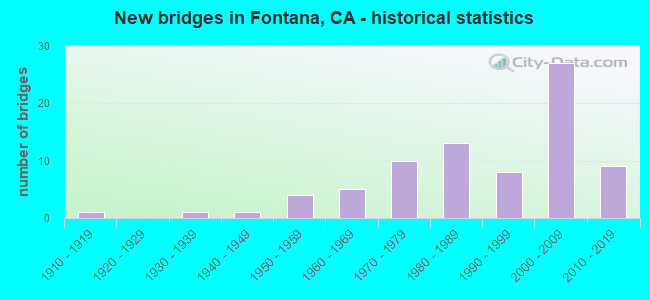
- New bridges - historical statistics
- 11910-1919
- 11930-1939
- 11940-1949
- 41950-1959
- 51960-1969
- 101970-1979
- 131980-1989
- 81990-1999
- 272000-2009
- 92010-2019
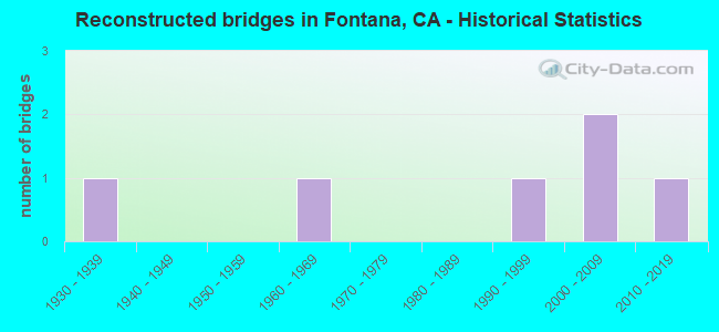
- Reconstructed bridges - Historical Statistics
- 11930-1939
- 01940-1949
- 01950-1959
- 11960-1969
- 01970-1979
- 01980-1989
- 11990-1999
- 22000-2009
- 12010-2019
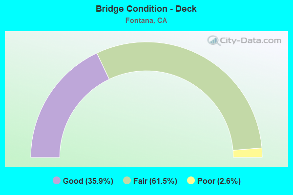
- Bridge Condition - Deck
- 35.9%Good
- 61.5%Fair
- 2.6%Poor
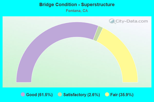
- Bridge Condition - Superstructure
- 61.5%Good
- 2.6%Satisfactory
- 35.9%Fair
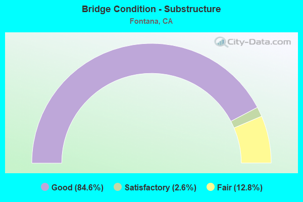
- Bridge Condition - Substructure
- 84.6%Good
- 2.6%Satisfactory
- 12.8%Fair
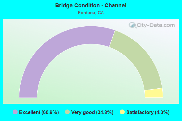
- Bridge Condition - Channel
- 60.9%Excellent
- 34.8%Very good
- 4.3%Satisfactory
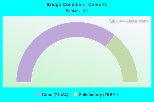
- Bridge Condition - Culverts
- 71.4%Good
- 28.6%Satisfactory
Find on map >> Show street view
Structure Number: 54C0619, Location: 0.3 MI SW HERITAGE CIRC (Lat: 34.118269, Lng: -117.508228), Route carried "on" structure: City street , Year Built: 1988, Status: Open, Structure Length: 1.89m (6.20ft), Average Daily Traffic: 1,934 (year 2015), Truck Traffic: 2%, Average Future Daily Traffic: 2,652 (year 2040), Features Intersected: E ETIWANDA CREEK CHANNEL, Facility Carried by Structure: W LIBERTY PARKWY N
Minimum Vertical Clearance: 30+ m (98+ ft), Kilometerpoint: 0.000, Lanes on structure: 4, Owner: City or Municipal Highway Agency, Approaching Roadway Width: 15.8m (51.8ft), Skew: 30 degrees, Material/Design: Concrete, Design/Construction: Culvert, Number Of Spans In Main Unit: 4, Length of Maximum Span: 4.3m (14.1ft), Curb or Sidewalk Widths: Left: 0.2m (0.7ft), Right: 2.4m (7.9ft), Curb-To-Curb Width: 15.8m (51.8ft), Out-to-Out Width: 31.7m (104.0ft)
Condition: Channel: Excellent, Culverts: Good, Operating Rating: 54.1 metric tons, Method Used To Determine Operating Rating: Field evaluation and documented engineering judgment, Inventory Rating: 32.4 metric tons, Method Used To Determine Inventory Rating: Field evaluation and documented engineering judgment, Structural Evaluation: Better than present minimum criteria, Deck Geometry: Meets minimum limits, Waterway Adequacy: Superior to present desirable criteria, Approach Roadway Alignment: Equal to present minimum criteria, Designated Inspection Frequency: Every 48 months, Inspection Date: June 2020
Find on map >> Show street view
Structure Number: 54C062, Location: 0.45 MI E OF ROUTE 1-15 (Lat: 34.121231, Lng: -117.506403), Route carried "on" structure: City street , Year Built: 1988, Status: Open, Structure Length: 1.74m (5.71ft), Average Daily Traffic: 29,500 (year 2015), Truck Traffic: 2%, Average Future Daily Traffic: 36,726 (year 2040), Features Intersected: E ETIWANDA CREEK CHANNEL, Facility Carried by Structure: BASELINE RD
Minimum Vertical Clearance: 30+ m (98+ ft), Kilometerpoint: 0.000, Lanes on structure: 6, Base Highway Network: Yes, Owner: City or Municipal Highway Agency, Approaching Roadway Width: 30.5m (100.1ft), Skew: 32 degrees, Material/Design: Concrete, Design/Construction: Culvert, Number Of Spans In Main Unit: 4, Length of Maximum Span: 3.7m (12.1ft), Curb or Sidewalk Widths: Left: 1.5m (4.9ft), Right: 1.5m (4.9ft), Curb-To-Curb Width: 30.5m (100.1ft), Out-to-Out Width: 43.9m (144.0ft)
Condition: Channel: Very good, Culverts: Good, Operating Rating: 54.1 metric tons, Method Used To Determine Operating Rating: Field evaluation and documented engineering judgment, Inventory Rating: 32.4 metric tons, Method Used To Determine Inventory Rating: Field evaluation and documented engineering judgment, Structural Evaluation: Better than present minimum criteria, Deck Geometry: Superior to present desirable criteria, Waterway Adequacy: Equal to present desirable criteria, Approach Roadway Alignment: Equal to present desirable criteria, Designated Inspection Frequency: Every 48 months, Inspection Date: June 2020
Find on map >> Show street view
Structure Number: 54C0621, Location: 75' W OF HERITAGE CIRCLE (Lat: 34.123075, Lng: -117.505217), Route carried "on" structure: City street , Year Built: 1988, Status: Open, Structure Length: 1.52m (4.99ft), Average Daily Traffic: 650 (year 2011), Truck Traffic: 2%, Average Future Daily Traffic: 765 (year 2037), Features Intersected: E ETIWANDA CREEK CHANNEL, Facility Carried by Structure: DEL NORTE ST
Minimum Vertical Clearance: 30+ m (98+ ft), Kilometerpoint: 0.000, Lanes on structure: 2, Owner: City or Municipal Highway Agency, Approaching Roadway Width: 11.0m (36.1ft), Skew: 1 degrees, Material/Design: Concrete, Design/Construction: Culvert, Number Of Spans In Main Unit: 4, Length of Maximum Span: 3.7m (12.1ft), Curb or Sidewalk Widths: Left: 1.2m (3.9ft), Right: 1.2m (3.9ft), Curb-To-Curb Width: 11.0m (36.1ft), Out-to-Out Width: 18.3m (60.0ft)
Condition: Channel: Excellent, Culverts: Satisfactory, Operating Rating: 54.1 metric tons, Method Used To Determine Operating Rating: Field evaluation and documented engineering judgment, Inventory Rating: 32.4 metric tons, Method Used To Determine Inventory Rating: Field evaluation and documented engineering judgment, Structural Evaluation: Equal to present minimum criteria, Deck Geometry: Better than present minimum criteria, Waterway Adequacy: Superior to present desirable criteria, Approach Roadway Alignment: Equal to present minimum criteria, Designated Inspection Frequency: Every 48 months, Inspection Date: September 2018, Deck Structure Type: Concrete Cast-file-Place
Find on map >> Show street view
Structure Number: 54C0622, Location: 0.6 MI E ETIWANDA AVE (Lat: 34.062564, Lng: -117.515153), Route carried "on" structure: City street , Year Built: 1989, Status: Open, Structure Length: 1.86m (6.10ft), Average Daily Traffic: 17,000 (year 2011), Truck Traffic: 10%, Average Future Daily Traffic: 22,540 (year 2037), Features Intersected: SAN SEVAINE CREEK, Facility Carried by Structure: SLOVER AVE
Minimum Vertical Clearance: 30+ m (98+ ft), Kilometerpoint: 0.000, Lanes on structure: 5, Owner: City or Municipal Highway Agency, Approaching Roadway Width: 21.9m (71.9ft), Material/Design: Concrete, Design/Construction: Culvert, Number Of Spans In Main Unit: 4, Length of Maximum Span: 4.3m (14.1ft), Curb or Sidewalk Widths: Left: 0.2m (0.7ft), Right: 1.8m (5.9ft), Curb-To-Curb Width: 21.9m (71.9ft), Out-to-Out Width: 30.5m (100.1ft)
Condition: Channel: Excellent, Culverts: Satisfactory, Operating Rating: 54.1 metric tons, Method Used To Determine Operating Rating: Field evaluation and documented engineering judgment, Inventory Rating: 32.4 metric tons, Method Used To Determine Inventory Rating: Field evaluation and documented engineering judgment, Structural Evaluation: Equal to present minimum criteria, Deck Geometry: Somewhat better than minimum adequacy, Waterway Adequacy: Superior to present desirable criteria, Approach Roadway Alignment: Equal to present desirable criteria, Designated Inspection Frequency: Every 48 months, Inspection Date: September 2018
Find on map >> Show street view
Structure Number: 54C0623, Location: 0.5 MI E MULBERRY (Lat: 34.033472, Lng: -117.499667), Route carried "on" structure: City street , Year Built: 1985, Status: Open, Structure Length: 0.79m (2.59ft), Average Daily Traffic: 100 (year 2015), Truck Traffic: 1%, Average Future Daily Traffic: 125 (year 2040), Features Intersected: DECLEZ CHANNEL, Facility Carried by Structure: PHILADELPHIA ST
Minimum Vertical Clearance: 30+ m (98+ ft), Kilometerpoint: 0.000, Lanes on structure: 2, Owner: City or Municipal Highway Agency, Approaching Roadway Width: 11.0m (36.1ft), Material/Design: Concrete, Design/Construction: Culvert, Number Of Spans In Main Unit: 1, Length of Maximum Span: 7.3m (24.0ft), Curb or Sidewalk Widths: Left: 1.9m (6.2ft), Right: 1.9m (6.2ft), Curb-To-Curb Width: 10.8m (35.4ft), Out-to-Out Width: 14.9m (48.9ft)
Condition: Channel: Excellent, Culverts: Good, Operating Rating: 54.1 metric tons, Method Used To Determine Operating Rating: Field evaluation and documented engineering judgment, Inventory Rating: 32.4 metric tons, Method Used To Determine Inventory Rating: Field evaluation and documented engineering judgment, Structural Evaluation: Better than present minimum criteria, Deck Geometry: Superior to present desirable criteria, Waterway Adequacy: Superior to present desirable criteria, Approach Roadway Alignment: Equal to present desirable criteria, Designated Inspection Frequency: Every 48 months, Inspection Date: June 2020, Deck Structure Type: Concrete Cast-file-Place, Wearing Surface/Protective System: Wearing Surface: Bituminous
Find on map >> Show street view
Structure Number: 54C0624, Location: 0.6 MI SW LIVE OAK AVE (Lat: 34.037928, Lng: -117.494839), Route carried "on" structure: City street , Year Built: 1985, Status: Open, Structure Length: 1.55m (5.09ft), Average Daily Traffic: 14,000 (year 2011), Truck Traffic: 2%, Average Future Daily Traffic: 18,895 (year 2037), Features Intersected: DECLEZ CHANNEL, Facility Carried by Structure: CHERRY AVE
Minimum Vertical Clearance: 30+ m (98+ ft), Kilometerpoint: 0.000, Lanes on structure: 4, Owner: City or Municipal Highway Agency, Approaching Roadway Width: 15.8m (51.8ft), Skew: 1 degrees, Material/Design: Prestressed concrete, Design/Construction: Slab, Number Of Spans In Main Unit: 1, Length of Maximum Span: 14.6m (47.9ft), Curb or Sidewalk Widths: Left: 1.8m (5.9ft), Right: 2.4m (7.9ft), Curb-To-Curb Width: 15.8m (51.8ft), Out-to-Out Width: 21.2m (69.6ft)
Condition: Deck: Good, Superstructure: Good, Substructure: Good, Channel: Excellent, Operating Rating: 54.1 metric tons, Method Used To Determine Operating Rating: Field evaluation and documented engineering judgment, Inventory Rating: 32.4 metric tons, Method Used To Determine Inventory Rating: Field evaluation and documented engineering judgment, Structural Evaluation: Better than present minimum criteria, Deck Geometry: Meets minimum limits, Waterway Adequacy: Superior to present desirable criteria, Approach Roadway Alignment: Equal to present desirable criteria, Designated Inspection Frequency: Every 48 months, Inspection Date: June 2020, Deck Structure Type: Concrete Cast-file-Place, Wearing Surface/Protective System: Wearing Surface: Integral Concrete
Find on map >> Show street view
Structure Number: 54C0625, Location: 1.55 MI S OF ROUTE 1-10 (Lat: 34.043769, Lng: -117.488161), Route carried "on" structure: City street , Year Built: 1985, Status: Open, Structure Length: 1.55m (5.09ft), Average Daily Traffic: 12,000 (year 2011), Truck Traffic: 1%, Average Future Daily Traffic: 15,303 (year 2037), Features Intersected: DECLEZ CHANNEL, Facility Carried by Structure: CHERRY AVE
Minimum Vertical Clearance: 30+ m (98+ ft), Kilometerpoint: 0.000, Lanes on structure: 4, Owner: City or Municipal Highway Agency, Approaching Roadway Width: 15.8m (51.8ft), Skew: 1 degrees, Material/Design: Prestressed concrete, Design/Construction: Slab, Number Of Spans In Main Unit: 1, Length of Maximum Span: 14.6m (47.9ft), Curb or Sidewalk Widths: Left: 2.4m (7.9ft), Right: 1.8m (5.9ft), Curb-To-Curb Width: 15.8m (51.8ft), Out-to-Out Width: 21.2m (69.6ft)
Condition: Deck: Good, Superstructure: Good, Substructure: Good, Channel: Excellent, Operating Rating: 54.1 metric tons, Method Used To Determine Operating Rating: Field evaluation and documented engineering judgment, Inventory Rating: 32.4 metric tons, Method Used To Determine Inventory Rating: Field evaluation and documented engineering judgment, Structural Evaluation: Better than present minimum criteria, Deck Geometry: Meets minimum limits, Waterway Adequacy: Superior to present desirable criteria, Approach Roadway Alignment: Equal to present desirable criteria, Length Of Structure Improvement: 1.55m (5.09ft), Designated Inspection Frequency: Every 48 months, Inspection Date: June 2020, Bridge Improvement Cost: $329,000, Roadway Improvement Cost: $65,000, Total Project Cost: $552,000 ( Estimate for 2018), Deck Structure Type: Concrete Cast-file-Place
Find on map >> Show street view
Structure Number: 54C0626, Location: 0.2 MI S JURUPA AVE (Lat: 34.045319, Lng: -117.481022), Route carried "on" structure: City street , Year Built: 1989, Status: Open, Structure Length: 1.46m (4.79ft), Average Daily Traffic: 8,500 (year 2011), Truck Traffic: 2%, Average Future Daily Traffic: 10,712 (year 2037), Features Intersected: DECLEZ CHANNEL, Facility Carried by Structure: LIVE OAK AVE
Minimum Vertical Clearance: 30+ m (98+ ft), Kilometerpoint: 0.000, Lanes on structure: 2, Owner: City or Municipal Highway Agency, Approaching Roadway Width: 11.9m (39.0ft), Skew: 2 degrees, Material/Design: Concrete, Design/Construction: Culvert, Number Of Spans In Main Unit: 5, Length of Maximum Span: 2.4m (7.9ft), Curb or Sidewalk Widths: Left: 1.8m (5.9ft), Right: 1.4m (4.6ft), Curb-To-Curb Width: 11.9m (39.0ft), Out-to-Out Width: 19.2m (63.0ft)
Condition: Channel: Excellent, Culverts: Good, Operating Rating: 54.1 metric tons, Method Used To Determine Operating Rating: Field evaluation and documented engineering judgment, Inventory Rating: 32.4 metric tons, Method Used To Determine Inventory Rating: Field evaluation and documented engineering judgment, Structural Evaluation: Better than present minimum criteria, Deck Geometry: Somewhat better than minimum adequacy, Waterway Adequacy: Superior to present desirable criteria, Approach Roadway Alignment: Equal to present desirable criteria, Designated Inspection Frequency: Every 48 months, Inspection Date: September 2018
Find on map >> Show street view
Structure Number: 54C0628, Location: 0.4 MI S JURUPA AVE (Lat: 34.042867, Lng: -117.471089), Route carried "on" structure: City street , Year Built: 1990, Status: Open, Structure Length: 1.64m (5.38ft), Average Daily Traffic: 4,854 (year 2011), Truck Traffic: 1%, Average Future Daily Traffic: 5,653 (year 2042), Features Intersected: DECLEZ CHANNEL, Facility Carried by Structure: BEECH AVE
Minimum Vertical Clearance: 30+ m (98+ ft), Kilometerpoint: 0.000, Lanes on structure: 5, Owner: City or Municipal Highway Agency, Approaching Roadway Width: 19.7m (64.6ft), Skew: 34 degrees, Material/Design: Concrete, Design/Construction: Culvert, Number Of Spans In Main Unit: 4, Length of Maximum Span: 2.4m (7.9ft), Curb or Sidewalk Widths: Left: 1.7m (5.6ft), Right: 1.4m (4.6ft), Curb-To-Curb Width: 19.7m (64.6ft), Out-to-Out Width: 24.1m (79.1ft)
Condition: Channel: Excellent, Culverts: Good, Operating Rating: 54.1 metric tons, Method Used To Determine Operating Rating: Field evaluation and documented engineering judgment, Inventory Rating: 32.4 metric tons, Method Used To Determine Inventory Rating: Field evaluation and documented engineering judgment, Structural Evaluation: Better than present minimum criteria, Deck Geometry: Meets minimum limits, Waterway Adequacy: Superior to present desirable criteria, Approach Roadway Alignment: Equal to present desirable criteria, Designated Inspection Frequency: Every 48 months, Inspection Date: June 2020, Deck Structure Type: Concrete Cast-file-Place, Wearing Surface/Protective System: Wearing Surface: Bituminous
Find on map >> Show street view
Structure Number: 54C0629, Location: 0.1 MI E OF BEECH AVE (Lat: 34.043936, Lng: -117.470075), Route carried "on" structure: City street , Year Built: 2003, Status: Open, Structure Length: 1.08m (3.54ft), Average Daily Traffic: 600 (year 2011), Truck Traffic: 1%, Average Future Daily Traffic: 830 (year 2042), Features Intersected: DECLEZ CHANNEL, Facility Carried by Structure: CHAPS LANE
Minimum Vertical Clearance: 30+ m (98+ ft), Kilometerpoint: 0.000, Lanes on structure: 2, Owner: City or Municipal Highway Agency, Approaching Roadway Width: 10.8m (35.4ft), Material/Design: Concrete, Design/Construction: Culvert, Number Of Spans In Main Unit: 4, Length of Maximum Span: 2.4m (7.9ft), Curb or Sidewalk Widths: Left: 2.1m (6.9ft), Right: 2.0m (6.6ft), Curb-To-Curb Width: 10.8m (35.4ft), Out-to-Out Width: 15.5m (50.9ft)
Condition: Channel: Excellent, Culverts: Good, Operating Rating: 54.1 metric tons, Method Used To Determine Operating Rating: Field evaluation and documented engineering judgment, Inventory Rating: 32.4 metric tons, Method Used To Determine Inventory Rating: Field evaluation and documented engineering judgment, Structural Evaluation: Better than present minimum criteria, Deck Geometry: Equal to present minimum criteria, Waterway Adequacy: Equal to present desirable criteria, Approach Roadway Alignment: Equal to present desirable criteria, Designated Inspection Frequency: Every 48 months, Inspection Date: June 2020, Deck Structure Type: Concrete Cast-file-Place, Wearing Surface/Protective System: Wearing Surface: Bituminous
Find on map >> Show street view
Structure Number: 54C0632, Location: 0.1 MI S JURUPA AVE (Lat: 34.046794, Lng: -117.453694), Route carried "on" structure: City street , Year Built: 1990, Status: Open, Structure Length: 1.07m (3.51ft), Average Daily Traffic: 5,500 (year 2011), Truck Traffic: 2%, Average Future Daily Traffic: 7,243 (year 2037), Features Intersected: DECLEZ CHANNEL, Facility Carried by Structure: CITRUS AVE
Minimum Vertical Clearance: 30+ m (98+ ft), Kilometerpoint: 0.000, Lanes on structure: 4, Owner: City or Municipal Highway Agency, Approaching Roadway Width: 17.1m (56.1ft), Skew: 20 degrees, Material/Design: Concrete, Design/Construction: Culvert, Number Of Spans In Main Unit: 4, Length of Maximum Span: 2.4m (7.9ft), Curb or Sidewalk Widths: Left: 1.5m (4.9ft), Right: 1.7m (5.6ft), Curb-To-Curb Width: 17.1m (56.1ft), Out-to-Out Width: 24.5m (80.4ft)
Condition: Channel: Excellent, Culverts: Satisfactory, Operating Rating: 54.1 metric tons, Method Used To Determine Operating Rating: Field evaluation and documented engineering judgment, Inventory Rating: 32.4 metric tons, Method Used To Determine Inventory Rating: Field evaluation and documented engineering judgment, Structural Evaluation: Equal to present minimum criteria, Deck Geometry: Somewhat better than minimum adequacy, Waterway Adequacy: Superior to present desirable criteria, Approach Roadway Alignment: Equal to present desirable criteria, Designated Inspection Frequency: Every 48 months, Inspection Date: September 2018
Find on map >> Show street view
Structure Number: 54C0682, Location: 0.1 MI E COMMERCE DR (Lat: 34.070761, Lng: -117.515114), Route carried "on" structure: County highway , Year Built: 2002, Status: Open, Structure Length: 5.33m (17.49ft), Average Daily Traffic: 20,930 (year 2015), Truck Traffic: 2%, Average Future Daily Traffic: 26,967 (year 2040), Design Load: HS 20, Features Intersected: SAN SEVAINE CHANNEL, Facility Carried by Structure: VALLEY BLVD.
Minimum Vertical Clearance: 30+ m (98+ ft), Kilometerpoint: 0.000, Lanes on structure: 8, Owner: County Highway Agency, Approaching Roadway Width: 36.9m (121.1ft), Material/Design: Concrete continuous, Design/Construction: Box Beam or Girders - Multiple, Number Of Spans In Main Unit: 2, Length of Maximum Span: 26.7m (87.6ft), Curb or Sidewalk Widths: Left: 1.5m (4.9ft), Right: 1.5m (4.9ft), Curb-To-Curb Width: 36.9m (121.1ft), Out-to-Out Width: 40.5m (132.9ft)
Condition: Deck: Fair, Superstructure: Good, Substructure: Good, Channel: Excellent, Operating Rating: 54.1 metric tons, Method Used To Determine Operating Rating: Assigned rating based on Load Factor Design (LFD) reported in metric tons, Inventory Rating: 32.4 metric tons, Method Used To Determine Inventory Rating: Assigned rating based on Load Factor Design (LFD) reported in metric tons, Structural Evaluation: Better than present minimum criteria, Deck Geometry: Superior to present desirable criteria, Underclear: Equal to present minimum criteria, Waterway Adequacy: Equal to present desirable criteria, Approach Roadway Alignment: Equal to present desirable criteria, Designated Inspection Frequency: Every 24 months, Inspection Date: June 2020, Deck Structure Type: Concrete Cast-file-Place
Find on map >> Show street view
Structure Number: 54C0721M, Location: JUST E/O HOSPITAL PKWY (Lat: 34.106886, Lng: -117.636572), Route carried "on" structure: City street , Year Built: 1914, Year Reconstructed: 1937, Status: Open, Structure Length: 0.70m (2.30ft), Average Daily Traffic: 31,500 (year 2015), Truck Traffic: 2%, Average Future Daily Traffic: 35,000 (year 2040), Features Intersected: CUCAMONGA OVERFLOW, Facility Carried by Structure: FOOTHILL BLVD
Minimum Vertical Clearance: 30+ m (98+ ft), Kilometerpoint: 0.000, Lanes on structure: 5, Base Highway Network: Yes, Owner: City or Municipal Highway Agency, Approaching Roadway Width: 21.9m (71.9ft), Skew: 20 degrees, Material/Design: Concrete continuous, Design/Construction: Slab, Number Of Spans In Main Unit: 2, Length of Maximum Span: 3.4m (11.2ft), Curb-To-Curb Width: 22.9m (75.1ft), Out-to-Out Width: 23.7m (77.8ft)
Condition: Deck: Good, Superstructure: Good, Substructure: Fair, Channel: Very good, Operating Rating: 26.9 metric tons, Method Used To Determine Operating Rating: Field evaluation and documented engineering judgment, Inventory Rating: 16.2 metric tons, Method Used To Determine Inventory Rating: Field evaluation and documented engineering judgment, Structural Evaluation: Meets minimum limits, Deck Geometry: Equal to present minimum criteria, Waterway Adequacy: Equal to present desirable criteria, Approach Roadway Alignment: Equal to present desirable criteria, Designated Inspection Frequency: Every 24 months, Inspection Date: May 2021, Deck Structure Type: Concrete Cast-file-Place, Wearing Surface/Protective System: Wearing Surface: Bituminous
Find on map >> Show street view
Structure Number: 54 0030L, Location: 08-SBD-010-11.50 (Lat: 34.067769, Lng: -117.517056), Route carried "under" structure: Ramp Interstate 10, Year Built: 1947, Structure Length: 0. m, Average Daily Traffic: 15,000 (year 2019), Truck Traffic: 14%, Features Intersected: E10-VALLEY BLVD OFF-RAMP
Minimum Vertical Clearance: 5.23m (17.16ft), Kilometerpoint: 11.500, Lanes on structure: 4, Lanes under structure: 1, Material/Design: Steel continuous, Design/Construction: Stringer/Multi-beam, Length of Maximum Span: 15.5m (50.9ft)
Find on map >> Show street view
Structure Number: 54 0030R, Location: 08-SBD-010-11.50 (Lat: 34.067458, Lng: -117.517828), Route carried "under" structure: Ramp Interstate 10, Year Built: 1966, Structure Length: 0. m, Average Daily Traffic: 15,000 (year 2019), Truck Traffic: 14%, Features Intersected: E10-VALLEY BLVD OFF-RAMP
Minimum Vertical Clearance: 5.16m (16.93ft), Kilometerpoint: 11.500, Lanes on structure: 4, Lanes under structure: 1, Material/Design: Steel continuous, Design/Construction: Stringer/Multi-beam, Length of Maximum Span: 29.0m (95.1ft)
Find on map >> Show street view
Structure Number: 54 065, Location: 08-SBD-210-14.93-FNA (Lat: 34.136733, Lng: -117.436250), Route carried "under" structure: State highway 210, Year Built: 2001, Structure Length: 0. m, Average Daily Traffic: 120,000 (year 2019), Truck Traffic: 3%, Features Intersected: STATE ROUTE 210, Facility Carried by Structure: SIERRA AVENUE
Minimum Vertical Clearance: 5.31m (17.42ft), Kilometerpoint: 14.930, Lanes on structure: 7, Lanes under structure: 10, Material/Design: Prestressed concrete continuous, Design/Construction: Box Beam or Girders - Multiple, Length of Maximum Span: 42.5m (139.4ft)
Find on map >> Show street view
Structure Number: 54 0672, Location: 08-SBD-210-13.93-FNA (Lat: 34.136725, Lng: -117.453711), Route carried "under" structure: State highway 210, Year Built: 2001, Structure Length: 0. m, Average Daily Traffic: 120,000 (year 2019), Truck Traffic: 3%, Features Intersected: STATE ROUTE 210, Facility Carried by Structure: CITRUS AVENUE
Minimum Vertical Clearance: 5.16m (16.93ft), Kilometerpoint: 13.930, Lanes on structure: 6, Lanes under structure: 8, Material/Design: Prestressed concrete continuous, Design/Construction: Box Beam or Girders - Multiple, Length of Maximum Span: 39.0m (128.0ft)
Find on map >> Show street view
Structure Number: 54 0682L, Location: 08-SBD-210-11.91-FNA (Lat: 34.136436, Lng: -117.488661), Route carried "under" structure: City street , Year Built: 2000, Structure Length: 0. m, Average Daily Traffic: 5,500 (year 2014), Truck Traffic: 5%, Features Intersected: CHERRY AVENUE, Facility Carried by Structure: STATE ROUTE 210 WB
Minimum Vertical Clearance: 4.52m (14.83ft), Kilometerpoint: 0.000, Lanes on structure: 4, Lanes under structure: 6, Material/Design: Prestressed concrete, Design/Construction: Box Beam or Girders - Multiple, Length of Maximum Span: 42.2m (138.5ft)
Find on map >> Show street view
Structure Number: 54 0682R, Location: 08-SBD-210-11.91-FNA (Lat: 34.136142, Lng: -117.488656), Route carried "under" structure: City street , Year Built: 2000, Structure Length: 0. m, Average Daily Traffic: 5,500 (year 2014), Truck Traffic: 5%, Features Intersected: CHERRY AVENUE, Facility Carried by Structure: STATE ROUTE 210 EB
Minimum Vertical Clearance: 4.93m (16.17ft), Kilometerpoint: 0.000, Lanes on structure: 4, Lanes under structure: 6, Material/Design: Prestressed concrete, Design/Construction: Box Beam or Girders - Multiple, Length of Maximum Span: 42.2m (138.5ft)
Find on map >> Show street view
Structure Number: 54 0959F, Location: 08-SBD-210-11.75-FNA (Lat: 34.138314, Lng: -117.491614), Route carried "under" structure: Ramp State highway 210, Year Built: 2001, Structure Length: 0. m, Average Daily Traffic: 3,001 (year 2021), Truck Traffic: 3%, Features Intersected: E210-N15 CONNECTOR RAMP
Minimum Vertical Clearance: 7.08m (23.23ft), Kilometerpoint: 11.900, Lanes on structure: 2, Lanes under structure: 2, Material/Design: Prestressed concrete, Design/Construction: Box Beam or Girders - Multiple, Length of Maximum Span: 36.0m (118.1ft)
Find on map >> Show street view
Structure Number: 54 0962L, Location: 08-SBD-210-11.63-FNA (Lat: 34.136422, Lng: -117.493431), Route carried "under" structure: Ramp State highway 210, Year Built: 1999, Structure Length: 0. m, Average Daily Traffic: 3,001 (year 2021), Truck Traffic: 5%, Features Intersected: E210-N15 CONNECTOR RAMP
Minimum Vertical Clearance: 5.36m (17.59ft), Kilometerpoint: 11.630, Lanes on structure: 5, Lanes under structure: 2, Material/Design: Prestressed concrete, Design/Construction: Box Beam or Girders - Multiple, Length of Maximum Span: 48.6m (159.4ft)
Find on map >> Show street view
Structure Number: 54 0962R, Location: 08-SBD-210-11.63-FNA (Lat: 34.136106, Lng: -117.493875), Route carried "under" structure: Ramp State highway 210, Year Built: 1999, Structure Length: 0. m, Average Daily Traffic: 3,001 (year 2021), Truck Traffic: 3%, Features Intersected: E210-N15 CONNECTOR RAMP
Minimum Vertical Clearance: 6.10m (20.01ft), Kilometerpoint: 11.630, Lanes on structure: 5, Lanes under structure: 2, Material/Design: Prestressed concrete, Design/Construction: Box Beam or Girders - Multiple, Length of Maximum Span: 52.2m (171.3ft)
Find on map >> Show street view
Structure Number: 54 098, Location: 08-SBD-015-11.03-FNA (Lat: 34.164933, Lng: -117.462097), Route carried "under" structure: Interstate 15, Year Built: 1976, Structure Length: 0. m, Average Daily Traffic: 127,000 (year 2017), Truck Traffic: 11%, Features Intersected: INTERSTATE 15, Facility Carried by Structure: DUNCAN CANYON ROAD
Minimum Vertical Clearance: 5.21m (17.09ft), Kilometerpoint: 11.030, Lanes on structure: 4, Lanes under structure: 8, Material/Design: Prestressed concrete continuous, Design/Construction: Box Beam or Girders - Multiple, Length of Maximum Span: 59.2m (194.2ft)
Find on map >> Show street view
Structure Number: 54 0981L, Location: 08-SBD-015-12.84-FNA (Lat: 34.181572, Lng: -117.437006), Route carried "under" structure: County highway R052, Year Built: 1976, Structure Length: 0. m, Average Daily Traffic: 5,000 (year 2020), Truck Traffic: 10%, Features Intersected: SIERRA AVENUE, Facility Carried by Structure: INTERSTATE 15 SB
Minimum Vertical Clearance: 4.88m (16.01ft), Kilometerpoint: 0.000, Lanes on structure: 4, Lanes under structure: 5, Material/Design: Prestressed concrete, Design/Construction: Box Beam or Girders - Multiple, Length of Maximum Span: 44.5m (146.0ft)
Find on map >> Show street view
Structure Number: 54 0981R, Location: 08-SBD-015-12.84-FNA (Lat: 34.181225, Lng: -117.436842), Route carried "under" structure: County highway R052, Year Built: 1976, Structure Length: 0. m, Average Daily Traffic: 5,000 (year 2020), Truck Traffic: 10%, Features Intersected: SIERRA AVENUE, Facility Carried by Structure: INTERSTATE 15 NB
Minimum Vertical Clearance: 6.27m (20.57ft), Kilometerpoint: 0.000, Lanes on structure: 4, Lanes under structure: 4, Material/Design: Prestressed concrete, Design/Construction: Box Beam or Girders - Multiple, Length of Maximum Span: 48.8m (160.1ft)
Find on map >> Show street view
Structure Number: 54 1136F, Location: 08-SBD-210-11.91-FNA (Lat: 34.138008, Lng: -117.488736), Route carried "under" structure: City street , Year Built: 2000, Structure Length: 0. m, Average Daily Traffic: 5,500 (year 2014), Truck Traffic: 5%, Features Intersected: CHERRY AVENUE, Facility Carried by Structure: W210-N15 CONNECTOR
Minimum Vertical Clearance: 4.60m (15.09ft), Kilometerpoint: 0.000, Lanes on structure: 2, Lanes under structure: 4, Material/Design: Prestressed concrete, Design/Construction: Box Beam or Girders - Multiple, Length of Maximum Span: 53.0m (173.9ft)
Find on map >> Show street view
Structure Number: 54 1137F, Location: 08-SBD-210-11.91-FNA (Lat: 34.137622, Lng: -117.488756), Route carried "under" structure: City street , Year Built: 2000, Structure Length: 0. m, Average Daily Traffic: 5,500 (year 2014), Truck Traffic: 5%, Features Intersected: CHERRY AVENUE, Facility Carried by Structure: W210-S15 CONNECTOR
Minimum Vertical Clearance: 5.72m (18.77ft), Kilometerpoint: 0.000, Lanes on structure: 2, Lanes under structure: 4, Material/Design: Prestressed concrete, Design/Construction: Box Beam or Girders - Multiple, Length of Maximum Span: 50.1m (164.4ft)
Find on map >> Show street view
Structure Number: 54 1138H, Location: 08-SBD-015-8.50-FNA (Lat: 34.135075, Lng: -117.488733), Route carried "under" structure: City street , Year Built: 2001, Structure Length: 0. m, Average Daily Traffic: 9,800 (year 2019), Truck Traffic: 2%, Features Intersected: CHERRY AVEUNE, Facility Carried by Structure: NS15-E210 CONNECT
Minimum Vertical Clearance: 4.62m (15.16ft), Kilometerpoint: 0.000, Lanes on structure: 3, Lanes under structure: 5, Material/Design: Prestressed concrete, Design/Construction: Box Beam or Girders - Single/Spread, Length of Maximum Span: 44.2m (145.0ft)
Find on map >> Show street view
Structure Number: 54 1139, Location: 08-SBD-210-12.41-FNA (Lat: 34.136092, Lng: -117.479947), Route carried "under" structure: City street , Year Built: 2000, Structure Length: 0. m, Average Daily Traffic: 200 (year 2013), Truck Traffic: 2%, Features Intersected: SAN SEVAINE ROAD, Facility Carried by Structure: STATE ROUTE 210
Minimum Vertical Clearance: 4.67m (15.32ft), Kilometerpoint: 0.000, Lanes on structure: 13, Lanes under structure: 2, Material/Design: Prestressed concrete, Design/Construction: Box Beam or Girders - Multiple, Length of Maximum Span: 37.7m (123.7ft)
Find on map >> Show street view
Structure Number: 54 1140L, Location: 08-SBD-210-12.91-FNA (Lat: 34.136544, Lng: -117.471239), Route carried "under" structure: City street , Year Built: 2000, Structure Length: 0. m, Average Daily Traffic: 5,001 (year 2021), Truck Traffic: 2%, Features Intersected: BEECH AVENUE, Facility Carried by Structure: STATE ROUTE 210 WB
Minimum Vertical Clearance: 5.33m (17.49ft), Kilometerpoint: 0.000, Lanes on structure: 5, Lanes under structure: 5, Material/Design: Prestressed concrete, Design/Construction: Box Beam or Girders - Multiple, Length of Maximum Span: 40.4m (132.5ft)
Find on map >> Show street view
Structure Number: 54 1140R, Location: 08-SBD-210-12.91-FNA (Lat: 34.136083, Lng: -117.471203), Route carried "under" structure: City street , Year Built: 2000, Structure Length: 0. m, Average Daily Traffic: 5,001 (year 2021), Truck Traffic: 2%, Features Intersected: BEECH AVENUE, Facility Carried by Structure: STATE ROUTE 210 EB
Minimum Vertical Clearance: 6.76m (22.18ft), Kilometerpoint: 0.000, Lanes on structure: 5, Lanes under structure: 5, Material/Design: Prestressed concrete, Design/Construction: Box Beam or Girders - Multiple, Length of Maximum Span: 40.4m (132.5ft)
Find on map >> Show street view
Structure Number: 54 1169, Location: 08-SBD-010-16.22-FNA (Lat: 34.067706, Lng: -117.435836), Route carried "under" structure: Interstate 10, Year Built: 2002, Structure Length: 0. m, Average Daily Traffic: 208,000 (year 2018), Truck Traffic: 10%, Features Intersected: INTERSTATE 10, Facility Carried by Structure: SIERRA AVENUE
Minimum Vertical Clearance: 5.31m (17.42ft), Kilometerpoint: 16.220, Lanes on structure: 6, Lanes under structure: 8, Material/Design: Prestressed concrete continuous, Design/Construction: Box Beam or Girders - Multiple, Length of Maximum Span: 30.0m (98.4ft)
Find on map >> Show street view
Structure Number: 54 1214K, Location: 08-SBD-010-11.35 (Lat: 34.068111, Lng: -117.520403), Route carried "under" structure: Ramp Interstate 10, Year Built: 2004, Structure Length: 0. m, Average Daily Traffic: 9,000 (year 2016), Truck Traffic: 10%, Features Intersected: W10-ETIWANDA AVE OFFRAMP
Minimum Vertical Clearance: 5.18m (16.99ft), Kilometerpoint: 11.350, Lanes on structure: 1, Lanes under structure: 1, Material/Design: Prestressed concrete continuous, Design/Construction: Box Beam or Girders - Multiple, Length of Maximum Span: 31.6m (103.7ft)
Find on map >> Show street view
Structure Number: 54 128, Location: 08-SBD-010-15.73-FNA (Lat: 34.067572, Lng: -117.444475), Route carried "under" structure: Interstate 10, Year Built: 2010, Structure Length: 0. m, Average Daily Traffic: 208,000 (year 2018), Truck Traffic: 10%, Features Intersected: INTERSTATE 10, Facility Carried by Structure: CYPRESS AVENUE
Minimum Vertical Clearance: 6.81m (22.34ft), Kilometerpoint: 15.730, Lanes on structure: 4, Lanes under structure: 10, Material/Design: Concrete continuous, Design/Construction: Box Beam or Girders - Multiple, Length of Maximum Span: 38.6m (126.6ft)
Find on map >> Show street view
Structure Number: 54 1292, Location: 08-SBD-010-13.17-FNA (Lat: 34.065822, Lng: -117.489114), Route carried "under" structure: Interstate 10, Year Built: 2015, Structure Length: 0. m, Average Daily Traffic: 210,000 (year 2018), Truck Traffic: 10%, Features Intersected: INTERSTATE 10, Facility Carried by Structure: CHERRY AVENUE
Minimum Vertical Clearance: 6.78m (22.24ft), Kilometerpoint: 13.170, Lanes on structure: 8, Lanes under structure: 8, Material/Design: Concrete continuous, Design/Construction: Box Beam or Girders - Multiple, Length of Maximum Span: 40.4m (132.5ft)
Find on map >> Show street view
Structure Number: 54 1292, Location: 08-SBD-010-13.17-FNA (Lat: 34.065822, Lng: -117.489114), Route carried "under" structure: Ramp Interstate 10, Year Built: 2015, Structure Length: 0. m, Average Daily Traffic: 1,000 (year 2015), Truck Traffic: 2%, Features Intersected: INTERSTATE 10, Facility Carried by Structure: CHERRY AVENUE
Minimum Vertical Clearance: 5.87m (19.26ft), Kilometerpoint: 13.170, Lanes on structure: 8, Lanes under structure: 1, Material/Design: Concrete continuous, Design/Construction: Box Beam or Girders - Multiple, Length of Maximum Span: 40.4m (132.5ft)
Find on map >> Show street view
Structure Number: 54 1293, Location: 08-SBD-010-15.18-FNA (Lat: 34.067275, Lng: -117.453811), Route carried "under" structure: Ramp Interstate 10, Year Built: 2014, Structure Length: 0. m, Average Daily Traffic: 10,300 (year 2017), Truck Traffic: 10%, Features Intersected: INTERSTATE 10, Facility Carried by Structure: CITRUS AVENUE
Minimum Vertical Clearance: 5.26m (17.26ft), Kilometerpoint: 15.180, Lanes on structure: 7, Lanes under structure: 1, Material/Design: Prestressed concrete continuous, Design/Construction: Box Beam or Girders - Multiple, Length of Maximum Span: 40.7m (133.5ft)
Find on map >> Show street view
Structure Number: 54 1293, Location: 08-SBD-010-15.18-FNA (Lat: 34.067275, Lng: -117.453811), Route carried "under" structure: Interstate 10, Year Built: 2014, Structure Length: 0. m, Average Daily Traffic: 208,000 (year 2015), Truck Traffic: 13%, Features Intersected: INTERSTATE 10, Facility Carried by Structure: CITRUS AVENUE
Minimum Vertical Clearance: 5.49m (18.01ft), Kilometerpoint: 15.180, Lanes on structure: 7, Lanes under structure: 8, Material/Design: Prestressed concrete continuous, Design/Construction: Box Beam or Girders - Multiple, Length of Maximum Span: 40.7m (133.5ft)
Find on map >> Show street view
Structure Number: 54C0723, Location: ~0.75 MILE W/O CITRUS AVE (Lat: 34.106439, Lng: -117.464742), Route carried "under" structure: City street , Year Built: 1931, Structure Length: 0. m, Average Daily Traffic: 23,500 (year 2008), Truck Traffic: 3%, Features Intersected: FOOTHILL BLVD, Facility Carried by Structure: PEDESTRIAN ACCESS
Minimum Vertical Clearance: 4.67m (15.32ft), Kilometerpoint: 0.000, Lanes under structure: 4, Material/Design: Steel, Design/Construction: Girder and Floorbeam System, Length of Maximum Span: 31.1m (102.0ft)