Bridge Statistics for Fairview, Tennessee (TN)
Condition, Traffic, Stress, Structural Evaluation, Project Costs
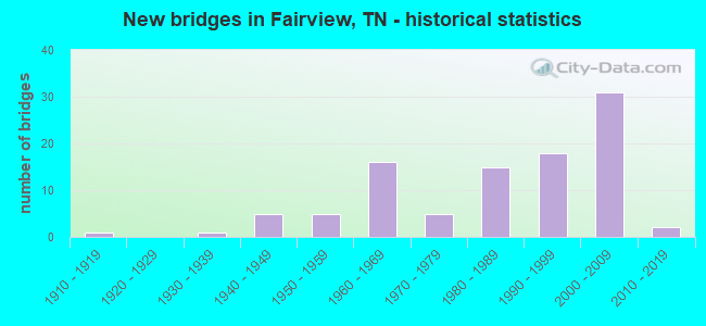
- New bridges - historical statistics
- 11910-1919
- 11930-1939
- 51940-1949
- 51950-1959
- 161960-1969
- 51970-1979
- 151980-1989
- 181990-1999
- 312000-2009
- 22010-2019

- Reconstructed bridges - Historical Statistics
- 11960-1969
- 31970-1979
- 21980-1989
- 11990-1999
- 22000-2009


- Bridge Condition - Deck
- 22.2%Very good
- 55.6%Good
- 8.9%Satisfactory
- 8.9%Fair
- 4.4%Poor

- Bridge Condition - Superstructure
- 13.3%Very good
- 66.7%Good
- 11.1%Satisfactory
- 6.7%Fair
- 2.2%Poor

- Bridge Condition - Substructure
- 6.7%Very good
- 68.9%Good
- 11.1%Satisfactory
- 13.3%Fair

- Bridge Condition - Channel
- 20.9%Very good
- 38.8%Good
- 31.3%Satisfactory
- 7.5%Fair
- 1.5%Poor

- Bridge Condition - Culverts
- 5.3%Very good
- 47.4%Good
- 23.7%Satisfactory
- 23.7%Fair
Find on map >> Show street view
Structure Number: 94SR8400098, Location: NEAR SR-46 (Lat: 35.891450, Lng: -87.120683), Route carried "on" structure: Interstate 840, Year Built: 2009, Status: Open, Structure Length: 14.14m (46.39ft), Average Daily Traffic: 21,236 (year 2020), Truck Traffic: 17%, Average Future Daily Traffic: 34,048 (year 2041), Design Load: HL 93, Features Intersected: COPPERAS BRANCH
Minimum Vertical Clearance: 30+ m (98+ ft), Kilometerpoint: 10.268, Lanes on structure: 2, Base Highway Network: Yes, Owner: State Highway Agency, Approaching Roadway Width: 12.8m (42.0ft), Material/Design: Prestressed concrete continuous, Design/Construction: Stringer/Multi-beam, Number Of Spans In Main Unit: 4, Length of Maximum Span: 35.4m (116.1ft), Curb-To-Curb Width: 13.0m (42.7ft), Out-to-Out Width: 13.4m (44.0ft)
Condition: Deck: Good, Superstructure: Good, Substructure: Good, Channel: Very good, Operating Rating: 54.1 metric tons, Method Used To Determine Operating Rating: Assigned ratings based on Load and Resistance Factor Design (LRFD) reported by rating factor (RF) using HL93 loadings, Inventory Rating: 32.4 metric tons, Method Used To Determine Inventory Rating: Assigned ratings based on Load and Resistance Factor Design (LRFD) reported by rating factor (RF) using HL93 loadings, Structural Evaluation: Better than present minimum criteria, Deck Geometry: Superior to present desirable criteria, Waterway Adequacy: Equal to present desirable criteria, Approach Roadway Alignment: Equal to present desirable criteria, Designated Inspection Frequency: Every 24 months, Inspection Date: January 2021, Deck Structure Type: Concrete Precast Panels, Wearing Surface/Protective System: Wearing Surface: Monolithic Concrete, Deck Protection: Epoxy Coated Reinforcing
Find on map >> Show street view
Structure Number: 11I00400001, Location: NEAR KINGSTON SPRINGS TN. (Lat: 36.051667, Lng: -87.161667), Route carried "under" structure: Interstate 40, Year Built: 1960, Structure Length: 0. m, Average Daily Traffic: 39,391 (year 2020), Truck Traffic: 25%, Features Intersected: FAIRVIEW-KINGSTON SPRING, Facility Carried by Structure: NFA A384
Minimum Vertical Clearance: 5.00m (16.40ft), Kilometerpoint: 0.563, Lanes on structure: 2, Lanes under structure: 4, Material/Design: Steel, Design/Construction: Stringer/Multi-beam, Length of Maximum Span: 22.3m (73.2ft)
Find on map >> Show street view
Structure Number: 41SR8400001, Location: 0.5 MI NW JCT SR46&SR100 (Lat: 35.954617, Lng: -87.216683), Route carried "under" structure: County highway A295, Year Built: 1998, Structure Length: 0. m, Average Daily Traffic: 690 (year 2018), Truck Traffic: 2%, Features Intersected: I840/ NEW CUTTOFF ROAD, Facility Carried by Structure: FAP 840
Minimum Vertical Clearance: 7.21m (23.65ft), Kilometerpoint: 3.573, Lanes on structure: 2, Lanes under structure: 2, Material/Design: Prestressed concrete continuous, Design/Construction: Stringer/Multi-beam, Length of Maximum Span: 19.3m (63.3ft)
Find on map >> Show street view
Structure Number: 41SR8400002, Location: 0.5 MI NW JCT SR46&SR100 (Lat: 35.954617, Lng: -87.216683), Route carried "under" structure: County highway A295, Year Built: 1998, Structure Length: 0. m, Average Daily Traffic: 690 (year 2018), Truck Traffic: 2%, Features Intersected: I840/ NEW CUTTOFF ROAD, Facility Carried by Structure: FAP 840
Minimum Vertical Clearance: 5.44m (17.85ft), Kilometerpoint: 3.605, Lanes on structure: 2, Lanes under structure: 2, Material/Design: Prestressed concrete continuous, Design/Construction: Stringer/Multi-beam, Length of Maximum Span: 18.5m (60.7ft)
Find on map >> Show street view
Structure Number: 94I00400001, Location: 4.7 MI NW JCT SR96&SR100 (Lat: 36.023067, Lng: -87.187900), Route carried "under" structure: County highway 278, Year Built: 1960, Structure Length: 0. m, Average Daily Traffic: 510 (year 2022), Truck Traffic: 2%, Features Intersected: I40 / A278 COUNTY LINE R, Facility Carried by Structure: I40
Minimum Vertical Clearance: 5.08m (16.67ft), Kilometerpoint: 0.135, Lanes on structure: 2, Lanes under structure: 2, Material/Design: Prestressed concrete, Design/Construction: Stringer/Multi-beam, Length of Maximum Span: 13.1m (43.0ft)
Find on map >> Show street view
Structure Number: 94I00400002, Location: 4.7 MI NW JCT SR96&SR100 (Lat: 36.023867, Lng: -87.187750), Route carried "under" structure: County highway 278, Year Built: 1960, Structure Length: 0. m, Average Daily Traffic: 510 (year 2022), Truck Traffic: 2%, Features Intersected: I40 / A278 COUNTY LINE R, Facility Carried by Structure: I40
Minimum Vertical Clearance: 4.88m (16.01ft), Kilometerpoint: 0.164, Lanes on structure: 2, Lanes under structure: 2, Material/Design: Prestressed concrete, Design/Construction: Stringer/Multi-beam, Length of Maximum Span: 13.1m (43.0ft)
Find on map >> Show street view
Structure Number: 94I00400003, Location: NEAR FAIRVIEW TENN. (Lat: 36.027533, Lng: -87.178517), Route carried "under" structure: Interstate 40, Year Built: 1960, Structure Length: 0. m, Average Daily Traffic: 28,523 (year 2020), Truck Traffic: 31%, Features Intersected: SR-96 / I-40, Facility Carried by Structure: FAP 96
Minimum Vertical Clearance: 5.08m (16.67ft), Kilometerpoint: 1.110, Lanes on structure: 2, Lanes under structure: 4, Material/Design: Steel continuous, Design/Construction: Stringer/Multi-beam, Length of Maximum Span: 31.1m (102.0ft)
Find on map >> Show street view
Structure Number: 94SR0960001, Location: NEAR FAIRVIEW TENN. (Lat: 35.983967, Lng: -87.114900), Route carried "under" structure: State highway 96, Year Built: 1957, Structure Length: 0. m, Average Daily Traffic: 6,641 (year 2020), Truck Traffic: 9%, Features Intersected: SR 100 RL / SR 96, Facility Carried by Structure: FAP 100
Minimum Vertical Clearance: 4.93m (16.17ft), Kilometerpoint: 8.417, Lanes on structure: 2, Lanes under structure: 2, Material/Design: Prestressed concrete continuous, Design/Construction: Box Beam or Girders - Single/Spread, Length of Maximum Span: 14.6m (47.9ft)
Find on map >> Show street view
Structure Number: 94SR0960002, Location: NEAR FAIRVIEW TENN. (Lat: 35.984017, Lng: -87.115100), Route carried "under" structure: State highway 96, Year Built: 1957, Structure Length: 0. m, Average Daily Traffic: 6,641 (year 2020), Truck Traffic: 9%, Features Intersected: SR 100 LL / SR 96, Facility Carried by Structure: FAP 100
Minimum Vertical Clearance: 5.57m (18.27ft), Kilometerpoint: 8.385, Lanes on structure: 2, Lanes under structure: 2, Material/Design: Prestressed concrete continuous, Design/Construction: Box Beam or Girders - Single/Spread, Length of Maximum Span: 14.6m (47.9ft)
Find on map >> Show street view
Structure Number: 94SR8400001, Location: 0.5 MI NW JCT SR46&SR100 (Lat: 35.949217, Lng: -87.201100), Route carried "under" structure: County highway 957, Year Built: 2001, Structure Length: 0. m, Average Daily Traffic: 1,583 (year 2020), Truck Traffic: 3%, Features Intersected: I840/957 SPENCER MILL, Facility Carried by Structure: I840
Minimum Vertical Clearance: 5.59m (18.34ft), Kilometerpoint: 1.352, Lanes on structure: 2, Lanes under structure: 2, Material/Design: Prestressed concrete continuous, Design/Construction: Stringer/Multi-beam, Length of Maximum Span: 24.4m (80.1ft)
Find on map >> Show street view
Structure Number: 94SR8400002, Location: 0.5 MI NW JCT SR46&SR100 (Lat: 35.949617, Lng: -87.201017), Route carried "under" structure: County highway 957, Year Built: 2001, Structure Length: 0. m, Average Daily Traffic: 1,583 (year 2020), Truck Traffic: 3%, Features Intersected: I840/957 SPENCER MILL, Facility Carried by Structure: I840
Minimum Vertical Clearance: 5.97m (19.59ft), Kilometerpoint: 1.384, Lanes on structure: 3, Lanes under structure: 2, Material/Design: Prestressed concrete continuous, Design/Construction: Stringer/Multi-beam, Length of Maximum Span: 24.4m (80.1ft)
Find on map >> Show street view
Structure Number: 94SR8400005, Location: 5.6 SW OF SR096 (Lat: 35.939733, Lng: -87.190367), Route carried "under" structure: Alternate US 100, Year Built: 2009, Structure Length: 0. m, Average Daily Traffic: 7,074 (year 2020), Truck Traffic: 9%, Features Intersected: I840 / SR 100, Facility Carried by Structure: I840
Minimum Vertical Clearance: 5.38m (17.65ft), Kilometerpoint: 1.127, Lanes on structure: 3, Lanes under structure: 3, Material/Design: Prestressed concrete continuous, Design/Construction: Stringer/Multi-beam, Length of Maximum Span: 31.4m (103.0ft)
Find on map >> Show street view
Structure Number: 94SR8400006, Location: 5.6 SW OF SR096 (Lat: 35.939733, Lng: -87.190367), Route carried "under" structure: Alternate US 100, Year Built: 2009, Structure Length: 0. m, Average Daily Traffic: 7,074 (year 2020), Truck Traffic: 9%, Features Intersected: I840 / SR 100, Facility Carried by Structure: I840
Minimum Vertical Clearance: 5.44m (17.85ft), Kilometerpoint: 1.159, Lanes on structure: 3, Lanes under structure: 3, Material/Design: Prestressed concrete continuous, Design/Construction: Stringer/Multi-beam, Length of Maximum Span: 31.4m (103.0ft)
Find on map >> Show street view
Structure Number: 94SR8400011, Location: 1.0 MI S JCT. SR100&I840 (Lat: 35.911944, Lng: -87.163017), Route carried "under" structure: Interstate 840, Year Built: 2009, Structure Length: 0. m, Average Daily Traffic: 21,236 (year 2020), Truck Traffic: 17%, Features Intersected: DEER RIDGE RD / I840, Facility Carried by Structure: NFA A027
Minimum Vertical Clearance: 5.09m (16.70ft), Kilometerpoint: 5.745, Lanes on structure: 2, Lanes under structure: 4, Material/Design: Prestressed concrete continuous, Design/Construction: Stringer/Multi-beam, Length of Maximum Span: 45.6m (149.6ft)
Find on map >> Show street view
Structure Number: 94SR8400013, Location: 1.0 MI S JCT. SR100&I840 (Lat: 35.902283, Lng: -87.146500), Route carried "under" structure: Interstate 840, Year Built: 2009, Structure Length: 0. m, Average Daily Traffic: 21,236 (year 2020), Truck Traffic: 17%, Features Intersected: SO. HARPETH RD / I840, Facility Carried by Structure: NFA A038
Minimum Vertical Clearance: 5.09m (16.70ft), Kilometerpoint: 7.596, Lanes on structure: 2, Lanes under structure: 4, Material/Design: Prestressed concrete continuous, Design/Construction: Stringer/Multi-beam, Length of Maximum Span: 45.7m (149.9ft)
Find on map >> Show street view
Structure Number: 94SR8400015, Location: 1.0 MI S JCT. SR100&I840 (Lat: 35.894267, Lng: -87.130767), Route carried "under" structure: Interstate 840, Year Built: 2006, Structure Length: 0. m, Average Daily Traffic: 21,236 (year 2020), Truck Traffic: 17%, Features Intersected: NFA 1917 PEWITT / I840, Facility Carried by Structure: NFA 1917
Minimum Vertical Clearance: 5.44m (17.85ft), Kilometerpoint: 9.270, Lanes on structure: 2, Lanes under structure: 4, Material/Design: Prestressed concrete continuous, Design/Construction: Stringer/Multi-beam, Length of Maximum Span: 46.1m (151.2ft)
Find on map >> Show street view
Structure Number: 95SR0240023, Location: 4.95 MI NW JCT I-40&SR109 (Lat: 35.983967, Lng: -87.114900), Route carried "under" structure: State highway 109, Year Built: 2007, Structure Length: 0. m, Average Daily Traffic: 22,149 (year 2020), Truck Traffic: 9%, Features Intersected: SR 24 / SR 109, Facility Carried by Structure: FAP 24
Minimum Vertical Clearance: 5.89m (19.32ft), Kilometerpoint: 12.151, Lanes on structure: 5, Lanes under structure: 5, Material/Design: Concrete, Design/Construction: Tee Beam, Length of Maximum Span: 37.5m (123.0ft)