Bridge Statistics for Escondido, California (CA)
Condition, Traffic, Stress, Structural Evaluation, Project Costs
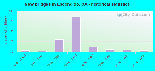
- New bridges - historical statistics
- 31940-1949
- 21950-1959
- 301960-1969
- 861970-1979
- 111980-1989
- 51990-1999
- 42000-2009
- 32010-2019
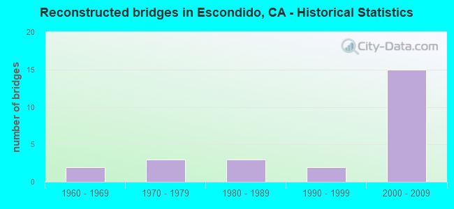
- Reconstructed bridges - Historical Statistics
- 21960-1969
- 31970-1979
- 31980-1989
- 21990-1999
- 152000-2009
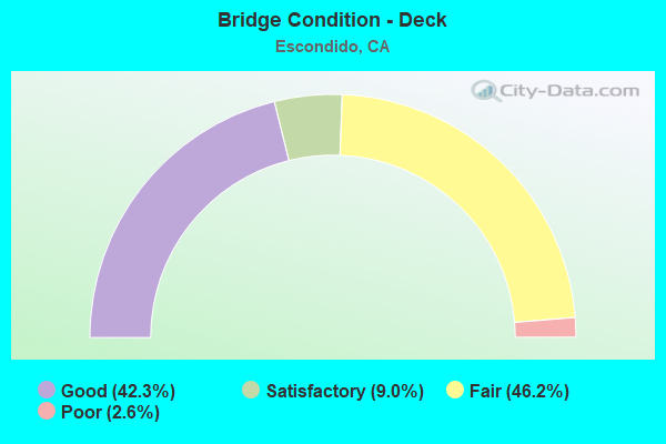
- Bridge Condition - Deck
- 42.3%Good
- 9.0%Satisfactory
- 46.2%Fair
- 2.6%Poor
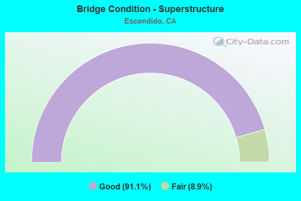
- Bridge Condition - Superstructure
- 91.1%Good
- 8.9%Fair
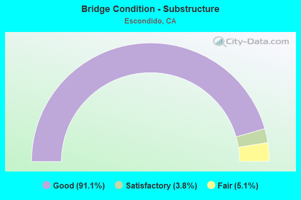
- Bridge Condition - Substructure
- 91.1%Good
- 3.8%Satisfactory
- 5.1%Fair
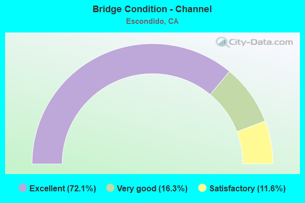
- Bridge Condition - Channel
- 72.1%Excellent
- 16.3%Very good
- 11.6%Satisfactory
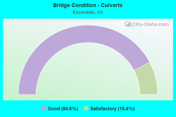
- Bridge Condition - Culverts
- 84.6%Good
- 15.4%Satisfactory
Find on map >> Show street view
Structure Number: 57 0501, Location: 11-SD-015-R6.26-SD (Lat: 32.780508, Lng: -117.112547), Route carried "on" structure: Interstate 15, Year Built: 1960, Year Reconstructed: 1984, Status: Open, Structure Length: 27.92m (91.60ft), Average Daily Traffic: 244,000 (year 2019), Truck Traffic: 5%, Average Future Daily Traffic: 299,733 (year 2041), Design Load: HS 20, Features Intersected: SAN DIEGO RIVER
Minimum Vertical Clearance: 30+ m (98+ ft), Kilometerpoint: 6.260, Lanes on structure: 10, Lanes under structure: 4, Base Highway Network: Yes (, Subroute: 1), Owner: State Highway Agency, Approaching Roadway Width: 51.2m (168.0ft), Skew: 31 degrees, Material/Design: Concrete continuous, Design/Construction: Tee Beam, Number Of Spans In Main Unit: 18, Number Of Approach Spans: 10, Length of Maximum Span: 18.0m (59.1ft), Curb-To-Curb Width: 51.2m (168.0ft), Out-to-Out Width: 52.9m (173.6ft)
Condition: Deck: Fair, Superstructure: Good, Substructure: Good, Channel: Very good, Operating Rating: 69.7 metric tons, Method Used To Determine Operating Rating: Load Factor (LF), Inventory Rating: 41.8 metric tons, Method Used To Determine Inventory Rating: Load Factor (LF), Structural Evaluation: Better than present minimum criteria, Deck Geometry: Superior to present desirable criteria, Underclear: Meets minimum limits, Waterway Adequacy: Equal to present desirable criteria, Approach Roadway Alignment: Equal to present desirable criteria, Length Of Structure Improvement: 27.92m (91.60ft), Designated Inspection Frequency: Every 24 months, Inspection Date: July 2021, Deck Structure Type: Concrete Cast-file-Place
Find on map >> Show street view
Structure Number: 57 0506F, Location: 11-SD-078-R16.66-ESD (Lat: 33.127953, Lng: -117.102689), Route carried "on" structure: Ramp State highway 78, Year Built: 1977, Status: Open, Structure Length: 4.39m (14.40ft), Average Daily Traffic: 9,000 (year 2012), Truck Traffic: 1%, Average Future Daily Traffic: 12,572 (year 2040), Design Load: HS 20+Mod, Features Intersected: METCALF STREET
Minimum Vertical Clearance: 30+ m (98+ ft), Kilometerpoint: 16.660, Lanes on structure: 1, Lanes under structure: 2, Base Highway Network: Yes (, Subroute: 1), Owner: State Highway Agency, Approaching Roadway Width: 8.5m (27.9ft), Material/Design: Prestressed concrete, Design/Construction: Box Beam or Girders - Multiple, Number Of Spans In Main Unit: 1, Length of Maximum Span: 43.6m (143.0ft), Curb-To-Curb Width: 8.5m (27.9ft), Out-to-Out Width: 9.6m (31.5ft)
Condition: Deck: Fair, Superstructure: Good, Substructure: Good, Operating Rating: 97.8 metric tons, Method Used To Determine Operating Rating: Load Factor (LF), Inventory Rating: 32.4 metric tons, Method Used To Determine Inventory Rating: Load Factor (LF), Structural Evaluation: Better than present minimum criteria, Deck Geometry: Superior to present desirable criteria, Underclear: Somewhat better than minimum adequacy, Approach Roadway Alignment: Equal to present desirable criteria, Designated Inspection Frequency: Every 24 months, Inspection Date: April 2021, Deck Structure Type: Concrete Cast-file-Place
Find on map >> Show street view
Structure Number: 57 0506L, Location: 11-SD-078-R16.66-ESD (Lat: 33.127817, Lng: -117.102606), Route carried "on" structure: State highway 78, Year Built: 1964, Status: Open, Structure Length: 4.48m (14.70ft), Average Daily Traffic: 44,500 (year 2012), Truck Traffic: 5%, Average Future Daily Traffic: 58,973 (year 2040), Design Load: HS 20+Mod, Features Intersected: METCALF STREET
Minimum Vertical Clearance: 30+ m (98+ ft), Kilometerpoint: 16.660, Lanes on structure: 2, Lanes under structure: 2, Base Highway Network: Yes (, Subroute: 1), Owner: State Highway Agency, Approaching Roadway Width: 11.6m (38.1ft), Material/Design: Concrete continuous, Design/Construction: Box Beam or Girders - Multiple, Number Of Spans In Main Unit: 3, Length of Maximum Span: 25.0m (82.0ft), Curb-To-Curb Width: 11.6m (38.1ft), Out-to-Out Width: 12.1m (39.7ft)
Condition: Deck: Fair, Superstructure: Good, Substructure: Good, Operating Rating: 42.4 metric tons, Method Used To Determine Operating Rating: Load and Resistance Factor Rating (LRFR) rating reported by rating factor(RF) method using HL-93 loadings, Inventory Rating: 30.1 metric tons, Method Used To Determine Inventory Rating: Load and Resistance Factor Rating (LRFR) rating reported by rating factor(RF) method using HL-93 loadings, Structural Evaluation: Better than present minimum criteria, Deck Geometry: Equal to present minimum criteria, Underclear: Somewhat better than minimum adequacy, Approach Roadway Alignment: Equal to present desirable criteria, Designated Inspection Frequency: Every 24 months, Inspection Date: April 2021, Deck Structure Type: Concrete Cast-file-Place
Find on map >> Show street view
Structure Number: 57 0506R, Location: 11-SD-078-R16.66-ESD (Lat: 33.127636, Lng: -117.102508), Route carried "on" structure: State highway 78, Year Built: 1964, Status: Open, Structure Length: 4.48m (14.70ft), Average Daily Traffic: 44,500 (year 2012), Truck Traffic: 1%, Average Future Daily Traffic: 47,146 (year 2040), Design Load: HS 20+Mod, Features Intersected: METCALF STREET
Minimum Vertical Clearance: 30+ m (98+ ft), Kilometerpoint: 16.660, Lanes on structure: 2, Lanes under structure: 2, Base Highway Network: Yes (, Subroute: 1), Owner: State Highway Agency, Approaching Roadway Width: 11.6m (38.1ft), Material/Design: Concrete continuous, Design/Construction: Box Beam or Girders - Multiple, Number Of Spans In Main Unit: 3, Length of Maximum Span: 25.0m (82.0ft), Curb-To-Curb Width: 11.5m (37.7ft), Out-to-Out Width: 12.1m (39.7ft)
Condition: Deck: Fair, Superstructure: Good, Substructure: Good, Operating Rating: 42.4 metric tons, Method Used To Determine Operating Rating: Load and Resistance Factor Rating (LRFR) rating reported by rating factor(RF) method using HL-93 loadings, Inventory Rating: 30.1 metric tons, Method Used To Determine Inventory Rating: Load and Resistance Factor Rating (LRFR) rating reported by rating factor(RF) method using HL-93 loadings, Structural Evaluation: Better than present minimum criteria, Deck Geometry: Somewhat better than minimum adequacy, Underclear: Somewhat better than minimum adequacy, Approach Roadway Alignment: Equal to present desirable criteria, Designated Inspection Frequency: Every 24 months, Inspection Date: April 2021, Deck Structure Type: Concrete Cast-file-Place
Find on map >> Show street view
Structure Number: 57 0507, Location: 11-SD-078-R16.93-ESD (Lat: 33.129000, Lng: -117.098508), Route carried "on" structure: City street , Year Built: 1964, Year Reconstructed: 1984, Status: Open, Structure Length: 4.72m (15.49ft), Average Daily Traffic: 9,830 (year 2012), Truck Traffic: 1%, Average Future Daily Traffic: 12,573 (year 2041), Design Load: HS 20+Mod, Features Intersected: STATE ROUTE 78, Facility Carried by Structure: ROCK SPRINGS RD
Minimum Vertical Clearance: 30+ m (98+ ft), Kilometerpoint: 0.000, Lanes on structure: 2, Lanes under structure: 6, Owner: State Highway Agency, Approaching Roadway Width: 8.5m (27.9ft), Material/Design: Concrete continuous, Design/Construction: Box Beam or Girders - Multiple, Number Of Spans In Main Unit: 2, Length of Maximum Span: 23.2m (76.1ft), Curb or Sidewalk Widths: Left: 0.0m, Right: 1.5m (4.9ft), Curb-To-Curb Width: 8.5m (27.9ft), Out-to-Out Width: 10.8m (35.4ft)
Condition: Deck: Fair, Superstructure: Fair, Substructure: Good, Operating Rating: 48.3 metric tons, Method Used To Determine Operating Rating: Load and Resistance Factor Rating (LRFR) rating reported by rating factor(RF) method using HL-93 loadings, Inventory Rating: 37.3 metric tons, Method Used To Determine Inventory Rating: Load and Resistance Factor Rating (LRFR) rating reported by rating factor(RF) method using HL-93 loadings, Structural Evaluation: Somewhat better than minimum adequacy, Deck Geometry: High priority of replacement, Underclear: Meets minimum limits, Approach Roadway Alignment: Equal to present desirable criteria, Designated Inspection Frequency: Every 24 months, Inspection Date: April 2021, Deck Structure Type: Concrete Cast-file-Place
Find on map >> Show street view
Structure Number: 57 0508L, Location: 11-SD-078-R17.27-ESD (Lat: 33.130867, Lng: -117.092767), Route carried "on" structure: State highway 78, Year Built: 1964, Year Reconstructed: 1995, Status: Open, Structure Length: 5.79m (19.00ft), Average Daily Traffic: 28,000 (year 2012), Truck Traffic: 5%, Average Future Daily Traffic: 46,264 (year 2040), Design Load: HS 20+Mod, Features Intersected: CENTRE CITY PARKWAY
Minimum Vertical Clearance: 30+ m (98+ ft), Kilometerpoint: 17.270, Lanes on structure: 3, Lanes under structure: 6, Base Highway Network: Yes (, Subroute: 1), Owner: State Highway Agency, Approaching Roadway Width: 16.2m (53.1ft), Material/Design: Concrete continuous, Design/Construction: Box Beam or Girders - Multiple, Number Of Spans In Main Unit: 4, Length of Maximum Span: 23.8m (78.1ft), Curb-To-Curb Width: 16.2m (53.1ft), Out-to-Out Width: 17.0m (55.8ft)
Condition: Deck: Good, Superstructure: Good, Substructure: Good, Operating Rating: 54.1 metric tons, Method Used To Determine Operating Rating: Assigned rating based on Load Factor Design (LFD) reported in metric tons, Inventory Rating: 32.4 metric tons, Method Used To Determine Inventory Rating: Assigned rating based on Load Factor Design (LFD) reported in metric tons, Structural Evaluation: Better than present minimum criteria, Deck Geometry: Better than present minimum criteria, Underclear: Meets minimum limits, Approach Roadway Alignment: Superior to present desirable criteria, Designated Inspection Frequency: Every 48 months, Inspection Date: April 2021, Deck Structure Type: Concrete Cast-file-Place
Find on map >> Show street view
Structure Number: 57 0508R, Location: 11-SD-078-R17.27-ESD (Lat: 33.130658, Lng: -117.092658), Route carried "on" structure: State highway 78, Year Built: 1964, Status: Open, Structure Length: 5.79m (19.00ft), Average Daily Traffic: 28,000 (year 2012), Truck Traffic: 5%, Average Future Daily Traffic: 46,264 (year 2040), Design Load: HS 20+Mod, Features Intersected: CENTRE CITY PARKWAY
Minimum Vertical Clearance: 30+ m (98+ ft), Kilometerpoint: 17.270, Lanes on structure: 2, Lanes under structure: 6, Base Highway Network: Yes (, Subroute: 1), Owner: State Highway Agency, Approaching Roadway Width: 11.6m (38.1ft), Material/Design: Concrete continuous, Design/Construction: Box Beam or Girders - Multiple, Number Of Spans In Main Unit: 4, Length of Maximum Span: 23.8m (78.1ft), Curb-To-Curb Width: 11.5m (37.7ft), Out-to-Out Width: 12.1m (39.7ft)
Condition: Deck: Good, Superstructure: Good, Substructure: Good, Operating Rating: 42.1 metric tons, Method Used To Determine Operating Rating: Load and Resistance Factor Rating (LRFR) rating reported by rating factor(RF) method using HL-93 loadings, Inventory Rating: 32.4 metric tons, Method Used To Determine Inventory Rating: Load and Resistance Factor Rating (LRFR) rating reported by rating factor(RF) method using HL-93 loadings, Structural Evaluation: Better than present minimum criteria, Deck Geometry: Equal to present minimum criteria, Underclear: Meets minimum limits, Approach Roadway Alignment: Equal to present desirable criteria, Designated Inspection Frequency: Every 48 months, Inspection Date: April 2021, Deck Structure Type: Concrete Cast-file-Place
Find on map >> Show street view
Structure Number: 57 0508S, Location: 11-SD-078-R17.27-ESD (Lat: 33.130531, Lng: -117.092606), Route carried "on" structure: Ramp State highway 78, Year Built: 1964, Status: Open, Structure Length: 5.79m (19.00ft), Average Daily Traffic: 3,900 (year 2009), Truck Traffic: 1%, Average Future Daily Traffic: 7,858 (year 2038), Design Load: HS 20, Features Intersected: CENTRE CITY PARKWAY
Minimum Vertical Clearance: 30+ m (98+ ft), Kilometerpoint: 17.270, Lanes on structure: 1, Lanes under structure: 6, Base Highway Network: Yes (, Subroute: 1), Owner: State Highway Agency, Approaching Roadway Width: 6.7m (22.0ft), Material/Design: Concrete continuous, Design/Construction: Box Beam or Girders - Multiple, Number Of Spans In Main Unit: 4, Length of Maximum Span: 23.8m (78.1ft), Curb or Sidewalk Widths: Left: 0.6m (2.0ft), Right: 0.0m, Curb-To-Curb Width: 6.8m (22.3ft), Out-to-Out Width: 8.0m (26.2ft)
Condition: Deck: Good, Superstructure: Good, Substructure: Good, Operating Rating: 47.0 metric tons, Method Used To Determine Operating Rating: Load and Resistance Factor Rating (LRFR) rating reported by rating factor(RF) method using HL-93 loadings, Inventory Rating: 36.0 metric tons, Method Used To Determine Inventory Rating: Load and Resistance Factor Rating (LRFR) rating reported by rating factor(RF) method using HL-93 loadings, Structural Evaluation: Better than present minimum criteria, Deck Geometry: Equal to present minimum criteria, Underclear: Meets minimum limits, Approach Roadway Alignment: Equal to present desirable criteria, Designated Inspection Frequency: Every 48 months, Inspection Date: April 2019, Deck Structure Type: Concrete Cast-file-Place
Find on map >> Show street view
Structure Number: 57 0579, Location: 11-SD-078-R17.23-ESD (Lat: 33.130419, Lng: -117.093728), Route carried "on" structure: State highway 78, Year Built: 1964, Status: Open, Structure Length: 1.37m (4.49ft), Average Daily Traffic: 89,000 (year 2011), Truck Traffic: 5%, Average Future Daily Traffic: 104,770 (year 2038), Design Load: HS 20, Features Intersected: REIDY CREEK
Minimum Vertical Clearance: 30+ m (98+ ft), Kilometerpoint: 17.230, Lanes on structure: 7, Base Highway Network: Yes (, Subroute: 1), Owner: State Highway Agency, Approaching Roadway Width: 45.1m (148.0ft), Skew: 20 degrees, Material/Design: Concrete, Design/Construction: Culvert, Number Of Spans In Main Unit: 4, Length of Maximum Span: 3.0m (9.8ft)
Condition: Channel: Excellent, Culverts: Good, Operating Rating: 54.1 metric tons, Method Used To Determine Operating Rating: Field evaluation and documented engineering judgment, Inventory Rating: 32.4 metric tons, Method Used To Determine Inventory Rating: Field evaluation and documented engineering judgment, Structural Evaluation: Better than present minimum criteria, Waterway Adequacy: Superior to present desirable criteria, Approach Roadway Alignment: Equal to present desirable criteria, Designated Inspection Frequency: Every 48 months, Inspection Date: April 2019
Find on map >> Show street view
Structure Number: 57 0592L, Location: 11-SD-078-R17.41-ESD (Lat: 33.131550, Lng: -117.090464), Route carried "on" structure: State highway 78, Year Built: 1995, Status: Open, Structure Length: 4.75m (15.58ft), Average Daily Traffic: 28,000 (year 2011), Truck Traffic: 5%, Average Future Daily Traffic: 46,264 (year 2038), Design Load: HS 20+Mod, Features Intersected: ESCONDIDO BLVD
Minimum Vertical Clearance: 30+ m (98+ ft), Kilometerpoint: 17.410, Lanes on structure: 2, Lanes under structure: 4, Base Highway Network: Yes (, Subroute: 1), Owner: State Highway Agency, Approaching Roadway Width: 11.9m (39.0ft), Material/Design: Prestressed concrete continuous, Design/Construction: Box Beam or Girders - Multiple, Number Of Spans In Main Unit: 3, Length of Maximum Span: 25.6m (84.0ft), Curb-To-Curb Width: 11.9m (39.0ft), Out-to-Out Width: 12.9m (42.3ft)
Condition: Deck: Fair, Superstructure: Good, Substructure: Good, Operating Rating: 54.1 metric tons, Method Used To Determine Operating Rating: Assigned rating based on Load Factor Design (LFD) reported in metric tons, Inventory Rating: 32.4 metric tons, Method Used To Determine Inventory Rating: Assigned rating based on Load Factor Design (LFD) reported in metric tons, Structural Evaluation: Better than present minimum criteria, Deck Geometry: Somewhat better than minimum adequacy, Underclear: Meets minimum limits, Approach Roadway Alignment: Superior to present desirable criteria, Designated Inspection Frequency: Every 24 months, Inspection Date: May 2021, Deck Structure Type: Concrete Cast-file-Place
Find on map >> Show street view
Structure Number: 57 0592R, Location: 11-SD-078-R17.41-ESD (Lat: 33.131344, Lng: -117.090378), Route carried "on" structure: State highway 78, Year Built: 1967, Status: Open, Structure Length: 4.69m (15.39ft), Average Daily Traffic: 28,000 (year 2012), Truck Traffic: 5%, Average Future Daily Traffic: 46,264 (year 2040), Design Load: HS 20, Features Intersected: ESCONDIDO BLVD
Minimum Vertical Clearance: 30+ m (98+ ft), Kilometerpoint: 17.410, Lanes on structure: 2, Lanes under structure: 4, Base Highway Network: Yes (, Subroute: 1), Owner: State Highway Agency, Approaching Roadway Width: 10.2m (33.5ft), Material/Design: Concrete continuous, Design/Construction: Box Beam or Girders - Multiple, Number Of Spans In Main Unit: 3, Length of Maximum Span: 25.6m (84.0ft), Curb-To-Curb Width: 10.2m (33.5ft), Out-to-Out Width: 12.5m (41.0ft)
Condition: Deck: Fair, Superstructure: Good, Substructure: Fair, Operating Rating: 42.1 metric tons, Method Used To Determine Operating Rating: Load and Resistance Factor Rating (LRFR) rating reported by rating factor(RF) method using HL-93 loadings, Inventory Rating: 32.7 metric tons, Method Used To Determine Inventory Rating: Load and Resistance Factor Rating (LRFR) rating reported by rating factor(RF) method using HL-93 loadings, Structural Evaluation: Somewhat better than minimum adequacy, Deck Geometry: Somewhat better than minimum adequacy, Underclear: Superior to present desirable criteria, Approach Roadway Alignment: Equal to present minimum criteria, Designated Inspection Frequency: Every 24 months, Inspection Date: May 2021, Deck Structure Type: Concrete Cast-file-Place
Find on map >> Show street view
Structure Number: 57 0623, Location: 11-SD-015-M26.97-ESD (Lat: 33.069264, Lng: -117.069931), Route carried "on" structure: City street S410, Year Built: 1968, Year Reconstructed: 1985, Status: Open, Structure Length: 9.69m (31.79ft), Average Daily Traffic: 45,380 (year 2020), Truck Traffic: 2%, Average Future Daily Traffic: 51,620 (year 2040), Design Load: HS 20, Features Intersected: INTERSTATE 15 W/HOV, Facility Carried by Structure: VIA RANCHO PKWY
Minimum Vertical Clearance: 30+ m (98+ ft), Kilometerpoint: 0.000, Lanes on structure: 5, Lanes under structure: 15, Base Highway Network: Yes, Owner: State Highway Agency, Approaching Roadway Width: 29.0m (95.1ft), Skew: 2 degrees, Material/Design: Concrete continuous, Design/Construction: Box Beam or Girders - Multiple, Number Of Spans In Main Unit: 2, Length of Maximum Span: 50.0m (164.0ft), Curb or Sidewalk Widths: Left: 1.5m (4.9ft), Right: 1.5m (4.9ft), Curb-To-Curb Width: 28.7m (94.2ft), Out-to-Out Width: 32.3m (106.0ft)
Condition: Deck: Fair, Superstructure: Good, Substructure: Good, Operating Rating: 49.2 metric tons, Method Used To Determine Operating Rating: Load and Resistance Factor Rating (LRFR) rating reported by rating factor(RF) method using HL-93 loadings, Inventory Rating: 37.6 metric tons, Method Used To Determine Inventory Rating: Load and Resistance Factor Rating (LRFR) rating reported by rating factor(RF) method using HL-93 loadings, Structural Evaluation: Better than present minimum criteria, Deck Geometry: Superior to present desirable criteria, Underclear: Meets minimum limits, Approach Roadway Alignment: Equal to present desirable criteria, Designated Inspection Frequency: Every 24 months, Inspection Date: November 2021, Deck Structure Type: Concrete Cast-file-Place
Find on map >> Show street view
Structure Number: 57 0801L, Location: 11-SD-094-M10.25L (Lat: 32.753947, Lng: -117.010836), Route carried "on" structure: State highway 94, Year Built: 1976, Status: Open, Structure Length: 34.59m (113.48ft), Average Daily Traffic: 43,500 (year 2020), Truck Traffic: 6%, Average Future Daily Traffic: 66,532 (year 2041), Design Load: HS 20+Mod, Features Intersected: SR 125,CAMPO-N125,SPRING
Minimum Vertical Clearance: 30+ m (98+ ft), Kilometerpoint: 10.250, Lanes on structure: 3, Lanes under structure: 15, Base Highway Network: Yes (, Subroute: 1), Owner: State Highway Agency, Approaching Roadway Width: 15.2m (49.9ft), Material/Design: Prestressed concrete continuous, Design/Construction: Box Beam or Girders - Multiple, Number Of Spans In Main Unit: 3, Number Of Approach Spans: 4, Length of Maximum Span: 65.2m (213.9ft), Curb-To-Curb Width: 15.3m (50.2ft), Out-to-Out Width: 16.4m (53.8ft)
Condition: Deck: Fair, Superstructure: Good, Substructure: Good, Operating Rating: 99.8 metric tons, Method Used To Determine Operating Rating: Load Factor (LF), Inventory Rating: 32.4 metric tons, Method Used To Determine Inventory Rating: Load Factor (LF), Structural Evaluation: Better than present minimum criteria, Deck Geometry: Meets minimum limits, Underclear: High priority of corrective action, Approach Roadway Alignment: Equal to present desirable criteria, Designated Inspection Frequency: Every 24 months, Inspection Date: January 2021, Deck Structure Type: Concrete Cast-file-Place
Find on map >> Show street view
Structure Number: 57 0805L, Location: 11-SD-015-M27.76 (Lat: 33.080514, Lng: -117.072136), Route carried "on" structure: Interstate 15, Year Built: 1977, Year Reconstructed: 2011, Status: Open, Structure Length: 4.04m (13.25ft), Average Daily Traffic: 110,000 (year 2019), Truck Traffic: 7%, Average Future Daily Traffic: 164,844 (year 2042), Design Load: HS 20, Features Intersected: SO CENTRE CITY PARKWAY
Minimum Vertical Clearance: 30+ m (98+ ft), Kilometerpoint: 27.760, Lanes on structure: 6, Lanes under structure: 2, Base Highway Network: Yes (, Subroute: 1), Owner: State Highway Agency, Approaching Roadway Width: 27.3m (89.6ft), Skew: 2 degrees, Material/Design: Prestressed concrete, Design/Construction: Box Beam or Girders - Multiple, Number Of Spans In Main Unit: 1, Length of Maximum Span: 40.1m (131.6ft), Curb-To-Curb Width: 27.8m (91.2ft), Out-to-Out Width: 28.7m (94.2ft)
Condition: Deck: Good, Superstructure: Fair, Substructure: Good, Operating Rating: 44.1 metric tons, Method Used To Determine Operating Rating: Load and Resistance Factor Rating (LRFR) rating reported by rating factor(RF) method using HL-93 loadings, Inventory Rating: 33.7 metric tons, Method Used To Determine Inventory Rating: Load and Resistance Factor Rating (LRFR) rating reported by rating factor(RF) method using HL-93 loadings, Structural Evaluation: Somewhat better than minimum adequacy, Deck Geometry: Equal to present minimum criteria, Underclear: High priority of corrective action, Approach Roadway Alignment: Equal to present desirable criteria, Designated Inspection Frequency: Every 24 months, Inspection Date: November 2021, Deck Structure Type: Concrete Cast-file-Place
Find on map >> Show street view
Structure Number: 57 0805R, Location: 11-SD-015-M27.76 (Lat: 33.080742, Lng: -117.071861), Route carried "on" structure: Interstate 15, Year Built: 1977, Year Reconstructed: 2011, Status: Open, Structure Length: 4.56m (14.96ft), Average Daily Traffic: 120,000 (year 2019), Truck Traffic: 7%, Average Future Daily Traffic: 174,844 (year 2042), Design Load: HS 20, Features Intersected: SO CENTRE CITY PARKWAY
Minimum Vertical Clearance: 30+ m (98+ ft), Kilometerpoint: 27.760, Lanes on structure: 7, Lanes under structure: 2, Base Highway Network: Yes (, Subroute: 1), Owner: State Highway Agency, Approaching Roadway Width: 30.7m (100.7ft), Skew: 9 degrees, Material/Design: Prestressed concrete, Design/Construction: Box Beam or Girders - Multiple, Number Of Spans In Main Unit: 1, Length of Maximum Span: 45.3m (148.6ft), Curb-To-Curb Width: 32.1m (105.3ft), Out-to-Out Width: 33.0m (108.3ft)
Condition: Deck: Good, Superstructure: Fair, Substructure: Good, Operating Rating: 46.0 metric tons, Method Used To Determine Operating Rating: Load and Resistance Factor Rating (LRFR) rating reported by rating factor(RF) method using HL-93 loadings, Inventory Rating: 32.1 metric tons, Method Used To Determine Inventory Rating: Load and Resistance Factor Rating (LRFR) rating reported by rating factor(RF) method using HL-93 loadings, Structural Evaluation: Somewhat better than minimum adequacy, Deck Geometry: Better than present minimum criteria, Underclear: High priority of corrective action, Approach Roadway Alignment: Equal to present desirable criteria, Designated Inspection Frequency: Every 24 months, Inspection Date: November 2021, Deck Structure Type: Concrete Cast-file-Place
Find on map >> Show street view
Structure Number: 57 0806L, Location: 11-SD-015-R28.77-ESD (Lat: 33.092197, Lng: -117.082444), Route carried "on" structure: Interstate 15, Year Built: 1977, Year Reconstructed: 2011, Status: Open, Structure Length: 9.59m (31.46ft), Average Daily Traffic: 99,500 (year 2017), Truck Traffic: 7%, Average Future Daily Traffic: 174,844 (year 2042), Design Load: HS 20, Features Intersected: CITRACADO PARKWAY
Minimum Vertical Clearance: 30+ m (98+ ft), Kilometerpoint: 28.770, Lanes on structure: 6, Lanes under structure: 5, Base Highway Network: Yes (, Subroute: 1), Owner: State Highway Agency, Approaching Roadway Width: 27.7m (90.9ft), Skew: 5 degrees, Material/Design: Prestressed concrete continuous, Design/Construction: Box Beam or Girders - Multiple, Number Of Spans In Main Unit: 2, Length of Maximum Span: 47.8m (156.8ft), Curb-To-Curb Width: 27.7m (90.9ft), Out-to-Out Width: 28.5m (93.5ft)
Condition: Deck: Good, Superstructure: Good, Substructure: Good, Operating Rating: 99.8 metric tons, Method Used To Determine Operating Rating: Load Factor (LF), Inventory Rating: 32.4 metric tons, Method Used To Determine Inventory Rating: Load Factor (LF), Structural Evaluation: Better than present minimum criteria, Deck Geometry: Equal to present minimum criteria, Underclear: Equal to present minimum criteria, Approach Roadway Alignment: Equal to present desirable criteria, Designated Inspection Frequency: Every 24 months, Inspection Date: November 2021, Deck Structure Type: Concrete Cast-file-Place
Find on map >> Show street view
Structure Number: 57 0806R, Location: 11-SD-015-R28.77-ESD (Lat: 33.092089, Lng: -117.081808), Route carried "on" structure: Interstate 15, Year Built: 1977, Year Reconstructed: 2011, Status: Open, Structure Length: 9.59m (31.46ft), Average Daily Traffic: 120,000 (year 2017), Truck Traffic: 7%, Average Future Daily Traffic: 174,844 (year 2042), Design Load: HS 20, Features Intersected: CITRACADO PARKWAY
Minimum Vertical Clearance: 30+ m (98+ ft), Kilometerpoint: 28.770, Lanes on structure: 7, Lanes under structure: 5, Base Highway Network: Yes (, Subroute: 1), Owner: State Highway Agency, Approaching Roadway Width: 32.8m (107.6ft), Skew: 5 degrees, Material/Design: Prestressed concrete continuous, Design/Construction: Box Beam or Girders - Multiple, Number Of Spans In Main Unit: 2, Length of Maximum Span: 47.8m (156.8ft), Curb-To-Curb Width: 32.8m (107.6ft), Out-to-Out Width: 33.7m (110.6ft)
Condition: Deck: Fair, Superstructure: Good, Substructure: Good, Operating Rating: 99.8 metric tons, Method Used To Determine Operating Rating: Load Factor (LF), Inventory Rating: 32.4 metric tons, Method Used To Determine Inventory Rating: Load Factor (LF), Structural Evaluation: Better than present minimum criteria, Deck Geometry: Better than present minimum criteria, Underclear: Equal to present minimum criteria, Approach Roadway Alignment: Equal to present desirable criteria, Designated Inspection Frequency: Every 24 months, Inspection Date: November 2021, Deck Structure Type: Concrete Cast-file-Place
Find on map >> Show street view
Structure Number: 57 0807L, Location: 11-SD-015-R28.89-ESD (Lat: 33.093528, Lng: -117.083778), Route carried "on" structure: Interstate 15, Year Built: 1977, Year Reconstructed: 2011, Status: Open, Structure Length: 6.72m (22.05ft), Average Daily Traffic: 110,000 (year 2019), Truck Traffic: 7%, Average Future Daily Traffic: 154,844 (year 2042), Design Load: HS 20, Features Intersected: FELICITA ROAD
Minimum Vertical Clearance: 30+ m (98+ ft), Kilometerpoint: 28.890, Lanes on structure: 6, Lanes under structure: 2, Base Highway Network: Yes (, Subroute: 1), Owner: State Highway Agency, Approaching Roadway Width: 27.7m (90.9ft), Skew: 3 degrees, Material/Design: Prestressed concrete continuous, Design/Construction: Box Beam or Girders - Multiple, Number Of Spans In Main Unit: 3, Length of Maximum Span: 33.1m (108.6ft), Curb-To-Curb Width: 27.7m (90.9ft), Out-to-Out Width: 28.6m (93.8ft)
Condition: Deck: Good, Superstructure: Good, Substructure: Good, Operating Rating: 51.8 metric tons, Method Used To Determine Operating Rating: Load and Resistance Factor Rating (LRFR) rating reported by rating factor(RF) method using HL-93 loadings, Inventory Rating: 33.4 metric tons, Method Used To Determine Inventory Rating: Load and Resistance Factor Rating (LRFR) rating reported by rating factor(RF) method using HL-93 loadings, Structural Evaluation: Better than present minimum criteria, Deck Geometry: Equal to present minimum criteria, Underclear: Somewhat better than minimum adequacy, Approach Roadway Alignment: Equal to present desirable criteria, Designated Inspection Frequency: Every 24 months, Inspection Date: November 2021, Deck Structure Type: Concrete Cast-file-Place
Find on map >> Show street view
Structure Number: 57 0807R, Location: 11-SD-015-R28.89-ESD (Lat: 33.093958, Lng: -117.083678), Route carried "on" structure: Interstate 15, Year Built: 1977, Year Reconstructed: 2011, Status: Open, Structure Length: 6.72m (22.05ft), Average Daily Traffic: 145,000 (year 2019), Truck Traffic: 7%, Average Future Daily Traffic: 174,844 (year 2042), Design Load: HS 20, Features Intersected: FELICITA ROAD
Minimum Vertical Clearance: 30+ m (98+ ft), Kilometerpoint: 28.890, Lanes on structure: 8, Lanes under structure: 2, Base Highway Network: Yes (, Subroute: 1), Owner: State Highway Agency, Approaching Roadway Width: 36.9m (121.1ft), Skew: 3 degrees, Material/Design: Prestressed concrete continuous, Design/Construction: Box Beam or Girders - Multiple, Number Of Spans In Main Unit: 3, Length of Maximum Span: 33.1m (108.6ft), Curb-To-Curb Width: 36.9m (121.1ft), Out-to-Out Width: 37.8m (124.0ft)
Condition: Deck: Fair, Superstructure: Good, Substructure: Good, Operating Rating: 78.1 metric tons, Method Used To Determine Operating Rating: Load Factor (LF), Inventory Rating: 32.4 metric tons, Method Used To Determine Inventory Rating: Load Factor (LF), Structural Evaluation: Better than present minimum criteria, Deck Geometry: Equal to present desirable criteria, Underclear: Equal to present minimum criteria, Approach Roadway Alignment: Equal to present desirable criteria, Designated Inspection Frequency: Every 24 months, Inspection Date: November 2021, Deck Structure Type: Concrete Cast-file-Place
Find on map >> Show street view
Structure Number: 57 0808, Location: 11-SD-015-R30.09-ESD (Lat: 33.108217, Lng: -117.094489), Route carried "on" structure: Interstate 15, Year Built: 1977, Year Reconstructed: 2012, Status: Open, Structure Length: 6.00m (19.69ft), Average Daily Traffic: 99,500 (year 2018), Truck Traffic: 7%, Average Future Daily Traffic: 168,000 (year 2042), Design Load: HS 20, Features Intersected: NINTH AVENUE
Minimum Vertical Clearance: 30+ m (98+ ft), Kilometerpoint: 30.090, Lanes on structure: 14, Lanes under structure: 6, Base Highway Network: Yes (, Subroute: 1), Owner: State Highway Agency, Approaching Roadway Width: 61.1m (200.5ft), Skew: 2 degrees, Material/Design: Prestressed concrete, Design/Construction: Box Beam or Girders - Multiple, Number Of Spans In Main Unit: 1, Length of Maximum Span: 59.7m (195.9ft), Curb-To-Curb Width: 61.1m (200.5ft), Out-to-Out Width: 62.7m (205.7ft)
Condition: Deck: Good, Superstructure: Good, Substructure: Good, Operating Rating: 60.6 metric tons, Method Used To Determine Operating Rating: Load and Resistance Factor Rating (LRFR) rating reported by rating factor(RF) method using HL-93 loadings, Inventory Rating: 46.7 metric tons, Method Used To Determine Inventory Rating: Load and Resistance Factor Rating (LRFR) rating reported by rating factor(RF) method using HL-93 loadings, Structural Evaluation: Better than present minimum criteria, Deck Geometry: Superior to present desirable criteria, Underclear: Somewhat better than minimum adequacy, Approach Roadway Alignment: Superior to present desirable criteria, Designated Inspection Frequency: Every 24 months, Inspection Date: March 2020, Deck Structure Type: Concrete Cast-file-Place
Find on map >> Show street view
Structure Number: 57 0809L, Location: 11-SD-015-R30.63-ESD (Lat: 33.115169, Lng: -117.098883), Route carried "on" structure: Interstate 15, Year Built: 1977, Year Reconstructed: 2011, Status: Open, Structure Length: 6.41m (21.03ft), Average Daily Traffic: 90,500 (year 2018), Truck Traffic: 7%, Average Future Daily Traffic: 100,000 (year 2039), Design Load: HS 20, Features Intersected: VALLEY PARKWAY
Minimum Vertical Clearance: 30+ m (98+ ft), Kilometerpoint: 30.630, Lanes on structure: 8, Lanes under structure: 7, Base Highway Network: Yes (, Subroute: 1), Owner: State Highway Agency, Approaching Roadway Width: 37.7m (123.7ft), Skew: 1 degrees, Material/Design: Concrete continuous, Design/Construction: Box Beam or Girders - Multiple, Number Of Spans In Main Unit: 2, Length of Maximum Span: 33.1m (108.6ft), Curb-To-Curb Width: 37.7m (123.7ft), Out-to-Out Width: 38.3m (125.7ft)
Condition: Deck: Good, Superstructure: Good, Substructure: Good, Operating Rating: 99.8 metric tons, Method Used To Determine Operating Rating: Load Factor (LF), Inventory Rating: 66.1 metric tons, Method Used To Determine Inventory Rating: Load Factor (LF), Structural Evaluation: Better than present minimum criteria, Deck Geometry: Superior to present desirable criteria, Underclear: Equal to present minimum criteria, Approach Roadway Alignment: Equal to present desirable criteria, Designated Inspection Frequency: Every 24 months, Inspection Date: March 2020, Deck Structure Type: Concrete Cast-file-Place
Find on map >> Show street view
Structure Number: 57 0809R, Location: 11-SD-015-R30.63-ESD (Lat: 33.115369, Lng: -117.098564), Route carried "on" structure: Interstate 15, Year Built: 1977, Year Reconstructed: 2011, Status: Open, Structure Length: 6.31m (20.70ft), Average Daily Traffic: 90,500 (year 2018), Truck Traffic: 7%, Average Future Daily Traffic: 100,000 (year 2042), Design Load: HS 20, Features Intersected: VALLEY PARKWAY
Minimum Vertical Clearance: 30+ m (98+ ft), Kilometerpoint: 30.630, Lanes on structure: 8, Lanes under structure: 7, Base Highway Network: Yes (, Subroute: 1), Owner: State Highway Agency, Approaching Roadway Width: 31.9m (104.7ft), Skew: 1 degrees, Material/Design: Concrete continuous, Design/Construction: Box Beam or Girders - Multiple, Number Of Spans In Main Unit: 2, Length of Maximum Span: 32.7m (107.3ft), Curb-To-Curb Width: 31.9m (104.7ft), Out-to-Out Width: 32.9m (107.9ft)
Condition: Deck: Fair, Superstructure: Good, Substructure: Good, Operating Rating: 94.0 metric tons, Method Used To Determine Operating Rating: Load Factor (LF), Inventory Rating: 56.7 metric tons, Method Used To Determine Inventory Rating: Load Factor (LF), Structural Evaluation: Better than present minimum criteria, Deck Geometry: Meets minimum limits, Underclear: Meets minimum limits, Approach Roadway Alignment: Superior to present desirable criteria, Designated Inspection Frequency: Every 24 months, Inspection Date: March 2020, Deck Structure Type: Concrete Cast-file-Place
Find on map >> Show street view
Structure Number: 57 0810L, Location: 11-SD-015-R30.81-ESD (Lat: 33.117575, Lng: -117.100236), Route carried "on" structure: Interstate 15, Year Built: 1977, Year Reconstructed: 2011, Status: Open, Structure Length: 5.80m (19.03ft), Average Daily Traffic: 97,000 (year 2010), Truck Traffic: 7%, Average Future Daily Traffic: 168,000 (year 2039), Design Load: HS 20, Features Intersected: ESCONDIDO FLD CNTRL CHNL
Minimum Vertical Clearance: 30+ m (98+ ft), Kilometerpoint: 30.810, Lanes on structure: 7, Base Highway Network: Yes (, Subroute: 1), Owner: State Highway Agency, Approaching Roadway Width: 36.1m (118.4ft), Material/Design: Prestressed concrete, Design/Construction: Box Beam or Girders - Multiple, Number Of Spans In Main Unit: 1, Length of Maximum Span: 58.0m (190.3ft), Curb-To-Curb Width: 36.1m (118.4ft), Out-to-Out Width: 37.1m (121.7ft)
Condition: Deck: Fair, Superstructure: Good, Substructure: Good, Channel: Very good, Operating Rating: 80.4 metric tons, Method Used To Determine Operating Rating: Load Factor (LF), Inventory Rating: 32.4 metric tons, Method Used To Determine Inventory Rating: Load Factor (LF), Structural Evaluation: Better than present minimum criteria, Deck Geometry: Superior to present desirable criteria, Waterway Adequacy: Equal to present desirable criteria, Approach Roadway Alignment: Superior to present desirable criteria, Designated Inspection Frequency: Every 24 months, Inspection Date: March 2020, Deck Structure Type: Concrete Cast-file-Place
Find on map >> Show street view
Structure Number: 57 0810R, Location: 11-SD-015-R30.81-ESD (Lat: 33.117711, Lng: -117.099692), Route carried "on" structure: Interstate 15, Year Built: 1977, Year Reconstructed: 2011, Status: Open, Structure Length: 5.79m (19.00ft), Average Daily Traffic: 97,000 (year 2018), Truck Traffic: 7%, Average Future Daily Traffic: 168,000 (year 2042), Design Load: HS 20, Features Intersected: ESCONDIDO FLD CNTRL CHNL
Minimum Vertical Clearance: 30+ m (98+ ft), Kilometerpoint: 30.810, Lanes on structure: 9, Base Highway Network: Yes (, Subroute: 1), Owner: State Highway Agency, Approaching Roadway Width: 46.7m (153.2ft), Skew: 9 degrees, Material/Design: Prestressed concrete, Design/Construction: Box Beam or Girders - Multiple, Number Of Spans In Main Unit: 1, Length of Maximum Span: 57.9m (190.0ft), Curb-To-Curb Width: 46.7m (153.2ft), Out-to-Out Width: 47.7m (156.5ft)
Condition: Deck: Fair, Superstructure: Good, Substructure: Good, Channel: Very good, Operating Rating: 58.3 metric tons, Method Used To Determine Operating Rating: Load and Resistance Factor Rating (LRFR) rating reported by rating factor(RF) method using HL-93 loadings, Inventory Rating: 40.5 metric tons, Method Used To Determine Inventory Rating: Load and Resistance Factor Rating (LRFR) rating reported by rating factor(RF) method using HL-93 loadings, Structural Evaluation: Better than present minimum criteria, Deck Geometry: Superior to present desirable criteria, Waterway Adequacy: Equal to present desirable criteria, Approach Roadway Alignment: Superior to present desirable criteria, Designated Inspection Frequency: Every 24 months, Inspection Date: March 2020, Deck Structure Type: Concrete Cast-file-Place
Find on map >> Show street view
Structure Number: 57 0811L, Location: 11-SD-015-R30.97-ESD (Lat: 33.119628, Lng: -117.101500), Route carried "on" structure: Interstate 15, Year Built: 1977, Year Reconstructed: 2011, Status: Open, Structure Length: 5.52m (18.11ft), Average Daily Traffic: 97,000 (year 2018), Truck Traffic: 7%, Average Future Daily Traffic: 168,000 (year 2041), Design Load: HS 20, Features Intersected: HALE AVENUE
Minimum Vertical Clearance: 30+ m (98+ ft), Kilometerpoint: 30.970, Lanes on structure: 7, Lanes under structure: 4, Base Highway Network: Yes (, Subroute: 1), Owner: State Highway Agency, Approaching Roadway Width: 35.2m (115.5ft), Skew: 3 degrees, Material/Design: Prestressed concrete, Design/Construction: Box Beam or Girders - Multiple, Number Of Spans In Main Unit: 1, Length of Maximum Span: 55.2m (181.1ft), Curb-To-Curb Width: 35.2m (115.5ft), Out-to-Out Width: 36.1m (118.4ft)
Condition: Deck: Fair, Superstructure: Good, Substructure: Good, Operating Rating: 85.2 metric tons, Method Used To Determine Operating Rating: Load Factor (LF), Inventory Rating: 32.4 metric tons, Method Used To Determine Inventory Rating: Load Factor (LF), Structural Evaluation: Better than present minimum criteria, Deck Geometry: Superior to present desirable criteria, Underclear: Equal to present minimum criteria, Approach Roadway Alignment: Equal to present desirable criteria, Designated Inspection Frequency: Every 24 months, Inspection Date: March 2020, Deck Structure Type: Concrete Cast-file-Place
Find on map >> Show street view
Structure Number: 57 0811R, Location: 11-SD-015-R30.97-ESD (Lat: 33.120153, Lng: -117.101189), Route carried "on" structure: Interstate 15, Year Built: 1977, Status: Open, Structure Length: 5.47m (17.95ft), Average Daily Traffic: 97,000 (year 2018), Truck Traffic: 7%, Average Future Daily Traffic: 168,000 (year 2042), Design Load: HS 20, Features Intersected: HALE AVENUE
Minimum Vertical Clearance: 30+ m (98+ ft), Kilometerpoint: 30.970, Lanes on structure: 7, Lanes under structure: 4, Base Highway Network: Yes (, Subroute: 1), Owner: State Highway Agency, Approaching Roadway Width: 43.3m (142.1ft), Skew: 3 degrees, Material/Design: Prestressed concrete, Design/Construction: Box Beam or Girders - Multiple, Number Of Spans In Main Unit: 1, Length of Maximum Span: 54.7m (179.5ft), Curb-To-Curb Width: 43.3m (142.1ft), Out-to-Out Width: 44.2m (145.0ft)
Condition: Deck: Fair, Superstructure: Good, Substructure: Good, Operating Rating: 49.6 metric tons, Method Used To Determine Operating Rating: Load and Resistance Factor Rating (LRFR) rating reported by rating factor(RF) method using HL-93 loadings, Inventory Rating: 34.0 metric tons, Method Used To Determine Inventory Rating: Load and Resistance Factor Rating (LRFR) rating reported by rating factor(RF) method using HL-93 loadings, Structural Evaluation: Better than present minimum criteria, Deck Geometry: Superior to present desirable criteria, Underclear: Equal to present minimum criteria, Approach Roadway Alignment: Equal to present desirable criteria, Designated Inspection Frequency: Every 24 months, Inspection Date: March 2020, Deck Structure Type: Concrete Cast-file-Place
Find on map >> Show street view
Structure Number: 57 0812L, Location: 11-SD-015-R31.17-ESD (Lat: 33.122325, Lng: -117.103067), Route carried "on" structure: Interstate 15, Year Built: 1977, Status: Open, Structure Length: 11.13m (36.52ft), Average Daily Traffic: 99,500 (year 2019), Truck Traffic: 7%, Average Future Daily Traffic: 168,000 (year 2041), Design Load: HS 20, Features Intersected: NCTD,BNSF RY,WASHINGTON
Minimum Vertical Clearance: 30+ m (98+ ft), Kilometerpoint: 31.170, Lanes on structure: 6, Lanes under structure: 2, Base Highway Network: Yes (, Subroute: 1), Owner: State Highway Agency, Approaching Roadway Width: 27.7m (90.9ft), Skew: 9 degrees, Material/Design: Prestressed concrete continuous, Design/Construction: Box Beam or Girders - Multiple, Number Of Spans In Main Unit: 4, Length of Maximum Span: 39.3m (128.9ft), Curb-To-Curb Width: 27.7m (90.9ft), Out-to-Out Width: 28.8m (94.5ft)
Condition: Deck: Satisfactory, Superstructure: Good, Substructure: Good, Operating Rating: 37.6 metric tons, Method Used To Determine Operating Rating: Load and Resistance Factor Rating (LRFR) rating reported by rating factor(RF) method using HL-93 loadings, Inventory Rating: 29.2 metric tons, Method Used To Determine Inventory Rating: Load and Resistance Factor Rating (LRFR) rating reported by rating factor(RF) method using HL-93 loadings, Structural Evaluation: Better than present minimum criteria, Deck Geometry: Equal to present minimum criteria, Underclear: Meets minimum limits, Approach Roadway Alignment: Equal to present desirable criteria, Designated Inspection Frequency: Every 24 months, Inspection Date: March 2020, Deck Structure Type: Concrete Cast-file-Place
Find on map >> Show street view
Structure Number: 57 0812R, Location: 11-SD-015-R31.17-ESD (Lat: 33.122086, Lng: -117.102428), Route carried "on" structure: Interstate 15, Year Built: 1977, Year Reconstructed: 2011, Status: Open, Structure Length: 10.94m (35.89ft), Average Daily Traffic: 97,000 (year 2018), Truck Traffic: 7%, Average Future Daily Traffic: 168,000 (year 2042), Design Load: HS 20, Features Intersected: NCTD,BNSF RY,WASHINGTON
Minimum Vertical Clearance: 5.64m (18.50ft), Kilometerpoint: 31.170, Lanes on structure: 7, Lanes under structure: 2, Base Highway Network: Yes (, Subroute: 1), Owner: State Highway Agency, Approaching Roadway Width: 32.3m (106.0ft), Skew: 4 degrees, Material/Design: Prestressed concrete continuous, Design/Construction: Box Beam or Girders - Multiple, Number Of Spans In Main Unit: 4, Length of Maximum Span: 38.4m (126.0ft), Curb-To-Curb Width: 32.3m (106.0ft), Out-to-Out Width: 33.3m (109.3ft)
Condition: Deck: Fair, Superstructure: Good, Substructure: Good, Operating Rating: 99.8 metric tons, Method Used To Determine Operating Rating: Load Factor (LF), Inventory Rating: 32.4 metric tons, Method Used To Determine Inventory Rating: Load Factor (LF), Structural Evaluation: Better than present minimum criteria, Deck Geometry: Better than present minimum criteria, Underclear: Meets minimum limits, Approach Roadway Alignment: Equal to present desirable criteria, Designated Inspection Frequency: Every 24 months, Inspection Date: March 2020, Deck Structure Type: Concrete Cast-file-Place
Find on map >> Show street view
Structure Number: 57 0813G, Location: 11-SD-015-R31.32-ESD (Lat: 33.124492, Lng: -117.103286), Route carried "on" structure: Ramp Interstate 15, Year Built: 1977, Status: Open, Structure Length: 6.52m (21.39ft), Average Daily Traffic: 50,000 (year 2018), Truck Traffic: 2%, Average Future Daily Traffic: 77,023 (year 2042), Design Load: HS 20, Features Intersected: MISSION AVENUE
Minimum Vertical Clearance: 30+ m (98+ ft), Kilometerpoint: 31.320, Lanes on structure: 3, Lanes under structure: 4, Base Highway Network: Yes, Owner: State Highway Agency, Approaching Roadway Width: 19.5m (64.0ft), Skew: 1 degrees, Material/Design: Concrete continuous, Design/Construction: Box Beam or Girders - Multiple, Number Of Spans In Main Unit: 3, Length of Maximum Span: 27.7m (90.9ft), Curb-To-Curb Width: 19.5m (64.0ft), Out-to-Out Width: 20.7m (67.9ft)
Condition: Deck: Poor, Superstructure: Good, Substructure: Good, Operating Rating: 78.7 metric tons, Method Used To Determine Operating Rating: Load Factor (LF), Inventory Rating: 47.3 metric tons, Method Used To Determine Inventory Rating: Load Factor (LF), Structural Evaluation: Better than present minimum criteria, Deck Geometry: Superior to present desirable criteria, Underclear: Equal to present minimum criteria, Approach Roadway Alignment: Equal to present desirable criteria, Designated Inspection Frequency: Every 24 months, Inspection Date: March 2020, Deck Structure Type: Concrete Cast-file-Place
Find on map >> Show street view
Structure Number: 57 0813L, Location: 11-SD-015-R31.32-ESD (Lat: 33.124283, Lng: -117.103997), Route carried "on" structure: Interstate 15, Year Built: 1977, Status: Open, Structure Length: 5.94m (19.49ft), Average Daily Traffic: 97,000 (year 2018), Truck Traffic: 7%, Average Future Daily Traffic: 168,000 (year 2039), Design Load: HS 20, Features Intersected: MISSION AVENUE
Minimum Vertical Clearance: 30+ m (98+ ft), Kilometerpoint: 31.320, Lanes on structure: 4, Lanes under structure: 4, Base Highway Network: Yes (, Subroute: 1), Owner: State Highway Agency, Approaching Roadway Width: 20.2m (66.3ft), Skew: 9 degrees, Material/Design: Concrete continuous, Design/Construction: Box Beam or Girders - Multiple, Number Of Spans In Main Unit: 3, Length of Maximum Span: 27.4m (89.9ft), Curb-To-Curb Width: 20.2m (66.3ft), Out-to-Out Width: 21.2m (69.6ft)
Condition: Deck: Satisfactory, Superstructure: Good, Substructure: Satisfactory, Operating Rating: 85.2 metric tons, Method Used To Determine Operating Rating: Load Factor (LF), Inventory Rating: 50.5 metric tons, Method Used To Determine Inventory Rating: Load Factor (LF), Structural Evaluation: Equal to present minimum criteria, Deck Geometry: Equal to present minimum criteria, Underclear: Somewhat better than minimum adequacy, Approach Roadway Alignment: Equal to present desirable criteria, Designated Inspection Frequency: Every 24 months, Inspection Date: March 2020, Deck Structure Type: Concrete Cast-file-Place
Find on map >> Show street view
Structure Number: 57 0813R, Location: 11-SD-015-R31.32-ESD (Lat: 33.124389, Lng: -117.103650), Route carried "on" structure: Interstate 15, Year Built: 1977, Year Reconstructed: 2011, Status: Open, Structure Length: 5.86m (19.23ft), Average Daily Traffic: 97,000 (year 2018), Truck Traffic: 7%, Average Future Daily Traffic: 168,000 (year 2042), Design Load: HS 20, Features Intersected: MISSION AVENUE
Minimum Vertical Clearance: 30+ m (98+ ft), Kilometerpoint: 31.320, Lanes on structure: 4, Lanes under structure: 4, Base Highway Network: Yes (, Subroute: 1), Owner: State Highway Agency, Approaching Roadway Width: 24.1m (79.1ft), Skew: 9 degrees, Material/Design: Concrete continuous, Design/Construction: Box Beam or Girders - Multiple, Number Of Spans In Main Unit: 3, Length of Maximum Span: 27.4m (89.9ft), Curb-To-Curb Width: 24.1m (79.1ft), Out-to-Out Width: 25.1m (82.3ft)
Condition: Deck: Satisfactory, Superstructure: Good, Substructure: Good, Operating Rating: 40.2 metric tons, Method Used To Determine Operating Rating: Load and Resistance Factor Rating (LRFR) rating reported by rating factor(RF) method using HL-93 loadings, Inventory Rating: 31.1 metric tons, Method Used To Determine Inventory Rating: Load and Resistance Factor Rating (LRFR) rating reported by rating factor(RF) method using HL-93 loadings, Structural Evaluation: Better than present minimum criteria, Deck Geometry: Superior to present desirable criteria, Underclear: Somewhat better than minimum adequacy, Approach Roadway Alignment: Equal to present desirable criteria, Designated Inspection Frequency: Every 24 months, Inspection Date: March 2020, Deck Structure Type: Concrete Cast-file-Place
Find on map >> Show street view
Structure Number: 57 0814L, Location: 11-SD-015-R31.48-ESD (Lat: 33.126553, Lng: -117.104767), Route carried "on" structure: Interstate 15, Year Built: 1977, Status: Open, Structure Length: 10.03m (32.91ft), Average Daily Traffic: 64,000 (year 2018), Truck Traffic: 7%, Average Future Daily Traffic: 98,000 (year 2039), Design Load: HS 20, Features Intersected: STATE ROUTE 78
Minimum Vertical Clearance: 30+ m (98+ ft), Kilometerpoint: 31.480, Lanes on structure: 5, Lanes under structure: 6, Base Highway Network: Yes (, Subroute: 1), Owner: State Highway Agency, Approaching Roadway Width: 24.1m (79.1ft), Material/Design: Prestressed concrete continuous, Design/Construction: Box Beam or Girders - Multiple, Number Of Spans In Main Unit: 2, Length of Maximum Span: 52.7m (172.9ft), Curb-To-Curb Width: 24.1m (79.1ft), Out-to-Out Width: 25.1m (82.3ft)
Condition: Deck: Satisfactory, Superstructure: Good, Substructure: Good, Operating Rating: 65.4 metric tons, Method Used To Determine Operating Rating: Load and Resistance Factor Rating (LRFR) rating reported by rating factor(RF) method using HL-93 loadings, Inventory Rating: 45.7 metric tons, Method Used To Determine Inventory Rating: Load and Resistance Factor Rating (LRFR) rating reported by rating factor(RF) method using HL-93 loadings, Structural Evaluation: Better than present minimum criteria, Deck Geometry: Equal to present minimum criteria, Underclear: Equal to present minimum criteria, Approach Roadway Alignment: Equal to present desirable criteria, Designated Inspection Frequency: Every 24 months, Inspection Date: March 2020, Deck Structure Type: Concrete Cast-file-Place, Wearing Surface/Protective System: Wearing Surface: Monolithic Concrete
Find on map >> Show street view
Structure Number: 57 0814R, Location: 11-SD-015-R31.48-ESD (Lat: 33.126675, Lng: -117.104389), Route carried "on" structure: Interstate 15, Year Built: 1977, Status: Open, Structure Length: 10.03m (32.91ft), Average Daily Traffic: 97,000 (year 2018), Truck Traffic: 7%, Average Future Daily Traffic: 168,000 (year 2042), Design Load: HS 20, Features Intersected: STATE ROUTE 78
Minimum Vertical Clearance: 30+ m (98+ ft), Kilometerpoint: 31.480, Lanes on structure: 5, Lanes under structure: 6, Base Highway Network: Yes (, Subroute: 1), Owner: State Highway Agency, Approaching Roadway Width: 24.8m (81.4ft), Material/Design: Prestressed concrete continuous, Design/Construction: Box Beam or Girders - Multiple, Number Of Spans In Main Unit: 2, Length of Maximum Span: 52.7m (172.9ft), Curb-To-Curb Width: 24.8m (81.4ft), Out-to-Out Width: 25.8m (84.6ft)
Condition: Deck: Good, Superstructure: Good, Substructure: Good, Operating Rating: 64.5 metric tons, Method Used To Determine Operating Rating: Load Factor (LF), Inventory Rating: 32.4 metric tons, Method Used To Determine Inventory Rating: Load Factor (LF), Structural Evaluation: Better than present minimum criteria, Deck Geometry: Better than present minimum criteria, Underclear: Somewhat better than minimum adequacy, Approach Roadway Alignment: Equal to present desirable criteria, Designated Inspection Frequency: Every 24 months, Inspection Date: March 2020, Deck Structure Type: Concrete Cast-file-Place
Find on map >> Show street view
Structure Number: 57 0815G, Location: 11-SD-015-R31.47-ESD (Lat: 33.125908, Lng: -117.103925), Route carried "on" structure: Ramp Interstate 15, Year Built: 1977, Status: Open, Structure Length: 32.34m (106.10ft), Average Daily Traffic: 41,000 (year 2018), Truck Traffic: 2%, Average Future Daily Traffic: 51,349 (year 2039), Design Load: HS 20, Features Intersected: RTE 15, RTE 78, CONN
Minimum Vertical Clearance: 30+ m (98+ ft), Kilometerpoint: 31.470, Lanes on structure: 2, Lanes under structure: 14, Base Highway Network: Yes (, Subroute: 1), Owner: State Highway Agency, Approaching Roadway Width: 12.2m (40.0ft), Skew: 9 degrees, Material/Design: Prestressed concrete continuous, Design/Construction: Box Beam or Girders - Multiple, Number Of Spans In Main Unit: 7, Length of Maximum Span: 57.6m (189.0ft), Curb-To-Curb Width: 12.2m (40.0ft), Out-to-Out Width: 13.3m (43.6ft)
Condition: Deck: Fair, Superstructure: Good, Substructure: Satisfactory, Operating Rating: 55.7 metric tons, Method Used To Determine Operating Rating: Load and Resistance Factor Rating (LRFR) rating reported by rating factor(RF) method using HL-93 loadings, Inventory Rating: 43.1 metric tons, Method Used To Determine Inventory Rating: Load and Resistance Factor Rating (LRFR) rating reported by rating factor(RF) method using HL-93 loadings, Structural Evaluation: Equal to present minimum criteria, Deck Geometry: Superior to present desirable criteria, Underclear: Meets minimum limits, Approach Roadway Alignment: Equal to present desirable criteria, Designated Inspection Frequency: Every 24 months, Inspection Date: March 2020, Deck Structure Type: Concrete Cast-file-Place, Wearing Surface/Protective System: Wearing Surface: Monolithic Concrete
Find on map >> Show street view
Structure Number: 57 0816F, Location: 11-SD-015-R31.56 (Lat: 33.127567, Lng: -117.102261), Route carried "on" structure: Ramp Interstate 15, Year Built: 1977, Status: Open, Structure Length: 36.18m (118.70ft), Average Daily Traffic: 4,900 (year 2018), Truck Traffic: 2%, Average Future Daily Traffic: 8,000 (year 2039), Design Load: HS 20, Features Intersected: RTE 15, RTE 78,CONNS,ST
Minimum Vertical Clearance: 30+ m (98+ ft), Kilometerpoint: 31.560, Lanes on structure: 1, Lanes under structure: 16, Base Highway Network: Yes (, Subroute: 1), Owner: State Highway Agency, Approaching Roadway Width: 8.5m (27.9ft), Skew: 9 degrees, Material/Design: Prestressed concrete continuous, Design/Construction: Box Beam or Girders - Multiple, Number Of Spans In Main Unit: 8, Length of Maximum Span: 55.8m (183.1ft), Curb-To-Curb Width: 8.5m (27.9ft), Out-to-Out Width: 9.6m (31.5ft)
Condition: Deck: Good, Superstructure: Good, Substructure: Satisfactory, Operating Rating: 49.9 metric tons, Method Used To Determine Operating Rating: Load and Resistance Factor Rating (LRFR) rating reported by rating factor(RF) method using HL-93 loadings, Inventory Rating: 39.9 metric tons, Method Used To Determine Inventory Rating: Load and Resistance Factor Rating (LRFR) rating reported by rating factor(RF) method using HL-93 loadings, Structural Evaluation: Equal to present minimum criteria, Deck Geometry: Superior to present desirable criteria, Underclear: Meets minimum limits, Approach Roadway Alignment: Equal to present desirable criteria, Designated Inspection Frequency: Every 24 months, Inspection Date: March 2020, Deck Structure Type: Concrete Cast-file-Place, Wearing Surface/Protective System: Wearing Surface: Monolithic Concrete
Find on map >> Show street view
Structure Number: 57 0817L, Location: 11-SD-015-R31.99 (Lat: 33.133950, Lng: -117.105192), Route carried "on" structure: Interstate 15, Year Built: 1977, Status: Open, Structure Length: 6.22m (20.41ft), Average Daily Traffic: 62,500 (year 2019), Truck Traffic: 10%, Average Future Daily Traffic: 99,500 (year 2041), Design Load: HS 20, Features Intersected: ROCK SPRINGS ROAD
Minimum Vertical Clearance: 30+ m (98+ ft), Kilometerpoint: 31.990, Lanes on structure: 4, Lanes under structure: 2, Base Highway Network: Yes (, Subroute: 1), Owner: State Highway Agency, Approaching Roadway Width: 20.1m (65.9ft), Skew: 4 degrees, Material/Design: Prestressed concrete, Design/Construction: Box Beam or Girders - Multiple, Number Of Spans In Main Unit: 1, Length of Maximum Span: 61.9m (203.1ft), Curb-To-Curb Width: 20.1m (65.9ft), Out-to-Out Width: 21.2m (69.6ft)
Condition: Deck: Satisfactory, Superstructure: Good, Substructure: Good, Operating Rating: 48.3 metric tons, Method Used To Determine Operating Rating: Load and Resistance Factor Rating (LRFR) rating reported by rating factor(RF) method using HL-93 loadings, Inventory Rating: 37.3 metric tons, Method Used To Determine Inventory Rating: Load and Resistance Factor Rating (LRFR) rating reported by rating factor(RF) method using HL-93 loadings, Structural Evaluation: Better than present minimum criteria, Deck Geometry: Equal to present minimum criteria, Underclear: Better than present minimum criteria, Approach Roadway Alignment: Equal to present desirable criteria, Designated Inspection Frequency: Every 24 months, Inspection Date: March 2020, Deck Structure Type: Concrete Cast-file-Place, Wearing Surface/Protective System: Wearing Surface: Monolithic Concrete
Find on map >> Show street view
Structure Number: 57 0817R, Location: 11-SD-015-R31.99 (Lat: 33.133678, Lng: -117.104894), Route carried "on" structure: Interstate 15, Year Built: 1977, Status: Open, Structure Length: 6.22m (20.41ft), Average Daily Traffic: 62,500 (year 2018), Truck Traffic: 10%, Average Future Daily Traffic: 99,500 (year 2042), Design Load: HS 20, Features Intersected: ROCK SPRINGS ROAD
Minimum Vertical Clearance: 30+ m (98+ ft), Kilometerpoint: 31.990, Lanes on structure: 4, Lanes under structure: 2, Base Highway Network: Yes (, Subroute: 1), Owner: State Highway Agency, Approaching Roadway Width: 20.1m (65.9ft), Skew: 4 degrees, Material/Design: Prestressed concrete, Design/Construction: Box Beam or Girders - Multiple, Number Of Spans In Main Unit: 1, Length of Maximum Span: 61.9m (203.1ft), Curb-To-Curb Width: 20.1m (65.9ft), Out-to-Out Width: 21.2m (69.6ft)
Condition: Deck: Fair, Superstructure: Good, Substructure: Good, Operating Rating: 50.9 metric tons, Method Used To Determine Operating Rating: Load and Resistance Factor Rating (LRFR) rating reported by rating factor(RF) method using HL-93 loadings, Inventory Rating: 39.2 metric tons, Method Used To Determine Inventory Rating: Load and Resistance Factor Rating (LRFR) rating reported by rating factor(RF) method using HL-93 loadings, Structural Evaluation: Better than present minimum criteria, Deck Geometry: Equal to present minimum criteria, Underclear: Superior to present desirable criteria, Approach Roadway Alignment: Equal to present desirable criteria, Designated Inspection Frequency: Every 24 months, Inspection Date: March 2020, Deck Structure Type: Concrete Cast-file-Place
Find on map >> Show street view
Structure Number: 57 0818L, Location: 11-SD-015-R32.86-ESD (Lat: 33.146517, Lng: -117.104533), Route carried "on" structure: Interstate 15, Year Built: 1977, Status: Open, Structure Length: 5.30m (17.39ft), Average Daily Traffic: 62,500 (year 2019), Truck Traffic: 10%, Average Future Daily Traffic: 99,500 (year 2041), Design Load: HS 20, Features Intersected: EL NORTE PARKWAY
Minimum Vertical Clearance: 30+ m (98+ ft), Kilometerpoint: 32.860, Lanes on structure: 4, Lanes under structure: 6, Base Highway Network: Yes (, Subroute: 1), Owner: State Highway Agency, Approaching Roadway Width: 20.1m (65.9ft), Skew: 1 degrees, Material/Design: Prestressed concrete, Design/Construction: Box Beam or Girders - Multiple, Number Of Spans In Main Unit: 1, Length of Maximum Span: 52.4m (171.9ft), Curb-To-Curb Width: 20.1m (65.9ft), Out-to-Out Width: 21.2m (69.6ft)
Condition: Deck: Satisfactory, Superstructure: Good, Substructure: Good, Operating Rating: 47.0 metric tons, Method Used To Determine Operating Rating: Load and Resistance Factor Rating (LRFR) rating reported by rating factor(RF) method using HL-93 loadings, Inventory Rating: 33.4 metric tons, Method Used To Determine Inventory Rating: Load and Resistance Factor Rating (LRFR) rating reported by rating factor(RF) method using HL-93 loadings, Structural Evaluation: Better than present minimum criteria, Deck Geometry: Equal to present minimum criteria, Underclear: Somewhat better than minimum adequacy, Approach Roadway Alignment: Equal to present desirable criteria, Designated Inspection Frequency: Every 24 months, Inspection Date: March 2020, Deck Structure Type: Concrete Cast-file-Place, Wearing Surface/Protective System: Wearing Surface: Monolithic Concrete
Find on map >> Show street view
Structure Number: 57 0818R, Location: 11-SD-015-R32.86-ESD (Lat: 33.146431, Lng: -117.104219), Route carried "on" structure: Interstate 15, Year Built: 1977, Status: Open, Structure Length: 5.30m (17.39ft), Average Daily Traffic: 62,500 (year 2018), Truck Traffic: 10%, Average Future Daily Traffic: 99,500 (year 2042), Design Load: HS 20, Features Intersected: EL NORTE PARKWAY
Minimum Vertical Clearance: 30+ m (98+ ft), Kilometerpoint: 32.860, Lanes on structure: 4, Lanes under structure: 6, Base Highway Network: Yes (, Subroute: 1), Owner: State Highway Agency, Approaching Roadway Width: 20.1m (65.9ft), Skew: 1 degrees, Material/Design: Prestressed concrete, Design/Construction: Box Beam or Girders - Multiple, Number Of Spans In Main Unit: 1, Length of Maximum Span: 52.4m (171.9ft), Curb-To-Curb Width: 20.1m (65.9ft), Out-to-Out Width: 21.2m (69.6ft)
Condition: Deck: Good, Superstructure: Good, Substructure: Good, Operating Rating: 47.0 metric tons, Method Used To Determine Operating Rating: Load and Resistance Factor Rating (LRFR) rating reported by rating factor(RF) method using HL-93 loadings, Inventory Rating: 33.4 metric tons, Method Used To Determine Inventory Rating: Load and Resistance Factor Rating (LRFR) rating reported by rating factor(RF) method using HL-93 loadings, Structural Evaluation: Better than present minimum criteria, Deck Geometry: Equal to present minimum criteria, Underclear: Equal to present minimum criteria, Approach Roadway Alignment: Equal to present desirable criteria, Designated Inspection Frequency: Every 24 months, Inspection Date: March 2020, Deck Structure Type: Concrete Cast-file-Place
Find on map >> Show street view
Structure Number: 57 0819L, Location: 11-SD-015-R33.57-ESD (Lat: 33.156822, Lng: -117.104228), Route carried "on" structure: Interstate 15, Year Built: 1977, Status: Open, Structure Length: 5.76m (18.90ft), Average Daily Traffic: 62,500 (year 2019), Truck Traffic: 10%, Average Future Daily Traffic: 99,500 (year 2041), Design Load: HS 20, Features Intersected: COUNTRY CLUB LANE
Minimum Vertical Clearance: 30+ m (98+ ft), Kilometerpoint: 33.570, Lanes on structure: 4, Lanes under structure: 4, Base Highway Network: Yes (, Subroute: 1), Owner: State Highway Agency, Approaching Roadway Width: 20.1m (65.9ft), Skew: 9 degrees, Material/Design: Concrete continuous, Design/Construction: Box Beam or Girders - Multiple, Number Of Spans In Main Unit: 2, Length of Maximum Span: 30.8m (101.0ft), Curb-To-Curb Width: 20.1m (65.9ft), Out-to-Out Width: 21.2m (69.6ft)
Condition: Deck: Satisfactory, Superstructure: Good, Substructure: Good, Operating Rating: 36.6 metric tons, Method Used To Determine Operating Rating: Load and Resistance Factor Rating (LRFR) rating reported by rating factor(RF) method using HL-93 loadings, Inventory Rating: 28.2 metric tons, Method Used To Determine Inventory Rating: Load and Resistance Factor Rating (LRFR) rating reported by rating factor(RF) method using HL-93 loadings, Structural Evaluation: Better than present minimum criteria, Deck Geometry: Equal to present minimum criteria, Underclear: Equal to present minimum criteria, Approach Roadway Alignment: Equal to present desirable criteria, Designated Inspection Frequency: Every 24 months, Inspection Date: March 2020, Deck Structure Type: Concrete Cast-file-Place