Bridge Statistics for Elk Grove, California (CA)
Condition, Traffic, Stress, Structural Evaluation, Project Costs
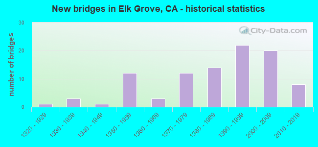
- New bridges - historical statistics
- 11920-1929
- 31930-1939
- 11940-1949
- 121950-1959
- 31960-1969
- 121970-1979
- 141980-1989
- 221990-1999
- 202000-2009
- 82010-2019

- Reconstructed bridges - Historical Statistics
- 11920-1929
- 01930-1939
- 01940-1949
- 01950-1959
- 01960-1969
- 01970-1979
- 71980-1989
- 51990-1999
- 52000-2009


- Bridge Condition - Deck
- 61.7%Good
- 8.5%Satisfactory
- 29.8%Fair

- Bridge Condition - Superstructure
- 72.2%Good
- 13.0%Satisfactory
- 14.8%Fair

- Bridge Condition - Substructure
- 87.0%Good
- 9.3%Satisfactory
- 3.7%Fair

- Bridge Condition - Channel
- 49.4%Excellent
- 16.9%Very good
- 13.0%Good
- 20.8%Satisfactory

- Bridge Condition - Culverts
- 50.0%Good
- 50.0%Satisfactory
Find on map >> Show street view
Structure Number: 24C0569, Location: 100' S OF CALVINE RD (Lat: 38.452411, Lng: -121.395864), Route carried "on" structure: City street , Year Built: 2004, Status: Open, Structure Length: 1.52m (4.99ft), Average Daily Traffic: 1,000 (year 2012), Truck Traffic: 1%, Average Future Daily Traffic: 1,650 (year 2037), Features Intersected: STRAWBERRY CREEK, Facility Carried by Structure: CLIFFCREST DR
Minimum Vertical Clearance: 30+ m (98+ ft), Kilometerpoint: 0.000, Lanes on structure: 4, Owner: City or Municipal Highway Agency, Approaching Roadway Width: 17.6m (57.7ft), Skew: 10 degrees, Material/Design: Concrete, Design/Construction: Arch - Deck, Number Of Spans In Main Unit: 1, Length of Maximum Span: 14.6m (47.9ft), Curb or Sidewalk Widths: Left: 0.4m (1.3ft), Right: 2.1m (6.9ft), Curb-To-Curb Width: 17.6m (57.7ft), Out-to-Out Width: 20.8m (68.2ft)
Condition: Superstructure: Good, Substructure: Good, Channel: Excellent, Operating Rating: 54.1 metric tons, Method Used To Determine Operating Rating: Field evaluation and documented engineering judgment, Inventory Rating: 32.4 metric tons, Method Used To Determine Inventory Rating: Field evaluation and documented engineering judgment, Structural Evaluation: Better than present minimum criteria, Deck Geometry: Somewhat better than minimum adequacy, Waterway Adequacy: Superior to present desirable criteria, Approach Roadway Alignment: Equal to present desirable criteria, Designated Inspection Frequency: Every 48 months, Inspection Date: April 2020
Find on map >> Show street view
Structure Number: 24C057, Location: 150' N OF APRICOT WOODS (Lat: 38.447350, Lng: -121.377336), Route carried "on" structure: City street , Year Built: 1997, Status: Open, Structure Length: 0.67m (2.20ft), Average Daily Traffic: 500 (year 2012), Truck Traffic: 1%, Average Future Daily Traffic: 820 (year 2037), Features Intersected: STRAWBERRY CREEK, Facility Carried by Structure: BLACK KITE DR
Minimum Vertical Clearance: 30+ m (98+ ft), Kilometerpoint: 0.000, Lanes on structure: 2, Owner: City or Municipal Highway Agency, Approaching Roadway Width: 14.0m (45.9ft), Skew: 2 degrees, Material/Design: Concrete continuous, Design/Construction: Culvert, Number Of Spans In Main Unit: 2, Length of Maximum Span: 3.2m (10.5ft)
Condition: Channel: Excellent, Culverts: Satisfactory, Operating Rating: 54.1 metric tons, Method Used To Determine Operating Rating: Field evaluation and documented engineering judgment, Inventory Rating: 32.4 metric tons, Method Used To Determine Inventory Rating: Field evaluation and documented engineering judgment, Structural Evaluation: Equal to present minimum criteria, Waterway Adequacy: Superior to present desirable criteria, Approach Roadway Alignment: Equal to present desirable criteria, Designated Inspection Frequency: Every 48 months, Inspection Date: April 2020
Find on map >> Show street view
Structure Number: 24C0571, Location: 0.6 MI NORTHEAST OF SR 99 (Lat: 38.380775, Lng: -121.354558), Route carried "on" structure: City street , Year Built: 2015, Status: Open, Structure Length: 7.80m (25.59ft), Average Daily Traffic: 19,260 (year 2014), Truck Traffic: 2%, Average Future Daily Traffic: 31,613 (year 2043), Design Load: HL 93, Features Intersected: UNION PACIFIC RAILROAD, Facility Carried by Structure: GRANT LINE RD
Minimum Vertical Clearance: 30+ m (98+ ft), Kilometerpoint: 0.000, Lanes on structure: 4, Owner: City or Municipal Highway Agency, Approaching Roadway Width: 19.7m (64.6ft), Skew: 32 degrees, Material/Design: Prestressed concrete continuous, Design/Construction: Box Beam or Girders - Multiple, Number Of Spans In Main Unit: 3, Length of Maximum Span: 36.5m (119.8ft), Curb or Sidewalk Widths: Left: 0.0m, Right: 3.1m (10.2ft), Curb-To-Curb Width: 19.7m (64.6ft), Out-to-Out Width: 24.5m (80.4ft)
Condition: Deck: Good, Superstructure: Good, Substructure: Good, Operating Rating: 42.1 metric tons, Method Used To Determine Operating Rating: Assigned ratings based on Load and Resistance Factor Design (LRFD) reported by rating factor (RF) using HL93 loadings, Inventory Rating: 32.4 metric tons, Method Used To Determine Inventory Rating: Assigned ratings based on Load and Resistance Factor Design (LRFD) reported by rating factor (RF) using HL93 loadings, Structural Evaluation: Better than present minimum criteria, Deck Geometry: Better than present minimum criteria, Underclear: Superior to present desirable criteria, Approach Roadway Alignment: Equal to present desirable criteria, Designated Inspection Frequency: Every 24 months, Inspection Date: April 2021, Deck Structure Type: Concrete Cast-file-Place
Find on map >> Show street view
Structure Number: 24C0579, Location: 0.1 MI SW OF LAGUNA SPR (Lat: 38.420183, Lng: -121.399753), Route carried "on" structure: City street , Year Built: 2012, Status: Open, Structure Length: 4.88m (16.01ft), Average Daily Traffic: 150 (year 2012), Truck Traffic: 2%, Average Future Daily Traffic: 356 (year 2036), Design Load: HL 93, Features Intersected: ELK GROVE CREEK, Facility Carried by Structure: LONGLEAF DRIVE
Minimum Vertical Clearance: 30+ m (98+ ft), Kilometerpoint: 0.000, Lanes on structure: 2, Owner: City or Municipal Highway Agency, Approaching Roadway Width: 13.0m (42.7ft), Skew: 1 degrees, Material/Design: Concrete continuous, Design/Construction: Slab, Number Of Spans In Main Unit: 4, Length of Maximum Span: 12.2m (40.0ft), Curb or Sidewalk Widths: Left: 2.0m (6.6ft), Right: 2.0m (6.6ft), Curb-To-Curb Width: 13.0m (42.7ft), Out-to-Out Width: 17.7m (58.1ft)
Condition: Deck: Good, Superstructure: Good, Substructure: Good, Channel: Very good, Operating Rating: 42.1 metric tons, Method Used To Determine Operating Rating: Assigned ratings based on Load and Resistance Factor Design (LRFD) reported by rating factor (RF) using HL93 loadings, Inventory Rating: 32.4 metric tons, Method Used To Determine Inventory Rating: Assigned ratings based on Load and Resistance Factor Design (LRFD) reported by rating factor (RF) using HL93 loadings, Structural Evaluation: Better than present minimum criteria, Deck Geometry: Superior to present desirable criteria, Waterway Adequacy: Equal to present desirable criteria, Approach Roadway Alignment: Equal to present desirable criteria, Designated Inspection Frequency: Every 48 months, Inspection Date: November 2018, Deck Structure Type: Concrete Cast-file-Place
Find on map >> Show street view
Structure Number: 24C0586, Location: 0.5 MI WEST OF BRADSHAW (Lat: 38.452531, Lng: -121.344414), Route carried "on" structure: City street , Year Built: 1996, Year Reconstructed: 2008, Status: Open, Structure Length: 2.36m (7.74ft), Average Daily Traffic: 16,480 (year 2014), Truck Traffic: 10%, Average Future Daily Traffic: 25,990 (year 2037), Design Load: HS 20+Mod, Features Intersected: LAGUNA CREEK, Facility Carried by Structure: CALVINE ROAD
Minimum Vertical Clearance: 30+ m (98+ ft), Kilometerpoint: 0.000, Lanes on structure: 5, Owner: City or Municipal Highway Agency, Approaching Roadway Width: 21.4m (70.2ft), Skew: 20 degrees, Material/Design: Concrete continuous, Design/Construction: Slab, Number Of Spans In Main Unit: 3, Length of Maximum Span: 7.6m (24.9ft), Curb or Sidewalk Widths: Left: 3.6m (11.8ft), Right: 1.8m (5.9ft), Curb-To-Curb Width: 25.0m (82.0ft), Out-to-Out Width: 35.3m (115.8ft)
Condition: Deck: Good, Superstructure: Good, Substructure: Good, Channel: Excellent, Operating Rating: 54.1 metric tons, Method Used To Determine Operating Rating: Assigned rating based on Load Factor Design (LFD) reported in metric tons, Inventory Rating: 32.4 metric tons, Method Used To Determine Inventory Rating: Assigned rating based on Load Factor Design (LFD) reported in metric tons, Structural Evaluation: Better than present minimum criteria, Deck Geometry: Superior to present desirable criteria, Waterway Adequacy: Superior to present desirable criteria, Approach Roadway Alignment: Equal to present desirable criteria, Designated Inspection Frequency: Every 48 months, Inspection Date: May 2019, Deck Structure Type: Concrete Cast-file-Place, Wearing Surface/Protective System: Wearing Surface: Bituminous
Find on map >> Show street view
Structure Number: 24C0605, Location: 0.4 MI N/O LAGUNA BLVD (Lat: 38.430394, Lng: -121.461864), Route carried "on" structure: City street , Year Built: 2013, Status: Open, Structure Length: 1.98m (6.50ft), Average Daily Traffic: 158 (year 2014), Average Future Daily Traffic: 300 (year 2035), Design Load: HL 93, Features Intersected: LAGUNA WEST CHANNEL, Facility Carried by Structure: DWIGHT ROAD
Minimum Vertical Clearance: 30+ m (98+ ft), Kilometerpoint: 0.000, Lanes on structure: 4, Owner: County Highway Agency, Approaching Roadway Width: 17.3m (56.8ft), Material/Design: Prestressed concrete, Design/Construction: Slab, Number Of Spans In Main Unit: 1, Length of Maximum Span: 19.1m (62.7ft), Curb or Sidewalk Widths: Left: 1.5m (4.9ft), Right: 1.5m (4.9ft), Curb-To-Curb Width: 17.3m (56.8ft), Out-to-Out Width: 21.0m (68.9ft)
Condition: Deck: Good, Superstructure: Good, Substructure: Good, Channel: Excellent, Operating Rating: 42.1 metric tons, Method Used To Determine Operating Rating: Assigned ratings based on Load and Resistance Factor Design (LRFD) reported by rating factor (RF) using HL93 loadings, Inventory Rating: 32.4 metric tons, Method Used To Determine Inventory Rating: Assigned ratings based on Load and Resistance Factor Design (LRFD) reported by rating factor (RF) using HL93 loadings, Structural Evaluation: Better than present minimum criteria, Deck Geometry: Somewhat better than minimum adequacy, Waterway Adequacy: Superior to present desirable criteria, Approach Roadway Alignment: Equal to present desirable criteria, Designated Inspection Frequency: Every 48 months, Inspection Date: October 2018, Deck Structure Type: Concrete Cast-file-Place
Find on map >> Show street view
Structure Number: 24 0048L, Location: 03-SAC-099-8.74 (Lat: 38.361150, Lng: -121.346711), Route carried "under" structure: State highway 99, Year Built: 1934, Structure Length: 0. m, Average Daily Traffic: 63,000 (year 2009), Truck Traffic: 18%, Features Intersected: STATE ROUTE 99 SB, Facility Carried by Structure: UP RR,BNSF,AMTRAK
Minimum Vertical Clearance: 4.39m (14.40ft), Kilometerpoint: 8.740, Lanes under structure: 4, Material/Design: Steel, Design/Construction: Girder and Floorbeam System, Length of Maximum Span: 30.8m (101.0ft)
Find on map >> Show street view
Structure Number: 24 0163, Location: 03-SAC-099-7.36 (Lat: 38.343417, Lng: -121.335914), Route carried "under" structure: State highway 99, Year Built: 1958, Structure Length: 0. m, Average Daily Traffic: 63,000 (year 2009), Truck Traffic: 18%, Features Intersected: STATE ROUTE 99, Facility Carried by Structure: DILLARD ROAD
Minimum Vertical Clearance: 4.72m (15.49ft), Kilometerpoint: 7.360, Lanes on structure: 2, Lanes under structure: 4, Material/Design: Prestressed concrete, Design/Construction: Tee Beam, Length of Maximum Span: 18.0m (59.1ft)
Find on map >> Show street view
Structure Number: 24 0358, Location: 03-SAC-099-13.66 (Lat: 38.423708, Lng: -121.395803), Route carried "under" structure: State highway 99, Year Built: 1990, Structure Length: 0. m, Average Daily Traffic: 62,000 (year 2009), Truck Traffic: 15%, Features Intersected: STATE ROUTE 99, Facility Carried by Structure: LAGUNA BLVD
Minimum Vertical Clearance: 5.02m (16.47ft), Kilometerpoint: 13.660, Lanes on structure: 7, Lanes under structure: 6, Material/Design: Prestressed concrete continuous, Design/Construction: Box Beam or Girders - Multiple, Length of Maximum Span: 36.2m (118.8ft)
Find on map >> Show street view
Structure Number: 24 0359, Location: 03-SAC-005-12.04 (Lat: 38.426283, Lng: -121.487792), Route carried "under" structure: Interstate 5, Year Built: 1992, Structure Length: 0. m, Average Daily Traffic: 93,000 (year 2010), Features Intersected: INTERSTATE 5, Facility Carried by Structure: LAGUNA BLVD
Minimum Vertical Clearance: 5.23m (17.16ft), Kilometerpoint: 12.040, Lanes on structure: 3, Lanes under structure: 6, Material/Design: Concrete continuous, Design/Construction: Box Beam or Girders - Multiple, Length of Maximum Span: 45.1m (148.0ft)
Find on map >> Show street view
Structure Number: 24 0361, Location: 03-SAC-099-12.76 (Lat: 38.408972, Lng: -121.388975), Route carried "under" structure: State highway 99, Year Built: 1997, Structure Length: 0. m, Average Daily Traffic: 62,000 (year 2009), Truck Traffic: 15%, Features Intersected: STATE ROUTE 99, Facility Carried by Structure: ELK GROVE BLVD
Minimum Vertical Clearance: 5.28m (17.32ft), Kilometerpoint: 12.760, Lanes on structure: 7, Lanes under structure: 6, Material/Design: Prestressed concrete continuous, Design/Construction: Box Beam or Girders - Multiple, Length of Maximum Span: 34.6m (113.5ft)
Find on map >> Show street view
Structure Number: 24 0367, Location: 03-SAC-099-10.07-ELKG (Lat: 38.376097, Lng: -121.362250), Route carried "under" structure: State highway 99, Year Built: 2009, Structure Length: 0. m, Average Daily Traffic: 62,000 (year 2009), Truck Traffic: 15%, Features Intersected: STATE ROUTE 99, Facility Carried by Structure: GRANT LINE ROAD
Minimum Vertical Clearance: 5.60m (18.37ft), Kilometerpoint: 10.070, Lanes on structure: 7, Lanes under structure: 4, Material/Design: Prestressed concrete continuous, Design/Construction: Box Beam or Girders - Multiple, Length of Maximum Span: 41.5m (136.2ft)
Find on map >> Show street view
Structure Number: 24 0374, Location: 03-SAC-099-14.87-ELKG (Lat: 38.437633, Lng: -121.402164), Route carried "under" structure: State highway 99, Year Built: 2010, Structure Length: 0. m, Average Daily Traffic: 145,000 (year 2010), Truck Traffic: 16%, Features Intersected: STATE ROUTE 99, Facility Carried by Structure: SHELDON ROAD
Minimum Vertical Clearance: 5.81m (19.06ft), Kilometerpoint: 14.870, Lanes on structure: 9, Lanes under structure: 9, Material/Design: Prestressed concrete continuous, Design/Construction: Box Beam or Girders - Multiple, Length of Maximum Span: 43.5m (142.7ft)
Find on map >> Show street view
Structure Number: 24 0384, Location: 03-SAC-099-13.01-ELKG (Lat: 38.412550, Lng: -121.390297), Route carried "under" structure: State highway 99, Year Built: 2014, Structure Length: 0. m, Average Daily Traffic: 62,000 (year 2009), Truck Traffic: 15%, Features Intersected: STATE ROUTE 99, Facility Carried by Structure: ELKGROVE CRK TRAIL
Minimum Vertical Clearance: 5.58m (18.31ft), Kilometerpoint: 13.010, Lanes under structure: 8, Material/Design: Concrete continuous, Design/Construction: Box Beam or Girders - Single/Spread, Length of Maximum Span: 45.9m (150.6ft)