Bridge Statistics for Edna, Texas (TX)
Condition, Traffic, Stress, Structural Evaluation, Project Costs
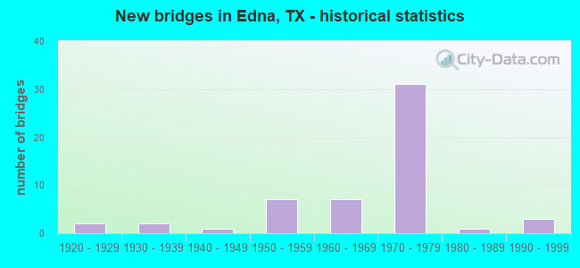
- New bridges - historical statistics
- 21920-1929
- 21930-1939
- 11940-1949
- 71950-1959
- 71960-1969
- 311970-1979
- 11980-1989
- 31990-1999

- Reconstructed bridges - Historical Statistics
- 11940-1949
- 11950-1959
- 21960-1969
- 01970-1979
- 31980-1989
- 11990-1999
- 22000-2009
- 12010-2019


- Bridge Condition - Deck
- 50.0%Good
- 42.3%Satisfactory
- 3.8%Fair
- 3.8%Poor

- Bridge Condition - Superstructure
- 3.8%Very good
- 42.3%Good
- 42.3%Satisfactory
- 7.7%Fair
- 3.8%Serious

- Bridge Condition - Substructure
- 30.8%Good
- 61.5%Satisfactory
- 7.7%Fair

- Bridge Condition - Channel
- 7.7%Very good
- 65.4%Good
- 23.1%Satisfactory
- 3.8%Fair

- Bridge Condition - Culverts
- 50.0%Good
- 50.0%Satisfactory
Find on map >> Show street view
Structure Number: 131210008903009, Location: 2.90 MI SW OF FM 822 (Lat: 28.957958, Lng: -96.694831), Route carried "on" structure: US 59, Year Built: 1930, Year Reconstructed: 1972, Status: Open, Structure Length: 9.69m (31.79ft), Average Daily Traffic: 11,965 (year 2020), Truck Traffic: 17%, Average Future Daily Traffic: 16,820 (year 2038), Design Load: H 15, Features Intersected: LAVACA RIVER WEST RELIEF
Minimum Vertical Clearance: 30+ m (98+ ft), Kilometerpoint: 22.267, Lanes on structure: 2, Base Highway Network: Yes, Owner: State Highway Agency, Approaching Roadway Width: 12.2m (40.0ft), Material/Design: Concrete, Design/Construction: Tee Beam, Number Of Spans In Main Unit: 12, Length of Maximum Span: 8.2m (26.9ft), Curb-To-Curb Width: 12.8m (42.0ft), Out-to-Out Width: 13.5m (44.3ft)
Condition: Deck: Good, Superstructure: Good, Substructure: Good, Channel: Good, Operating Rating: 60.8 metric tons, Method Used To Determine Operating Rating: Load Factor (LF), Inventory Rating: 36.3 metric tons, Method Used To Determine Inventory Rating: Load Factor (LF), Structural Evaluation: Better than present minimum criteria, Deck Geometry: Equal to present desirable criteria, Waterway Adequacy: Equal to present minimum criteria, Approach Roadway Alignment: Equal to present desirable criteria, Designated Inspection Frequency: Every 24 months, Inspection Date: April 2021, Deck Structure Type: Concrete Cast-file-Place, Wearing Surface/Protective System: Wearing Surface: Bituminous
Find on map >> Show street view
Structure Number: 13121000890301, Location: 2.40 MI SW OF FM 822 (Lat: 28.959833, Lng: -96.686925), Route carried "on" structure: US 59, Year Built: 1930, Year Reconstructed: 1988, Status: Open, Structure Length: 34.05m (111.71ft), Average Daily Traffic: 11,965 (year 2020), Truck Traffic: 17%, Average Future Daily Traffic: 16,820 (year 2038), Features Intersected: LAVACA RIVER
Minimum Vertical Clearance: 30+ m (98+ ft), Kilometerpoint: 21.330, Lanes on structure: 2, Base Highway Network: Yes, Owner: State Highway Agency, Approaching Roadway Width: 13.4m (44.0ft), Material/Design: Prestressed concrete, Design/Construction: Box Beam or Girders - Multiple, Number Of Spans In Main Unit: 2, Number Of Approach Spans: 37, Length of Maximum Span: 30.5m (100.1ft), Curb-To-Curb Width: 11.3m (37.1ft), Out-to-Out Width: 12.2m (40.0ft)
Condition: Deck: Satisfactory, Superstructure: Fair, Substructure: Fair, Channel: Satisfactory, Operating Rating: 48.1 metric tons, Method Used To Determine Operating Rating: Load Factor (LF), Inventory Rating: 29.0 metric tons, Method Used To Determine Inventory Rating: Load Factor (LF), Structural Evaluation: Somewhat better than minimum adequacy, Deck Geometry: Equal to present minimum criteria, Waterway Adequacy: Superior to present desirable criteria, Approach Roadway Alignment: Equal to present desirable criteria, Designated Inspection Frequency: Every 24 months, Inspection Date: April 2021, Deck Structure Type: Concrete Cast-file-Place, Wearing Surface/Protective System: Wearing Surface: Bituminous
Find on map >> Show street view
Structure Number: 131210008903059, Location: 2.40 MI SW OF FM 822 (Lat: 28.960119, Lng: -96.686961), Route carried "on" structure: US 59, Year Built: 1956, Year Reconstructed: 1993, Status: Open, Structure Length: 34.41m (112.89ft), Average Daily Traffic: 10,797 (year 2020), Truck Traffic: 17%, Average Future Daily Traffic: 16,820 (year 2038), Features Intersected: LAVACA RIVER
Minimum Vertical Clearance: 30+ m (98+ ft), Kilometerpoint: 21.330, Lanes on structure: 2, Base Highway Network: Yes, Owner: State Highway Agency, Approaching Roadway Width: 12.2m (40.0ft), Material/Design: Steel continuous, Design/Construction: Stringer/Multi-beam, Number Of Spans In Main Unit: 3, Number Of Approach Spans: 28, Length of Maximum Span: 33.5m (109.9ft), Curb-To-Curb Width: 11.2m (36.7ft), Out-to-Out Width: 12.2m (40.0ft)
Condition: Deck: Good, Superstructure: Satisfactory, Substructure: Satisfactory, Channel: Satisfactory, Operating Rating: 39.0 metric tons, Method Used To Determine Operating Rating: Load Factor (LF), Inventory Rating: 23.6 metric tons, Method Used To Determine Inventory Rating: Load Factor (LF), Structural Evaluation: Somewhat better than minimum adequacy, Deck Geometry: Equal to present minimum criteria, Waterway Adequacy: Superior to present desirable criteria, Approach Roadway Alignment: Equal to present desirable criteria, Designated Inspection Frequency: Every 24 months, Inspection Date: April 2021, Deck Structure Type: Concrete Cast-file-Place, Wearing Surface/Protective System: Wearing Surface: Bituminous
Find on map >> Show street view
Structure Number: 13121000890306, Location: 2.90 MI SW OF FM 822 (Lat: 28.958117, Lng: -96.694939), Route carried "on" structure: US 59, Year Built: 1956, Year Reconstructed: 1993, Status: Open, Structure Length: 11.09m (36.38ft), Average Daily Traffic: 10,797 (year 2020), Truck Traffic: 17%, Average Future Daily Traffic: 16,820 (year 2038), Features Intersected: LAVACA RIVER WEST RELIEF
Minimum Vertical Clearance: 30+ m (98+ ft), Kilometerpoint: 22.275, Lanes on structure: 2, Base Highway Network: Yes, Owner: State Highway Agency, Approaching Roadway Width: 12.2m (40.0ft), Material/Design: Concrete, Design/Construction: Stringer/Multi-beam, Number Of Spans In Main Unit: 12, Length of Maximum Span: 9.1m (29.9ft), Curb-To-Curb Width: 11.2m (36.7ft), Out-to-Out Width: 12.2m (40.0ft)
Condition: Deck: Good, Superstructure: Satisfactory, Substructure: Satisfactory, Channel: Good, Operating Rating: 68.0 metric tons, Method Used To Determine Operating Rating: Load Factor (LF), Inventory Rating: 40.8 metric tons, Method Used To Determine Inventory Rating: Load Factor (LF), Structural Evaluation: Equal to present minimum criteria, Deck Geometry: Equal to present minimum criteria, Waterway Adequacy: Superior to present desirable criteria, Approach Roadway Alignment: Equal to present desirable criteria, Designated Inspection Frequency: Every 24 months, Inspection Date: April 2021, Deck Structure Type: Concrete Cast-file-Place, Wearing Surface/Protective System: Wearing Surface: Bituminous
Find on map >> Show street view
Structure Number: 131210008903076, Location: 4.50 MI SW OF SH 111 (Lat: 28.949822, Lng: -96.707025), Route carried "on" structure: US 59, Year Built: 1968, Status: Open, Structure Length: 5.64m (18.50ft), Average Daily Traffic: 12,529 (year 2020), Truck Traffic: 17%, Average Future Daily Traffic: 16,820 (year 2038), Design Load: HS 20, Features Intersected: FM 234
Minimum Vertical Clearance: 30+ m (98+ ft), Kilometerpoint: 23.783, Lanes on structure: 2, Lanes under structure: 2, Owner: State Highway Agency, Approaching Roadway Width: 12.2m (40.0ft), Material/Design: Prestressed concrete, Design/Construction: Stringer/Multi-beam, Number Of Spans In Main Unit: 1, Number Of Approach Spans: 2, Length of Maximum Span: 22.9m (75.1ft), Curb-To-Curb Width: 12.1m (39.7ft), Out-to-Out Width: 12.9m (42.3ft)
Condition: Deck: Good, Superstructure: Satisfactory, Substructure: Satisfactory, Operating Rating: 54.4 metric tons, Method Used To Determine Operating Rating: Assigned rating based on Load Factor Design (LFD) reported in metric tons, Inventory Rating: 32.7 metric tons, Method Used To Determine Inventory Rating: Assigned rating based on Load Factor Design (LFD) reported in metric tons, Structural Evaluation: Equal to present minimum criteria, Deck Geometry: Better than present minimum criteria, Underclear: Better than present minimum criteria, Approach Roadway Alignment: Equal to present desirable criteria, Designated Inspection Frequency: Every 24 months, Inspection Date: April 2021, Deck Structure Type: Concrete Cast-file-Place, Wearing Surface/Protective System: Wearing Surface: Bituminous
Find on map >> Show street view
Structure Number: 131210008903077, Location: 4.50 MI SW OF SH 111 (Lat: 28.949419, Lng: -96.706614), Route carried "on" structure: US 59, Year Built: 1968, Status: Open, Structure Length: 5.64m (18.50ft), Average Daily Traffic: 12,012 (year 2020), Truck Traffic: 17%, Average Future Daily Traffic: 16,820 (year 2038), Design Load: HS 20, Features Intersected: FM 234
Minimum Vertical Clearance: 30+ m (98+ ft), Kilometerpoint: 23.788, Lanes on structure: 2, Lanes under structure: 2, Owner: State Highway Agency, Approaching Roadway Width: 12.2m (40.0ft), Material/Design: Prestressed concrete, Design/Construction: Stringer/Multi-beam, Number Of Spans In Main Unit: 1, Number Of Approach Spans: 2, Length of Maximum Span: 22.9m (75.1ft), Curb-To-Curb Width: 12.1m (39.7ft), Out-to-Out Width: 12.9m (42.3ft)
Condition: Deck: Good, Superstructure: Good, Substructure: Satisfactory, Operating Rating: 54.4 metric tons, Method Used To Determine Operating Rating: Assigned rating based on Load Factor Design (LFD) reported in metric tons, Inventory Rating: 32.7 metric tons, Method Used To Determine Inventory Rating: Assigned rating based on Load Factor Design (LFD) reported in metric tons, Structural Evaluation: Equal to present minimum criteria, Deck Geometry: Better than present minimum criteria, Underclear: Better than present minimum criteria, Approach Roadway Alignment: Equal to present desirable criteria, Designated Inspection Frequency: Every 24 months, Inspection Date: April 2021, Deck Structure Type: Concrete Cast-file-Place, Wearing Surface/Protective System: Wearing Surface: Bituminous
Find on map >> Show street view
Structure Number: 131210008903104, Location: 1.51 MI S of FM 822 (Lat: 28.966597, Lng: -96.673258), Route carried "on" structure: Ramp US 59, Year Built: 1972, Status: Open, Structure Length: 0.85m (2.79ft), Average Daily Traffic: 50 (year 2013), Truck Traffic: 18%, Average Future Daily Traffic: 70 (year 2033), Design Load: HS 20, Features Intersected: Drain
Minimum Vertical Clearance: 30+ m (98+ ft), Kilometerpoint: 19.900, Lanes on structure: 1, Owner: State Highway Agency, Approaching Roadway Width: 7.9m (25.9ft), Material/Design: Concrete, Design/Construction: Culvert, Number Of Spans In Main Unit: 5, Length of Maximum Span: 1.5m (4.9ft), Curb-To-Curb Width: 7.9m (25.9ft), Out-to-Out Width: 13.2m (43.3ft)
Condition: Channel: Good, Culverts: Good, Operating Rating: 39.9 metric tons, Method Used To Determine Operating Rating: Load Factor (LF), Inventory Rating: 23.6 metric tons, Method Used To Determine Inventory Rating: Load Factor (LF), Structural Evaluation: Equal to present minimum criteria, Deck Geometry: Equal to present desirable criteria, Waterway Adequacy: Equal to present minimum criteria, Approach Roadway Alignment: Equal to present desirable criteria, Designated Inspection Frequency: Every 24 months, Inspection Date: May 2021, Deck Structure Type: Concrete Cast-file-Place, Wearing Surface/Protective System: Wearing Surface: Bituminous
Find on map >> Show street view
Structure Number: 131210008903105, Location: 1.51 MI S of FM 822 (Lat: 28.966350, Lng: -96.672847), Route carried "on" structure: US 59, Year Built: 1972, Status: Open, Structure Length: 0.67m (2.20ft), Average Daily Traffic: 22,761 (year 2020), Truck Traffic: 18%, Average Future Daily Traffic: 28,380 (year 2033), Design Load: HS 20, Features Intersected: Drain
Minimum Vertical Clearance: 30+ m (98+ ft), Kilometerpoint: 19.901, Lanes on structure: 4, Base Highway Network: Yes, Owner: State Highway Agency, Approaching Roadway Width: 24.4m (80.1ft), Skew: 20 degrees, Material/Design: Concrete, Design/Construction: Culvert, Number Of Spans In Main Unit: 4, Length of Maximum Span: 1.5m (4.9ft)
Condition: Channel: Good, Culverts: Good, Operating Rating: 39.9 metric tons, Method Used To Determine Operating Rating: Load Factor (LF), Inventory Rating: 23.6 metric tons, Method Used To Determine Inventory Rating: Load Factor (LF), Structural Evaluation: Somewhat better than minimum adequacy, Waterway Adequacy: Equal to present minimum criteria, Approach Roadway Alignment: Equal to present desirable criteria, Designated Inspection Frequency: Every 24 months, Inspection Date: May 2021
Find on map >> Show street view
Structure Number: 131210008903106, Location: 1.25 MI S OF FM 822 (Lat: 28.969378, Lng: -96.670772), Route carried "on" structure: US 59, Year Built: 1972, Status: Open, Structure Length: 6.40m (21.00ft), Average Daily Traffic: 10,797 (year 2020), Truck Traffic: 18%, Average Future Daily Traffic: 14,190 (year 2038), Design Load: HS 20, Features Intersected: BU 59
Minimum Vertical Clearance: 30+ m (98+ ft), Kilometerpoint: 19.473, Lanes on structure: 2, Lanes under structure: 2, Base Highway Network: Yes, Owner: State Highway Agency, Approaching Roadway Width: 12.8m (42.0ft), Material/Design: Prestressed concrete, Design/Construction: Stringer/Multi-beam, Number Of Spans In Main Unit: 1, Number Of Approach Spans: 2, Length of Maximum Span: 27.4m (89.9ft), Curb-To-Curb Width: 13.0m (42.7ft), Out-to-Out Width: 13.5m (44.3ft)
Condition: Deck: Good, Superstructure: Satisfactory, Substructure: Satisfactory, Operating Rating: 68.0 metric tons, Method Used To Determine Operating Rating: Load Factor (LF), Inventory Rating: 33.6 metric tons, Method Used To Determine Inventory Rating: Load Factor (LF), Structural Evaluation: Equal to present minimum criteria, Deck Geometry: Superior to present desirable criteria, Underclear: Equal to present minimum criteria, Approach Roadway Alignment: Equal to present desirable criteria, Designated Inspection Frequency: Every 24 months, Inspection Date: April 2021, Deck Structure Type: Concrete Cast-file-Place, Wearing Surface/Protective System: Wearing Surface: Bituminous
Find on map >> Show street view
Structure Number: 131210008903107, Location: 1.25 MI S OF FM 822 (Lat: 28.969267, Lng: -96.670583), Route carried "on" structure: US 59, Year Built: 1972, Status: Open, Structure Length: 6.40m (21.00ft), Average Daily Traffic: 11,965 (year 2020), Truck Traffic: 18%, Average Future Daily Traffic: 14,190 (year 2038), Design Load: HS 20, Features Intersected: BU 59
Minimum Vertical Clearance: 30+ m (98+ ft), Kilometerpoint: 19.473, Lanes on structure: 2, Lanes under structure: 2, Base Highway Network: Yes, Owner: State Highway Agency, Approaching Roadway Width: 12.8m (42.0ft), Material/Design: Prestressed concrete, Design/Construction: Stringer/Multi-beam, Number Of Spans In Main Unit: 1, Number Of Approach Spans: 2, Length of Maximum Span: 27.4m (89.9ft), Curb-To-Curb Width: 13.0m (42.7ft), Out-to-Out Width: 13.5m (44.3ft)
Condition: Deck: Good, Superstructure: Satisfactory, Substructure: Satisfactory, Operating Rating: 68.0 metric tons, Method Used To Determine Operating Rating: Load Factor (LF), Inventory Rating: 30.8 metric tons, Method Used To Determine Inventory Rating: Load Factor (LF), Structural Evaluation: Equal to present minimum criteria, Deck Geometry: Superior to present desirable criteria, Underclear: Equal to present minimum criteria, Approach Roadway Alignment: Equal to present desirable criteria, Designated Inspection Frequency: Every 24 months, Inspection Date: April 2021, Deck Structure Type: Concrete Cast-file-Place, Wearing Surface/Protective System: Wearing Surface: Bituminous
Find on map >> Show street view
Structure Number: 131210008903108, Location: 0.40 MI S of FM 822 (Lat: 28.980256, Lng: -96.663617), Route carried "on" structure: ServiceUS 59, Year Built: 1972, Status: Open, Structure Length: 1.71m (5.61ft), Average Daily Traffic: 510 (year 2013), Truck Traffic: 18%, Average Future Daily Traffic: 720 (year 2033), Design Load: HS 20, Features Intersected: Dry Creek
Minimum Vertical Clearance: 30+ m (98+ ft), Kilometerpoint: 18.110, Lanes on structure: 2, Owner: State Highway Agency, Approaching Roadway Width: 7.3m (24.0ft), Skew: 1 degrees, Material/Design: Concrete, Design/Construction: Culvert, Number Of Spans In Main Unit: 5, Length of Maximum Span: 3.0m (9.8ft), Curb-To-Curb Width: 7.3m (24.0ft), Out-to-Out Width: 17.1m (56.1ft)
Condition: Channel: Good, Culverts: Good, Operating Rating: 39.9 metric tons, Method Used To Determine Operating Rating: Load Factor (LF), Inventory Rating: 23.6 metric tons, Method Used To Determine Inventory Rating: Load Factor (LF), Structural Evaluation: Equal to present minimum criteria, Deck Geometry: Meets minimum limits, Waterway Adequacy: Equal to present minimum criteria, Approach Roadway Alignment: Equal to present desirable criteria, Designated Inspection Frequency: Every 24 months, Inspection Date: May 2021, Deck Structure Type: Concrete Cast-file-Place, Wearing Surface/Protective System: Wearing Surface: Bituminous
Find on map >> Show street view
Structure Number: 131210008903109, Location: 0.40 MI S of FM 822 (Lat: 28.979914, Lng: -96.663289), Route carried "on" structure: US 59, Year Built: 1972, Status: Open, Structure Length: 1.71m (5.61ft), Average Daily Traffic: 21,601 (year 2020), Truck Traffic: 18%, Average Future Daily Traffic: 28,380 (year 2033), Design Load: HS 20, Features Intersected: Dry Creek
Minimum Vertical Clearance: 30+ m (98+ ft), Kilometerpoint: 18.110, Lanes on structure: 6, Base Highway Network: Yes, Owner: State Highway Agency, Approaching Roadway Width: 34.1m (111.9ft), Skew: 21 degrees, Material/Design: Concrete, Design/Construction: Culvert, Number Of Spans In Main Unit: 5, Length of Maximum Span: 3.0m (9.8ft)
Condition: Channel: Good, Culverts: Satisfactory, Operating Rating: 39.9 metric tons, Method Used To Determine Operating Rating: Load Factor (LF), Inventory Rating: 23.6 metric tons, Method Used To Determine Inventory Rating: Load Factor (LF), Structural Evaluation: Somewhat better than minimum adequacy, Waterway Adequacy: Equal to present minimum criteria, Approach Roadway Alignment: Equal to present desirable criteria, Designated Inspection Frequency: Every 24 months, Inspection Date: May 2021, Deck Structure Type: Concrete Cast-file-Place, Wearing Surface/Protective System: Wearing Surface: Bituminous
Find on map >> Show street view
Structure Number: 13121000890311, Location: 0.50 MI SW OF SH 111 (Lat: 28.983561, Lng: -96.657953), Route carried "on" structure: US 59, Year Built: 1972, Status: Open, Structure Length: 6.25m (20.51ft), Average Daily Traffic: 10,478 (year 2020), Truck Traffic: 18%, Average Future Daily Traffic: 14,190 (year 2038), Design Load: HS 20, Features Intersected: FM 822
Minimum Vertical Clearance: 30+ m (98+ ft), Kilometerpoint: 17.420, Lanes on structure: 2, Lanes under structure: 2, Owner: State Highway Agency, Approaching Roadway Width: 12.8m (42.0ft), Material/Design: Prestressed concrete, Design/Construction: Stringer/Multi-beam, Number Of Spans In Main Unit: 1, Number Of Approach Spans: 2, Length of Maximum Span: 32.0m (105.0ft), Curb-To-Curb Width: 12.9m (42.3ft), Out-to-Out Width: 13.5m (44.3ft)
Condition: Deck: Good, Superstructure: Good, Substructure: Satisfactory, Operating Rating: 66.2 metric tons, Method Used To Determine Operating Rating: Load Factor (LF), Inventory Rating: 17.2 metric tons, Method Used To Determine Inventory Rating: Load Factor (LF), Structural Evaluation: Meets minimum limits, Deck Geometry: Superior to present desirable criteria, Underclear: Equal to present minimum criteria, Approach Roadway Alignment: Equal to present desirable criteria, Designated Inspection Frequency: Every 24 months, Inspection Date: April 2021, Deck Structure Type: Concrete Cast-file-Place, Wearing Surface/Protective System: Wearing Surface: Bituminous
Find on map >> Show street view
Structure Number: 131210008903111, Location: 0.50 MI SW OF SH 111 (Lat: 28.983256, Lng: -96.657747), Route carried "on" structure: US 59, Year Built: 1972, Status: Open, Structure Length: 6.25m (20.51ft), Average Daily Traffic: 11,123 (year 2020), Truck Traffic: 18%, Average Future Daily Traffic: 14,190 (year 2035), Design Load: HS 20, Features Intersected: FM 822
Minimum Vertical Clearance: 30+ m (98+ ft), Kilometerpoint: 17.434, Lanes on structure: 2, Lanes under structure: 2, Owner: State Highway Agency, Approaching Roadway Width: 12.8m (42.0ft), Material/Design: Prestressed concrete, Design/Construction: Stringer/Multi-beam, Number Of Spans In Main Unit: 1, Number Of Approach Spans: 2, Length of Maximum Span: 32.0m (105.0ft), Curb-To-Curb Width: 12.9m (42.3ft), Out-to-Out Width: 13.5m (44.3ft)
Condition: Deck: Satisfactory, Superstructure: Good, Substructure: Satisfactory, Operating Rating: 66.2 metric tons, Method Used To Determine Operating Rating: Load Factor (LF), Inventory Rating: 17.2 metric tons, Method Used To Determine Inventory Rating: Load Factor (LF), Structural Evaluation: Meets minimum limits, Deck Geometry: Superior to present desirable criteria, Underclear: Better than present minimum criteria, Approach Roadway Alignment: Equal to present desirable criteria, Designated Inspection Frequency: Every 24 months, Inspection Date: April 2021, Deck Structure Type: Concrete Cast-file-Place, Wearing Surface/Protective System: Wearing Surface: Bituminous
Find on map >> Show street view
Structure Number: 131210008903112, Location: 0.09 MI S OF SH 111 (Lat: 28.985931, Lng: -96.652444), Route carried "on" structure: US 59, Year Built: 1972, Status: Open, Structure Length: 7.92m (25.98ft), Average Daily Traffic: 11,265 (year 2020), Truck Traffic: 18%, Average Future Daily Traffic: 14,190 (year 2038), Design Load: HS 20, Features Intersected: NORTH EAST ST
Minimum Vertical Clearance: 30+ m (98+ ft), Kilometerpoint: 16.835, Lanes on structure: 2, Lanes under structure: 2, Owner: State Highway Agency, Approaching Roadway Width: 12.8m (42.0ft), Skew: 1 degrees, Material/Design: Prestressed concrete, Design/Construction: Stringer/Multi-beam, Number Of Spans In Main Unit: 1, Number Of Approach Spans: 3, Length of Maximum Span: 32.0m (105.0ft), Curb-To-Curb Width: 12.9m (42.3ft), Out-to-Out Width: 13.5m (44.3ft)
Condition: Deck: Good, Superstructure: Very good, Substructure: Good, Operating Rating: 54.4 metric tons, Method Used To Determine Operating Rating: Assigned rating based on Load Factor Design (LFD) reported in metric tons, Inventory Rating: 32.7 metric tons, Method Used To Determine Inventory Rating: Assigned rating based on Load Factor Design (LFD) reported in metric tons, Structural Evaluation: Better than present minimum criteria, Deck Geometry: Superior to present desirable criteria, Underclear: Superior to present desirable criteria, Approach Roadway Alignment: Equal to present desirable criteria, Designated Inspection Frequency: Every 24 months, Inspection Date: April 2021, Deck Structure Type: Concrete Cast-file-Place, Wearing Surface/Protective System: Wearing Surface: Bituminous
Find on map >> Show street view
Structure Number: 131210008903113, Location: 0.09 MI S OF SH 111 (Lat: 28.985661, Lng: -96.652300), Route carried "on" structure: US 59, Year Built: 1972, Status: Open, Structure Length: 7.92m (25.98ft), Average Daily Traffic: 11,128 (year 2020), Truck Traffic: 18%, Average Future Daily Traffic: 14,190 (year 2035), Design Load: HS 20, Features Intersected: NORTH EAST ST
Minimum Vertical Clearance: 30+ m (98+ ft), Kilometerpoint: 16.826, Lanes on structure: 2, Lanes under structure: 2, Owner: State Highway Agency, Approaching Roadway Width: 12.8m (42.0ft), Skew: 1 degrees, Material/Design: Prestressed concrete, Design/Construction: Stringer/Multi-beam, Number Of Spans In Main Unit: 1, Number Of Approach Spans: 3, Length of Maximum Span: 32.0m (105.0ft), Curb-To-Curb Width: 12.9m (42.3ft), Out-to-Out Width: 13.5m (44.3ft)
Condition: Deck: Good, Superstructure: Good, Substructure: Good, Operating Rating: 54.4 metric tons, Method Used To Determine Operating Rating: Assigned rating based on Load Factor Design (LFD) reported in metric tons, Inventory Rating: 32.7 metric tons, Method Used To Determine Inventory Rating: Assigned rating based on Load Factor Design (LFD) reported in metric tons, Structural Evaluation: Better than present minimum criteria, Deck Geometry: Superior to present desirable criteria, Underclear: Superior to present desirable criteria, Approach Roadway Alignment: Equal to present desirable criteria, Designated Inspection Frequency: Every 24 months, Inspection Date: April 2021, Deck Structure Type: Concrete Cast-file-Place, Wearing Surface/Protective System: Wearing Surface: Bituminous
Find on map >> Show street view
Structure Number: 131210008903114, Location: 3.5 MI W OF FM 530 (Lat: 28.986669, Lng: -96.650694), Route carried "on" structure: US 59, Year Built: 1972, Status: Open, Structure Length: 7.92m (25.98ft), Average Daily Traffic: 11,265 (year 2020), Truck Traffic: 17%, Average Future Daily Traffic: 16,330 (year 2038), Design Load: HS 20, Features Intersected: SH 111
Minimum Vertical Clearance: 30+ m (98+ ft), Kilometerpoint: 16.637, Lanes on structure: 2, Lanes under structure: 5, Owner: State Highway Agency, Approaching Roadway Width: 12.8m (42.0ft), Skew: 1 degrees, Material/Design: Prestressed concrete, Design/Construction: Stringer/Multi-beam, Number Of Spans In Main Unit: 1, Number Of Approach Spans: 3, Length of Maximum Span: 32.0m (105.0ft), Curb-To-Curb Width: 12.9m (42.3ft), Out-to-Out Width: 13.5m (44.3ft)
Condition: Deck: Satisfactory, Superstructure: Satisfactory, Substructure: Satisfactory, Operating Rating: 54.4 metric tons, Method Used To Determine Operating Rating: Assigned rating based on Load Factor Design (LFD) reported in metric tons, Inventory Rating: 32.7 metric tons, Method Used To Determine Inventory Rating: Assigned rating based on Load Factor Design (LFD) reported in metric tons, Structural Evaluation: Equal to present minimum criteria, Deck Geometry: Superior to present desirable criteria, Underclear: Equal to present minimum criteria, Approach Roadway Alignment: Equal to present desirable criteria, Designated Inspection Frequency: Every 24 months, Inspection Date: April 2021, Deck Structure Type: Concrete Cast-file-Place, Wearing Surface/Protective System: Wearing Surface: Bituminous
Find on map >> Show street view
Structure Number: 131210008903115, Location: 3.5 MI W OF FM 530 (Lat: 28.986417, Lng: -96.650631), Route carried "on" structure: US 59, Year Built: 1972, Status: Open, Structure Length: 7.92m (25.98ft), Average Daily Traffic: 11,128 (year 2020), Truck Traffic: 17%, Average Future Daily Traffic: 16,330 (year 2038), Design Load: HS 20, Features Intersected: SH 111
Minimum Vertical Clearance: 30+ m (98+ ft), Kilometerpoint: 16.637, Lanes on structure: 2, Lanes under structure: 5, Owner: State Highway Agency, Approaching Roadway Width: 12.8m (42.0ft), Skew: 1 degrees, Material/Design: Prestressed concrete, Design/Construction: Stringer/Multi-beam, Number Of Spans In Main Unit: 1, Number Of Approach Spans: 3, Length of Maximum Span: 32.0m (105.0ft), Curb-To-Curb Width: 12.9m (42.3ft), Out-to-Out Width: 13.5m (44.3ft)
Condition: Deck: Satisfactory, Superstructure: Good, Substructure: Good, Operating Rating: 54.4 metric tons, Method Used To Determine Operating Rating: Assigned rating based on Load Factor Design (LFD) reported in metric tons, Inventory Rating: 32.7 metric tons, Method Used To Determine Inventory Rating: Assigned rating based on Load Factor Design (LFD) reported in metric tons, Structural Evaluation: Better than present minimum criteria, Deck Geometry: Superior to present desirable criteria, Underclear: Equal to present minimum criteria, Approach Roadway Alignment: Equal to present desirable criteria, Designated Inspection Frequency: Every 24 months, Inspection Date: April 2021, Deck Structure Type: Concrete Cast-file-Place, Wearing Surface/Protective System: Wearing Surface: Bituminous
Find on map >> Show street view
Structure Number: 131210008904118, Location: 1.00 MI W of LP 521 (Lat: 28.990028, Lng: -96.642139), Route carried "on" structure: US 59, Year Built: 1972, Year Reconstructed: 2006, Status: Open, Structure Length: 0.98m (3.22ft), Average Daily Traffic: 22,393 (year 2020), Truck Traffic: 17%, Average Future Daily Traffic: 32,670 (year 2033), Design Load: HS 20, Features Intersected: Post Oak Branch
Minimum Vertical Clearance: 30+ m (98+ ft), Kilometerpoint: 23.556, Lanes on structure: 8, Base Highway Network: Yes, Owner: State Highway Agency, Approaching Roadway Width: 37.8m (124.0ft), Skew: 23 degrees, Material/Design: Concrete, Design/Construction: Culvert, Number Of Spans In Main Unit: 3, Length of Maximum Span: 2.4m (7.9ft)
Condition: Channel: Good, Culverts: Good, Operating Rating: 39.9 metric tons, Method Used To Determine Operating Rating: Load Factor (LF), Inventory Rating: 23.6 metric tons, Method Used To Determine Inventory Rating: Load Factor (LF), Structural Evaluation: Somewhat better than minimum adequacy, Waterway Adequacy: Equal to present minimum criteria, Approach Roadway Alignment: Equal to present desirable criteria, Designated Inspection Frequency: Every 24 months, Inspection Date: May 2021
Find on map >> Show street view
Structure Number: 131210008904119, Location: 1.60 MI NE OF SH 111 (Lat: 28.990614, Lng: -96.625047), Route carried "on" structure: US 59, Year Built: 1972, Status: Open, Structure Length: 5.79m (19.00ft), Average Daily Traffic: 11,265 (year 2020), Truck Traffic: 17%, Average Future Daily Traffic: 16,330 (year 2038), Design Load: HS 20, Features Intersected: LP 521
Minimum Vertical Clearance: 30+ m (98+ ft), Kilometerpoint: 21.818, Lanes on structure: 2, Lanes under structure: 2, Owner: State Highway Agency, Approaching Roadway Width: 12.8m (42.0ft), Material/Design: Prestressed concrete, Design/Construction: Stringer/Multi-beam, Number Of Spans In Main Unit: 1, Number Of Approach Spans: 2, Length of Maximum Span: 27.4m (89.9ft), Curb-To-Curb Width: 12.9m (42.3ft), Out-to-Out Width: 13.5m (44.3ft)
Condition: Deck: Satisfactory, Superstructure: Satisfactory, Substructure: Satisfactory, Operating Rating: 66.2 metric tons, Method Used To Determine Operating Rating: Load Factor (LF), Inventory Rating: 27.2 metric tons, Method Used To Determine Inventory Rating: Load Factor (LF), Structural Evaluation: Equal to present minimum criteria, Deck Geometry: Superior to present desirable criteria, Underclear: Equal to present minimum criteria, Approach Roadway Alignment: Equal to present desirable criteria, Designated Inspection Frequency: Every 24 months, Inspection Date: April 2021, Deck Structure Type: Concrete Cast-file-Place, Wearing Surface/Protective System: Wearing Surface: Bituminous
Find on map >> Show street view
Structure Number: 13121000890412, Location: 1.60 MI NE OF SH 111 (Lat: 28.990167, Lng: -96.624961), Route carried "on" structure: US 59, Year Built: 1972, Status: Open, Structure Length: 5.79m (19.00ft), Average Daily Traffic: 11,128 (year 2020), Truck Traffic: 17%, Average Future Daily Traffic: 16,330 (year 2038), Design Load: HS 20, Features Intersected: LP 521
Minimum Vertical Clearance: 30+ m (98+ ft), Kilometerpoint: 21.818, Lanes on structure: 2, Lanes under structure: 2, Owner: State Highway Agency, Approaching Roadway Width: 12.8m (42.0ft), Material/Design: Prestressed concrete, Design/Construction: Stringer/Multi-beam, Number Of Spans In Main Unit: 1, Number Of Approach Spans: 2, Length of Maximum Span: 27.4m (89.9ft), Curb-To-Curb Width: 12.9m (42.3ft), Out-to-Out Width: 13.5m (44.3ft)
Condition: Deck: Satisfactory, Superstructure: Good, Substructure: Satisfactory, Operating Rating: 66.2 metric tons, Method Used To Determine Operating Rating: Load Factor (LF), Inventory Rating: 27.2 metric tons, Method Used To Determine Inventory Rating: Load Factor (LF), Structural Evaluation: Equal to present minimum criteria, Deck Geometry: Superior to present desirable criteria, Underclear: Better than present minimum criteria, Approach Roadway Alignment: Equal to present desirable criteria, Designated Inspection Frequency: Every 24 months, Inspection Date: April 2021, Deck Structure Type: Concrete Cast-file-Place, Wearing Surface/Protective System: Wearing Surface: Bituminous
Find on map >> Show street view
Structure Number: 131210008904121, Location: 3.2 MI NE OF SH 111 (Lat: 29.002983, Lng: -96.598439), Route carried "on" structure: US 59, Year Built: 1972, Status: Open, Structure Length: 5.33m (17.49ft), Average Daily Traffic: 11,663 (year 2019), Truck Traffic: 17%, Average Future Daily Traffic: 16,610 (year 2035), Design Load: HS 20, Features Intersected: FM 530
Minimum Vertical Clearance: 30+ m (98+ ft), Kilometerpoint: 18.908, Lanes on structure: 2, Lanes under structure: 2, Owner: State Highway Agency, Approaching Roadway Width: 12.8m (42.0ft), Skew: 1 degrees, Material/Design: Prestressed concrete, Design/Construction: Stringer/Multi-beam, Number Of Spans In Main Unit: 1, Number Of Approach Spans: 2, Length of Maximum Span: 22.9m (75.1ft), Curb-To-Curb Width: 12.8m (42.0ft), Out-to-Out Width: 13.5m (44.3ft)
Condition: Deck: Satisfactory, Superstructure: Satisfactory, Substructure: Satisfactory, Operating Rating: 54.4 metric tons, Method Used To Determine Operating Rating: Assigned ratings based on Allowable Stress Design (ASD) reported in metric tons, Inventory Rating: 32.7 metric tons, Method Used To Determine Inventory Rating: Assigned ratings based on Allowable Stress Design (ASD) reported in metric tons, Structural Evaluation: Equal to present minimum criteria, Deck Geometry: Equal to present desirable criteria, Underclear: Better than present minimum criteria, Approach Roadway Alignment: Equal to present desirable criteria, Designated Inspection Frequency: Every 24 months, Inspection Date: April 2021, Deck Structure Type: Concrete Cast-file-Place, Wearing Surface/Protective System: Wearing Surface: Bituminous
Find on map >> Show street view
Structure Number: 131210008904122, Location: 3.2 MI NE OF SH 111 (Lat: 29.002858, Lng: -96.598281), Route carried "on" structure: US 59, Year Built: 1972, Status: Open, Structure Length: 5.33m (17.49ft), Average Daily Traffic: 11,648 (year 2020), Truck Traffic: 17%, Average Future Daily Traffic: 16,610 (year 2035), Design Load: HS 20, Features Intersected: FM 530
Minimum Vertical Clearance: 30+ m (98+ ft), Kilometerpoint: 18.900, Lanes on structure: 2, Lanes under structure: 2, Owner: State Highway Agency, Approaching Roadway Width: 12.8m (42.0ft), Skew: 1 degrees, Material/Design: Prestressed concrete, Design/Construction: Stringer/Multi-beam, Number Of Spans In Main Unit: 1, Number Of Approach Spans: 2, Length of Maximum Span: 22.9m (75.1ft), Curb-To-Curb Width: 12.8m (42.0ft), Out-to-Out Width: 13.5m (44.3ft)
Condition: Deck: Satisfactory, Superstructure: Satisfactory, Substructure: Good, Operating Rating: 54.4 metric tons, Method Used To Determine Operating Rating: Assigned rating based on Load Factor Design (LFD) reported in metric tons, Inventory Rating: 32.7 metric tons, Method Used To Determine Inventory Rating: Assigned rating based on Load Factor Design (LFD) reported in metric tons, Structural Evaluation: Equal to present minimum criteria, Deck Geometry: Equal to present desirable criteria, Underclear: Better than present minimum criteria, Approach Roadway Alignment: Equal to present desirable criteria, Designated Inspection Frequency: Every 24 months, Inspection Date: April 2021, Deck Structure Type: Concrete Cast-file-Place, Wearing Surface/Protective System: Wearing Surface: Bituminous
Find on map >> Show street view
Structure Number: 131210008911011, Location: 0.40 MI SW OF SH 111 (Lat: 28.975383, Lng: -96.652311), Route carried "on" structure: State highway 521, Year Built: 1929, Year Reconstructed: 1952, Status: Open, Structure Length: 1.77m (5.81ft), Average Daily Traffic: 6,370 (year 2018), Truck Traffic: 11%, Average Future Daily Traffic: 8,920 (year 2038), Design Load: H 15, Features Intersected: EAST DRY CREEK
Minimum Vertical Clearance: 30+ m (98+ ft), Kilometerpoint: 4.955, Lanes on structure: 2, Owner: State Highway Agency, Approaching Roadway Width: 12.2m (40.0ft), Material/Design: Concrete, Design/Construction: Slab, Number Of Spans In Main Unit: 4, Length of Maximum Span: 4.6m (15.1ft), Curb-To-Curb Width: 12.2m (40.0ft), Out-to-Out Width: 12.8m (42.0ft)
Condition: Deck: Satisfactory, Superstructure: Satisfactory, Substructure: Satisfactory, Channel: Good, Operating Rating: 38.1 metric tons, Method Used To Determine Operating Rating: Load Factor (LF), Inventory Rating: 22.7 metric tons, Method Used To Determine Inventory Rating: Load Factor (LF), Structural Evaluation: Somewhat better than minimum adequacy, Deck Geometry: Somewhat better than minimum adequacy, Waterway Adequacy: Equal to present minimum criteria, Approach Roadway Alignment: Equal to present desirable criteria, Designated Inspection Frequency: Every 24 months, Inspection Date: April 2021, Deck Structure Type: Concrete Cast-file-Place, Wearing Surface/Protective System: Wearing Surface: Bituminous
Find on map >> Show street view
Structure Number: 131210008911012, Location: 0.70 MI NE OF SH 111 (Lat: 28.982775, Lng: -96.636344), Route carried "on" structure: State highway 521, Year Built: 1929, Year Reconstructed: 1956, Status: Open, Structure Length: 0.70m (2.30ft), Average Daily Traffic: 1,580 (year 2020), Truck Traffic: 11%, Average Future Daily Traffic: 2,120 (year 2038), Design Load: H 15, Features Intersected: POST OAK BRANCH
Minimum Vertical Clearance: 30+ m (98+ ft), Kilometerpoint: 3.206, Lanes on structure: 2, Owner: State Highway Agency, Approaching Roadway Width: 12.8m (42.0ft), Material/Design: Concrete, Design/Construction: Culvert, Number Of Spans In Main Unit: 4, Length of Maximum Span: 1.5m (4.9ft), Curb-To-Curb Width: 12.8m (42.0ft), Out-to-Out Width: 15.0m (49.2ft)
Condition: Channel: Good, Culverts: Satisfactory, Operating Rating: 39.9 metric tons, Method Used To Determine Operating Rating: Load Factor (LF), Inventory Rating: 23.6 metric tons, Method Used To Determine Inventory Rating: Load Factor (LF), Structural Evaluation: Equal to present minimum criteria, Deck Geometry: Better than present minimum criteria, Waterway Adequacy: Equal to present minimum criteria, Approach Roadway Alignment: Equal to present desirable criteria, Designated Inspection Frequency: Every 24 months, Inspection Date: April 2021, Deck Structure Type: Concrete Cast-file-Place, Wearing Surface/Protective System: Wearing Surface: Bituminous
Find on map >> Show street view
Structure Number: 13121003460701, Location: 1.70 MI NW OF US 59 (Lat: 29.010278, Lng: -96.656131), Route carried "on" structure: State highway 111, Year Built: 1942, Year Reconstructed: 1960, Status: Open, Structure Length: 1.43m (4.69ft), Average Daily Traffic: 3,080 (year 2020), Truck Traffic: 20%, Average Future Daily Traffic: 5,280 (year 2038), Design Load: H 15, Features Intersected: DRY CREEK
Minimum Vertical Clearance: 30+ m (98+ ft), Kilometerpoint: 24.998, Lanes on structure: 2, Owner: State Highway Agency, Approaching Roadway Width: 12.2m (40.0ft), Skew: 4 degrees, Material/Design: Concrete, Design/Construction: Culvert, Number Of Spans In Main Unit: 5, Length of Maximum Span: 1.8m (5.9ft), Curb-To-Curb Width: 11.9m (39.0ft), Out-to-Out Width: 12.6m (41.3ft)
Condition: Channel: Very good, Culverts: Satisfactory, Operating Rating: 39.9 metric tons, Method Used To Determine Operating Rating: Load Factor (LF), Inventory Rating: 23.6 metric tons, Method Used To Determine Inventory Rating: Load Factor (LF), Structural Evaluation: Equal to present minimum criteria, Deck Geometry: Somewhat better than minimum adequacy, Waterway Adequacy: Equal to present minimum criteria, Approach Roadway Alignment: Equal to present desirable criteria, Designated Inspection Frequency: Every 24 months, Inspection Date: April 2021, Deck Structure Type: Concrete Cast-file-Place, Wearing Surface/Protective System: Wearing Surface: Bituminous
Find on map >> Show street view
Structure Number: 131210051505021, Location: 0.63 MI NW of US 59 (Lat: 28.989886, Lng: -96.665042), Route carried "on" structure: State highway 822, Year Built: 1967, Status: Open, Structure Length: 0.91m (2.99ft), Average Daily Traffic: 995 (year 2020), Truck Traffic: 14%, Average Future Daily Traffic: 1,310 (year 2033), Design Load: HS 20, Features Intersected: Dry Creek
Minimum Vertical Clearance: 30+ m (98+ ft), Kilometerpoint: 30.330, Lanes on structure: 2, Owner: State Highway Agency, Approaching Roadway Width: 6.7m (22.0ft), Material/Design: Concrete, Design/Construction: Culvert, Number Of Spans In Main Unit: 4, Length of Maximum Span: 2.1m (6.9ft), Curb-To-Curb Width: 6.7m (22.0ft), Out-to-Out Width: 10.2m (33.5ft)
Condition: Channel: Good, Culverts: Good, Operating Rating: 39.9 metric tons, Method Used To Determine Operating Rating: Load Factor (LF), Inventory Rating: 23.6 metric tons, Method Used To Determine Inventory Rating: Load Factor (LF), Structural Evaluation: Equal to present minimum criteria, Deck Geometry: Meets minimum limits, Waterway Adequacy: Better than present minimum criteria, Approach Roadway Alignment: Equal to present desirable criteria, Designated Inspection Frequency: Every 24 months, Inspection Date: May 2021, Deck Structure Type: Concrete Cast-file-Place, Wearing Surface/Protective System: Wearing Surface: Bituminous
Find on map >> Show street view
Structure Number: 131210109001008, Location: 1.10 MI NW OF US 59 (Lat: 29.013947, Lng: -96.611367), Route carried "on" structure: State highway 530, Year Built: 1957, Status: Open, Structure Length: 0.70m (2.30ft), Average Daily Traffic: 334 (year 2020), Truck Traffic: 4%, Average Future Daily Traffic: 690 (year 2033), Features Intersected: Drainage Ditch
Minimum Vertical Clearance: 30+ m (98+ ft), Kilometerpoint: 29.092, Lanes on structure: 2, Owner: State Highway Agency, Approaching Roadway Width: 7.3m (24.0ft), Material/Design: Concrete, Design/Construction: Culvert, Number Of Spans In Main Unit: 4, Length of Maximum Span: 1.5m (4.9ft), Curb-To-Curb Width: 7.3m (24.0ft), Out-to-Out Width: 12.0m (39.4ft)
Condition: Channel: Good, Culverts: Good, Operating Rating: 39.9 metric tons, Method Used To Determine Operating Rating: Load Factor (LF), Inventory Rating: 23.6 metric tons, Method Used To Determine Inventory Rating: Load Factor (LF), Structural Evaluation: Equal to present minimum criteria, Deck Geometry: Somewhat better than minimum adequacy, Waterway Adequacy: Equal to present minimum criteria, Approach Roadway Alignment: Equal to present desirable criteria, Designated Inspection Frequency: Every 24 months, Inspection Date: April 2021, Deck Structure Type: Concrete Cast-file-Place, Wearing Surface/Protective System: Wearing Surface: Bituminous
Find on map >> Show street view
Structure Number: 131210109001009, Location: 2.60 Mi NW of US 59 (Lat: 29.031544, Lng: -96.621050), Route carried "on" structure: State highway 530, Year Built: 1957, Status: Open, Structure Length: 9.30m (30.51ft), Average Daily Traffic: 369 (year 2020), Truck Traffic: 11%, Average Future Daily Traffic: 469 (year 2038), Features Intersected: Navidad River
Minimum Vertical Clearance: 30+ m (98+ ft), Kilometerpoint: 26.483, Lanes on structure: 2, Owner: State Highway Agency, Approaching Roadway Width: 7.3m (24.0ft), Material/Design: Steel continuous, Design/Construction: Stringer/Multi-beam, Number Of Spans In Main Unit: 3, Number Of Approach Spans: 3, Length of Maximum Span: 27.4m (89.9ft), Curb-To-Curb Width: 7.7m (25.3ft), Out-to-Out Width: 8.9m (29.2ft)
Condition: Deck: Poor, Superstructure: Serious, Substructure: Fair, Channel: Satisfactory, Operating Rating: 38.1 metric tons, Method Used To Determine Operating Rating: Load Factor (LF), Inventory Rating: 22.7 metric tons, Method Used To Determine Inventory Rating: Load Factor (LF), Structural Evaluation: High priority of corrective action, Deck Geometry: Somewhat better than minimum adequacy, Waterway Adequacy: Somewhat better than minimum adequacy, Approach Roadway Alignment: Equal to present desirable criteria, Designated Inspection Frequency: Every 24 months, Underwater Inspection Frequency: Every 60 months, Inspection Date: April 2021, Underwater Inspection Date: December 2016, Deck Structure Type: Concrete Cast-file-Place, Wearing Surface/Protective System: Wearing Surface: Bituminous
Find on map >> Show street view
Structure Number: 131210194501002, Location: 2.8 Mi S of BUS 59 (Lat: 28.935842, Lng: -96.642161), Route carried "on" structure: State highway 1822, Year Built: 1955, Year Reconstructed: 2007, Status: Open, Structure Length: 0.73m (2.40ft), Average Daily Traffic: 1,676 (year 2020), Truck Traffic: 18%, Average Future Daily Traffic: 810 (year 2031), Features Intersected: Draw
Minimum Vertical Clearance: 30+ m (98+ ft), Kilometerpoint: 6.112, Lanes on structure: 2, Owner: State Highway Agency, Approaching Roadway Width: 8.5m (27.9ft), Material/Design: Concrete, Design/Construction: Culvert, Number Of Spans In Main Unit: 4, Length of Maximum Span: 1.5m (4.9ft), Curb-To-Curb Width: 8.5m (27.9ft), Out-to-Out Width: 12.2m (40.0ft)
Condition: Channel: Very good, Culverts: Good, Operating Rating: 32.7 metric tons, Method Used To Determine Operating Rating: Field evaluation and documented engineering judgment, Inventory Rating: 24.5 metric tons, Method Used To Determine Inventory Rating: Field evaluation and documented engineering judgment, Structural Evaluation: Equal to present minimum criteria, Deck Geometry: Somewhat better than minimum adequacy, Waterway Adequacy: Superior to present desirable criteria, Approach Roadway Alignment: Equal to present desirable criteria, Designated Inspection Frequency: Every 24 months, Inspection Date: April 2021, Deck Structure Type: Concrete Cast-file-Place, Wearing Surface/Protective System: Wearing Surface: Bituminous
Find on map >> Show street view
Structure Number: 131210AA0147001, Location: 0.8 MI SW OF FM 822 (Lat: 29.006978, Lng: -96.698714), Route carried "on" structure: County highway 112, Year Built: 1955, Year Reconstructed: 2001, Status: Open, Structure Length: 1.04m (3.41ft), Average Daily Traffic: 100 (year 2013), Truck Traffic: 2%, Average Future Daily Traffic: 200 (year 2035), Features Intersected: LAVACA RIVER REL
Minimum Vertical Clearance: 30+ m (98+ ft), Kilometerpoint: 1.287, Lanes on structure: 1, Owner: County Highway Agency, Approaching Roadway Width: 3.7m (12.1ft), Material/Design: Concrete continuous, Design/Construction: Slab, Number Of Spans In Main Unit: 2, Length of Maximum Span: 4.3m (14.1ft), Curb-To-Curb Width: 5.7m (18.7ft), Out-to-Out Width: 5.7m (18.7ft)
Condition: Deck: Satisfactory, Superstructure: Satisfactory, Substructure: Satisfactory, Channel: Good, Operating Rating: 32.7 metric tons, Method Used To Determine Operating Rating: Field evaluation and documented engineering judgment, Inventory Rating: 24.5 metric tons, Method Used To Determine Inventory Rating: Field evaluation and documented engineering judgment, Structural Evaluation: Equal to present minimum criteria, Deck Geometry: Meets minimum limits, Waterway Adequacy: Meets minimum limits, Approach Roadway Alignment: Equal to present desirable criteria, Designated Inspection Frequency: Every 24 months, Inspection Date: January 2020, Deck Structure Type: Concrete Cast-file-Place, Wearing Surface/Protective System: Wearing Surface: Bituminous
Find on map >> Show street view
Structure Number: 131210AA0147002, Location: 0.9 MI SW OF FM 822 (Lat: 29.005900, Lng: -96.700267), Route carried "on" structure: County highway 112, Year Built: 1991, Status: Open, Structure Length: 6.55m (21.49ft), Average Daily Traffic: 100 (year 2013), Truck Traffic: 2%, Average Future Daily Traffic: 200 (year 2035), Design Load: HS 20, Features Intersected: LAVACA RIVER
Minimum Vertical Clearance: 30+ m (98+ ft), Kilometerpoint: 1.448, Lanes on structure: 2, Owner: County Highway Agency, Approaching Roadway Width: 3.7m (12.1ft), Skew: 3 degrees, Material/Design: Prestressed concrete, Design/Construction: Stringer/Multi-beam, Number Of Spans In Main Unit: 1, Number Of Approach Spans: 2, Length of Maximum Span: 29.0m (95.1ft), Curb-To-Curb Width: 8.5m (27.9ft), Out-to-Out Width: 9.1m (29.9ft)
Condition: Deck: Good, Superstructure: Good, Substructure: Good, Channel: Good, Operating Rating: 54.4 metric tons, Method Used To Determine Operating Rating: Assigned rating based on Load Factor Design (LFD) reported in metric tons, Inventory Rating: 32.7 metric tons, Method Used To Determine Inventory Rating: Assigned rating based on Load Factor Design (LFD) reported in metric tons, Structural Evaluation: Better than present minimum criteria, Deck Geometry: Better than present minimum criteria, Waterway Adequacy: Equal to present desirable criteria, Approach Roadway Alignment: Equal to present minimum criteria, Length Of Structure Improvement: 5.88m (19.29ft), Designated Inspection Frequency: Every 24 months, Inspection Date: January 2020, Deck Structure Type: Concrete Cast-file-Place
Find on map >> Show street view
Structure Number: 131210AA0184001, Location: 1.9 MI SW OF FM 1822 (Lat: 28.919953, Lng: -96.662958), Route carried "on" structure: County highway 306, Year Built: 1960, Status: Posted for load, Structure Length: 3.60m (11.81ft), Average Daily Traffic: 100 (year 2013), Average Future Daily Traffic: 180 (year 2035), Features Intersected: LAVACA RIVER
Minimum Vertical Clearance: 30+ m (98+ ft), Kilometerpoint: 3.058, Lanes on structure: 1, Owner: County Highway Agency, Approaching Roadway Width: 3.7m (12.1ft), Material/Design: Concrete continuous, Design/Construction: Slab, Number Of Spans In Main Unit: 9, Length of Maximum Span: 4.0m (13.1ft), Curb-To-Curb Width: 3.3m (10.8ft), Out-to-Out Width: 3.7m (12.1ft)
Condition: Deck: Fair, Superstructure: Fair, Substructure: Satisfactory, Channel: Fair, Operating Rating: 32.7 metric tons, Method Used To Determine Operating Rating: Allowable Stress (AS), Inventory Rating: 24.5 metric tons, Method Used To Determine Inventory Rating: Allowable Stress (AS), Structural Evaluation: Somewhat better than minimum adequacy, Deck Geometry: High priority of replacement, Waterway Adequacy: High priority of replacement, Approach Roadway Alignment: Meets minimum limits, Bridge Posting: Required (Relationship of Operating Rating to Maximum Legal Load: 20.0 - 29.9% below), Length Of Structure Improvement: 3.63m (11.91ft), Designated Inspection Frequency: Every 24 months, Inspection Date: January 2020, Bridge Improvement Cost: $3,000, Roadway Improvement Cost: $1,000, Total Project Cost: $4,000, Deck Structure Type: Concrete Cast-file-Place
Find on map >> Show street view
Structure Number: 131210AA0262001, Location: 0.2 MI S OF SH 111 (Lat: 28.958839, Lng: -96.622719), Route carried "on" structure: County highway 303, Year Built: 1974, Year Reconstructed: 2015, Status: Open, Structure Length: 1.22m (4.00ft), Average Daily Traffic: 410 (year 2013), Truck Traffic: 2%, Average Future Daily Traffic: 600 (year 2035), Features Intersected: DRY CREEK
Minimum Vertical Clearance: 30+ m (98+ ft), Kilometerpoint: 0.322, Lanes on structure: 2, Owner: County Highway Agency, Approaching Roadway Width: 4.9m (16.1ft), Material/Design: Prestressed concrete, Design/Construction: Box Beam or Girders - Multiple, Number Of Spans In Main Unit: 1, Length of Maximum Span: 11.3m (37.1ft), Curb-To-Curb Width: 8.1m (26.6ft), Out-to-Out Width: 8.2m (26.9ft)
Condition: Deck: Good, Superstructure: Good, Substructure: Good, Channel: Good, Operating Rating: 32.7 metric tons, Method Used To Determine Operating Rating: Field evaluation and documented engineering judgment, Inventory Rating: 24.5 metric tons, Method Used To Determine Inventory Rating: Field evaluation and documented engineering judgment, Structural Evaluation: Equal to present minimum criteria, Deck Geometry: Somewhat better than minimum adequacy, Waterway Adequacy: Equal to present minimum criteria, Approach Roadway Alignment: Equal to present desirable criteria, Length Of Structure Improvement: 1.22m (4.00ft), Designated Inspection Frequency: Every 24 months, Inspection Date: January 2020, Bridge Improvement Cost: $1,000, Total Project Cost: $1,000, Deck Structure Type: Concrete Cast-file-Place
Find on map >> Show street view
Structure Number: 131210B00065001, Location: 0.08 MI NE OF PUMPHREY ST (Lat: 28.971161, Lng: -96.648856), Route carried "on" structure: City street , Year Built: 1989, Status: Open, Structure Length: 0.82m (2.69ft), Average Daily Traffic: 420 (year 2010), Average Future Daily Traffic: 500 (year 2028), Design Load: HS 20, Features Intersected: DRY CREEK, Facility Carried by Structure: W BRACKENRIDGE ST
Minimum Vertical Clearance: 30+ m (98+ ft), Kilometerpoint: 0.129, Lanes on structure: 2, Owner: City or Municipal Highway Agency, Approaching Roadway Width: 8.5m (27.9ft), Material/Design: Concrete, Design/Construction: Culvert, Number Of Spans In Main Unit: 3, Length of Maximum Span: 2.4m (7.9ft), Curb or Sidewalk Widths: Left: 0.0m, Right: 1.5m (4.9ft), Curb-To-Curb Width: 8.4m (27.6ft), Out-to-Out Width: 10.7m (35.1ft)
Condition: Channel: Satisfactory, Culverts: Satisfactory, Operating Rating: 39.9 metric tons, Method Used To Determine Operating Rating: Load Factor (LF), Inventory Rating: 23.6 metric tons, Method Used To Determine Inventory Rating: Load Factor (LF), Structural Evaluation: Equal to present minimum criteria, Deck Geometry: Somewhat better than minimum adequacy, Waterway Adequacy: Better than present minimum criteria, Approach Roadway Alignment: Equal to present desirable criteria, Designated Inspection Frequency: Every 24 months, Inspection Date: January 2020, Deck Structure Type: Concrete Cast-file-Place, Wearing Surface/Protective System: Wearing Surface: Monolithic Concrete
Find on map >> Show street view
Structure Number: 131210B00230001, Location: 1.20 MI E OF GAYLE ST (Lat: 28.979075, Lng: -96.633533), Route carried "on" structure: City street , Year Built: 1997, Status: Open, Structure Length: 1.01m (3.31ft), Average Daily Traffic: 1,420 (year 2013), Average Future Daily Traffic: 1,600 (year 2035), Features Intersected: POST OAK BRANCH, Facility Carried by Structure: EAST DIVISION ST
Minimum Vertical Clearance: 30+ m (98+ ft), Kilometerpoint: 1.931, Lanes on structure: 2, Owner: City or Municipal Highway Agency, Maintenance Responsibility: County Highway Agency, Approaching Roadway Width: 5.8m (19.0ft), Material/Design: Concrete, Design/Construction: Culvert, Number Of Spans In Main Unit: 3, Length of Maximum Span: 3.0m (9.8ft), Curb-To-Curb Width: 7.3m (24.0ft), Out-to-Out Width: 7.7m (25.3ft)
Condition: Channel: Good, Culverts: Satisfactory, Operating Rating: 32.7 metric tons, Method Used To Determine Operating Rating: Field evaluation and documented engineering judgment, Inventory Rating: 24.5 metric tons, Method Used To Determine Inventory Rating: Field evaluation and documented engineering judgment, Structural Evaluation: Equal to present minimum criteria, Deck Geometry: Meets minimum limits, Waterway Adequacy: Better than present minimum criteria, Approach Roadway Alignment: Equal to present desirable criteria, Designated Inspection Frequency: Every 24 months, Inspection Date: January 2020, Deck Structure Type: Concrete Cast-file-Place, Wearing Surface/Protective System: Wearing Surface: Monolithic Concrete
Find on map >> Show street view
Structure Number: 131210B00310001, Location: 0.50 MI NE OF FM 1822 (Lat: 28.968767, Lng: -96.648558), Route carried "on" structure: City street , Year Built: 1970, Status: Open, Structure Length: 1.59m (5.22ft), Average Daily Traffic: 1,510 (year 2013), Truck Traffic: 5%, Average Future Daily Traffic: 2,000 (year 2035), Features Intersected: DRY CREEK, Facility Carried by Structure: WEST GAYLE ST
Minimum Vertical Clearance: 30+ m (98+ ft), Kilometerpoint: 0.805, Lanes on structure: 2, Owner: City or Municipal Highway Agency, Approaching Roadway Width: 6.7m (22.0ft), Material/Design: Prestressed concrete, Design/Construction: Stringer/Multi-beam, Number Of Spans In Main Unit: 1, Length of Maximum Span: 15.2m (49.9ft), Curb or Sidewalk Widths: Left: 0.0m, Right: 1.7m (5.6ft), Curb-To-Curb Width: 7.8m (25.6ft), Out-to-Out Width: 10.2m (33.5ft)
Condition: Deck: Satisfactory, Superstructure: Good, Substructure: Satisfactory, Channel: Satisfactory, Operating Rating: 32.7 metric tons, Method Used To Determine Operating Rating: Field evaluation and documented engineering judgment, Inventory Rating: 24.5 metric tons, Method Used To Determine Inventory Rating: Field evaluation and documented engineering judgment, Structural Evaluation: Equal to present minimum criteria, Deck Geometry: Meets minimum limits, Waterway Adequacy: Equal to present minimum criteria, Approach Roadway Alignment: Equal to present desirable criteria, Designated Inspection Frequency: Every 24 months, Inspection Date: January 2020, Deck Structure Type: Concrete Precast Panels
Find on map >> Show street view
Structure Number: 131210B00330001, Location: 0.52 MI SE OF CHURCH ST (Lat: 28.966975, Lng: -96.643483), Route carried "on" structure: City street , Year Built: 1961, Status: Open, Structure Length: 1.22m (4.00ft), Average Daily Traffic: 340 (year 2013), Truck Traffic: 2%, Average Future Daily Traffic: 500 (year 2035), Features Intersected: DRY CREEK, Facility Carried by Structure: GILBERT STREET
Minimum Vertical Clearance: 30+ m (98+ ft), Kilometerpoint: 0.837, Lanes on structure: 2, Owner: City or Municipal Highway Agency, Approaching Roadway Width: 4.9m (16.1ft), Material/Design: Prestressed concrete, Design/Construction: Box Beam or Girders - Multiple, Number Of Spans In Main Unit: 1, Length of Maximum Span: 11.9m (39.0ft), Curb-To-Curb Width: 5.6m (18.4ft), Out-to-Out Width: 6.1m (20.0ft)
Condition: Deck: Good, Superstructure: Good, Substructure: Good, Channel: Good, Operating Rating: 32.7 metric tons, Method Used To Determine Operating Rating: Field evaluation and documented engineering judgment, Inventory Rating: 24.5 metric tons, Method Used To Determine Inventory Rating: Field evaluation and documented engineering judgment, Structural Evaluation: Equal to present minimum criteria, Deck Geometry: High priority of corrective action, Waterway Adequacy: Equal to present minimum criteria, Approach Roadway Alignment: Equal to present desirable criteria, Length Of Structure Improvement: 1.22m (4.00ft), Designated Inspection Frequency: Every 24 months, Inspection Date: January 2020, Bridge Improvement Cost: $1,000, Total Project Cost: $1,000, Deck Structure Type: Concrete Cast-file-Place
Find on map >> Show street view
Structure Number: 131210B00695001, Location: 0.08 MI SW OF SH 111 (Lat: 28.966872, Lng: -96.633800), Route carried "on" structure: City street , Year Built: 1997, Status: Open, Structure Length: 1.43m (4.69ft), Average Daily Traffic: 480 (year 2010), Average Future Daily Traffic: 500 (year 2028), Features Intersected: DRY CREEK, Facility Carried by Structure: ASBECK LANE
Minimum Vertical Clearance: 30+ m (98+ ft), Kilometerpoint: 0.129, Lanes on structure: 2, Owner: City or Municipal Highway Agency, Approaching Roadway Width: 6.1m (20.0ft), Material/Design: Concrete, Design/Construction: Culvert, Number Of Spans In Main Unit: 4, Length of Maximum Span: 3.0m (9.8ft), Curb-To-Curb Width: 8.3m (27.2ft), Out-to-Out Width: 9.1m (29.9ft)
Condition: Channel: Good, Culverts: Satisfactory, Operating Rating: 32.7 metric tons, Method Used To Determine Operating Rating: Field evaluation and documented engineering judgment, Inventory Rating: 24.5 metric tons, Method Used To Determine Inventory Rating: Field evaluation and documented engineering judgment, Structural Evaluation: Equal to present minimum criteria, Deck Geometry: Somewhat better than minimum adequacy, Waterway Adequacy: High priority of corrective action, Approach Roadway Alignment: Equal to present desirable criteria, Designated Inspection Frequency: Every 24 months, Inspection Date: January 2020, Deck Structure Type: Concrete Cast-file-Place, Wearing Surface/Protective System: Wearing Surface: Bituminous
Find on map >> Show street view
Structure Number: 131210B00740001, Location: 0.15 MI S OF GILBERT ST (Lat: 28.966781, Lng: -96.645933), Route carried "on" structure: City street , Year Built: 1955, Status: Open, Structure Length: 0.82m (2.69ft), Average Daily Traffic: 580 (year 2010), Average Future Daily Traffic: 450 (year 2028), Features Intersected: DRY CREEK, Facility Carried by Structure: VANDERBILT RD
Minimum Vertical Clearance: 30+ m (98+ ft), Kilometerpoint: 0.241, Lanes on structure: 2, Owner: City or Municipal Highway Agency, Approaching Roadway Width: 5.8m (19.0ft), Material/Design: Concrete, Design/Construction: Culvert, Number Of Spans In Main Unit: 3, Length of Maximum Span: 2.4m (7.9ft), Curb-To-Curb Width: 5.8m (19.0ft), Out-to-Out Width: 7.7m (25.3ft)
Condition: Channel: Satisfactory, Culverts: Satisfactory, Operating Rating: 32.7 metric tons, Method Used To Determine Operating Rating: Field evaluation and documented engineering judgment, Inventory Rating: 24.5 metric tons, Method Used To Determine Inventory Rating: Field evaluation and documented engineering judgment, Structural Evaluation: Equal to present minimum criteria, Deck Geometry: High priority of replacement, Waterway Adequacy: Better than present minimum criteria, Approach Roadway Alignment: Equal to present desirable criteria, Length Of Structure Improvement: 0.82m (2.69ft), Designated Inspection Frequency: Every 24 months, Inspection Date: January 2020, Bridge Improvement Cost: $1,000, Total Project Cost: $1,000, Deck Structure Type: Concrete Cast-file-Place, Wearing Surface/Protective System: Wearing Surface: Bituminous
Find on map >> Show street view
Structure Number: 131210008903076, Location: 4.50 MI SW OF SH 111 (Lat: 28.949822, Lng: -96.707025), Route carried "under" structure: State highway 234, Year Built: 1968, Structure Length: 0. m, Average Daily Traffic: 220 (year 2018), Truck Traffic: 17%, Features Intersected: US 59 SB, Facility Carried by Structure: US 59 SB
Minimum Vertical Clearance: 4.85m (15.91ft), Kilometerpoint: 18.681, Lanes on structure: 2, Lanes under structure: 2, Material/Design: Prestressed concrete, Design/Construction: Stringer/Multi-beam, Length of Maximum Span: 22.9m (75.1ft)
Find on map >> Show street view
Structure Number: 131210008903077, Location: 4.50 MI SW OF SH 111 (Lat: 28.949419, Lng: -96.706614), Route carried "under" structure: State highway 234, Year Built: 1968, Structure Length: 0. m, Average Daily Traffic: 220 (year 2018), Truck Traffic: 17%, Features Intersected: US 59 NB, Facility Carried by Structure: US 59 NB
Minimum Vertical Clearance: 4.85m (15.91ft), Kilometerpoint: 18.709, Lanes on structure: 2, Lanes under structure: 2, Material/Design: Prestressed concrete, Design/Construction: Stringer/Multi-beam, Length of Maximum Span: 22.9m (75.1ft)
Find on map >> Show street view
Structure Number: 131210008903106, Location: 1.25 MI S OF FM 822 (Lat: 28.969378, Lng: -96.670772), Route carried "under" structure: Business State highway 59, Year Built: 1972, Structure Length: 0. m, Average Daily Traffic: 3,900 (year 2018), Truck Traffic: 2%, Features Intersected: US 59
Minimum Vertical Clearance: 4.50m (14.76ft), Kilometerpoint: 7.084, Lanes on structure: 2, Lanes under structure: 2, Material/Design: Prestressed concrete, Design/Construction: Stringer/Multi-beam, Length of Maximum Span: 27.4m (89.9ft)
Find on map >> Show street view
Structure Number: 131210008903107, Location: 1.25 MI S OF FM 822 (Lat: 28.969267, Lng: -96.670583), Route carried "under" structure: Business State highway 59, Year Built: 1972, Structure Length: 0. m, Average Daily Traffic: 3,900 (year 2018), Truck Traffic: 2%, Features Intersected: US 59 NB
Minimum Vertical Clearance: 4.57m (14.99ft), Kilometerpoint: 7.055, Lanes on structure: 2, Lanes under structure: 2, Material/Design: Prestressed concrete, Design/Construction: Stringer/Multi-beam, Length of Maximum Span: 27.4m (89.9ft)