Bridge Statistics for Dresden, Tennessee (TN)
Condition, Traffic, Stress, Structural Evaluation, Project Costs
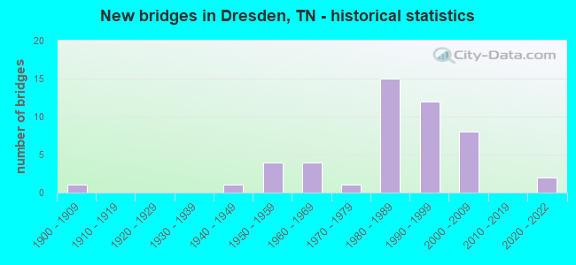
- New bridges - historical statistics
- 11900-1909
- 11940-1949
- 41950-1959
- 41960-1969
- 11970-1979
- 151980-1989
- 121990-1999
- 82000-2009
- 22020-2022


- Bridge Condition - Deck
- 6.9%Very good
- 55.2%Good
- 27.6%Satisfactory
- 10.3%Fair

- Bridge Condition - Superstructure
- 20.7%Very good
- 31.0%Good
- 34.5%Satisfactory
- 10.3%Fair
- 3.4%Poor

- Bridge Condition - Substructure
- 10.3%Very good
- 62.1%Good
- 10.3%Satisfactory
- 13.8%Fair
- 3.4%Poor

- Bridge Condition - Channel
- 27.7%Good
- 70.2%Satisfactory
- 2.1%Fair

- Bridge Condition - Culverts
- 5.6%Very good
- 16.7%Good
- 61.1%Satisfactory
- 11.1%Fair
- 5.6%Poor
Find on map >> Show street view
Structure Number: 92SR0890007, Location: 3.2 MILES NE.OF DRESDEN (Lat: 36.322639, Lng: -88.650639), Route carried "on" structure: State highway 89, Year Built: 1986, Status: Open, Structure Length: 1.40m (4.59ft), Average Daily Traffic: 1,612 (year 2020), Truck Traffic: 4%, Average Future Daily Traffic: 2,592 (year 2040), Design Load: HS 20, Features Intersected: BRANCH
Minimum Vertical Clearance: 30+ m (98+ ft), Kilometerpoint: 32.541, Lanes on structure: 2, Owner: State Highway Agency, Approaching Roadway Width: 10.1m (33.1ft), Skew: 4 degrees, Material/Design: Concrete continuous, Design/Construction: Culvert, Number Of Spans In Main Unit: 2, Length of Maximum Span: 4.6m (15.1ft)
Condition: Channel: Good, Culverts: Good, Operating Rating: 89.1 metric tons, Method Used To Determine Operating Rating: Load Factor (LF), Inventory Rating: 32.4 metric tons, Method Used To Determine Inventory Rating: Load Factor (LF), Structural Evaluation: Better than present minimum criteria, Waterway Adequacy: Equal to present desirable criteria, Approach Roadway Alignment: Equal to present desirable criteria, Designated Inspection Frequency: Every 24 months, Inspection Date: August 2020
Find on map >> Show street view
Structure Number: 92SR0890025, Location: 2.2 MI.N.OF PALMERSVILLE (Lat: 36.433222, Lng: -88.582639), Route carried "on" structure: State highway 89, Year Built: 1988, Status: Open, Structure Length: 8.78m (28.81ft), Average Daily Traffic: 709 (year 2020), Truck Traffic: 5%, Average Future Daily Traffic: 1,134 (year 2042), Design Load: HS 20, Features Intersected: OLD BED OBION RIVER
Minimum Vertical Clearance: 30+ m (98+ ft), Kilometerpoint: 46.526, Lanes on structure: 2, Owner: State Highway Agency, Approaching Roadway Width: 8.5m (27.9ft), Material/Design: Prestressed concrete, Design/Construction: Stringer/Multi-beam, Number Of Spans In Main Unit: 5, Length of Maximum Span: 18.3m (60.0ft), Curb-To-Curb Width: 10.9m (35.8ft), Out-to-Out Width: 11.1m (36.4ft)
Condition: Deck: Satisfactory, Superstructure: Good, Substructure: Good, Channel: Good, Operating Rating: 57.3 metric tons, Method Used To Determine Operating Rating: Load and Resistance Factor Rating (LRFR) rating reported by rating factor(RF) method using HL-93 loadings, Inventory Rating: 37.9 metric tons, Method Used To Determine Inventory Rating: Load and Resistance Factor Rating (LRFR) rating reported by rating factor(RF) method using HL-93 loadings, Structural Evaluation: Better than present minimum criteria, Deck Geometry: Equal to present minimum criteria, Waterway Adequacy: Equal to present desirable criteria, Approach Roadway Alignment: Equal to present desirable criteria, Designated Inspection Frequency: Every 24 months, Inspection Date: August 2020, Deck Structure Type: Concrete Precast Panels, Wearing Surface/Protective System: Wearing Surface: Monolithic Concrete
Find on map >> Show street view
Structure Number: 92SR1180001, Location: IN DRESDEN CITY LIMITS (Lat: 36.295639, Lng: -88.707639), Route carried "on" structure: State highway 118, Year Built: 1954, Status: Open, Structure Length: 4.31m (14.14ft), Average Daily Traffic: 1,652 (year 2020), Truck Traffic: 4%, Average Future Daily Traffic: 3,200 (year 2040), Design Load: H 20, Features Intersected: MUD CREEK
Minimum Vertical Clearance: 30+ m (98+ ft), Kilometerpoint: 0.418, Lanes on structure: 2, Owner: State Highway Agency, Approaching Roadway Width: 9.8m (32.2ft), Skew: 1 degrees, Material/Design: Prestressed concrete, Design/Construction: Box Beam or Girders - Single/Spread, Number Of Spans In Main Unit: 5, Length of Maximum Span: 8.9m (29.2ft), Curb-To-Curb Width: 9.1m (29.9ft), Out-to-Out Width: 9.8m (32.2ft)
Condition: Deck: Satisfactory, Superstructure: Very good, Substructure: Fair, Channel: Satisfactory, Operating Rating: 45.0 metric tons, Method Used To Determine Operating Rating: Load Factor (LF), Inventory Rating: 27.0 metric tons, Method Used To Determine Inventory Rating: Load Factor (LF), Structural Evaluation: Somewhat better than minimum adequacy, Deck Geometry: Somewhat better than minimum adequacy, Waterway Adequacy: Equal to present minimum criteria, Approach Roadway Alignment: Equal to present desirable criteria, Length Of Structure Improvement: 4.31m (14.14ft), Designated Inspection Frequency: Every 24 months, Inspection Date: August 2020, Bridge Improvement Cost: $709,000, Roadway Improvement Cost: $71,000, Total Project Cost: $1,064,000 ( Estimate for 2020), Deck Structure Type: Concrete Cast-file-Place, Wearing Surface/Protective System: Wearing Surface: Bituminous
Find on map >> Show street view
Structure Number: 92SR1180003, Location: 4.4 MI.N.OF DRESDEN (Lat: 36.359789, Lng: -88.713139), Route carried "on" structure: State highway 118, Year Built: 1954, Status: Open, Structure Length: 0.70m (2.30ft), Average Daily Traffic: 1,218 (year 2020), Truck Traffic: 5%, Average Future Daily Traffic: 1,840 (year 2040), Design Load: H 20, Features Intersected: STRAWBERRY BRANCH
Minimum Vertical Clearance: 30+ m (98+ ft), Kilometerpoint: 7.580, Lanes on structure: 2, Owner: State Highway Agency, Approaching Roadway Width: 9.1m (29.9ft), Material/Design: Concrete continuous, Design/Construction: Culvert, Number Of Spans In Main Unit: 2, Length of Maximum Span: 3.0m (9.8ft)
Condition: Channel: Satisfactory, Culverts: Poor, Operating Rating: 36.7 metric tons, Method Used To Determine Operating Rating: Load Factor (LF), Inventory Rating: 21.6 metric tons, Method Used To Determine Inventory Rating: Load Factor (LF), Structural Evaluation: Meets minimum limits, Waterway Adequacy: Equal to present minimum criteria, Approach Roadway Alignment: Equal to present desirable criteria, Length Of Structure Improvement: 0.70m (2.30ft), Designated Inspection Frequency: Every 24 months, Inspection Date: August 2020, Bridge Improvement Cost: $136,000, Roadway Improvement Cost: $14,000, Total Project Cost: $205,000 ( Estimate for 2020)
Find on map >> Show street view
Structure Number: 92008590021, Location: IN DRESDEN (Lat: 36.272278, Lng: -88.684139), Route carried "under" structure: City street 859, Year Built: 1907, Structure Length: 0. m, Average Daily Traffic: 324 (year 2020), Truck Traffic: 3%, Features Intersected: CSX RAILROAD, Facility Carried by Structure: CSX RR (ABANDONED)
Minimum Vertical Clearance: 3.23m (10.60ft), Kilometerpoint: 20.567, Lanes under structure: 1, Material/Design: Concrete, Design/Construction: Culvert, Length of Maximum Span: 4.6m (15.1ft)