Bridge Statistics for Crestview, Florida (FL)
Condition, Traffic, Stress, Structural Evaluation, Project Costs
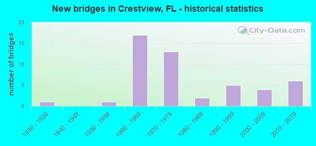
- New bridges - historical statistics
- 11930-1939
- 11950-1959
- 171960-1969
- 131970-1979
- 21980-1989
- 51990-1999
- 42000-2009
- 62010-2019

- Reconstructed bridges - Historical Statistics
- 11950-1959
- 01960-1969
- 01970-1979
- 01980-1989
- 01990-1999
- 12000-2009


- Bridge Condition - Deck
- 2.8%Very good
- 55.6%Good
- 36.1%Satisfactory
- 5.6%Fair

- Bridge Condition - Superstructure
- 83.3%Good
- 13.9%Satisfactory
- 2.8%Fair

- Bridge Condition - Substructure
- 11.1%Very good
- 58.3%Good
- 25.0%Satisfactory
- 5.6%Fair

- Bridge Condition - Channel
- 10.8%Excellent
- 18.9%Very good
- 40.5%Good
- 24.3%Satisfactory
- 5.4%Fair

- Bridge Condition - Culverts
- 28.6%Good
- 57.1%Satisfactory
- 14.3%Fair
Find on map >> Show street view
Structure Number: 570005, Location: 3.2 Miles E OF SR85 (Lat: 30.754278, Lng: -86.518258), Route carried "on" structure: US 90, Year Built: 1966, Status: Open, Structure Length: 1.01m (3.31ft), Average Daily Traffic: 11,600 (year 2020), Truck Traffic: 8%, Average Future Daily Traffic: 20,126 (year 2042), Design Load: HS 20, Features Intersected: Piney Woods Creek
Minimum Vertical Clearance: 30+ m (98+ ft), Kilometerpoint: 29.023, Lanes on structure: 6, Base Highway Network: Yes, Owner: State Highway Agency, Approaching Roadway Width: 24.4m (80.1ft), Skew: 10 degrees, Material/Design: Concrete, Design/Construction: Culvert, Number Of Spans In Main Unit: 3, Length of Maximum Span: 3.0m (9.8ft)
Condition: Channel: Satisfactory, Culverts: Good, Structural Evaluation: Better than present minimum criteria, Waterway Adequacy: Equal to present desirable criteria, Approach Roadway Alignment: Equal to present desirable criteria, Designated Inspection Frequency: Every 24 months, Inspection Date: June 2020
Find on map >> Show street view
Structure Number: 570006, Location: 3.7MI. East of SR85 (Lat: 30.753494, Lng: -86.511308), Route carried "on" structure: US 90, Year Built: 1930, Year Reconstructed: 1964, Status: Open, Structure Length: 44.81m (147.01ft), Average Daily Traffic: 7,900 (year 2020), Truck Traffic: 10%, Average Future Daily Traffic: 13,706 (year 2042), Design Load: HS 20, Features Intersected: Shoal River
Minimum Vertical Clearance: 30+ m (98+ ft), Kilometerpoint: 29.459, Lanes on structure: 2, Base Highway Network: Yes, Owner: State Highway Agency, Approaching Roadway Width: 9.8m (32.2ft), Material/Design: Steel, Design/Construction: Stringer/Multi-beam, Number Of Spans In Main Unit: 1, Number Of Approach Spans: 64, Length of Maximum Span: 37.1m (121.7ft), Curb-To-Curb Width: 8.5m (27.9ft), Out-to-Out Width: 10.4m (34.1ft)
Condition: Deck: Satisfactory, Superstructure: Fair, Substructure: Fair, Channel: Fair, Operating Rating: 50.1 metric tons, Method Used To Determine Operating Rating: Load Factor (LF), Inventory Rating: 30.0 metric tons, Method Used To Determine Inventory Rating: Load Factor (LF), Structural Evaluation: Somewhat better than minimum adequacy, Deck Geometry: Meets minimum limits, Waterway Adequacy: Equal to present minimum criteria, Approach Roadway Alignment: Equal to present minimum criteria, Designated Inspection Frequency: Every 24 months, Underwater Inspection Frequency: Every 24 months, Inspection Date: May 2021, Underwater Inspection Date: May 2021, Deck Structure Type: Concrete Cast-file-Place, Wearing Surface/Protective System: Wearing Surface: Bituminous
Find on map >> Show street view
Structure Number: 570007, Location: 0.5 Miles West of SR85 (Lat: 30.725444, Lng: -86.576694), Route carried "on" structure: Interstate 10, Year Built: 1969, Status: Open, Structure Length: 1.02m (3.35ft), Average Daily Traffic: 27,287 (year 2020), Truck Traffic: 26%, Average Future Daily Traffic: 47,343 (year 2042), Design Load: HS 20+Mod, Features Intersected: Juniper Creek
Minimum Vertical Clearance: 30+ m (98+ ft), Kilometerpoint: 21.514, Lanes on structure: 4, Base Highway Network: Yes, Owner: State Highway Agency, Approaching Roadway Width: 23.2m (76.1ft), Skew: 14 degrees, Material/Design: Concrete, Design/Construction: Culvert, Number Of Spans In Main Unit: 2, Length of Maximum Span: 5.0m (16.4ft)
Condition: Channel: Good, Culverts: Satisfactory, Inventory Rating: 84.2 metric tons, Method Used To Determine Inventory Rating: Load Factor (LF), Structural Evaluation: Equal to present minimum criteria, Waterway Adequacy: Better than present minimum criteria, Approach Roadway Alignment: Equal to present desirable criteria, Designated Inspection Frequency: Every 24 months, Underwater Inspection Frequency: Every 24 months, Inspection Date: Febuary 2021, Underwater Inspection Date: Febuary 2021
Find on map >> Show street view
Structure Number: 570008, Location: 2.0mi South of Crestview (Lat: 30.725794, Lng: -86.568606), Route carried "on" structure: Interstate 10, Year Built: 1969, Status: Open, Structure Length: 5.58m (18.31ft), Average Daily Traffic: 10,500 (year 2020), Truck Traffic: 30%, Average Future Daily Traffic: 18,218 (year 2042), Design Load: HS 20, Features Intersected: SR85
Minimum Vertical Clearance: 30+ m (98+ ft), Kilometerpoint: 22.254, Lanes on structure: 2, Lanes under structure: 5, Base Highway Network: Yes, Owner: State Highway Agency, Approaching Roadway Width: 11.6m (38.1ft), Skew: 1 degrees, Material/Design: Prestressed concrete, Design/Construction: Stringer/Multi-beam, Number Of Spans In Main Unit: 2, Length of Maximum Span: 29.6m (97.1ft), Curb-To-Curb Width: 12.2m (40.0ft), Out-to-Out Width: 13.1m (43.0ft)
Condition: Deck: Satisfactory, Superstructure: Satisfactory, Substructure: Satisfactory, Inventory Rating: 74.8 metric tons, Method Used To Determine Inventory Rating: Load Factor (LF), Structural Evaluation: Equal to present minimum criteria, Deck Geometry: Better than present minimum criteria, Underclear: Equal to present minimum criteria, Approach Roadway Alignment: Equal to present desirable criteria, Designated Inspection Frequency: Every 24 months, Inspection Date: July 2020, Deck Structure Type: Concrete Cast-file-Place
Find on map >> Show street view
Structure Number: 570009, Location: 2.5Mi. West of SR85 (Lat: 30.716206, Lng: -86.609986), Route carried "on" structure: County highway 4, Year Built: 1969, Status: Open, Structure Length: 8.69m (28.51ft), Average Daily Traffic: 9,000 (year 2020), Truck Traffic: 7%, Average Future Daily Traffic: 15,615 (year 2042), Design Load: HS 20, Features Intersected: I10 SR8
Minimum Vertical Clearance: 30+ m (98+ ft), Kilometerpoint: 0.314, Lanes on structure: 2, Lanes under structure: 4, Owner: State Highway Agency, Approaching Roadway Width: 6.7m (22.0ft), Skew: 2 degrees, Material/Design: Prestressed concrete, Design/Construction: Stringer/Multi-beam, Number Of Spans In Main Unit: 4, Length of Maximum Span: 29.7m (97.4ft), Curb-To-Curb Width: 10.1m (33.1ft), Out-to-Out Width: 10.8m (35.4ft)
Condition: Deck: Satisfactory, Superstructure: Good, Substructure: Good, Operating Rating: 59.9 metric tons, Method Used To Determine Operating Rating: Load Factor (LF), Inventory Rating: 38.1 metric tons, Method Used To Determine Inventory Rating: Load Factor (LF), Structural Evaluation: Better than present minimum criteria, Deck Geometry: Meets minimum limits, Underclear: Somewhat better than minimum adequacy, Approach Roadway Alignment: Equal to present desirable criteria, Designated Inspection Frequency: Every 24 months, Inspection Date: September 2020, Deck Structure Type: Concrete Cast-file-Place
Find on map >> Show street view
Structure Number: 570015, Location: 0.05 Mi S of Buckward Rd (Lat: 30.766361, Lng: -86.635778), Route carried "on" structure: County highway 397, Year Built: 1957, Status: Open, Structure Length: 0.96m (3.15ft), Average Daily Traffic: 1,700 (year 2020), Truck Traffic: 8%, Average Future Daily Traffic: 2,945 (year 2042), Design Load: HS 20, Features Intersected: Mill Creek, Facility Carried by Structure: Old River Road
Minimum Vertical Clearance: 30+ m (98+ ft), Kilometerpoint: 7.926, Lanes on structure: 2, Owner: County Highway Agency, Approaching Roadway Width: 6.1m (20.0ft), Material/Design: Concrete, Design/Construction: Culvert, Number Of Spans In Main Unit: 3, Length of Maximum Span: 3.3m (10.8ft)
Condition: Channel: Good, Culverts: Good, Operating Rating: 45.4 metric tons, Method Used To Determine Operating Rating: Load Factor (LF), Inventory Rating: 27.2 metric tons, Method Used To Determine Inventory Rating: Load Factor (LF), Structural Evaluation: Equal to present minimum criteria, Waterway Adequacy: Better than present minimum criteria, Approach Roadway Alignment: Equal to present desirable criteria, Designated Inspection Frequency: Every 24 months, Inspection Date: September 2021
Find on map >> Show street view
Structure Number: 570044, Location: 2.5mi. South of I10 SR8 (Lat: 30.691992, Lng: -86.572261), Route carried "on" structure: State highway 85, Year Built: 1974, Status: Open, Structure Length: 11.64m (38.19ft), Average Daily Traffic: 20,250 (year 2020), Truck Traffic: 5%, Average Future Daily Traffic: 35,134 (year 2042), Design Load: HS 20+Mod, Features Intersected: Shoal River Relief
Minimum Vertical Clearance: 30+ m (98+ ft), Kilometerpoint: 21.506, Lanes on structure: 2, Base Highway Network: Yes, Owner: State Highway Agency, Approaching Roadway Width: 8.5m (27.9ft), Material/Design: Prestressed concrete, Design/Construction: Stringer/Multi-beam, Number Of Spans In Main Unit: 6, Length of Maximum Span: 19.4m (63.6ft), Curb-To-Curb Width: 12.2m (40.0ft), Out-to-Out Width: 13.1m (43.0ft)
Condition: Deck: Good, Superstructure: Good, Substructure: Good, Channel: Good, Inventory Rating: 54.4 metric tons, Method Used To Determine Inventory Rating: Load Factor (LF), Structural Evaluation: Better than present minimum criteria, Deck Geometry: Better than present minimum criteria, Waterway Adequacy: Better than present minimum criteria, Approach Roadway Alignment: Equal to present desirable criteria, Designated Inspection Frequency: Every 24 months, Underwater Inspection Frequency: Every 24 months, Inspection Date: May 2021, Underwater Inspection Date: May 2021, Deck Structure Type: Concrete Cast-file-Place
Find on map >> Show street view
Structure Number: 570045, Location: 2.4Mi. South of I10 SR8 (Lat: 30.696164, Lng: -86.571789), Route carried "on" structure: State highway 85, Year Built: 1974, Status: Open, Structure Length: 21.35m (70.05ft), Average Daily Traffic: 20,250 (year 2020), Truck Traffic: 5%, Average Future Daily Traffic: 35,134 (year 2042), Design Load: HS 20+Mod, Features Intersected: Shoal River
Minimum Vertical Clearance: 30+ m (98+ ft), Kilometerpoint: 21.922, Lanes on structure: 2, Base Highway Network: Yes, Owner: State Highway Agency, Approaching Roadway Width: 8.5m (27.9ft), Material/Design: Prestressed concrete, Design/Construction: Stringer/Multi-beam, Number Of Spans In Main Unit: 11, Length of Maximum Span: 19.4m (63.6ft), Curb-To-Curb Width: 12.2m (40.0ft), Out-to-Out Width: 13.1m (43.0ft)
Condition: Deck: Satisfactory, Superstructure: Good, Substructure: Good, Channel: Good, Inventory Rating: 54.4 metric tons, Method Used To Determine Inventory Rating: Load Factor (LF), Structural Evaluation: Better than present minimum criteria, Deck Geometry: Better than present minimum criteria, Waterway Adequacy: Better than present minimum criteria, Approach Roadway Alignment: Equal to present desirable criteria, Designated Inspection Frequency: Every 24 months, Underwater Inspection Frequency: Every 24 months, Inspection Date: May 2021, Underwater Inspection Date: May 2021, Deck Structure Type: Concrete Cast-file-Place
Find on map >> Show street view
Structure Number: 570048, Location: 6.5MI West of SR85 (Lat: 30.715558, Lng: -86.676925), Route carried "on" structure: County highway , Year Built: 1969, Status: Open, Structure Length: 7.52m (24.67ft), Average Daily Traffic: 250 (year 2015), Truck Traffic: 1%, Average Future Daily Traffic: 441 (year 2035), Design Load: HS 20, Features Intersected: I10 SR8, Facility Carried by Structure: Wilkerson Bluff Rd
Minimum Vertical Clearance: 30+ m (98+ ft), Kilometerpoint: 8.493, Lanes on structure: 2, Lanes under structure: 4, Owner: State Highway Agency, Approaching Roadway Width: 7.3m (24.0ft), Material/Design: Prestressed concrete, Design/Construction: Stringer/Multi-beam, Number Of Spans In Main Unit: 4, Length of Maximum Span: 26.7m (87.6ft), Curb-To-Curb Width: 10.1m (33.1ft), Out-to-Out Width: 10.7m (35.1ft)
Condition: Deck: Good, Superstructure: Good, Substructure: Good, Operating Rating: 62.6 metric tons, Method Used To Determine Operating Rating: Load Factor (LF), Inventory Rating: 37.2 metric tons, Method Used To Determine Inventory Rating: Load Factor (LF), Structural Evaluation: Better than present minimum criteria, Deck Geometry: Better than present minimum criteria, Underclear: Meets minimum limits, Approach Roadway Alignment: Equal to present desirable criteria, Designated Inspection Frequency: Every 24 months, Inspection Date: January 2022, Deck Structure Type: Concrete Cast-file-Place
Find on map >> Show street view
Structure Number: 570049, Location: 5.0 Miles West of SR85 (Lat: 30.716292, Lng: -86.648775), Route carried "on" structure: Interstate 10, Year Built: 1969, Status: Open, Structure Length: 33.71m (110.60ft), Average Daily Traffic: 13,644 (year 2020), Truck Traffic: 26%, Average Future Daily Traffic: 23,671 (year 2042), Design Load: HS 20+Mod, Features Intersected: Yellow River
Minimum Vertical Clearance: 30+ m (98+ ft), Kilometerpoint: 14.157, Lanes on structure: 2, Base Highway Network: Yes, Owner: State Highway Agency, Approaching Roadway Width: 11.6m (38.1ft), Material/Design: Prestressed concrete, Design/Construction: Stringer/Multi-beam, Number Of Spans In Main Unit: 16, Length of Maximum Span: 30.5m (100.1ft), Curb-To-Curb Width: 12.2m (40.0ft), Out-to-Out Width: 13.1m (43.0ft)
Condition: Deck: Satisfactory, Superstructure: Good, Substructure: Good, Channel: Very good, Operating Rating: 67.7 metric tons, Method Used To Determine Operating Rating: Load Factor (LF), Inventory Rating: 40.6 metric tons, Method Used To Determine Inventory Rating: Load Factor (LF), Structural Evaluation: Better than present minimum criteria, Deck Geometry: Better than present minimum criteria, Waterway Adequacy: Equal to present desirable criteria, Approach Roadway Alignment: Equal to present desirable criteria, Designated Inspection Frequency: Every 24 months, Underwater Inspection Frequency: Every 24 months, Inspection Date: June 2021, Underwater Inspection Date: June 2021, Deck Structure Type: Concrete Cast-file-Place
Find on map >> Show street view
Structure Number: 57005, Location: 5.0 Miles West of SR85 (Lat: 30.716047, Lng: -86.648789), Route carried "on" structure: Interstate 10, Year Built: 1969, Status: Open, Structure Length: 33.68m (110.50ft), Average Daily Traffic: 13,644 (year 2020), Truck Traffic: 26%, Average Future Daily Traffic: 23,671 (year 2042), Design Load: HS 20+Mod, Features Intersected: Yellow River
Minimum Vertical Clearance: 30+ m (98+ ft), Kilometerpoint: 14.157, Lanes on structure: 2, Base Highway Network: Yes, Owner: State Highway Agency, Approaching Roadway Width: 11.6m (38.1ft), Material/Design: Prestressed concrete, Design/Construction: Stringer/Multi-beam, Number Of Spans In Main Unit: 16, Length of Maximum Span: 30.5m (100.1ft), Curb-To-Curb Width: 12.2m (40.0ft), Out-to-Out Width: 13.1m (43.0ft)
Condition: Deck: Satisfactory, Superstructure: Good, Substructure: Satisfactory, Channel: Very good, Operating Rating: 67.7 metric tons, Method Used To Determine Operating Rating: Load Factor (LF), Inventory Rating: 40.6 metric tons, Method Used To Determine Inventory Rating: Load Factor (LF), Structural Evaluation: Equal to present minimum criteria, Deck Geometry: Better than present minimum criteria, Waterway Adequacy: Equal to present desirable criteria, Approach Roadway Alignment: Equal to present desirable criteria, Designated Inspection Frequency: Every 24 months, Underwater Inspection Frequency: Every 24 months, Inspection Date: June 2021, Underwater Inspection Date: June 2021, Deck Structure Type: Concrete Cast-file-Place
Find on map >> Show street view
Structure Number: 570052, Location: 2.0mi South of Crestview (Lat: 30.725547, Lng: -86.568497), Route carried "on" structure: Interstate 10, Year Built: 1969, Status: Open, Structure Length: 5.58m (18.31ft), Average Daily Traffic: 10,500 (year 2020), Truck Traffic: 30%, Average Future Daily Traffic: 18,218 (year 2042), Design Load: HS 20, Features Intersected: SR85
Minimum Vertical Clearance: 30+ m (98+ ft), Kilometerpoint: 22.254, Lanes on structure: 2, Lanes under structure: 4, Base Highway Network: Yes, Owner: State Highway Agency, Approaching Roadway Width: 11.6m (38.1ft), Skew: 1 degrees, Material/Design: Prestressed concrete, Design/Construction: Stringer/Multi-beam, Number Of Spans In Main Unit: 2, Length of Maximum Span: 29.6m (97.1ft), Curb-To-Curb Width: 12.2m (40.0ft), Out-to-Out Width: 13.1m (43.0ft)
Condition: Deck: Satisfactory, Superstructure: Satisfactory, Substructure: Satisfactory, Inventory Rating: 74.7 metric tons, Method Used To Determine Inventory Rating: Load Factor (LF), Structural Evaluation: Equal to present minimum criteria, Deck Geometry: Better than present minimum criteria, Underclear: Equal to present minimum criteria, Approach Roadway Alignment: Equal to present desirable criteria, Designated Inspection Frequency: Every 24 months, Inspection Date: July 2020, Deck Structure Type: Concrete Cast-file-Place
Find on map >> Show street view
Structure Number: 570056, Location: 5.0 mi. East of SR85 (Lat: 30.722047, Lng: -86.484681), Route carried "on" structure: Interstate 10, Year Built: 1970, Status: Open, Structure Length: 0.63m (2.07ft), Average Daily Traffic: 10,500 (year 2020), Truck Traffic: 30%, Average Future Daily Traffic: 18,218 (year 2042), Design Load: HS 20+Mod, Features Intersected: Long Creek
Minimum Vertical Clearance: 30+ m (98+ ft), Kilometerpoint: 30.417, Lanes on structure: 2, Base Highway Network: Yes, Owner: State Highway Agency, Approaching Roadway Width: 11.6m (38.1ft), Material/Design: Concrete, Design/Construction: Culvert, Number Of Spans In Main Unit: 2, Length of Maximum Span: 3.0m (9.8ft)
Condition: Channel: Satisfactory, Culverts: Satisfactory, Structural Evaluation: Equal to present minimum criteria, Waterway Adequacy: Equal to present desirable criteria, Approach Roadway Alignment: Equal to present desirable criteria, Designated Inspection Frequency: Every 24 months, Inspection Date: November 2020
Find on map >> Show street view
Structure Number: 570057, Location: 5.0 miles East of SR85 (Lat: 30.724047, Lng: -86.483503), Route carried "on" structure: Interstate 10, Year Built: 1970, Status: Open, Structure Length: 0.67m (2.20ft), Average Daily Traffic: 10,500 (year 2020), Truck Traffic: 30%, Average Future Daily Traffic: 18,218 (year 2042), Design Load: HS 20+Mod, Features Intersected: Long Creek
Minimum Vertical Clearance: 30+ m (98+ ft), Kilometerpoint: 30.481, Lanes on structure: 2, Base Highway Network: Yes, Owner: State Highway Agency, Approaching Roadway Width: 11.6m (38.1ft), Skew: 2 degrees, Material/Design: Concrete, Design/Construction: Culvert, Number Of Spans In Main Unit: 2, Length of Maximum Span: 3.0m (9.8ft)
Condition: Channel: Satisfactory, Culverts: Satisfactory, Structural Evaluation: Equal to present minimum criteria, Waterway Adequacy: Equal to present desirable criteria, Approach Roadway Alignment: Equal to present desirable criteria, Designated Inspection Frequency: Every 24 months, Underwater Inspection Frequency: Every 24 months, Inspection Date: November 2020, Underwater Inspection Date: November 2020
Find on map >> Show street view
Structure Number: 570067, Location: 4.5 Miles West of SR85 (Lat: 30.715489, Lng: -86.642569), Route carried "on" structure: Interstate 10, Year Built: 1969, Status: Open, Structure Length: 12.19m (39.99ft), Average Daily Traffic: 13,644 (year 2020), Truck Traffic: 26%, Average Future Daily Traffic: 23,671 (year 2042), Design Load: HS 20+Mod, Features Intersected: Yellow River Relief
Minimum Vertical Clearance: 30+ m (98+ ft), Kilometerpoint: 14.864, Lanes on structure: 2, Base Highway Network: Yes, Owner: State Highway Agency, Approaching Roadway Width: 11.6m (38.1ft), Material/Design: Prestressed concrete, Design/Construction: Stringer/Multi-beam, Number Of Spans In Main Unit: 8, Length of Maximum Span: 15.2m (49.9ft), Curb-To-Curb Width: 12.2m (40.0ft), Out-to-Out Width: 13.1m (43.0ft)
Condition: Deck: Satisfactory, Superstructure: Good, Substructure: Good, Channel: Very good, Operating Rating: 80.7 metric tons, Method Used To Determine Operating Rating: Load Factor (LF), Inventory Rating: 48.1 metric tons, Method Used To Determine Inventory Rating: Load Factor (LF), Structural Evaluation: Better than present minimum criteria, Deck Geometry: Better than present minimum criteria, Waterway Adequacy: Equal to present desirable criteria, Approach Roadway Alignment: Equal to present desirable criteria, Designated Inspection Frequency: Every 24 months, Underwater Inspection Frequency: Every 24 months, Inspection Date: June 2021, Underwater Inspection Date: June 2021, Deck Structure Type: Concrete Cast-file-Place
Find on map >> Show street view
Structure Number: 570069, Location: 2.4 Miles East of SR85 (Lat: 30.726953, Lng: -86.522019), Route carried "on" structure: Interstate 10, Year Built: 1970, Status: Open, Structure Length: 37.06m (121.59ft), Average Daily Traffic: 10,500 (year 2020), Truck Traffic: 30%, Average Future Daily Traffic: 18,218 (year 2042), Design Load: HS 20, Features Intersected: Shoal River
Minimum Vertical Clearance: 30+ m (98+ ft), Kilometerpoint: 26.553, Lanes on structure: 2, Base Highway Network: Yes, Owner: State Highway Agency, Approaching Roadway Width: 11.6m (38.1ft), Material/Design: Prestressed concrete, Design/Construction: Stringer/Multi-beam, Number Of Spans In Main Unit: 19, Length of Maximum Span: 30.5m (100.1ft), Curb-To-Curb Width: 12.2m (40.0ft), Out-to-Out Width: 13.1m (43.0ft)
Condition: Deck: Good, Superstructure: Good, Substructure: Good, Channel: Good, Operating Rating: 75.3 metric tons, Method Used To Determine Operating Rating: Load Factor (LF), Inventory Rating: 45.4 metric tons, Method Used To Determine Inventory Rating: Load Factor (LF), Structural Evaluation: Better than present minimum criteria, Deck Geometry: Better than present minimum criteria, Waterway Adequacy: Equal to present desirable criteria, Approach Roadway Alignment: Equal to present desirable criteria, Designated Inspection Frequency: Every 24 months, Underwater Inspection Frequency: Every 24 months, Inspection Date: May 2021, Underwater Inspection Date: May 2021, Deck Structure Type: Concrete Cast-file-Place
Find on map >> Show street view
Structure Number: 570071, Location: 2.5 Mi. South of I10 SR8 (Lat: 30.691975, Lng: -86.571933), Route carried "on" structure: State highway 85, Year Built: 1974, Status: Open, Structure Length: 11.64m (38.19ft), Average Daily Traffic: 20,250 (year 2020), Truck Traffic: 5%, Average Future Daily Traffic: 35,134 (year 2042), Design Load: HS 20+Mod, Features Intersected: Shoal River Relief
Minimum Vertical Clearance: 30+ m (98+ ft), Kilometerpoint: 21.506, Lanes on structure: 2, Base Highway Network: Yes, Owner: State Highway Agency, Approaching Roadway Width: 8.5m (27.9ft), Material/Design: Prestressed concrete, Design/Construction: Stringer/Multi-beam, Number Of Spans In Main Unit: 6, Length of Maximum Span: 19.4m (63.6ft), Curb-To-Curb Width: 12.2m (40.0ft), Out-to-Out Width: 13.1m (43.0ft)
Condition: Deck: Satisfactory, Superstructure: Good, Substructure: Good, Channel: Good, Inventory Rating: 54.4 metric tons, Method Used To Determine Inventory Rating: Load Factor (LF), Structural Evaluation: Better than present minimum criteria, Deck Geometry: Better than present minimum criteria, Waterway Adequacy: Better than present minimum criteria, Approach Roadway Alignment: Equal to present desirable criteria, Designated Inspection Frequency: Every 24 months, Underwater Inspection Frequency: Every 24 months, Inspection Date: May 2021, Underwater Inspection Date: May 2021, Deck Structure Type: Concrete Cast-file-Place
Find on map >> Show street view
Structure Number: 570073, Location: 2.4 Mi. South of I10 SR8 (Lat: 30.696144, Lng: -86.571556), Route carried "on" structure: State highway 85, Year Built: 1974, Status: Open, Structure Length: 21.35m (70.05ft), Average Daily Traffic: 20,250 (year 2020), Truck Traffic: 5%, Average Future Daily Traffic: 35,134 (year 2042), Design Load: HS 20+Mod, Features Intersected: Shoal River
Minimum Vertical Clearance: 30+ m (98+ ft), Kilometerpoint: 21.922, Lanes on structure: 2, Base Highway Network: Yes, Owner: State Highway Agency, Approaching Roadway Width: 8.5m (27.9ft), Material/Design: Prestressed concrete, Design/Construction: Stringer/Multi-beam, Number Of Spans In Main Unit: 11, Length of Maximum Span: 19.4m (63.6ft), Curb-To-Curb Width: 12.2m (40.0ft), Out-to-Out Width: 13.1m (43.0ft)
Condition: Deck: Satisfactory, Superstructure: Good, Substructure: Good, Channel: Good, Inventory Rating: 54.4 metric tons, Method Used To Determine Inventory Rating: Load Factor (LF), Structural Evaluation: Better than present minimum criteria, Deck Geometry: Better than present minimum criteria, Waterway Adequacy: Better than present minimum criteria, Approach Roadway Alignment: Equal to present desirable criteria, Designated Inspection Frequency: Every 24 months, Underwater Inspection Frequency: Every 24 months, Inspection Date: May 2021, Underwater Inspection Date: May 2021, Deck Structure Type: Concrete Cast-file-Place
Find on map >> Show street view
Structure Number: 570083, Location: SR85 / CSX RR 339801J (Lat: 30.758361, Lng: -86.568219), Route carried "on" structure: State highway 85, Year Built: 1978, Status: Open, Structure Length: 7.65m (25.10ft), Average Daily Traffic: 36,500 (year 2020), Truck Traffic: 4%, Average Future Daily Traffic: 63,328 (year 2042), Design Load: HS 20, Features Intersected: FG&A RR and Bypass
Minimum Vertical Clearance: 30+ m (98+ ft), Kilometerpoint: 29.084, Lanes on structure: 4, Lanes under structure: 4, Base Highway Network: Yes, Owner: State Highway Agency, Approaching Roadway Width: 17.1m (56.1ft), Skew: 20 degrees, Material/Design: Prestressed concrete, Design/Construction: Stringer/Multi-beam, Number Of Spans In Main Unit: 3, Length of Maximum Span: 30.2m (99.1ft), Curb or Sidewalk Widths: Left: 1.5m (4.9ft), Right: 1.5m (4.9ft), Curb-To-Curb Width: 15.8m (51.8ft), Out-to-Out Width: 20.7m (67.9ft)
Condition: Deck: Fair, Superstructure: Good, Substructure: Good, Operating Rating: 81.6 metric tons, Method Used To Determine Operating Rating: Load Factor (LF), Inventory Rating: 49.0 metric tons, Method Used To Determine Inventory Rating: Load Factor (LF), Structural Evaluation: Better than present minimum criteria, Deck Geometry: Meets minimum limits, Underclear: High priority of corrective action, Approach Roadway Alignment: Equal to present desirable criteria, Designated Inspection Frequency: Every 24 months, Inspection Date: April 2021, Deck Structure Type: Concrete Cast-file-Place
Find on map >> Show street view
Structure Number: 570095, Location: 2.2 Miles W. Of SR4 (Lat: 30.727794, Lng: -86.660083), Route carried "on" structure: US 90, Year Built: 1998, Status: Open, Structure Length: 3.05m (10.01ft), Average Daily Traffic: 5,300 (year 2020), Truck Traffic: 11%, Average Future Daily Traffic: 9,196 (year 2042), Design Load: HS 20, Features Intersected: Bagget Creek
Minimum Vertical Clearance: 30+ m (98+ ft), Kilometerpoint: 13.419, Lanes on structure: 2, Base Highway Network: Yes, Owner: State Highway Agency, Approaching Roadway Width: 9.8m (32.2ft), Skew: 2 degrees, Material/Design: Prestressed concrete continuous, Design/Construction: Stringer/Multi-beam, Number Of Spans In Main Unit: 2, Length of Maximum Span: 15.2m (49.9ft), Curb-To-Curb Width: 13.4m (44.0ft), Out-to-Out Width: 14.4m (47.2ft)
Condition: Deck: Good, Superstructure: Good, Substructure: Satisfactory, Channel: Very good, Operating Rating: 68.0 metric tons, Method Used To Determine Operating Rating: Load Factor (LF), Inventory Rating: 42.6 metric tons, Method Used To Determine Inventory Rating: Load Factor (LF), Structural Evaluation: Equal to present minimum criteria, Deck Geometry: Equal to present minimum criteria, Waterway Adequacy: Superior to present desirable criteria, Approach Roadway Alignment: Equal to present desirable criteria, Designated Inspection Frequency: Every 24 months, Inspection Date: June 2020, Deck Structure Type: Concrete Cast-file-Place
Find on map >> Show street view
Structure Number: 570096, Location: 1.6 Miles West of SR4 (Lat: 30.734744, Lng: -86.653958), Route carried "on" structure: US 90, Year Built: 1998, Status: Open, Structure Length: 2.32m (7.61ft), Average Daily Traffic: 5,300 (year 2020), Truck Traffic: 11%, Average Future Daily Traffic: 9,196 (year 2042), Design Load: HS 20, Features Intersected: FG&A RR
Minimum Vertical Clearance: 30+ m (98+ ft), Kilometerpoint: 14.484, Lanes on structure: 2, Base Highway Network: Yes, Owner: State Highway Agency, Approaching Roadway Width: 10.4m (34.1ft), Skew: 3 degrees, Material/Design: Prestressed concrete, Design/Construction: Stringer/Multi-beam, Number Of Spans In Main Unit: 1, Length of Maximum Span: 23.2m (76.1ft), Curb-To-Curb Width: 13.4m (44.0ft), Out-to-Out Width: 14.4m (47.2ft)
Condition: Deck: Good, Superstructure: Good, Substructure: Good, Inventory Rating: 55.3 metric tons, Method Used To Determine Inventory Rating: Load Factor (LF), Structural Evaluation: Better than present minimum criteria, Deck Geometry: Equal to present minimum criteria, Underclear: Equal to present minimum criteria, Approach Roadway Alignment: Equal to present desirable criteria, Designated Inspection Frequency: Every 24 months, Inspection Date: July 2020, Deck Structure Type: Concrete Cast-file-Place
Find on map >> Show street view
Structure Number: 570172, Location: 3.2Mi W. of SR85 (Lat: 30.752897, Lng: -86.629125), Route carried "on" structure: US 90, Year Built: 2015, Status: Open, Structure Length: 49.29m (161.71ft), Average Daily Traffic: 16,200 (year 2020), Truck Traffic: 8%, Average Future Daily Traffic: 28,107 (year 2042), Design Load: HL 93, Features Intersected: Yellow River
Minimum Vertical Clearance: 30+ m (98+ ft), Kilometerpoint: 17.762, Lanes on structure: 2, Base Highway Network: Yes, Owner: State Highway Agency, Approaching Roadway Width: 9.8m (32.2ft), Material/Design: Prestressed concrete, Design/Construction: Stringer/Multi-beam, Number Of Spans In Main Unit: 19, Length of Maximum Span: 25.6m (84.0ft), Curb-To-Curb Width: 13.3m (43.6ft), Out-to-Out Width: 14.4m (47.2ft)
Condition: Deck: Good, Superstructure: Good, Substructure: Good, Channel: Very good, Operating Rating: 51.7 metric tons, Method Used To Determine Operating Rating: Load and Resistance Factor (LRFR), Inventory Rating: 33.9 metric tons, Method Used To Determine Inventory Rating: Load and Resistance Factor (LRFR), Structural Evaluation: Better than present minimum criteria, Deck Geometry: Somewhat better than minimum adequacy, Waterway Adequacy: Equal to present desirable criteria, Approach Roadway Alignment: Equal to present desirable criteria, Designated Inspection Frequency: Every 24 months, Underwater Inspection Frequency: Every 24 months, Inspection Date: Febuary 2022, Underwater Inspection Date: Febuary 2022, Deck Structure Type: Concrete Cast-file-Place
Find on map >> Show street view
Structure Number: 57091, Location: 2.4Mi East of SR85 (Lat: 30.727200, Lng: -86.522044), Route carried "on" structure: Interstate 10, Year Built: 1970, Status: Open, Structure Length: 37.06m (121.59ft), Average Daily Traffic: 10,500 (year 2020), Truck Traffic: 30%, Average Future Daily Traffic: 18,218 (year 2042), Design Load: HS 20+Mod, Features Intersected: Shoal River
Minimum Vertical Clearance: 30+ m (98+ ft), Kilometerpoint: 26.553, Lanes on structure: 2, Base Highway Network: Yes, Owner: State Highway Agency, Approaching Roadway Width: 11.6m (38.1ft), Material/Design: Prestressed concrete, Design/Construction: Stringer/Multi-beam, Number Of Spans In Main Unit: 19, Length of Maximum Span: 30.5m (100.1ft), Curb-To-Curb Width: 12.2m (40.0ft), Out-to-Out Width: 13.1m (43.0ft)
Condition: Deck: Good, Superstructure: Good, Substructure: Good, Channel: Very good, Operating Rating: 75.3 metric tons, Method Used To Determine Operating Rating: Load Factor (LF), Inventory Rating: 45.4 metric tons, Method Used To Determine Inventory Rating: Load Factor (LF), Structural Evaluation: Better than present minimum criteria, Deck Geometry: Better than present minimum criteria, Waterway Adequacy: Equal to present desirable criteria, Approach Roadway Alignment: Equal to present desirable criteria, Designated Inspection Frequency: Every 24 months, Underwater Inspection Frequency: Every 24 months, Inspection Date: May 2021, Underwater Inspection Date: May 2021, Deck Structure Type: Concrete Cast-file-Place
Find on map >> Show street view
Structure Number: 570951, Location: 4.5 Miles West of SR85 (Lat: 30.715739, Lng: -86.642597), Route carried "on" structure: Interstate 10, Year Built: 1969, Status: Open, Structure Length: 12.19m (39.99ft), Average Daily Traffic: 13,644 (year 2020), Truck Traffic: 26%, Average Future Daily Traffic: 23,671 (year 2042), Design Load: HS 20+Mod, Features Intersected: Yellow River Relief
Minimum Vertical Clearance: 30+ m (98+ ft), Kilometerpoint: 14.864, Lanes on structure: 2, Base Highway Network: Yes, Owner: State Highway Agency, Approaching Roadway Width: 11.9m (39.0ft), Material/Design: Prestressed concrete, Design/Construction: Stringer/Multi-beam, Number Of Spans In Main Unit: 8, Length of Maximum Span: 15.2m (49.9ft), Curb-To-Curb Width: 12.5m (41.0ft), Out-to-Out Width: 13.1m (43.0ft)
Condition: Deck: Satisfactory, Superstructure: Good, Substructure: Good, Channel: Very good, Operating Rating: 80.7 metric tons, Method Used To Determine Operating Rating: Load Factor (LF), Inventory Rating: 48.1 metric tons, Method Used To Determine Inventory Rating: Load Factor (LF), Structural Evaluation: Better than present minimum criteria, Deck Geometry: Better than present minimum criteria, Waterway Adequacy: Equal to present desirable criteria, Approach Roadway Alignment: Equal to present desirable criteria, Designated Inspection Frequency: Every 24 months, Underwater Inspection Frequency: Every 24 months, Inspection Date: June 2021, Underwater Inspection Date: June 2021, Deck Structure Type: Concrete Cast-file-Place
Find on map >> Show street view
Structure Number: 574001, Location: 1.1MI N of Hwy 10 (Lat: 30.780103, Lng: -86.600094), Route carried "on" structure: County highway , Year Built: 1976, Status: Open, Structure Length: 0.79m (2.59ft), Average Daily Traffic: 5,600 (year 2020), Truck Traffic: 5%, Average Future Daily Traffic: 9,716 (year 2042), Features Intersected: Mathison Creek, Facility Carried by Structure: Old Bethel Road
Minimum Vertical Clearance: 30+ m (98+ ft), Kilometerpoint: 1.712, Lanes on structure: 2, Owner: County Highway Agency, Approaching Roadway Width: 6.1m (20.0ft), Material/Design: Prestressed concrete, Design/Construction: Slab, Number Of Spans In Main Unit: 1, Length of Maximum Span: 7.9m (25.9ft), Curb-To-Curb Width: 6.9m (22.6ft), Out-to-Out Width: 7.3m (24.0ft)
Condition: Deck: Satisfactory, Superstructure: Satisfactory, Substructure: Fair, Channel: Satisfactory, Operating Rating: 53.5 metric tons, Method Used To Determine Operating Rating: Load Factor (LF), Inventory Rating: 31.8 metric tons, Method Used To Determine Inventory Rating: Load Factor (LF), Structural Evaluation: Somewhat better than minimum adequacy, Deck Geometry: High priority of replacement, Waterway Adequacy: Equal to present desirable criteria, Approach Roadway Alignment: Equal to present desirable criteria, Designated Inspection Frequency: Every 24 months, Other Special Inspection Frequency: Every 12 months, Inspection Date: October 2020, Other Special Inspection Date: October 2021, Deck Structure Type: Concrete Precast Panels, Wearing Surface/Protective System: Wearing Surface: Bituminous
Find on map >> Show street view
Structure Number: 574111, Location: 1.5Mi N of Galiver Cutoff (Lat: 30.749594, Lng: -86.677772), Route carried "on" structure: County highway , Year Built: 1987, Status: Posted for load-capacity, Structure Length: 0.94m (3.08ft), Average Daily Traffic: 100 (year 2021), Average Future Daily Traffic: 174 (year 2042), Design Load: HS 20, Features Intersected: Baggett Creek, Facility Carried by Structure: Keyser Mill Road
Minimum Vertical Clearance: 30+ m (98+ ft), Kilometerpoint: 2.364, Lanes on structure: 2, Owner: County Highway Agency, Approaching Roadway Width: 6.1m (20.0ft), Material/Design: Wood or Timber, Design/Construction: Stringer/Multi-beam, Number Of Spans In Main Unit: 2, Length of Maximum Span: 4.7m (15.4ft), Curb-To-Curb Width: 7.2m (23.6ft), Out-to-Out Width: 7.3m (24.0ft)
Condition: Deck: Fair, Superstructure: Good, Substructure: Satisfactory, Channel: Satisfactory, Operating Rating: 42.6 metric tons, Method Used To Determine Operating Rating: Allowable Stress (AS), Inventory Rating: 31.8 metric tons, Method Used To Determine Inventory Rating: Allowable Stress (AS), Structural Evaluation: Equal to present minimum criteria, Deck Geometry: Somewhat better than minimum adequacy, Waterway Adequacy: Better than present minimum criteria, Approach Roadway Alignment: Equal to present minimum criteria, Designated Inspection Frequency: Every 24 months, Inspection Date: October 2021, Deck Structure Type: Wood or Timber
Find on map >> Show street view
Structure Number: 574127, Location: 0.3Mi W of S Ferdon Blvd (Lat: 30.700153, Lng: -86.576133), Route carried "on" structure: County highway , Year Built: 1996, Status: Posted for load-capacity, Structure Length: 1.78m (5.84ft), Average Daily Traffic: 3,300 (year 2018), Truck Traffic: 3%, Average Future Daily Traffic: 5,726 (year 2040), Features Intersected: Juniper Creek, Facility Carried by Structure: S. Antioch Road
Minimum Vertical Clearance: 30+ m (98+ ft), Kilometerpoint: 3.701, Lanes on structure: 2, Owner: County Highway Agency, Approaching Roadway Width: 6.7m (22.0ft), Material/Design: Wood or Timber, Design/Construction: Stringer/Multi-beam, Number Of Spans In Main Unit: 4, Length of Maximum Span: 4.8m (15.7ft), Curb-To-Curb Width: 7.2m (23.6ft), Out-to-Out Width: 7.4m (24.3ft)
Condition: Deck: Good, Superstructure: Satisfactory, Substructure: Good, Channel: Excellent, Operating Rating: 36.6 metric tons, Method Used To Determine Operating Rating: Load and Resistance Factor (LRFR), Inventory Rating: 28.1 metric tons, Method Used To Determine Inventory Rating: Load and Resistance Factor (LRFR), Structural Evaluation: Equal to present minimum criteria, Deck Geometry: High priority of replacement, Waterway Adequacy: Better than present minimum criteria, Approach Roadway Alignment: Equal to present desirable criteria, Designated Inspection Frequency: Every 24 months, Underwater Inspection Frequency: Every 24 months, Inspection Date: March 2020, Underwater Inspection Date: March 2020, Deck Structure Type: Wood or Timber, Wearing Surface/Protective System: Wearing Surface: Bituminous
Find on map >> Show street view
Structure Number: 574128, Location: 0.2 Mi W of S Ferndon Blv (Lat: 30.711667, Lng: -86.574222), Route carried "on" structure: County highway , Year Built: 1987, Year Reconstructed: 2009, Status: Open, Structure Length: 1.49m (4.89ft), Average Daily Traffic: 18,400 (year 2020), Truck Traffic: 3%, Average Future Daily Traffic: 31,940 (year 2042), Design Load: HL 93, Features Intersected: Juniper Creek, Facility Carried by Structure: PJ Adams Parkway
Minimum Vertical Clearance: 30+ m (98+ ft), Kilometerpoint: 2.741, Lanes on structure: 2, Owner: County Highway Agency, Approaching Roadway Width: 7.3m (24.0ft), Skew: 4 degrees, Material/Design: Concrete, Design/Construction: Culvert, Number Of Spans In Main Unit: 3, Length of Maximum Span: 5.1m (16.7ft)
Condition: Channel: Good, Culverts: Satisfactory, Operating Rating: 47.2 metric tons, Method Used To Determine Operating Rating: Load and Resistance Factor (LRFR), Inventory Rating: 36.3 metric tons, Method Used To Determine Inventory Rating: Load and Resistance Factor (LRFR), Structural Evaluation: Equal to present minimum criteria, Waterway Adequacy: Equal to present desirable criteria, Approach Roadway Alignment: Equal to present desirable criteria, Designated Inspection Frequency: Every 24 months, Inspection Date: August 2021
Find on map >> Show street view
Structure Number: 574133, Location: 0.6 mi W of Hwy 85 (Lat: 30.726097, Lng: -86.577300), Route carried "on" structure: City street , Year Built: 1997, Status: Posted for load-capacity, Structure Length: 1.35m (4.43ft), Average Daily Traffic: 28 (year 2020), Average Future Daily Traffic: 49 (year 2042), Features Intersected: Juniper Creek, Facility Carried by Structure: Rasberry Road
Minimum Vertical Clearance: 30+ m (98+ ft), Kilometerpoint: 0.032, Lanes on structure: 2, Owner: City or Municipal Highway Agency, Approaching Roadway Width: 6.7m (22.0ft), Material/Design: Wood or Timber, Design/Construction: Stringer/Multi-beam, Number Of Spans In Main Unit: 3, Length of Maximum Span: 4.6m (15.1ft), Curb-To-Curb Width: 6.6m (21.7ft), Out-to-Out Width: 7.3m (24.0ft)
Condition: Deck: Satisfactory, Superstructure: Satisfactory, Substructure: Satisfactory, Channel: Excellent, Operating Rating: 36.6 metric tons, Method Used To Determine Operating Rating: Load and Resistance Factor (LRFR), Inventory Rating: 28.1 metric tons, Method Used To Determine Inventory Rating: Load and Resistance Factor (LRFR), Structural Evaluation: Equal to present minimum criteria, Deck Geometry: Somewhat better than minimum adequacy, Waterway Adequacy: Better than present minimum criteria, Approach Roadway Alignment: Equal to present desirable criteria, Designated Inspection Frequency: Every 24 months, Inspection Date: October 2020, Deck Structure Type: Wood or Timber, Wearing Surface/Protective System: Wearing Surface: Bituminous
Find on map >> Show street view
Structure Number: 574134, Location: 0.15 Mi N of Lake View Dr (Lat: 30.832194, Lng: -86.591861), Route carried "on" structure: County highway , Year Built: 1998, Status: Open, Structure Length: 2.07m (6.79ft), Average Daily Traffic: 75 (year 2020), Average Future Daily Traffic: 130 (year 2042), Features Intersected: Silver Creek, Facility Carried by Structure: Lake Silver Road
Minimum Vertical Clearance: 30+ m (98+ ft), Kilometerpoint: 6.238, Lanes on structure: 2, Owner: County Highway Agency, Approaching Roadway Width: 6.8m (22.3ft), Material/Design: Concrete, Design/Construction: Channel Beam, Number Of Spans In Main Unit: 2, Length of Maximum Span: 10.4m (34.1ft), Curb-To-Curb Width: 7.5m (24.6ft), Out-to-Out Width: 7.9m (25.9ft)
Condition: Deck: Good, Superstructure: Good, Substructure: Good, Channel: Fair, Operating Rating: 85.3 metric tons, Method Used To Determine Operating Rating: Load Factor (LF), Inventory Rating: 50.8 metric tons, Method Used To Determine Inventory Rating: Load Factor (LF), Structural Evaluation: Better than present minimum criteria, Deck Geometry: Equal to present minimum criteria, Waterway Adequacy: Better than present minimum criteria, Approach Roadway Alignment: Equal to present minimum criteria, Designated Inspection Frequency: Every 24 months, Inspection Date: April 2020, Deck Structure Type: Concrete Precast Panels, Wearing Surface/Protective System: Wearing Surface: Bituminous
Find on map >> Show street view
Structure Number: 574141, Location: 3.3MI N of Hwy 90 (Lat: 30.796792, Lng: -86.635292), Route carried "on" structure: Other road 397, Year Built: 2001, Status: Open, Structure Length: 1.06m (3.48ft), Average Daily Traffic: 700 (year 2020), Truck Traffic: 26%, Average Future Daily Traffic: 1,215 (year 2042), Design Load: HS 20, Features Intersected: Gum Creek
Minimum Vertical Clearance: 30+ m (98+ ft), Kilometerpoint: 3.446, Lanes on structure: 2, Owner: County Highway Agency, Approaching Roadway Width: 6.4m (21.0ft), Material/Design: Concrete, Design/Construction: Channel Beam, Number Of Spans In Main Unit: 1, Length of Maximum Span: 10.6m (34.8ft), Curb-To-Curb Width: 7.7m (25.3ft), Out-to-Out Width: 8.3m (27.2ft)
Condition: Deck: Good, Superstructure: Good, Substructure: Satisfactory, Channel: Good, Operating Rating: 84.4 metric tons, Method Used To Determine Operating Rating: Load Factor (LF), Inventory Rating: 50.8 metric tons, Method Used To Determine Inventory Rating: Load Factor (LF), Structural Evaluation: Equal to present minimum criteria, Deck Geometry: Meets minimum limits, Waterway Adequacy: Better than present minimum criteria, Approach Roadway Alignment: Equal to present minimum criteria, Designated Inspection Frequency: Every 24 months, Inspection Date: October 2020, Deck Structure Type: Concrete Precast Panels
Find on map >> Show street view
Structure Number: 574143, Location: 5.2 Mi North of US 90 (Lat: 30.822075, Lng: -86.625992), Route carried "on" structure: County highway , Year Built: 2002, Status: Open, Structure Length: 2.07m (6.79ft), Average Daily Traffic: 700 (year 2019), Truck Traffic: 26%, Average Future Daily Traffic: 1,215 (year 2041), Design Load: HS 20, Features Intersected: Cotton Creek, Facility Carried by Structure: Old River Road
Minimum Vertical Clearance: 30+ m (98+ ft), Kilometerpoint: 6.486, Lanes on structure: 2, Owner: County Highway Agency, Approaching Roadway Width: 6.4m (21.0ft), Material/Design: Concrete, Design/Construction: Channel Beam, Number Of Spans In Main Unit: 2, Length of Maximum Span: 10.4m (34.1ft), Curb-To-Curb Width: 7.6m (24.9ft), Out-to-Out Width: 8.3m (27.2ft)
Condition: Deck: Good, Superstructure: Good, Substructure: Good, Channel: Satisfactory, Inventory Rating: 68.9 metric tons, Method Used To Determine Inventory Rating: Load Factor (LF), Structural Evaluation: Better than present minimum criteria, Deck Geometry: Meets minimum limits, Waterway Adequacy: Better than present minimum criteria, Approach Roadway Alignment: Equal to present desirable criteria, Designated Inspection Frequency: Every 24 months, Inspection Date: April 2020, Deck Structure Type: Concrete Precast Panels
Find on map >> Show street view
Structure Number: 574153, Location: 0.5 Mi South of US 90 (Lat: 30.747778, Lng: -86.620833), Route carried "on" structure: County highway 4, Year Built: 1960, Status: Open, Structure Length: 0.86m (2.82ft), Average Daily Traffic: 9,000 (year 2020), Truck Traffic: 7%, Average Future Daily Traffic: 15,615 (year 2042), Features Intersected: Trammel Creek
Minimum Vertical Clearance: 30+ m (98+ ft), Kilometerpoint: 4.297, Lanes on structure: 2, Owner: County Highway Agency, Approaching Roadway Width: 7.3m (24.0ft), Material/Design: Concrete, Design/Construction: Culvert, Number Of Spans In Main Unit: 3, Length of Maximum Span: 3.0m (9.8ft)
Condition: Channel: Good, Culverts: Fair, Operating Rating: 53.5 metric tons, Method Used To Determine Operating Rating: Load Factor (LF), Inventory Rating: 34.5 metric tons, Method Used To Determine Inventory Rating: Load Factor (LF), Structural Evaluation: Somewhat better than minimum adequacy, Waterway Adequacy: Equal to present desirable criteria, Approach Roadway Alignment: Equal to present desirable criteria, Designated Inspection Frequency: Every 24 months, Inspection Date: August 2021
Find on map >> Show street view
Structure Number: 574161, Location: 0.9 Mi E of S Ferdon Blvd (Lat: 30.700214, Lng: -86.569717), Route carried "on" structure: County highway , Year Built: 2008, Status: Open, Structure Length: 0.73m (2.40ft), Average Daily Traffic: 1,000 (year 2021), Truck Traffic: 5%, Average Future Daily Traffic: 1,735 (year 2042), Design Load: HS 20, Features Intersected: Unnamed Branch, Facility Carried by Structure: Live Oak Church Rd
Minimum Vertical Clearance: 30+ m (98+ ft), Kilometerpoint: 0.146, Lanes on structure: 2, Owner: County Highway Agency, Approaching Roadway Width: 7.2m (23.6ft), Material/Design: Concrete, Design/Construction: Channel Beam, Number Of Spans In Main Unit: 1, Length of Maximum Span: 7.3m (24.0ft), Curb-To-Curb Width: 8.6m (28.2ft), Out-to-Out Width: 9.4m (30.8ft)
Condition: Deck: Good, Superstructure: Good, Substructure: Good, Channel: Good, Inventory Rating: 60.8 metric tons, Method Used To Determine Inventory Rating: Load Factor (LF), Structural Evaluation: Better than present minimum criteria, Deck Geometry: Somewhat better than minimum adequacy, Waterway Adequacy: Better than present minimum criteria, Approach Roadway Alignment: Equal to present desirable criteria, Designated Inspection Frequency: Every 24 months, Inspection Date: April 2021, Deck Structure Type: Concrete Precast Panels
Find on map >> Show street view
Structure Number: 574162, Location: 1.05 Mi E of Live Oak Ch (Lat: 30.714611, Lng: -86.542250), Route carried "on" structure: County highway , Year Built: 2008, Status: Open, Structure Length: 9.75m (31.99ft), Average Daily Traffic: 1,000 (year 2021), Average Future Daily Traffic: 1,735 (year 2042), Design Load: HS 20, Features Intersected: Unnamed Branch, Facility Carried by Structure: Airmens Mem Road
Minimum Vertical Clearance: 30+ m (98+ ft), Kilometerpoint: 1.704, Lanes on structure: 2, Owner: County Highway Agency, Approaching Roadway Width: 6.7m (22.0ft), Material/Design: Concrete, Design/Construction: Channel Beam, Number Of Spans In Main Unit: 8, Length of Maximum Span: 12.2m (40.0ft), Curb-To-Curb Width: 8.6m (28.2ft), Out-to-Out Width: 9.2m (30.2ft)
Condition: Deck: Good, Superstructure: Good, Substructure: Very good, Channel: Satisfactory, Operating Rating: 75.3 metric tons, Method Used To Determine Operating Rating: Load Factor (LF), Inventory Rating: 44.5 metric tons, Method Used To Determine Inventory Rating: Load Factor (LF), Structural Evaluation: Better than present minimum criteria, Deck Geometry: Somewhat better than minimum adequacy, Waterway Adequacy: Better than present minimum criteria, Approach Roadway Alignment: Equal to present desirable criteria, Designated Inspection Frequency: Every 24 months, Inspection Date: April 2021, Deck Structure Type: Concrete Precast Panels
Find on map >> Show street view
Structure Number: 574174, Location: 0.7 Mi N of Fairchild Rd (Lat: 30.779675, Lng: -86.516364), Route carried "on" structure: County highway , Year Built: 2010, Status: Open, Structure Length: 1.04m (3.41ft), Average Daily Traffic: 2,500 (year 2021), Truck Traffic: 4%, Average Future Daily Traffic: 4,338 (year 2042), Design Load: HL 93, Features Intersected: Mossasin Branch, Facility Carried by Structure: Fairchild Road
Minimum Vertical Clearance: 30+ m (98+ ft), Kilometerpoint: 1.114, Lanes on structure: 2, Owner: County Highway Agency, Approaching Roadway Width: 7.3m (24.0ft), Material/Design: Concrete, Design/Construction: Channel Beam, Number Of Spans In Main Unit: 1, Length of Maximum Span: 10.4m (34.1ft), Curb-To-Curb Width: 8.5m (27.9ft), Out-to-Out Width: 9.5m (31.2ft)
Condition: Deck: Good, Superstructure: Good, Substructure: Very good, Channel: Excellent, Operating Rating: 65.3 metric tons, Method Used To Determine Operating Rating: Load and Resistance Factor (LRFR), Inventory Rating: 50.8 metric tons, Method Used To Determine Inventory Rating: Load and Resistance Factor (LRFR), Structural Evaluation: Better than present minimum criteria, Deck Geometry: Meets minimum limits, Waterway Adequacy: Meets minimum limits, Approach Roadway Alignment: Equal to present desirable criteria, Designated Inspection Frequency: Every 24 months, Inspection Date: March 2021, Deck Structure Type: Concrete Precast Panels
Find on map >> Show street view
Structure Number: 574192, Location: 1.2 Mi South of US 90 (Lat: 30.739556, Lng: -86.535139), Route carried "on" structure: County highway , Year Built: 2017, Status: Open, Structure Length: 1.04m (3.41ft), Average Daily Traffic: 200 (year 2020), Average Future Daily Traffic: 347 (year 2042), Design Load: HL 93, Features Intersected: No Name Stream, Facility Carried by Structure: Okaloosa Lane
Minimum Vertical Clearance: 30+ m (98+ ft), Kilometerpoint: 1.545, Lanes on structure: 2, Owner: County Highway Agency, Approaching Roadway Width: 7.5m (24.6ft), Material/Design: Concrete, Design/Construction: Channel Beam, Number Of Spans In Main Unit: 1, Length of Maximum Span: 10.4m (34.1ft), Curb or Sidewalk Widths: Left: 1.2m (3.9ft), Right: 0.0m, Curb-To-Curb Width: 7.5m (24.6ft), Out-to-Out Width: 8.9m (29.2ft)
Condition: Deck: Good, Superstructure: Good, Substructure: Very good, Channel: Good, Operating Rating: 43.4 metric tons, Method Used To Determine Operating Rating: Load and Resistance Factor (LRFR), Inventory Rating: 33.5 metric tons, Method Used To Determine Inventory Rating: Load and Resistance Factor (LRFR), Structural Evaluation: Better than present minimum criteria, Deck Geometry: Somewhat better than minimum adequacy, Waterway Adequacy: Equal to present desirable criteria, Approach Roadway Alignment: Equal to present desirable criteria, Designated Inspection Frequency: Every 24 months, Inspection Date: January 2022, Deck Structure Type: Concrete Precast Panels
Find on map >> Show street view
Structure Number: 574193, Location: 1.8 Mi South of I 10 (Lat: 30.690167, Lng: -86.679167), Route carried "on" structure: County highway , Year Built: 2018, Status: Open, Structure Length: 1.04m (3.41ft), Average Daily Traffic: 250 (year 2020), Truck Traffic: 1%, Average Future Daily Traffic: 434 (year 2042), Design Load: HL 93, Features Intersected: Wilkinson Creek, Facility Carried by Structure: Wilkerson Bluff Rd
Minimum Vertical Clearance: 30+ m (98+ ft), Kilometerpoint: 5.589, Lanes on structure: 2, Owner: County Highway Agency, Approaching Roadway Width: 6.3m (20.7ft), Material/Design: Concrete, Design/Construction: Channel Beam, Number Of Spans In Main Unit: 1, Length of Maximum Span: 10.4m (34.1ft), Curb-To-Curb Width: 7.5m (24.6ft), Out-to-Out Width: 8.2m (26.9ft)
Condition: Deck: Very good, Superstructure: Good, Substructure: Very good, Channel: Good, Operating Rating: 43.7 metric tons, Method Used To Determine Operating Rating: Load and Resistance Factor (LRFR), Inventory Rating: 33.7 metric tons, Method Used To Determine Inventory Rating: Load and Resistance Factor (LRFR), Structural Evaluation: Better than present minimum criteria, Deck Geometry: Somewhat better than minimum adequacy, Waterway Adequacy: Better than present minimum criteria, Approach Roadway Alignment: Equal to present minimum criteria, Designated Inspection Frequency: Every 24 months, Inspection Date: May 2020, Deck Structure Type: Concrete Cast-file-Place
Find on map >> Show street view
Structure Number: 575173, Location: 0.4Mi NW of CR 188 (Lat: 30.780444, Lng: -86.603333), Route carried "on" structure: City street , Year Built: 1975, Status: Open, Structure Length: 0.85m (2.79ft), Average Daily Traffic: 250 (year 2021), Truck Traffic: 1%, Average Future Daily Traffic: 434 (year 2042), Features Intersected: Mathison Creek, Facility Carried by Structure: Sioux Circle
Minimum Vertical Clearance: 30+ m (98+ ft), Kilometerpoint: 0.600, Lanes on structure: 2, Owner: City or Municipal Highway Agency, Approaching Roadway Width: 6.4m (21.0ft), Material/Design: Steel, Design/Construction: Stringer/Multi-beam, Number Of Spans In Main Unit: 1, Length of Maximum Span: 8.5m (27.9ft), Curb-To-Curb Width: 7.0m (23.0ft), Out-to-Out Width: 7.6m (24.9ft)
Condition: Deck: Good, Superstructure: Good, Substructure: Good, Channel: Excellent, Operating Rating: 34.5 metric tons, Method Used To Determine Operating Rating: Load and Resistance Factor (LRFR), Inventory Rating: 26.3 metric tons, Method Used To Determine Inventory Rating: Load and Resistance Factor (LRFR), Structural Evaluation: Equal to present minimum criteria, Deck Geometry: Meets minimum limits, Waterway Adequacy: Equal to present minimum criteria, Approach Roadway Alignment: Equal to present desirable criteria, Designated Inspection Frequency: Every 24 months, Inspection Date: Febuary 2021, Deck Structure Type: Concrete Cast-file-Place
Find on map >> Show street view
Structure Number: AFFLFTFA12206, Location: 3 MILES WEST OF U.S. 85 (Lat: 30.671269, Lng: -86.661992), Route carried "on" structure: Federal lands road 211, Year Built: 2016, Status: Posted for load, Structure Length: 2.07m (6.79ft), Average Daily Traffic: 50 (year 2021), Average Future Daily Traffic: 55 (year 2041), Design Load: HS 20, Features Intersected: TURKEY GOBBLER CREEK
Minimum Vertical Clearance: 30+ m (98+ ft), Kilometerpoint: 0.000, Lanes on structure: 2, Owner: Air Force, Approaching Roadway Width: 6.1m (20.0ft), Material/Design: Concrete, Design/Construction: Channel Beam, Number Of Spans In Main Unit: 2, Length of Maximum Span: 10.4m (34.1ft), Curb-To-Curb Width: 8.6m (28.2ft), Out-to-Out Width: 9.4m (30.8ft)
Condition: Deck: Good, Superstructure: Good, Substructure: Good, Channel: Good, Operating Rating: 68.2 metric tons, Method Used To Determine Operating Rating: Load Factor (LF), Inventory Rating: 40.8 metric tons, Method Used To Determine Inventory Rating: Load Factor (LF), Structural Evaluation: Better than present minimum criteria, Waterway Adequacy: Equal to present minimum criteria, Approach Roadway Alignment: Equal to present desirable criteria, Designated Inspection Frequency: Every 24 months, Inspection Date: October 2021
Find on map >> Show street view
Structure Number: AFFLFTFA12213, Location: 5.2 MILES EAST OF S.R. 85 (Lat: 30.693889, Lng: -86.496142), Route carried "on" structure: Federal lands road 211, Year Built: 1965, Status: Open, Structure Length: 0.92m (3.02ft), Average Daily Traffic: 50 (year 2021), Average Future Daily Traffic: 55 (year 2041), Features Intersected: HONEY CREEK
Minimum Vertical Clearance: 30+ m (98+ ft), Kilometerpoint: 0.000, Lanes on structure: 1, Owner: Air Force, Approaching Roadway Width: 4.9m (16.1ft), Material/Design: Concrete, Design/Construction: Slab, Number Of Spans In Main Unit: 1, Length of Maximum Span: 8.6m (28.2ft), Curb-To-Curb Width: 4.6m (15.1ft), Out-to-Out Width: 4.9m (16.1ft)
Condition: Deck: Good, Superstructure: Good, Substructure: Satisfactory, Channel: Good, Operating Rating: 50.8 metric tons, Method Used To Determine Operating Rating: Load Factor (LF), Inventory Rating: 29.9 metric tons, Method Used To Determine Inventory Rating: Load Factor (LF), Structural Evaluation: Equal to present minimum criteria, Deck Geometry: Better than present minimum criteria, Waterway Adequacy: Equal to present minimum criteria, Approach Roadway Alignment: Equal to present desirable criteria, Designated Inspection Frequency: Every 24 months, Inspection Date: October 2021, Deck Structure Type: Concrete Precast Panels, Wearing Surface/Protective System: Wearing Surface: Bituminous
Find on map >> Show street view
Structure Number: AFFLFTFA12219, Location: 1 MILES NORTH OF RANGE RO (Lat: 30.701611, Lng: -86.492194), Route carried "on" structure: Federal lands road 207, Year Built: 1965, Status: Open, Structure Length: 1.61m (5.28ft), Average Daily Traffic: 5 (year 2021), Average Future Daily Traffic: 6 (year 2041), Features Intersected: TITI CREEK
Minimum Vertical Clearance: 30+ m (98+ ft), Kilometerpoint: 0.000, Lanes on structure: 1, Owner: Air Force, Approaching Roadway Width: 3.7m (12.1ft), Material/Design: Prestressed concrete, Design/Construction: Slab, Number Of Spans In Main Unit: 2, Length of Maximum Span: 8.0m (26.2ft), Curb-To-Curb Width: 3.4m (11.2ft), Out-to-Out Width: 3.7m (12.1ft)
Condition: Deck: Good, Superstructure: Good, Substructure: Satisfactory, Channel: Satisfactory, Operating Rating: 75.3 metric tons, Method Used To Determine Operating Rating: Load Factor (LF), Inventory Rating: 45.4 metric tons, Method Used To Determine Inventory Rating: Load Factor (LF), Structural Evaluation: Equal to present minimum criteria, Deck Geometry: High priority of corrective action, Waterway Adequacy: Equal to present minimum criteria, Approach Roadway Alignment: Equal to present desirable criteria, Designated Inspection Frequency: Every 24 months, Inspection Date: October 2021, Deck Structure Type: Concrete Precast Panels
Find on map >> Show street view
Structure Number: AFFLFTFA12255, Location: 4.9 MILES WEST OF SR 85 (Lat: 30.674694, Lng: -86.650778), Route carried "on" structure: Federal lands road 211, Year Built: 2015, Status: Posted for load, Structure Length: 1.04m (3.41ft), Average Daily Traffic: 50 (year 2021), Average Future Daily Traffic: 60 (year 2041), Features Intersected: CARR SPRING BRANCH
Minimum Vertical Clearance: 30+ m (98+ ft), Kilometerpoint: 0.000, Lanes on structure: 2, Owner: Air Force, Approaching Roadway Width: 6.6m (21.7ft), Material/Design: Concrete, Design/Construction: Channel Beam, Number Of Spans In Main Unit: 1, Length of Maximum Span: 9.7m (31.8ft), Curb-To-Curb Width: 8.6m (28.2ft), Out-to-Out Width: 9.4m (30.8ft)
Condition: Deck: Good, Superstructure: Good, Substructure: Good, Channel: Satisfactory, Operating Rating: 68.2 metric tons, Method Used To Determine Operating Rating: Field evaluation and documented engineering judgment, Inventory Rating: 40.8 metric tons, Method Used To Determine Inventory Rating: Field evaluation and documented engineering judgment, Structural Evaluation: Better than present minimum criteria, Deck Geometry: Better than present minimum criteria, Waterway Adequacy: Equal to present desirable criteria, Approach Roadway Alignment: Equal to present desirable criteria, Designated Inspection Frequency: Every 24 months, Inspection Date: October 2021, Bridge Improvement Cost: $25,000, Roadway Improvement Cost: $3,000, Total Project Cost: $38,000 ( Estimate for 2017)
Find on map >> Show street view
Structure Number: 570008, Location: 2.0mi South of Crestview (Lat: 30.725794, Lng: -86.568606), Route carried "under" structure: State highway 85, Year Built: 1969, Structure Length: 0. m, Average Daily Traffic: 46,500 (year 2020), Truck Traffic: 5%, Features Intersected: SR85, Facility Carried by Structure: I10 SR8
Minimum Vertical Clearance: 5.18m (16.99ft), Kilometerpoint: 25.320, Lanes on structure: 2, Lanes under structure: 5, Material/Design: Prestressed concrete, Design/Construction: Stringer/Multi-beam, Length of Maximum Span: 29.6m (97.1ft)
Find on map >> Show street view
Structure Number: 570009, Location: 2.5Mi. West of SR85 (Lat: 30.716206, Lng: -86.609986), Route carried "under" structure: Interstate 10, Year Built: 1969, Structure Length: 0. m, Average Daily Traffic: 27,287 (year 2020), Truck Traffic: 26%, Features Intersected: I10 SR8, Facility Carried by Structure: CR4; Antioch Road
Minimum Vertical Clearance: 4.91m (16.11ft), Kilometerpoint: 18.094, Lanes on structure: 2, Lanes under structure: 4, Material/Design: Prestressed concrete, Design/Construction: Stringer/Multi-beam, Length of Maximum Span: 29.7m (97.4ft)
Find on map >> Show street view
Structure Number: 570048, Location: 6.5MI West of SR85 (Lat: 30.715558, Lng: -86.676925), Route carried "under" structure: Interstate 10, Year Built: 1969, Structure Length: 0. m, Average Daily Traffic: 27,287 (year 2020), Truck Traffic: 26%, Features Intersected: I10 SR8, Facility Carried by Structure: Wilkerson Bluff Rd
Minimum Vertical Clearance: 5.00m (16.40ft), Kilometerpoint: 11.629, Lanes on structure: 2, Lanes under structure: 4, Material/Design: Prestressed concrete, Design/Construction: Stringer/Multi-beam, Length of Maximum Span: 26.7m (87.6ft)