Bridge Statistics for Cranston, Rhode Island (RI)
Condition, Traffic, Stress, Structural Evaluation, Project Costs
- National Bridge Inventory (NBI) Statistics
- 92Number of bridges
- 797ft / 243mTotal length
- $195,936,000Total costs
- 2,644,609Total average daily traffic
- 226,626Total average daily truck traffic
- National Bridge Inventory (NBI) Registered Bridges for Cranston
- No street view available for this location
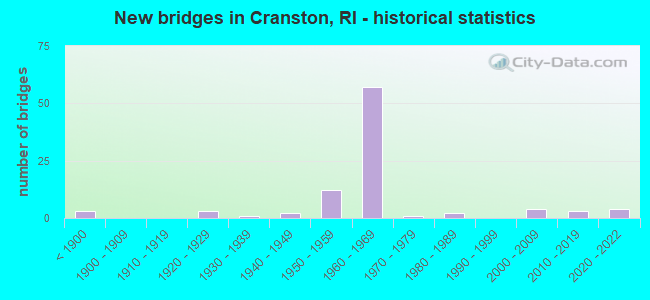
- New bridges - historical statistics
- 3Before 1900
- 31920-1929
- 11930-1939
- 21940-1949
- 121950-1959
- 571960-1969
- 11970-1979
- 21980-1989
- 42000-2009
- 32010-2019
- 42020-2022

- Reconstructed bridges - Historical Statistics
- 11920-1929
- 01930-1939
- 01940-1949
- 01950-1959
- 01960-1969
- 11970-1979
- 141980-1989
- 71990-1999
- 22000-2009


- Bridge Condition - Deck
- 5.9%Very good
- 23.5%Good
- 37.3%Satisfactory
- 21.6%Fair
- 7.8%Poor
- 2.0%Serious
- 2.0%Critical

- Bridge Condition - Superstructure
- 6.9%Very good
- 5.2%Good
- 31.0%Satisfactory
- 34.5%Fair
- 19.0%Poor
- 3.4%Serious

- Bridge Condition - Substructure
- 13.8%Good
- 44.8%Satisfactory
- 25.9%Fair
- 15.5%Poor

- Bridge Condition - Channel
- 26.1%Good
- 30.4%Satisfactory
- 39.1%Fair
- 4.3%Poor

- Bridge Condition - Culverts
- 12.5%Very good
- 37.5%Good
- 37.5%Satisfactory
- 12.5%Poor
Find on map >> Show street view
Structure Number: 15, Location: 0.1 Mi N of JCT RI 402 (Lat: 41.634178, Lng: -71.467825), Route carried "on" structure: US 1, Year Built: 1930, Status: Posted for load, Structure Length: 1.01m (3.31ft), Average Daily Traffic: 25,883 (year 2015), Truck Traffic: 1%, Average Future Daily Traffic: 31,060 (year 2036), Design Load: H 20, Features Intersected: HUNT RIVER
Minimum Vertical Clearance: 30+ m (98+ ft), Kilometerpoint: 58.653, Lanes on structure: 3, Base Highway Network: Yes, Owner: State Highway Agency, Approaching Roadway Width: 12.2m (40.0ft), Material/Design: Concrete, Design/Construction: Tee Beam, Number Of Spans In Main Unit: 1, Length of Maximum Span: 8.5m (27.9ft), Curb or Sidewalk Widths: Left: 2.5m (8.2ft), Right: 2.5m (8.2ft), Curb-To-Curb Width: 12.2m (40.0ft), Out-to-Out Width: 18.3m (60.0ft)
Condition: Deck: Satisfactory, Superstructure: Satisfactory, Substructure: Satisfactory, Channel: Good, Operating Rating: 26.9 metric tons, Method Used To Determine Operating Rating: Load and Resistance Factor Rating (LRFR) rating reported by rating factor(RF) method using HL-93 loadings, Inventory Rating: 20.7 metric tons, Method Used To Determine Inventory Rating: Load and Resistance Factor Rating (LRFR) rating reported by rating factor(RF) method using HL-93 loadings, Structural Evaluation: Somewhat better than minimum adequacy, Deck Geometry: Meets minimum limits, Waterway Adequacy: Equal to present desirable criteria, Approach Roadway Alignment: Equal to present minimum criteria, Bridge Posting: Required (Relationship of Operating Rating to Maximum Legal Load: 20.0 - 29.9% below), Length Of Structure Improvement: 1.01m (3.31ft), Designated Inspection Frequency: Every 24 months, Other Special Inspection Frequency: Every 12 months, Inspection Date: November 2021, Other Special Inspection Date: November 2021, Bridge Improvement Cost: $385,000, Roadway Improvement Cost: $38,000, Total Project Cost: $577,000, Deck Structure Type: Concrete Cast-file-Place, Wearing Surface/Protective System: Wearing Surface: Bituminous
Find on map >> Show street view
Structure Number: 23, Location: 1.0 Mi S of JCT RI 12 (Lat: 41.770731, Lng: -71.453772), Route carried "on" structure: State highway 2, Year Built: 1926, Year Reconstructed: 2014, Status: Open, Structure Length: 1.19m (3.90ft), Average Daily Traffic: 26,364 (year 2021), Truck Traffic: 13%, Average Future Daily Traffic: 29,000 (year 2041), Design Load: HS 25 or greater, Features Intersected: POCASSET RIVER
Minimum Vertical Clearance: 30+ m (98+ ft), Kilometerpoint: 50.241, Lanes on structure: 4, Base Highway Network: Yes, Owner: State Highway Agency, Approaching Roadway Width: 19.5m (64.0ft), Skew: 20 degrees, Material/Design: Steel, Design/Construction: Stringer/Multi-beam, Number Of Spans In Main Unit: 1, Length of Maximum Span: 10.5m (34.4ft), Curb or Sidewalk Widths: Left: 2.0m (6.6ft), Right: 2.0m (6.6ft), Curb-To-Curb Width: 19.5m (64.0ft), Out-to-Out Width: 24.4m (80.1ft)
Condition: Deck: Good, Superstructure: Good, Substructure: Good, Channel: Satisfactory, Operating Rating: 86.5 metric tons, Method Used To Determine Operating Rating: Load and Resistance Factor Rating (LRFR) rating reported by rating factor(RF) method using HL-93 loadings, Inventory Rating: 66.7 metric tons, Method Used To Determine Inventory Rating: Load and Resistance Factor Rating (LRFR) rating reported by rating factor(RF) method using HL-93 loadings, Structural Evaluation: Better than present minimum criteria, Deck Geometry: Better than present minimum criteria, Waterway Adequacy: Equal to present desirable criteria, Approach Roadway Alignment: Equal to present desirable criteria, Length Of Structure Improvement: 1.13m (3.71ft), Designated Inspection Frequency: Every 24 months, Inspection Date: April 2020, Bridge Improvement Cost: $1,221,000, Roadway Improvement Cost: $122,000, Total Project Cost: $1,832,000, Deck Structure Type: Concrete Cast-file-Place, Wearing Surface/Protective System: Wearing Surface: Monolithic Concrete, Membrane: Other
Find on map >> Show street view
Structure Number: 24, Location: 0.1 Mi S of JCT RI 2 (Lat: 41.735406, Lng: -71.481647), Route carried "on" structure: Ramp State highway 33, Year Built: 1953, Status: Open, Structure Length: 0.88m (2.89ft), Average Daily Traffic: 15,040 (year 2016), Truck Traffic: 10%, Average Future Daily Traffic: 16,080 (year 2036), Features Intersected: MESHANTICUT BROOK
Minimum Vertical Clearance: 30+ m (98+ ft), Kilometerpoint: 0.267, Lanes on structure: 3, Owner: State Highway Agency, Approaching Roadway Width: 16.2m (53.1ft), Skew: 20 degrees, Material/Design: Concrete, Design/Construction: Culvert, Number Of Spans In Main Unit: 2, Length of Maximum Span: 4.3m (14.1ft), Curb or Sidewalk Widths: Left: 1.1m (3.6ft), Right: 0.0m, Out-to-Out Width: 16.2m (53.1ft)
Condition: Channel: Satisfactory, Culverts: Satisfactory, Inventory Rating: 88.2 metric tons, Method Used To Determine Inventory Rating: Load and Resistance Factor (LRFR), Structural Evaluation: Equal to present minimum criteria, Waterway Adequacy: Equal to present desirable criteria, Approach Roadway Alignment: Better than present minimum criteria, Length Of Structure Improvement: 0.98m (3.22ft), Designated Inspection Frequency: Every 24 months, Inspection Date: May 2020, Bridge Improvement Cost: $1,763,000, Roadway Improvement Cost: $176,000, Total Project Cost: $2,645,000
Find on map >> Show street view
Structure Number: 25, Location: 0.3 Mi W of JCT RI 2 (Lat: 41.734600, Lng: -71.483053), Route carried "on" structure: Alternate State highway 33, Year Built: 2000, Status: Open, Structure Length: 1.01m (3.31ft), Average Daily Traffic: 11,615 (year 2014), Truck Traffic: 1%, Average Future Daily Traffic: 13,938 (year 2036), Design Load: HS 25 or greater, Features Intersected: WASH SEC BIKE PATH
Minimum Vertical Clearance: 30+ m (98+ ft), Kilometerpoint: 10.610, Lanes on structure: 2, Owner: State Highway Agency, Approaching Roadway Width: 12.2m (40.0ft), Skew: 5 degrees, Material/Design: Concrete, Design/Construction: Arch - Deck, Number Of Spans In Main Unit: 1, Length of Maximum Span: 7.6m (24.9ft), Curb or Sidewalk Widths: Left: 1.7m (5.6ft), Right: 1.7m (5.6ft), Curb-To-Curb Width: 12.2m (40.0ft), Out-to-Out Width: 43.3m (142.1ft)
Condition: Superstructure: Good, Substructure: Good, Inventory Rating: 97.2 metric tons, Method Used To Determine Inventory Rating: Load and Resistance Factor Rating (LRFR) rating reported by rating factor(RF) method using HL-93 loadings, Structural Evaluation: Better than present minimum criteria, Deck Geometry: Somewhat better than minimum adequacy, Approach Roadway Alignment: Equal to present desirable criteria, Length Of Structure Improvement: 1.83m (6.00ft), Designated Inspection Frequency: Every 24 months, Inspection Date: August 2021, Bridge Improvement Cost: $421,000, Roadway Improvement Cost: $42,000, Total Project Cost: $632,000, Wearing Surface/Protective System: Wearing Surface: Bituminous
Find on map >> Show street view
Structure Number: 81, Location: 0.2 Mi E of JCT RI 5 (Lat: 41.796953, Lng: -71.479547), Route carried "on" structure: State highway 14, Year Built: 1897, Status: Posted for load, Structure Length: 0.98m (3.22ft), Average Daily Traffic: 11 (year 2021), Truck Traffic: 3%, Average Future Daily Traffic: 12 (year 2041), Design Load: HS 20, Features Intersected: POCASSET RIVER
Minimum Vertical Clearance: 30+ m (98+ ft), Kilometerpoint: 33.075, Lanes on structure: 2, Owner: State Highway Agency, Approaching Roadway Width: 10.7m (35.1ft), Material/Design: Masonry, Design/Construction: Arch - Deck, Number Of Spans In Main Unit: 1, Length of Maximum Span: 9.8m (32.2ft), Curb or Sidewalk Widths: Left: 1.8m (5.9ft), Right: 2.1m (6.9ft), Curb-To-Curb Width: 11.6m (38.1ft), Out-to-Out Width: 15.5m (50.9ft)
Condition: Superstructure: Serious, Substructure: Satisfactory, Channel: Fair, Operating Rating: 43.0 metric tons, Method Used To Determine Operating Rating: Allowable Stress (AS), Inventory Rating: 25.8 metric tons, Method Used To Determine Inventory Rating: Allowable Stress (AS), Structural Evaluation: High priority of corrective action, Deck Geometry: Superior to present desirable criteria, Waterway Adequacy: Equal to present desirable criteria, Approach Roadway Alignment: Somewhat better than minimum adequacy, Bridge Posting: Required (Relationship of Operating Rating to Maximum Legal Load: 0.1 - 9.9% below), Length Of Structure Improvement: 0.98m (3.22ft), Designated Inspection Frequency: Every 24 months, Other Special Inspection Frequency: Every 12 months, Inspection Date: July 2020, Other Special Inspection Date: July 2021, Bridge Improvement Cost: $316,000, Roadway Improvement Cost: $32,000, Total Project Cost: $474,000
Find on map >> Show street view
Structure Number: 15, Location: 0.5 Mi S of JCT RI 12 (Lat: 41.767656, Lng: -71.405214), Route carried "on" structure: State highway 117, Year Built: 1921, Year Reconstructed: 1986, Status: Open, Structure Length: 4.66m (15.29ft), Average Daily Traffic: 18,888 (year 2014), Truck Traffic: 1%, Average Future Daily Traffic: 22,666 (year 2036), Design Load: HS 20, Features Intersected: PAWTUXET RIVER
Minimum Vertical Clearance: 30+ m (98+ ft), Kilometerpoint: 2.791, Lanes on structure: 4, Base Highway Network: Yes, Owner: State Highway Agency, Approaching Roadway Width: 15.8m (51.8ft), Material/Design: Concrete, Design/Construction: Arch - Deck, Number Of Spans In Main Unit: 3, Length of Maximum Span: 16.2m (53.1ft), Curb or Sidewalk Widths: Left: 1.8m (5.9ft), Right: 1.8m (5.9ft), Curb-To-Curb Width: 15.8m (51.8ft), Out-to-Out Width: 20.1m (65.9ft)
Condition: Superstructure: Satisfactory, Substructure: Satisfactory, Channel: Fair, Operating Rating: 42.1 metric tons, Method Used To Determine Operating Rating: Load and Resistance Factor Rating (LRFR) rating reported by rating factor(RF) method using HL-93 loadings, Inventory Rating: 32.7 metric tons, Method Used To Determine Inventory Rating: Load and Resistance Factor Rating (LRFR) rating reported by rating factor(RF) method using HL-93 loadings, Structural Evaluation: Equal to present minimum criteria, Deck Geometry: Meets minimum limits, Waterway Adequacy: Equal to present desirable criteria, Approach Roadway Alignment: Equal to present desirable criteria, Length Of Structure Improvement: 4.66m (15.29ft), Designated Inspection Frequency: Every 24 months, Underwater Inspection Frequency: Every 48 months, Inspection Date: September 2020, Underwater Inspection Date: September 2020, Bridge Improvement Cost: $1,128,000, Roadway Improvement Cost: $113,000, Total Project Cost: $1,692,000
Find on map >> Show street view
Structure Number: 19, Location: 1.0 Mi E of JCT RI 117 (Lat: 41.764447, Lng: -71.390536), Route carried "on" structure: Alternate US 1, Year Built: 1884, Year Reconstructed: 1932, Status: Open, Structure Length: 3.38m (11.09ft), Average Daily Traffic: 2,425 (year 2021), Truck Traffic: 4%, Average Future Daily Traffic: 2,668 (year 2041), Design Load: HS 20, Features Intersected: PAWTUXET RIVER
Minimum Vertical Clearance: 30+ m (98+ ft), Kilometerpoint: 0.018, Lanes on structure: 2, Owner: State Highway Agency, Approaching Roadway Width: 12.2m (40.0ft), Material/Design: Concrete, Design/Construction: Arch - Deck, Number Of Spans In Main Unit: 3, Length of Maximum Span: 14.0m (45.9ft), Curb or Sidewalk Widths: Left: 2.7m (8.9ft), Right: 2.7m (8.9ft), Curb-To-Curb Width: 12.2m (40.0ft), Out-to-Out Width: 18.4m (60.4ft)
Condition: Superstructure: Fair, Substructure: Fair, Channel: Fair, Operating Rating: 47.6 metric tons, Method Used To Determine Operating Rating: Load and Resistance Factor Rating (LRFR) rating reported by rating factor(RF) method using HL-93 loadings, Inventory Rating: 36.6 metric tons, Method Used To Determine Inventory Rating: Load and Resistance Factor Rating (LRFR) rating reported by rating factor(RF) method using HL-93 loadings, Structural Evaluation: Somewhat better than minimum adequacy, Deck Geometry: Equal to present minimum criteria, Waterway Adequacy: Equal to present desirable criteria, Approach Roadway Alignment: Equal to present desirable criteria, Length Of Structure Improvement: 2.99m (9.81ft), Designated Inspection Frequency: Every 24 months, Underwater Inspection Frequency: Every 48 months, Inspection Date: September 2020, Underwater Inspection Date: September 2020, Bridge Improvement Cost: $1,145,000, Roadway Improvement Cost: $114,000, Total Project Cost: $1,717,000
Find on map >> Show street view
Structure Number: 201, Location: 0.8 Mi N of JCT RI 37 (Lat: 41.759831, Lng: -71.443311), Route carried "on" structure: City street , Year Built: 1925, Status: Posted for load-capacity, Structure Length: 1.16m (3.81ft), Average Daily Traffic: 12,700 (year 2021), Truck Traffic: 3%, Average Future Daily Traffic: 13,970 (year 2041), Design Load: HS 20, Features Intersected: POCASSET RIVER, Facility Carried by Structure: PONTIAC AV
Minimum Vertical Clearance: 30+ m (98+ ft), Kilometerpoint: 4.310, Lanes on structure: 2, Owner: State Highway Agency, Approaching Roadway Width: 12.2m (40.0ft), Skew: 3 degrees, Material/Design: Concrete, Design/Construction: Tee Beam, Number Of Spans In Main Unit: 1, Length of Maximum Span: 10.1m (33.1ft), Curb or Sidewalk Widths: Left: 2.1m (6.9ft), Right: 2.1m (6.9ft), Curb-To-Curb Width: 10.8m (35.4ft), Out-to-Out Width: 18.6m (61.0ft)
Condition: Deck: Fair, Superstructure: Fair, Substructure: Fair, Channel: Fair, Operating Rating: 48.6 metric tons, Method Used To Determine Operating Rating: Load and Resistance Factor (LRFR), Inventory Rating: 37.7 metric tons, Method Used To Determine Inventory Rating: Load and Resistance Factor (LRFR), Structural Evaluation: Somewhat better than minimum adequacy, Deck Geometry: Meets minimum limits, Waterway Adequacy: Better than present minimum criteria, Approach Roadway Alignment: Equal to present minimum criteria, Length Of Structure Improvement: 1.16m (3.81ft), Designated Inspection Frequency: Every 24 months, Inspection Date: October 2021, Bridge Improvement Cost: $1,241,000, Roadway Improvement Cost: $124,000, Total Project Cost: $1,862,000
Find on map >> Show street view
Structure Number: 286, Location: 0.1 Mi S of JCT RI 12 (Lat: 41.776386, Lng: -71.468636), Route carried "on" structure: State highway 5, Year Built: 1940, Status: Open, Structure Length: 1.65m (5.41ft), Average Daily Traffic: 16,551 (year 2021), Truck Traffic: 4%, Average Future Daily Traffic: 18,206 (year 2041), Design Load: H 20, Features Intersected: WASH SEC BIKE PATH
Minimum Vertical Clearance: 30+ m (98+ ft), Kilometerpoint: 8.837, Lanes on structure: 2, Base Highway Network: Yes, Owner: State Highway Agency, Approaching Roadway Width: 12.2m (40.0ft), Skew: 4 degrees, Material/Design: Steel, Design/Construction: Stringer/Multi-beam, Number Of Spans In Main Unit: 1, Length of Maximum Span: 14.0m (45.9ft), Curb or Sidewalk Widths: Left: 1.8m (5.9ft), Right: 1.8m (5.9ft), Curb-To-Curb Width: 12.8m (42.0ft), Out-to-Out Width: 16.6m (54.5ft)
Condition: Deck: Poor, Superstructure: Poor, Substructure: Fair, Operating Rating: 37.3 metric tons, Method Used To Determine Operating Rating: Load and Resistance Factor Rating (LRFR) rating reported by rating factor(RF) method using HL-93 loadings, Inventory Rating: 28.8 metric tons, Method Used To Determine Inventory Rating: Load and Resistance Factor Rating (LRFR) rating reported by rating factor(RF) method using HL-93 loadings, Structural Evaluation: Meets minimum limits, Deck Geometry: Somewhat better than minimum adequacy, Approach Roadway Alignment: Somewhat better than minimum adequacy, Length Of Structure Improvement: 1.74m (5.71ft), Designated Inspection Frequency: Every 24 months, Other Special Inspection Frequency: Every 12 months, Inspection Date: August 2021, Other Special Inspection Date: August 2021, Bridge Improvement Cost: $502,000, Roadway Improvement Cost: $50,000, Total Project Cost: $753,000, Deck Structure Type: Concrete Cast-file-Place, Wearing Surface/Protective System: Wearing Surface: Bituminous
Find on map >> Show street view
Structure Number: 328, Location: 0.4 Mi N of JCT RI 12 (Lat: 41.789764, Lng: -71.452456), Route carried "on" structure: City street , Year Built: 2000, Status: Open, Structure Length: 0.73m (2.40ft), Average Daily Traffic: 9,824 (year 2021), Truck Traffic: 2%, Average Future Daily Traffic: 10,806 (year 2041), Design Load: HS 25 or greater, Features Intersected: WASH SEC BIKE PATH, Facility Carried by Structure: GANSETT AV
Minimum Vertical Clearance: 30+ m (98+ ft), Kilometerpoint: 0.668, Lanes on structure: 2, Owner: City or Municipal Highway Agency, Approaching Roadway Width: 12.2m (40.0ft), Skew: 3 degrees, Material/Design: Concrete, Design/Construction: Arch - Deck, Number Of Spans In Main Unit: 1, Length of Maximum Span: 7.3m (24.0ft), Curb or Sidewalk Widths: Left: 1.5m (4.9ft), Right: 1.5m (4.9ft), Curb-To-Curb Width: 12.2m (40.0ft), Out-to-Out Width: 32.8m (107.6ft)
Condition: Superstructure: Satisfactory, Substructure: Good, Operating Rating: 97.2 metric tons, Method Used To Determine Operating Rating: Load and Resistance Factor Rating (LRFR) rating reported by rating factor(RF) method using HL-93 loadings, Inventory Rating: 89.7 metric tons, Method Used To Determine Inventory Rating: Load and Resistance Factor Rating (LRFR) rating reported by rating factor(RF) method using HL-93 loadings, Structural Evaluation: Equal to present minimum criteria, Deck Geometry: Somewhat better than minimum adequacy, Approach Roadway Alignment: Equal to present minimum criteria, Length Of Structure Improvement: 0.73m (2.40ft), Designated Inspection Frequency: Every 24 months, Inspection Date: September 2021, Bridge Improvement Cost: $520,000, Roadway Improvement Cost: $52,000, Total Project Cost: $780,000, Wearing Surface/Protective System: Wearing Surface: Bituminous
Find on map >> Show street view
Structure Number: 347, Location: 2.0 Mi N of JCT RI 37 (Lat: 41.767142, Lng: -71.473278), Route carried "on" structure: City street , Year Built: 1984, Status: Posted for load, Structure Length: 3.11m (10.20ft), Average Daily Traffic: 2,102 (year 2021), Truck Traffic: 4%, Average Future Daily Traffic: 2,312 (year 2041), Design Load: HS 20, Features Intersected: WASH SEC BIKE PATH, Facility Carried by Structure: DEAN PKWY
Minimum Vertical Clearance: 30+ m (98+ ft), Kilometerpoint: 0.053, Lanes on structure: 2, Owner: City or Municipal Highway Agency, Approaching Roadway Width: 9.1m (29.9ft), Material/Design: Prestressed concrete, Design/Construction: Box Beam or Girders - Multiple, Number Of Spans In Main Unit: 3, Length of Maximum Span: 10.4m (34.1ft), Curb or Sidewalk Widths: Left: 1.5m (4.9ft), Right: 1.5m (4.9ft), Curb-To-Curb Width: 9.1m (29.9ft), Out-to-Out Width: 12.8m (42.0ft)
Condition: Deck: Fair, Superstructure: Poor, Substructure: Poor, Operating Rating: 28.1 metric tons, Method Used To Determine Operating Rating: Load and Resistance Factor (LRFR), Inventory Rating: 21.2 metric tons, Method Used To Determine Inventory Rating: Load and Resistance Factor (LRFR), Structural Evaluation: Meets minimum limits, Deck Geometry: Meets minimum limits, Approach Roadway Alignment: Equal to present minimum criteria, Bridge Posting: Required (Relationship of Operating Rating to Maximum Legal Load: 10.0 - 19.9% below), Length Of Structure Improvement: 3.11m (10.20ft), Designated Inspection Frequency: Every 24 months, Other Special Inspection Frequency: Every 12 months, Inspection Date: July 2021, Other Special Inspection Date: July 2021, Bridge Improvement Cost: $587,000, Roadway Improvement Cost: $59,000, Total Project Cost: $881,000, Deck Structure Type: Concrete Precast Panels, Wearing Surface/Protective System: Wearing Surface: Bituminous, Membrane: Built-up
Find on map >> Show street view
Structure Number: 357, Location: 1.1 Mi S of JCT RI 37 (Lat: 41.743128, Lng: -71.457436), Route carried "on" structure: City street , Year Built: 1975, Status: Open, Structure Length: 2.47m (8.10ft), Average Daily Traffic: 15,001 (year 2021), Truck Traffic: 5%, Average Future Daily Traffic: 16,501 (year 2041), Design Load: HS 20, Features Intersected: PONTIAC BRANCH RR, Facility Carried by Structure: PONTIAC AV
Minimum Vertical Clearance: 30+ m (98+ ft), Kilometerpoint: 2.054, Lanes on structure: 3, Owner: State Highway Agency, Approaching Roadway Width: 15.2m (49.9ft), Skew: 3 degrees, Material/Design: Steel, Design/Construction: Stringer/Multi-beam, Number Of Spans In Main Unit: 1, Length of Maximum Span: 22.8m (74.8ft), Curb or Sidewalk Widths: Left: 1.5m (4.9ft), Right: 1.5m (4.9ft), Curb-To-Curb Width: 15.2m (49.9ft), Out-to-Out Width: 18.9m (62.0ft)
Condition: Deck: Satisfactory, Superstructure: Fair, Substructure: Satisfactory, Operating Rating: 58.6 metric tons, Method Used To Determine Operating Rating: Load and Resistance Factor Rating (LRFR) rating reported by rating factor(RF) method using HL-93 loadings, Inventory Rating: 45.4 metric tons, Method Used To Determine Inventory Rating: Load and Resistance Factor Rating (LRFR) rating reported by rating factor(RF) method using HL-93 loadings, Structural Evaluation: Somewhat better than minimum adequacy, Deck Geometry: Equal to present minimum criteria, Approach Roadway Alignment: Equal to present desirable criteria, Length Of Structure Improvement: 2.38m (7.81ft), Designated Inspection Frequency: Every 24 months, Inspection Date: November 2021, Bridge Improvement Cost: $936,000, Roadway Improvement Cost: $94,000, Total Project Cost: $1,405,000, Deck Structure Type: Concrete Cast-file-Place, Wearing Surface/Protective System: Wearing Surface: Bituminous, Membrane: Built-up
Find on map >> Show street view
Structure Number: 413, Location: 200 Ft.N of Kimberly Lane (Lat: 41.756431, Lng: -71.497369), Route carried "on" structure: State highway 51, Year Built: 2000, Status: Open, Structure Length: 1.31m (4.30ft), Average Daily Traffic: 5,919 (year 2021), Truck Traffic: 5%, Average Future Daily Traffic: 6,511 (year 2041), Design Load: HS 25 or greater, Features Intersected: FURNACE HILL BROOK, Facility Carried by Structure: PHENIX AV
Minimum Vertical Clearance: 30+ m (98+ ft), Kilometerpoint: 4.973, Lanes on structure: 2, Owner: City or Municipal Highway Agency, Approaching Roadway Width: 9.1m (29.9ft), Skew: 2 degrees, Material/Design: Prestressed concrete, Design/Construction: Box Beam or Girders - Multiple, Number Of Spans In Main Unit: 1, Length of Maximum Span: 11.6m (38.1ft), Curb or Sidewalk Widths: Left: 1.3m (4.3ft), Right: 0.2m (0.7ft), Curb-To-Curb Width: 9.1m (29.9ft), Out-to-Out Width: 11.5m (37.7ft)
Condition: Deck: Good, Superstructure: Good, Substructure: Satisfactory, Channel: Satisfactory, Operating Rating: 59.9 metric tons, Method Used To Determine Operating Rating: Load and Resistance Factor Rating (LRFR) rating reported by rating factor(RF) method using HL-93 loadings, Inventory Rating: 46.0 metric tons, Method Used To Determine Inventory Rating: Load and Resistance Factor Rating (LRFR) rating reported by rating factor(RF) method using HL-93 loadings, Structural Evaluation: Equal to present minimum criteria, Deck Geometry: High priority of corrective action, Waterway Adequacy: Equal to present desirable criteria, Approach Roadway Alignment: Somewhat better than minimum adequacy, Length Of Structure Improvement: 1.31m (4.30ft), Designated Inspection Frequency: Every 24 months, Inspection Date: December 2020, Bridge Improvement Cost: $266,000, Roadway Improvement Cost: $27,000, Total Project Cost: $400,000, Deck Structure Type: Concrete Precast Panels, Wearing Surface/Protective System: Wearing Surface: Bituminous, Membrane: Preformed Fabric, Deck Protection: Epoxy Coated Reinforcing
Find on map >> Show street view
Structure Number: 421, Location: 1.2 Mi S of JCT RI 37 (Lat: 41.740017, Lng: -71.475644), Route carried "on" structure: State highway 2, Year Built: 1952, Year Reconstructed: 1998, Status: Open, Structure Length: 3.05m (10.01ft), Average Daily Traffic: 7,657 (year 2015), Truck Traffic: 2%, Average Future Daily Traffic: 9,189 (year 2036), Design Load: HS 20, Features Intersected: MESH INTERCHANGE LANE B
Minimum Vertical Clearance: 30.48m (100.00ft), Kilometerpoint: 0.343, Lanes on structure: 2, Lanes under structure: 2, Base Highway Network: Yes, Owner: State Highway Agency, Approaching Roadway Width: 12.2m (40.0ft), Skew: 6 degrees, Material/Design: Steel, Design/Construction: Girder and Floorbeam System, Number Of Spans In Main Unit: 1, Length of Maximum Span: 29.9m (98.1ft), Curb or Sidewalk Widths: Left: 1.8m (5.9ft), Right: 1.8m (5.9ft), Curb-To-Curb Width: 12.2m (40.0ft), Out-to-Out Width: 16.6m (54.5ft)
Condition: Deck: Good, Superstructure: Satisfactory, Substructure: Satisfactory, Operating Rating: 50.2 metric tons, Method Used To Determine Operating Rating: Load and Resistance Factor Rating (LRFR) rating reported by rating factor(RF) method using HL-93 loadings, Inventory Rating: 38.9 metric tons, Method Used To Determine Inventory Rating: Load and Resistance Factor Rating (LRFR) rating reported by rating factor(RF) method using HL-93 loadings, Structural Evaluation: Equal to present minimum criteria, Deck Geometry: Somewhat better than minimum adequacy, Underclear: Somewhat better than minimum adequacy, Approach Roadway Alignment: Equal to present desirable criteria, Length Of Structure Improvement: 3.05m (10.01ft), Designated Inspection Frequency: Every 24 months, Critical Feature Inspection Frequency: Every 12 months, Other Special Inspection Frequency: Every 12 months, Inspection Date: July 2021, Critical Feature Inspection Date: July 2021, Other Special Inspection Date: July 2021, Bridge Improvement Cost: $2,215,000, Roadway Improvement Cost: $222,000, Total Project Cost: $3,323,000, Deck Structure Type: Concrete Cast-file-Place, Wearing Surface/Protective System: Wearing Surface: Monolithic Concrete, Deck Protection: Epoxy Coated Reinforcing
Find on map >> Show street view
Structure Number: 422, Location: 1.0 Mi N of JCT I-295 (Lat: 41.738694, Lng: -71.478422), Route carried "on" structure: State highway 2, Year Built: 1952, Year Reconstructed: 1998, Status: Open, Structure Length: 2.53m (8.30ft), Average Daily Traffic: 18,181 (year 2015), Truck Traffic: 1%, Average Future Daily Traffic: 21,818 (year 2036), Design Load: HS 20, Features Intersected: RI 5 OAKLAWN AV
Minimum Vertical Clearance: 30+ m (98+ ft), Kilometerpoint: 46.001, Lanes on structure: 3, Lanes under structure: 2, Base Highway Network: Yes, Owner: State Highway Agency, Approaching Roadway Width: 14.9m (48.9ft), Skew: 4 degrees, Material/Design: Steel, Design/Construction: Stringer/Multi-beam, Number Of Spans In Main Unit: 1, Length of Maximum Span: 23.5m (77.1ft), Curb or Sidewalk Widths: Left: 0.8m (2.6ft), Right: 0.8m (2.6ft), Curb-To-Curb Width: 14.9m (48.9ft), Out-to-Out Width: 18.6m (61.0ft)
Condition: Deck: Satisfactory, Superstructure: Satisfactory, Substructure: Satisfactory, Operating Rating: 97.2 metric tons, Method Used To Determine Operating Rating: Load and Resistance Factor Rating (LRFR) rating reported by rating factor(RF) method using HL-93 loadings, Inventory Rating: 79.7 metric tons, Method Used To Determine Inventory Rating: Load and Resistance Factor Rating (LRFR) rating reported by rating factor(RF) method using HL-93 loadings, Structural Evaluation: Equal to present minimum criteria, Deck Geometry: Equal to present minimum criteria, Underclear: Meets minimum limits, Approach Roadway Alignment: Somewhat better than minimum adequacy, Length Of Structure Improvement: 2.53m (8.30ft), Designated Inspection Frequency: Every 24 months, Inspection Date: September 2021, Total Project Cost: $1,470,000, Deck Structure Type: Concrete Cast-file-Place, Wearing Surface/Protective System: Wearing Surface: Monolithic Concrete, Deck Protection: Epoxy Coated Reinforcing
Find on map >> Show street view
Structure Number: 423, Location: 1.5 Mi S of JCT RI 37 (Lat: 41.739583, Lng: -71.478300), Route carried "on" structure: State highway 2, Year Built: 1952, Year Reconstructed: 1998, Status: Open, Structure Length: 7.62m (25.00ft), Average Daily Traffic: 10,200 (year 2008), Truck Traffic: 6%, Average Future Daily Traffic: 12,240 (year 2036), Design Load: HS 20, Features Intersected: RI 5 OAKLAWN AV & LANE C
Minimum Vertical Clearance: 30+ m (98+ ft), Kilometerpoint: 4.054, Lanes on structure: 2, Lanes under structure: 4, Base Highway Network: Yes, Owner: State Highway Agency, Approaching Roadway Width: 11.3m (37.1ft), Skew: 9 degrees, Material/Design: Steel, Design/Construction: Stringer/Multi-beam, Number Of Spans In Main Unit: 3, Length of Maximum Span: 25.3m (83.0ft), Curb or Sidewalk Widths: Left: 0.8m (2.6ft), Right: 0.8m (2.6ft), Curb-To-Curb Width: 11.3m (37.1ft), Out-to-Out Width: 13.5m (44.3ft)
Condition: Deck: Fair, Superstructure: Fair, Substructure: Satisfactory, Operating Rating: 77.1 metric tons, Method Used To Determine Operating Rating: Load and Resistance Factor Rating (LRFR) rating reported by rating factor(RF) method using HL-93 loadings, Inventory Rating: 59.3 metric tons, Method Used To Determine Inventory Rating: Load and Resistance Factor Rating (LRFR) rating reported by rating factor(RF) method using HL-93 loadings, Structural Evaluation: Somewhat better than minimum adequacy, Deck Geometry: Equal to present minimum criteria, Underclear: High priority of corrective action, Approach Roadway Alignment: Better than present minimum criteria, Length Of Structure Improvement: 7.56m (24.80ft), Designated Inspection Frequency: Every 24 months, Inspection Date: September 2021, Bridge Improvement Cost: $3,354,000, Roadway Improvement Cost: $335,000, Total Project Cost: $5,031,000, Deck Structure Type: Concrete Cast-file-Place, Wearing Surface/Protective System: Wearing Surface: Monolithic Concrete, Deck Protection: Epoxy Coated Reinforcing
Find on map >> Show street view
Structure Number: 424, Location: 1.0 Mi N of JCT I-295 (Lat: 41.735489, Lng: -71.480897), Route carried "on" structure: Ramp State highway 33, Year Built: 1952, Year Reconstructed: 2002, Status: Open, Structure Length: 1.71m (5.61ft), Average Daily Traffic: 5,000 (year 1992), Truck Traffic: 10%, Average Future Daily Traffic: 6,000 (year 2036), Design Load: HS 20, Features Intersected: MESH INTERCHANGE LANE A, Facility Carried by Structure: LANE H
Minimum Vertical Clearance: 30+ m (98+ ft), Kilometerpoint: 10.816, Lanes on structure: 1, Lanes under structure: 2, Owner: State Highway Agency, Approaching Roadway Width: 11.3m (37.1ft), Skew: 3 degrees, Material/Design: Steel, Design/Construction: Stringer/Multi-beam, Number Of Spans In Main Unit: 1, Length of Maximum Span: 16.5m (54.1ft), Curb or Sidewalk Widths: Left: 0.8m (2.6ft), Right: 0.8m (2.6ft), Curb-To-Curb Width: 11.3m (37.1ft), Out-to-Out Width: 13.4m (44.0ft)
Condition: Deck: Good, Superstructure: Fair, Substructure: Satisfactory, Operating Rating: 57.0 metric tons, Method Used To Determine Operating Rating: Load and Resistance Factor Rating (LRFR) rating reported by rating factor(RF) method using HL-93 loadings, Inventory Rating: 44.1 metric tons, Method Used To Determine Inventory Rating: Load and Resistance Factor Rating (LRFR) rating reported by rating factor(RF) method using HL-93 loadings, Structural Evaluation: Somewhat better than minimum adequacy, Deck Geometry: Superior to present desirable criteria, Underclear: High priority of corrective action, Approach Roadway Alignment: Equal to present minimum criteria, Length Of Structure Improvement: 1.71m (5.61ft), Designated Inspection Frequency: Every 24 months, Inspection Date: July 2021, Bridge Improvement Cost: $25,000, Roadway Improvement Cost: $3,000, Total Project Cost: $38,000, Deck Structure Type: Concrete Cast-file-Place, Wearing Surface/Protective System: Wearing Surface: Monolithic Concrete, Deck Protection: Epoxy Coated Reinforcing
Find on map >> Show street view
Structure Number: 434, Location: 0.1 Mi N of JCT RI 37 (Lat: 41.755700, Lng: -71.487006), Route carried "on" structure: City street , Year Built: 1957, Status: Open, Structure Length: 0.73m (2.40ft), Average Daily Traffic: 15,930 (year 2021), Truck Traffic: 6%, Average Future Daily Traffic: 17,523 (year 2041), Design Load: HS 20, Features Intersected: FURNACE HILL BROOK, Facility Carried by Structure: NATICK AV
Minimum Vertical Clearance: 30+ m (98+ ft), Kilometerpoint: 3.541, Lanes on structure: 2, Owner: State Highway Agency, Approaching Roadway Width: 12.2m (40.0ft), Material/Design: Concrete, Design/Construction: Slab, Number Of Spans In Main Unit: 1, Length of Maximum Span: 6.7m (22.0ft), Curb or Sidewalk Widths: Left: 1.8m (5.9ft), Right: 1.8m (5.9ft), Curb-To-Curb Width: 12.2m (40.0ft), Out-to-Out Width: 16.5m (54.1ft)
Condition: Deck: Good, Superstructure: Fair, Substructure: Fair, Channel: Satisfactory, Operating Rating: 40.2 metric tons, Method Used To Determine Operating Rating: Load and Resistance Factor Rating (LRFR) rating reported by rating factor(RF) method using HL-93 loadings, Inventory Rating: 31.1 metric tons, Method Used To Determine Inventory Rating: Load and Resistance Factor Rating (LRFR) rating reported by rating factor(RF) method using HL-93 loadings, Structural Evaluation: Somewhat better than minimum adequacy, Deck Geometry: Somewhat better than minimum adequacy, Waterway Adequacy: Superior to present desirable criteria, Approach Roadway Alignment: Equal to present desirable criteria, Length Of Structure Improvement: 0.76m (2.49ft), Designated Inspection Frequency: Every 24 months, Inspection Date: May 2020, Bridge Improvement Cost: $260,000, Roadway Improvement Cost: $26,000, Total Project Cost: $390,000, Deck Structure Type: Concrete Cast-file-Place, Wearing Surface/Protective System: Wearing Surface: Bituminous
Find on map >> Show street view
Structure Number: 453, Location: 0.5 Mi S of JCT RI 195 (Lat: 41.803775, Lng: -71.440383), Route carried "on" structure: Alternate State highway 10, Year Built: 1959, Year Reconstructed: 2006, Status: Open, Structure Length: 15.45m (50.69ft), Average Daily Traffic: 54,000 (year 2015), Truck Traffic: 3%, Average Future Daily Traffic: 64,800 (year 2036), Design Load: HS 25 or greater, Features Intersected: CRANSTON ST,SR-3,AMTRAK
Minimum Vertical Clearance: 30+ m (98+ ft), Kilometerpoint: 4.434, Lanes on structure: 4, Lanes under structure: 3, Base Highway Network: Yes, Owner: State Highway Agency, Approaching Roadway Width: 19.6m (64.3ft), Skew: 30 degrees, Material/Design: Prestressed concrete continuous, Design/Construction: Stringer/Multi-beam, Number Of Spans In Main Unit: 3, Length of Maximum Span: 53.3m (174.9ft), Curb-To-Curb Width: 19.6m (64.3ft), Out-to-Out Width: 31.6m (103.7ft)
Condition: Deck: Good, Superstructure: Satisfactory, Substructure: Satisfactory, Operating Rating: 49.6 metric tons, Method Used To Determine Operating Rating: Load and Resistance Factor Rating (LRFR) rating reported by rating factor(RF) method using HL-93 loadings, Inventory Rating: 38.2 metric tons, Method Used To Determine Inventory Rating: Load and Resistance Factor Rating (LRFR) rating reported by rating factor(RF) method using HL-93 loadings, Structural Evaluation: Equal to present minimum criteria, Deck Geometry: Somewhat better than minimum adequacy, Underclear: Meets minimum limits, Approach Roadway Alignment: Equal to present desirable criteria, Length Of Structure Improvement: 14.81m (48.59ft), Designated Inspection Frequency: Every 24 months, Inspection Date: July 2021, Bridge Improvement Cost: $32,824,000, Roadway Improvement Cost: $3,282,000, Total Project Cost: $49,236,000, Deck Structure Type: Concrete Precast Panels, Wearing Surface/Protective System: Wearing Surface: Monolithic Concrete, Deck Protection: Epoxy Coated Reinforcing
Find on map >> Show street view
Structure Number: 455, Location: 1.0 Mi S of JCT US 1 (Lat: 41.786628, Lng: -71.433642), Route carried "on" structure: Alternate State highway 2, Year Built: 1959, Year Reconstructed: 2003, Status: Posted for load, Structure Length: 6.01m (19.72ft), Average Daily Traffic: 22,600 (year 2021), Truck Traffic: 3%, Average Future Daily Traffic: 24,860 (year 2041), Design Load: H 20, Features Intersected: RI 10 HUNTINGTON EXPRESS
Minimum Vertical Clearance: 30+ m (98+ ft), Kilometerpoint: 52.674, Lanes on structure: 4, Lanes under structure: 5, Base Highway Network: Yes, Owner: State Highway Agency, Approaching Roadway Width: 20.3m (66.6ft), Material/Design: Prestressed concrete, Design/Construction: Box Beam or Girders - Multiple, Number Of Spans In Main Unit: 2, Number Of Approach Spans: 2, Length of Maximum Span: 19.2m (63.0ft), Curb or Sidewalk Widths: Left: 4.6m (15.1ft), Right: 3.2m (10.5ft), Curb-To-Curb Width: 20.3m (66.6ft), Out-to-Out Width: 27.4m (89.9ft)
Condition: Deck: Good, Superstructure: Satisfactory, Substructure: Satisfactory, Operating Rating: 35.3 metric tons, Method Used To Determine Operating Rating: Load and Resistance Factor Rating (LRFR) rating reported by rating factor(RF) method using HL-93 loadings, Inventory Rating: 27.2 metric tons, Method Used To Determine Inventory Rating: Load and Resistance Factor Rating (LRFR) rating reported by rating factor(RF) method using HL-93 loadings, Structural Evaluation: Equal to present minimum criteria, Deck Geometry: Equal to present desirable criteria, Underclear: High priority of corrective action, Approach Roadway Alignment: Equal to present minimum criteria, Bridge Posting: Required (Relationship of Operating Rating to Maximum Legal Load: 30.0 - 39.9% below), Length Of Structure Improvement: 5.82m (19.09ft), Designated Inspection Frequency: Every 24 months, Other Special Inspection Frequency: Every 12 months, Inspection Date: November 2020, Other Special Inspection Date: October 2021, Bridge Improvement Cost: $6,092,000, Roadway Improvement Cost: $609,000, Total Project Cost: $9,138,000, Deck Structure Type: Concrete Precast Panels, Wearing Surface/Protective System: Wearing Surface: Bituminous, Membrane: Preformed Fabric
Find on map >> Show street view
Structure Number: 4805, Location: 1.0 Mi E of JCT RI 5 (Lat: 41.784267, Lng: -71.456119), Route carried "on" structure: State highway 12, Year Built: 2019, Status: Open, Structure Length: 1.42m (4.66ft), Average Daily Traffic: 15,500 (year 2018), Truck Traffic: 4%, Average Future Daily Traffic: 22,550 (year 2038), Design Load: HL 93, Features Intersected: POCASSET RIVER
Minimum Vertical Clearance: 30+ m (98+ ft), Kilometerpoint: 22.122, Lanes on structure: 2, Base Highway Network: Yes, Owner: State Highway Agency, Approaching Roadway Width: 12.2m (40.0ft), Material/Design: Steel, Design/Construction: Stringer/Multi-beam, Number Of Spans In Main Unit: 1, Length of Maximum Span: 12.8m (42.0ft), Curb or Sidewalk Widths: Left: 1.7m (5.6ft), Right: 1.7m (5.6ft), Curb-To-Curb Width: 12.2m (40.0ft), Out-to-Out Width: 16.6m (54.5ft)
Condition: Deck: Very good, Superstructure: Very good, Substructure: Good, Channel: Fair, Operating Rating: 97.2 metric tons, Method Used To Determine Operating Rating: Load and Resistance Factor Rating (LRFR) rating reported by rating factor(RF) method using HL-93 loadings, Inventory Rating: 85.2 metric tons, Method Used To Determine Inventory Rating: Load and Resistance Factor Rating (LRFR) rating reported by rating factor(RF) method using HL-93 loadings, Structural Evaluation: Better than present minimum criteria, Deck Geometry: Somewhat better than minimum adequacy, Waterway Adequacy: Better than present minimum criteria, Approach Roadway Alignment: Better than present minimum criteria, Length Of Structure Improvement: 1.37m (4.49ft), Designated Inspection Frequency: Every 24 months, Inspection Date: July 2020, Bridge Improvement Cost: $470,000, Roadway Improvement Cost: $47,000, Total Project Cost: $705,000, Deck Structure Type: Concrete Cast-file-Place, Wearing Surface/Protective System: Wearing Surface: Bituminous, Membrane: Other
Find on map >> Show street view
Structure Number: 494, Location: 0.1 Mi N of JCT RI 12 (Lat: 41.785081, Lng: -71.456692), Route carried "on" structure: City street , Year Built: 1962, Status: Open, Structure Length: 1.55m (5.09ft), Average Daily Traffic: 13,197 (year 2021), Truck Traffic: 6%, Average Future Daily Traffic: 14,517 (year 2041), Design Load: HS 20, Features Intersected: POCASSET RIVER, Facility Carried by Structure: DYER AVENUE
Minimum Vertical Clearance: 30+ m (98+ ft), Kilometerpoint: 2.086, Lanes on structure: 2, Owner: State Highway Agency, Approaching Roadway Width: 11.6m (38.1ft), Skew: 3 degrees, Material/Design: Steel, Design/Construction: Stringer/Multi-beam, Number Of Spans In Main Unit: 1, Length of Maximum Span: 14.3m (46.9ft), Curb or Sidewalk Widths: Left: 1.8m (5.9ft), Right: 1.8m (5.9ft), Curb-To-Curb Width: 11.6m (38.1ft), Out-to-Out Width: 15.8m (51.8ft)
Condition: Deck: Satisfactory, Superstructure: Fair, Substructure: Satisfactory, Channel: Satisfactory, Operating Rating: 46.7 metric tons, Method Used To Determine Operating Rating: Load and Resistance Factor Rating (LRFR) rating reported by rating factor(RF) method using HL-93 loadings, Inventory Rating: 36.0 metric tons, Method Used To Determine Inventory Rating: Load and Resistance Factor Rating (LRFR) rating reported by rating factor(RF) method using HL-93 loadings, Structural Evaluation: Somewhat better than minimum adequacy, Deck Geometry: Somewhat better than minimum adequacy, Waterway Adequacy: Equal to present desirable criteria, Approach Roadway Alignment: Equal to present desirable criteria, Length Of Structure Improvement: 1.55m (5.09ft), Designated Inspection Frequency: Every 24 months, Inspection Date: October 2020, Bridge Improvement Cost: $510,000, Roadway Improvement Cost: $51,000, Total Project Cost: $765,000, Deck Structure Type: Concrete Cast-file-Place, Wearing Surface/Protective System: Wearing Surface: Bituminous, Membrane: Built-up
Find on map >> Show street view
Structure Number: 616, Location: 0.3 Mi NW of JCT RI's2&37 (Lat: 41.755686, Lng: -71.469394), Route carried "on" structure: City street , Year Built: 1968, Year Reconstructed: 1989, Status: Open, Structure Length: 4.12m (13.52ft), Average Daily Traffic: 6,487 (year 2015), Truck Traffic: 4%, Average Future Daily Traffic: 7,785 (year 2036), Design Load: HS 20, Features Intersected: RI 37 EB & WB, Facility Carried by Structure: GLENHILLS DRIVE
Minimum Vertical Clearance: 30+ m (98+ ft), Kilometerpoint: 0.332, Lanes on structure: 2, Lanes under structure: 5, Owner: State Highway Agency, Approaching Roadway Width: 9.1m (29.9ft), Material/Design: Prestressed concrete, Design/Construction: Stringer/Multi-beam, Number Of Spans In Main Unit: 2, Length of Maximum Span: 19.9m (65.3ft), Curb or Sidewalk Widths: Left: 1.5m (4.9ft), Right: 1.5m (4.9ft), Curb-To-Curb Width: 9.1m (29.9ft), Out-to-Out Width: 13.1m (43.0ft)
Condition: Deck: Satisfactory, Superstructure: Fair, Substructure: Satisfactory, Operating Rating: 59.0 metric tons, Method Used To Determine Operating Rating: Load and Resistance Factor Rating (LRFR) rating reported by rating factor(RF) method using HL-93 loadings, Inventory Rating: 34.0 metric tons, Method Used To Determine Inventory Rating: Load and Resistance Factor Rating (LRFR) rating reported by rating factor(RF) method using HL-93 loadings, Structural Evaluation: Somewhat better than minimum adequacy, Deck Geometry: High priority of corrective action, Underclear: High priority of corrective action, Approach Roadway Alignment: Better than present minimum criteria, Length Of Structure Improvement: 4.18m (13.71ft), Designated Inspection Frequency: Every 24 months, Inspection Date: June 2021, Bridge Improvement Cost: $517,000, Roadway Improvement Cost: $52,000, Total Project Cost: $775,000, Deck Structure Type: Concrete Cast-file-Place, Wearing Surface/Protective System: Wearing Surface: Bituminous, Membrane: Built-up
Find on map >> Show street view
Structure Number: 62, Location: 0.5 MI S of JCT RI 37 (Lat: 41.752667, Lng: -71.482058), Route carried "on" structure: Ramp Interstate 295, Year Built: 1968, Status: Open, Structure Length: 3.75m (12.30ft), Average Daily Traffic: 2,500 (year 2021), Truck Traffic: 4%, Average Future Daily Traffic: 2,750 (year 2041), Design Load: HS 20, Features Intersected: I-295 SB, Facility Carried by Structure: RAMP E-N
Minimum Vertical Clearance: 30+ m (98+ ft), Kilometerpoint: 0.201, Lanes on structure: 1, Lanes under structure: 2, Owner: State Highway Agency, Approaching Roadway Width: 6.7m (22.0ft), Skew: 2 degrees, Material/Design: Steel, Design/Construction: Stringer/Multi-beam, Number Of Spans In Main Unit: 1, Length of Maximum Span: 36.0m (118.1ft), Curb-To-Curb Width: 6.7m (22.0ft), Out-to-Out Width: 8.2m (26.9ft)
Condition: Deck: Good, Superstructure: Satisfactory, Substructure: Satisfactory, Operating Rating: 44.7 metric tons, Method Used To Determine Operating Rating: Load and Resistance Factor Rating (LRFR) rating reported by rating factor(RF) method using HL-93 loadings, Inventory Rating: 34.7 metric tons, Method Used To Determine Inventory Rating: Load and Resistance Factor Rating (LRFR) rating reported by rating factor(RF) method using HL-93 loadings, Structural Evaluation: Equal to present minimum criteria, Deck Geometry: Equal to present minimum criteria, Underclear: High priority of corrective action, Approach Roadway Alignment: Better than present minimum criteria, Length Of Structure Improvement: 3.75m (12.30ft), Designated Inspection Frequency: Every 24 months, Inspection Date: September 2020, Bridge Improvement Cost: $123,000, Roadway Improvement Cost: $12,000, Total Project Cost: $185,000, Deck Structure Type: Concrete Cast-file-Place, Wearing Surface/Protective System: Wearing Surface: Bituminous, Membrane: Preformed Fabric
Find on map >> Show street view
Structure Number: 621, Location: 0.5 Mi E of JCT Natick Av (Lat: 41.756331, Lng: -71.477222), Route carried "on" structure: State highway 37, Year Built: 1968, Year Reconstructed: 1989, Status: Open, Structure Length: 2.69m (8.83ft), Average Daily Traffic: 30,528 (year 2021), Truck Traffic: 5%, Average Future Daily Traffic: 33,581 (year 2041), Design Load: HS 20+Mod, Features Intersected: CRANSTON ST
Minimum Vertical Clearance: 30+ m (98+ ft), Kilometerpoint: 0.838, Lanes on structure: 5, Lanes under structure: 2, Base Highway Network: Yes, Owner: State Highway Agency, Approaching Roadway Width: 27.3m (89.6ft), Skew: 33 degrees, Material/Design: Steel, Design/Construction: Stringer/Multi-beam, Number Of Spans In Main Unit: 1, Length of Maximum Span: 25.3m (83.0ft), Curb-To-Curb Width: 27.3m (89.6ft), Out-to-Out Width: 29.9m (98.1ft)
Condition: Deck: Fair, Superstructure: Poor, Substructure: Poor, Operating Rating: 43.7 metric tons, Method Used To Determine Operating Rating: Load and Resistance Factor Rating (LRFR) rating reported by rating factor(RF) method using HL-93 loadings, Inventory Rating: 33.7 metric tons, Method Used To Determine Inventory Rating: Load and Resistance Factor Rating (LRFR) rating reported by rating factor(RF) method using HL-93 loadings, Structural Evaluation: Meets minimum limits, Deck Geometry: Superior to present desirable criteria, Underclear: Meets minimum limits, Approach Roadway Alignment: Better than present minimum criteria, Length Of Structure Improvement: 2.68m (8.79ft), Designated Inspection Frequency: Every 24 months, Other Special Inspection Frequency: Every 12 months, Inspection Date: June 2021, Other Special Inspection Date: June 2021, Bridge Improvement Cost: $1,700,000, Roadway Improvement Cost: $170,000, Total Project Cost: $2,550,000, Deck Structure Type: Concrete Cast-file-Place, Wearing Surface/Protective System: Wearing Surface: Bituminous, Membrane: Preformed Fabric
Find on map >> Show street view
Structure Number: 622, Location: 0.1 Mi E of Oaklawn Av (Lat: 41.756469, Lng: -71.476467), Route carried "on" structure: State highway 37, Year Built: 1968, Year Reconstructed: 1989, Status: Open, Structure Length: 2.80m (9.19ft), Average Daily Traffic: 30,529 (year 2021), Truck Traffic: 6%, Average Future Daily Traffic: 33,582 (year 2041), Design Load: HS 20, Features Intersected: Wash Sec Bike Path
Minimum Vertical Clearance: 30+ m (98+ ft), Kilometerpoint: 0.901, Lanes on structure: 5, Base Highway Network: Yes, Owner: State Highway Agency, Approaching Roadway Width: 32.3m (106.0ft), Skew: 32 degrees, Material/Design: Steel, Design/Construction: Stringer/Multi-beam, Number Of Spans In Main Unit: 1, Length of Maximum Span: 26.8m (87.9ft), Curb or Sidewalk Widths: Left: 0.5m (1.6ft), Right: 0.5m (1.6ft), Curb-To-Curb Width: 32.3m (106.0ft), Out-to-Out Width: 39.0m (128.0ft)
Condition: Deck: Satisfactory, Superstructure: Poor, Substructure: Poor, Operating Rating: 31.4 metric tons, Method Used To Determine Operating Rating: Load and Resistance Factor Rating (LRFR) rating reported by rating factor(RF) method using HL-93 loadings, Inventory Rating: 24.3 metric tons, Method Used To Determine Inventory Rating: Load and Resistance Factor Rating (LRFR) rating reported by rating factor(RF) method using HL-93 loadings, Structural Evaluation: Meets minimum limits, Deck Geometry: Superior to present desirable criteria, Approach Roadway Alignment: Equal to present minimum criteria, Length Of Structure Improvement: 2.80m (9.19ft), Designated Inspection Frequency: Every 24 months, Other Special Inspection Frequency: Every 12 months, Inspection Date: September 2021, Other Special Inspection Date: September 2021, Bridge Improvement Cost: $2,272,000, Roadway Improvement Cost: $227,000, Total Project Cost: $3,409,000, Deck Structure Type: Concrete Cast-file-Place, Wearing Surface/Protective System: Wearing Surface: Bituminous, Membrane: Built-up
Find on map >> Show street view
Structure Number: 623, Location: 0.6 Mi W of JCT RI 2 (Lat: 41.756564, Lng: -71.475517), Route carried "on" structure: State highway 37, Year Built: 1968, Year Reconstructed: 1989, Status: Open, Structure Length: 3.19m (10.47ft), Average Daily Traffic: 45,055 (year 2021), Truck Traffic: 4%, Average Future Daily Traffic: 49,561 (year 2041), Design Load: HS 20, Features Intersected: RI 5 OAKLAWN AV
Minimum Vertical Clearance: 30+ m (98+ ft), Kilometerpoint: 0.978, Lanes on structure: 6, Lanes under structure: 2, Base Highway Network: Yes, Owner: State Highway Agency, Approaching Roadway Width: 28.9m (94.8ft), Skew: 33 degrees, Material/Design: Steel, Design/Construction: Stringer/Multi-beam, Number Of Spans In Main Unit: 1, Length of Maximum Span: 30.5m (100.1ft), Curb-To-Curb Width: 28.9m (94.8ft), Out-to-Out Width: 31.4m (103.0ft)
Condition: Deck: Satisfactory, Superstructure: Fair, Substructure: Fair, Operating Rating: 25.6 metric tons, Method Used To Determine Operating Rating: Load and Resistance Factor Rating (LRFR) rating reported by rating factor(RF) method using HL-93 loadings, Inventory Rating: 19.8 metric tons, Method Used To Determine Inventory Rating: Load and Resistance Factor Rating (LRFR) rating reported by rating factor(RF) method using HL-93 loadings, Structural Evaluation: Somewhat better than minimum adequacy, Deck Geometry: Better than present minimum criteria, Underclear: Meets minimum limits, Approach Roadway Alignment: Better than present minimum criteria, Length Of Structure Improvement: 3.17m (10.40ft), Designated Inspection Frequency: Every 24 months, Inspection Date: June 2021, Bridge Improvement Cost: $2,071,000, Roadway Improvement Cost: $207,000, Total Project Cost: $3,106,000, Deck Structure Type: Concrete Cast-file-Place, Wearing Surface/Protective System: Wearing Surface: Bituminous, Membrane: Preformed Fabric
Find on map >> Show street view
Structure Number: 624, Location: JCT of RI 2 & RI 37 (Lat: 41.753208, Lng: -71.464314), Route carried "on" structure: State highway 37, Year Built: 1965, Year Reconstructed: 1990, Status: Open, Structure Length: 3.13m (10.27ft), Average Daily Traffic: 47,871 (year 2021), Truck Traffic: 5%, Average Future Daily Traffic: 52,658 (year 2041), Design Load: HS 20, Features Intersected: RI 2 NEW LONDON AV
Minimum Vertical Clearance: 30+ m (98+ ft), Kilometerpoint: 2.015, Lanes on structure: 6, Lanes under structure: 6, Base Highway Network: Yes, Owner: State Highway Agency, Approaching Roadway Width: 26.4m (86.6ft), Skew: 30 degrees, Material/Design: Steel, Design/Construction: Stringer/Multi-beam, Number Of Spans In Main Unit: 1, Length of Maximum Span: 29.3m (96.1ft), Curb-To-Curb Width: 26.4m (86.6ft), Out-to-Out Width: 29.3m (96.1ft)
Condition: Deck: Fair, Superstructure: Poor, Substructure: Poor, Operating Rating: 63.2 metric tons, Method Used To Determine Operating Rating: Load and Resistance Factor Rating (LRFR) rating reported by rating factor(RF) method using HL-93 loadings, Inventory Rating: 48.9 metric tons, Method Used To Determine Inventory Rating: Load and Resistance Factor Rating (LRFR) rating reported by rating factor(RF) method using HL-93 loadings, Structural Evaluation: Meets minimum limits, Deck Geometry: Equal to present minimum criteria, Underclear: Meets minimum limits, Approach Roadway Alignment: Equal to present desirable criteria, Length Of Structure Improvement: 3.08m (10.10ft), Designated Inspection Frequency: Every 24 months, Other Special Inspection Frequency: Every 12 months, Inspection Date: June 2021, Other Special Inspection Date: June 2021, Bridge Improvement Cost: $1,877,000, Roadway Improvement Cost: $188,000, Total Project Cost: $2,816,000, Deck Structure Type: Concrete Cast-file-Place, Wearing Surface/Protective System: Wearing Surface: Bituminous, Membrane: Built-up
Find on map >> Show street view
Structure Number: 625, Location: 1.0 Mi W of JCT I-95 (Lat: 41.751689, Lng: -71.459742), Route carried "on" structure: State highway 37, Year Built: 1965, Year Reconstructed: 1989, Status: Open, Structure Length: 3.47m (11.38ft), Average Daily Traffic: 39,400 (year 2021), Truck Traffic: 12%, Average Future Daily Traffic: 43,340 (year 2041), Design Load: HS 20, Features Intersected: POWER ROAD
Minimum Vertical Clearance: 30+ m (98+ ft), Kilometerpoint: 2.430, Lanes on structure: 5, Lanes under structure: 2, Base Highway Network: Yes, Owner: State Highway Agency, Approaching Roadway Width: 26.4m (86.6ft), Skew: 32 degrees, Material/Design: Steel continuous, Design/Construction: Stringer/Multi-beam, Number Of Spans In Main Unit: 3, Length of Maximum Span: 12.8m (42.0ft), Curb-To-Curb Width: 26.4m (86.6ft), Out-to-Out Width: 29.3m (96.1ft)
Condition: Deck: Fair, Superstructure: Fair, Substructure: Fair, Operating Rating: 43.4 metric tons, Method Used To Determine Operating Rating: Load and Resistance Factor Rating (LRFR) rating reported by rating factor(RF) method using HL-93 loadings, Inventory Rating: 33.7 metric tons, Method Used To Determine Inventory Rating: Load and Resistance Factor Rating (LRFR) rating reported by rating factor(RF) method using HL-93 loadings, Structural Evaluation: Somewhat better than minimum adequacy, Deck Geometry: Superior to present desirable criteria, Underclear: High priority of corrective action, Approach Roadway Alignment: Equal to present desirable criteria, Length Of Structure Improvement: 3.35m (10.99ft), Designated Inspection Frequency: Every 24 months, Inspection Date: June 2021, Bridge Improvement Cost: $281,000, Roadway Improvement Cost: $28,000, Total Project Cost: $422,000, Deck Structure Type: Concrete Cast-file-Place, Wearing Surface/Protective System: Wearing Surface: Bituminous, Membrane: Built-up
Find on map >> Show street view
Structure Number: 626, Location: 0.5 Mi E of JCT RI 2 (Lat: 41.750789, Lng: -71.455283), Route carried "on" structure: State highway 37, Year Built: 1965, Year Reconstructed: 1989, Status: Open, Structure Length: 0.93m (3.05ft), Average Daily Traffic: 34,000 (year 2008), Truck Traffic: 10%, Average Future Daily Traffic: 40,800 (year 2036), Design Load: HS 20, Features Intersected: PONTIAC BRANCH RR
Minimum Vertical Clearance: 30+ m (98+ ft), Kilometerpoint: 2.810, Lanes on structure: 6, Base Highway Network: Yes, Owner: State Highway Agency, Approaching Roadway Width: 32.2m (105.6ft), Skew: 31 degrees, Material/Design: Concrete, Design/Construction: Slab, Number Of Spans In Main Unit: 1, Length of Maximum Span: 7.3m (24.0ft), Curb or Sidewalk Widths: Left: 0.6m (2.0ft), Right: 0.6m (2.0ft), Curb-To-Curb Width: 32.2m (105.6ft), Out-to-Out Width: 35.2m (115.5ft)
Condition: Deck: Good, Superstructure: Satisfactory, Substructure: Satisfactory, Operating Rating: 35.6 metric tons, Method Used To Determine Operating Rating: Load and Resistance Factor Rating (LRFR) rating reported by rating factor(RF) method using HL-93 loadings, Inventory Rating: 27.5 metric tons, Method Used To Determine Inventory Rating: Load and Resistance Factor Rating (LRFR) rating reported by rating factor(RF) method using HL-93 loadings, Structural Evaluation: Equal to present minimum criteria, Deck Geometry: Superior to present desirable criteria, Approach Roadway Alignment: Equal to present desirable criteria, Length Of Structure Improvement: 0.79m (2.59ft), Designated Inspection Frequency: Every 24 months, Inspection Date: October 2021, Bridge Improvement Cost: $579,000, Roadway Improvement Cost: $58,000, Total Project Cost: $868,000, Deck Structure Type: Concrete Cast-file-Place, Wearing Surface/Protective System: Wearing Surface: Bituminous, Membrane: Built-up
Find on map >> Show street view
Structure Number: 627, Location: 0.7 Mi E of JCT RI 2 (Lat: 41.750061, Lng: -71.451867), Route carried "on" structure: State highway 37, Year Built: 1965, Year Reconstructed: 1989, Status: Open, Structure Length: 3.77m (12.37ft), Average Daily Traffic: 54,128 (year 2021), Truck Traffic: 11%, Average Future Daily Traffic: 59,541 (year 2041), Design Load: HS 20, Features Intersected: PONTIAC AV
Minimum Vertical Clearance: 30+ m (98+ ft), Kilometerpoint: 3.111, Lanes on structure: 5, Lanes under structure: 4, Base Highway Network: Yes, Owner: State Highway Agency, Approaching Roadway Width: 25.8m (84.6ft), Skew: 30 degrees, Material/Design: Steel, Design/Construction: Stringer/Multi-beam, Number Of Spans In Main Unit: 3, Length of Maximum Span: 18.0m (59.1ft), Curb or Sidewalk Widths: Left: 0.5m (1.6ft), Right: 0.5m (1.6ft), Curb-To-Curb Width: 25.8m (84.6ft), Out-to-Out Width: 28.7m (94.2ft)
Condition: Deck: Poor, Superstructure: Poor, Substructure: Poor, Operating Rating: 45.7 metric tons, Method Used To Determine Operating Rating: Load and Resistance Factor Rating (LRFR) rating reported by rating factor(RF) method using HL-93 loadings, Inventory Rating: 35.3 metric tons, Method Used To Determine Inventory Rating: Load and Resistance Factor Rating (LRFR) rating reported by rating factor(RF) method using HL-93 loadings, Structural Evaluation: Meets minimum limits, Deck Geometry: Equal to present desirable criteria, Underclear: High priority of corrective action, Approach Roadway Alignment: Better than present minimum criteria, Length Of Structure Improvement: 3.84m (12.60ft), Designated Inspection Frequency: Every 24 months, Other Special Inspection Frequency: Every 12 months, Inspection Date: May 2021, Other Special Inspection Date: May 2021, Bridge Improvement Cost: $2,295,000, Roadway Improvement Cost: $230,000, Total Project Cost: $3,443,000, Deck Structure Type: Concrete Cast-file-Place, Wearing Surface/Protective System: Wearing Surface: Bituminous, Membrane: Built-up
Find on map >> Show street view
Structure Number: 628, Location: 0.2 Mi W of JCT I-95 (Lat: 41.748883, Lng: -71.446558), Route carried "on" structure: State highway 37, Year Built: 1963, Year Reconstructed: 1989, Status: Posted for load, Structure Length: 7.92m (25.98ft), Average Daily Traffic: 36,090 (year 2015), Truck Traffic: 2%, Average Future Daily Traffic: 43,308 (year 2036), Design Load: HS 20, Features Intersected: PAWTUXET RIVER
Minimum Vertical Clearance: 30+ m (98+ ft), Kilometerpoint: 3.568, Lanes on structure: 3, Base Highway Network: Yes, Owner: State Highway Agency, Approaching Roadway Width: 11.9m (39.0ft), Skew: 3 degrees, Material/Design: Steel, Design/Construction: Stringer/Multi-beam, Number Of Spans In Main Unit: 3, Length of Maximum Span: 36.7m (120.4ft), Curb or Sidewalk Widths: Left: 0.6m (2.0ft), Right: 0.6m (2.0ft), Curb-To-Curb Width: 11.9m (39.0ft), Out-to-Out Width: 13.7m (44.9ft)
Condition: Deck: Critical, Superstructure: Serious, Substructure: Fair, Channel: Good, Operating Rating: 23.3 metric tons, Method Used To Determine Operating Rating: Load and Resistance Factor Rating (LRFR) rating reported by rating factor(RF) method using HL-93 loadings, Inventory Rating: 17.8 metric tons, Method Used To Determine Inventory Rating: Load and Resistance Factor Rating (LRFR) rating reported by rating factor(RF) method using HL-93 loadings, Structural Evaluation: High priority of corrective action, Deck Geometry: High priority of replacement, Waterway Adequacy: Superior to present desirable criteria, Approach Roadway Alignment: Equal to present desirable criteria, Bridge Posting: Required (Relationship of Operating Rating to Maximum Legal Load: 10.0 - 19.9% below), Length Of Structure Improvement: 7.92m (25.98ft), Designated Inspection Frequency: Every 24 months, Other Special Inspection Frequency: Every 12 months, Inspection Date: April 2020, Other Special Inspection Date: June 2021, Bridge Improvement Cost: $2,258,000, Roadway Improvement Cost: $226,000, Total Project Cost: $3,387,000, Deck Structure Type: Concrete Cast-file-Place, Wearing Surface/Protective System: Wearing Surface: Bituminous, Membrane: Built-up
Find on map >> Show street view
Structure Number: 629, Location: 0.2 Mi W of JCT I-95 (Lat: 41.749669, Lng: -71.446647), Route carried "on" structure: State highway 37, Year Built: 1963, Year Reconstructed: 1989, Status: Open, Structure Length: 6.48m (21.26ft), Average Daily Traffic: 37,200 (year 2021), Truck Traffic: 4%, Average Future Daily Traffic: 40,920 (year 2041), Design Load: HS 20, Features Intersected: PAWTUXET RIVER
Minimum Vertical Clearance: 30+ m (98+ ft), Kilometerpoint: 2.153, Lanes on structure: 3, Base Highway Network: Yes, Owner: State Highway Agency, Approaching Roadway Width: 11.9m (39.0ft), Material/Design: Steel, Design/Construction: Stringer/Multi-beam, Number Of Spans In Main Unit: 3, Length of Maximum Span: 32.0m (105.0ft), Curb or Sidewalk Widths: Left: 0.6m (2.0ft), Right: 0.0m, Curb-To-Curb Width: 7.9m (25.9ft), Out-to-Out Width: 8.5m (27.9ft)
Condition: Deck: Serious, Superstructure: Fair, Substructure: Fair, Channel: Good, Operating Rating: 42.1 metric tons, Method Used To Determine Operating Rating: Load and Resistance Factor Rating (LRFR) rating reported by rating factor(RF) method using HL-93 loadings, Inventory Rating: 16.8 metric tons, Method Used To Determine Inventory Rating: Load and Resistance Factor Rating (LRFR) rating reported by rating factor(RF) method using HL-93 loadings, Structural Evaluation: Meets minimum limits, Deck Geometry: High priority of replacement, Waterway Adequacy: Superior to present desirable criteria, Approach Roadway Alignment: Equal to present minimum criteria, Length Of Structure Improvement: 6.19m (20.31ft), Designated Inspection Frequency: Every 24 months, Other Special Inspection Frequency: Every 6 months, Inspection Date: Febuary 2022, Other Special Inspection Date: Febuary 2022, Bridge Improvement Cost: $914,000, Roadway Improvement Cost: $91,000, Total Project Cost: $1,371,000, Deck Structure Type: Concrete Cast-file-Place, Wearing Surface/Protective System: Wearing Surface: Bituminous, Membrane: Built-up
Find on map >> Show street view
Structure Number: 661, Location: 0.2 Mi N of JCT RI 10 (Lat: 41.785039, Lng: -71.422511), Route carried "on" structure: Interstate 95, Year Built: 1964, Status: Open, Structure Length: 4.15m (13.62ft), Average Daily Traffic: 134,500 (year 2021), Truck Traffic: 21%, Average Future Daily Traffic: 147,950 (year 2041), Design Load: HS 20, Features Intersected: WELLINGTON AV
Minimum Vertical Clearance: 30+ m (98+ ft), Kilometerpoint: 54.367, Lanes on structure: 10, Lanes under structure: 2, Base Highway Network: Yes, Owner: State Highway Agency, Approaching Roadway Width: 50.3m (165.0ft), Skew: 34 degrees, Material/Design: Steel, Design/Construction: Stringer/Multi-beam, Number Of Spans In Main Unit: 3, Length of Maximum Span: 20.7m (67.9ft), Curb or Sidewalk Widths: Left: 0.6m (2.0ft), Right: 0.6m (2.0ft), Curb-To-Curb Width: 50.3m (165.0ft), Out-to-Out Width: 56.9m (186.7ft)
Condition: Deck: Satisfactory, Superstructure: Fair, Substructure: Poor, Operating Rating: 40.5 metric tons, Method Used To Determine Operating Rating: Load and Resistance Factor Rating (LRFR) rating reported by rating factor(RF) method using HL-93 loadings, Inventory Rating: 31.1 metric tons, Method Used To Determine Inventory Rating: Load and Resistance Factor Rating (LRFR) rating reported by rating factor(RF) method using HL-93 loadings, Structural Evaluation: Meets minimum limits, Deck Geometry: Superior to present desirable criteria, Underclear: High priority of corrective action, Approach Roadway Alignment: Equal to present desirable criteria, Length Of Structure Improvement: 4.08m (13.39ft), Designated Inspection Frequency: Every 24 months, Other Special Inspection Frequency: Every 12 months, Inspection Date: May 2021, Other Special Inspection Date: May 2021, Bridge Improvement Cost: $3,779,000, Roadway Improvement Cost: $378,000, Total Project Cost: $5,669,000, Deck Structure Type: Concrete Cast-file-Place, Wearing Surface/Protective System: Wearing Surface: Bituminous, Membrane: Preformed Fabric