Bridge Statistics for Corinth, Mississippi (MS)
Condition, Traffic, Stress, Structural Evaluation, Project Costs
- National Bridge Inventory (NBI) Statistics
- 103Number of bridges
- 1,529ft / 466mTotal length
- $3,542,481,000Total costs
- 517,110Total average daily traffic
- 74,662Total average daily truck traffic
- National Bridge Inventory (NBI) Registered Bridges for Corinth
- No street view available for this location
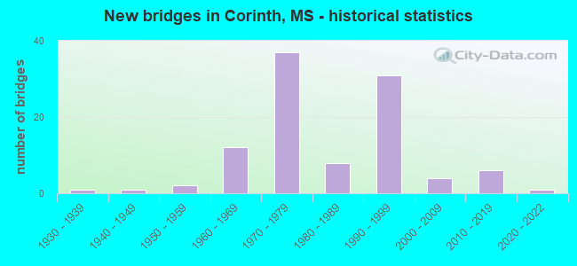
- New bridges - historical statistics
- 11930-1939
- 11940-1949
- 21950-1959
- 121960-1969
- 371970-1979
- 81980-1989
- 311990-1999
- 42000-2009
- 62010-2019
- 12020-2022
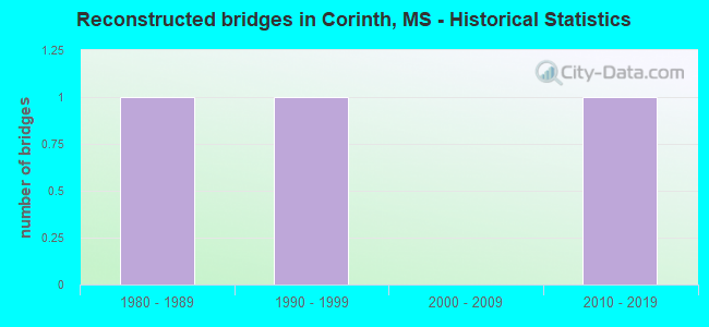
- Reconstructed bridges - Historical Statistics
- 11980-1989
- 11990-1999
- 02000-2009
- 12010-2019
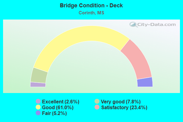
- Bridge Condition - Deck
- 2.6%Excellent
- 7.8%Very good
- 61.0%Good
- 23.4%Satisfactory
- 5.2%Fair
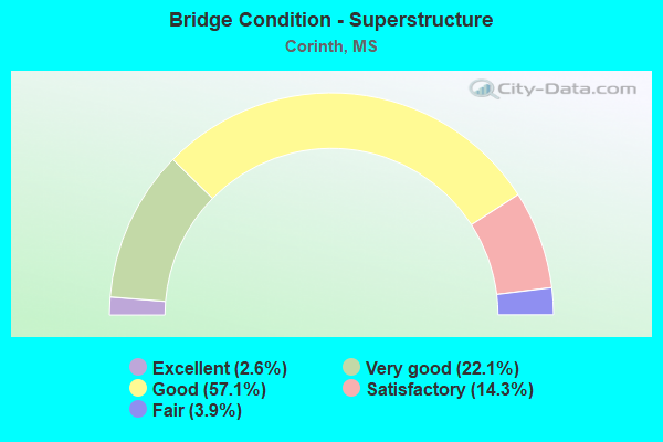
- Bridge Condition - Superstructure
- 2.6%Excellent
- 22.1%Very good
- 57.1%Good
- 14.3%Satisfactory
- 3.9%Fair
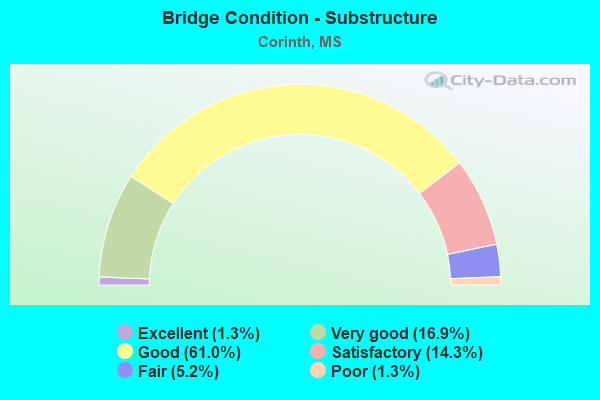
- Bridge Condition - Substructure
- 1.3%Excellent
- 16.9%Very good
- 61.0%Good
- 14.3%Satisfactory
- 5.2%Fair
- 1.3%Poor
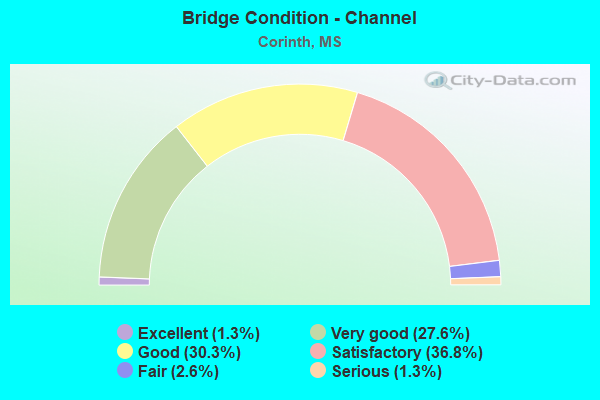
- Bridge Condition - Channel
- 1.3%Excellent
- 27.6%Very good
- 30.3%Good
- 36.8%Satisfactory
- 2.6%Fair
- 1.3%Serious
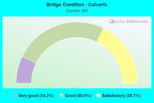
- Bridge Condition - Culverts
- 14.3%Very good
- 50.0%Good
- 35.7%Satisfactory
Find on map >> Show street view
Structure Number: SA0200000000091, Location: SEC 17 T 2S R 8E B (Lat: 34.909944, Lng: -88.480778), Route carried "on" structure: County highway 36, Year Built: 2011, Status: Open, Structure Length: 3.38m (11.09ft), Average Daily Traffic: 240 (year 2015), Truck Traffic: 8%, Average Future Daily Traffic: 360 (year 2035), Design Load: HL 93, Features Intersected: MISSISSIPPI CENTRAL RR, Facility Carried by Structure: CR 213
Minimum Vertical Clearance: 30+ m (98+ ft), Kilometerpoint: 0.160, Lanes on structure: 1, Owner: Railroad, Approaching Roadway Width: 5.5m (18.0ft), Material/Design: Concrete, Design/Construction: Channel Beam, Number Of Spans In Main Unit: 1, Number Of Approach Spans: 2, Length of Maximum Span: 12.2m (40.0ft), Curb or Sidewalk Widths: Left: 0.4m (1.3ft), Right: 0.4m (1.3ft), Curb-To-Curb Width: 5.3m (17.4ft), Out-to-Out Width: 6.1m (20.0ft)
Condition: Deck: Good, Superstructure: Good, Substructure: Satisfactory, Operating Rating: 35.3 metric tons, Method Used To Determine Operating Rating: Load and Resistance Factor Rating (LRFR) rating reported by rating factor(RF) method using HL-93 loadings, Inventory Rating: 27.2 metric tons, Method Used To Determine Inventory Rating: Load and Resistance Factor Rating (LRFR) rating reported by rating factor(RF) method using HL-93 loadings, Structural Evaluation: Equal to present minimum criteria, Deck Geometry: High priority of replacement, Underclear: Meets minimum limits, Approach Roadway Alignment: Meets minimum limits, Length Of Structure Improvement: 3.78m (12.40ft), Designated Inspection Frequency: Every 24 months, Inspection Date: Febuary 2021, Bridge Improvement Cost: $226,000, Roadway Improvement Cost: $23,000, Total Project Cost: $279,000 ( Estimate for 2016), Deck Structure Type: Concrete Precast Panels, Wearing Surface/Protective System: Wearing Surface: Monolithic Concrete
Find on map >> Show street view
Structure Number: SA0200000000096, Location: SEC 29 T 2S R 8E (Lat: 34.884722, Lng: -88.487222), Route carried "on" structure: County highway 36, Year Built: 1998, Status: Open, Structure Length: 4.70m (15.42ft), Average Daily Traffic: 210 (year 2021), Truck Traffic: 8%, Average Future Daily Traffic: 315 (year 2040), Design Load: HS 20, Features Intersected: CLEAR CREEK, Facility Carried by Structure: CR 301
Minimum Vertical Clearance: 30+ m (98+ ft), Kilometerpoint: 3.862, Lanes on structure: 2, Owner: County Highway Agency, Approaching Roadway Width: 8.5m (27.9ft), Skew: 3 degrees, Material/Design: Concrete, Design/Construction: Channel Beam, Number Of Spans In Main Unit: 5, Length of Maximum Span: 9.4m (30.8ft), Curb or Sidewalk Widths: Left: 0.5m (1.6ft), Right: 0.5m (1.6ft), Curb-To-Curb Width: 8.6m (28.2ft), Out-to-Out Width: 8.6m (28.2ft)
Condition: Deck: Good, Superstructure: Very good, Substructure: Good, Channel: Good, Operating Rating: 63.1 metric tons, Method Used To Determine Operating Rating: Load Factor (LF), Inventory Rating: 37.9 metric tons, Method Used To Determine Inventory Rating: Load Factor (LF), Structural Evaluation: Better than present minimum criteria, Deck Geometry: Equal to present minimum criteria, Waterway Adequacy: Better than present minimum criteria, Approach Roadway Alignment: Equal to present minimum criteria, Designated Inspection Frequency: Every 24 months, Inspection Date: September 2021, Deck Structure Type: Concrete Precast Panels, Wearing Surface/Protective System: Wearing Surface: Monolithic Concrete
Find on map >> Show street view
Structure Number: SA0200000000097, Location: SEC 32 T 2S R 8E B (Lat: 34.858056, Lng: -88.487500), Route carried "on" structure: County highway 1956, Year Built: 1970, Status: Posted for load, Structure Length: 3.66m (12.01ft), Average Daily Traffic: 550 (year 2015), Truck Traffic: 8%, Average Future Daily Traffic: 825 (year 2035), Design Load: HS 15, Features Intersected: TICK CREEK, Facility Carried by Structure: CR 400
Minimum Vertical Clearance: 30+ m (98+ ft), Kilometerpoint: 13.518, Lanes on structure: 2, Owner: County Highway Agency, Approaching Roadway Width: 6.4m (21.0ft), Material/Design: Steel, Design/Construction: Stringer/Multi-beam, Number Of Spans In Main Unit: 3, Length of Maximum Span: 18.3m (60.0ft), Curb or Sidewalk Widths: Left: 0.7m (2.3ft), Right: 0.7m (2.3ft), Curb-To-Curb Width: 7.3m (24.0ft), Out-to-Out Width: 8.7m (28.5ft)
Condition: Deck: Satisfactory, Superstructure: Satisfactory, Substructure: Fair, Channel: Very good, Operating Rating: 35.3 metric tons, Method Used To Determine Operating Rating: Load Factor (LF), Inventory Rating: 21.3 metric tons, Method Used To Determine Inventory Rating: Load Factor (LF), Structural Evaluation: Somewhat better than minimum adequacy, Deck Geometry: Meets minimum limits, Waterway Adequacy: Equal to present desirable criteria, Approach Roadway Alignment: Equal to present minimum criteria, Bridge Posting: Required (Relationship of Operating Rating to Maximum Legal Load: 0.1 - 9.9% below), Length Of Structure Improvement: 4.27m (14.01ft), Designated Inspection Frequency: Every 24 months, Inspection Date: November 2020, Bridge Improvement Cost: $255,000, Roadway Improvement Cost: $25,000, Total Project Cost: $314,000 ( Estimate for 2016), Deck Structure Type: Concrete Cast-file-Place, Wearing Surface/Protective System: Wearing Surface: Monolithic Concrete
Find on map >> Show street view
Structure Number: SA0200000000098, Location: SEC 32 T 2S R 8E (Lat: 34.869722, Lng: -88.472222), Route carried "on" structure: County highway 36, Year Built: 2010, Status: Open, Structure Length: 2.10m (6.89ft), Average Daily Traffic: 60 (year 2015), Truck Traffic: 8%, Average Future Daily Traffic: 90 (year 2035), Design Load: HS 20, Features Intersected: TICK CREEK, Facility Carried by Structure: CR 325
Minimum Vertical Clearance: 30+ m (98+ ft), Kilometerpoint: 6.276, Lanes on structure: 2, Owner: County Highway Agency, Approaching Roadway Width: 7.9m (25.9ft), Material/Design: Concrete, Design/Construction: Channel Beam, Number Of Spans In Main Unit: 3, Length of Maximum Span: 9.4m (30.8ft), Curb or Sidewalk Widths: Left: 0.5m (1.6ft), Right: 0.5m (1.6ft), Curb-To-Curb Width: 8.5m (27.9ft), Out-to-Out Width: 9.5m (31.2ft)
Condition: Deck: Good, Superstructure: Very good, Substructure: Very good, Channel: Very good, Operating Rating: 78.1 metric tons, Method Used To Determine Operating Rating: Load Factor (LF), Inventory Rating: 46.7 metric tons, Method Used To Determine Inventory Rating: Load Factor (LF), Structural Evaluation: Equal to present desirable criteria, Deck Geometry: Better than present minimum criteria, Waterway Adequacy: Equal to present desirable criteria, Approach Roadway Alignment: Equal to present minimum criteria, Designated Inspection Frequency: Every 24 months, Inspection Date: September 2020, Deck Structure Type: Concrete Precast Panels, Wearing Surface/Protective System: Wearing Surface: Monolithic Concrete
Find on map >> Show street view
Structure Number: SA0200000000127, Location: SEC 6 T 3S R 8E (Lat: 34.849381, Lng: -88.497094), Route carried "on" structure: County highway 121, Year Built: 1999, Status: Open, Structure Length: 4.70m (15.42ft), Average Daily Traffic: 30 (year 2021), Average Future Daily Traffic: 45 (year 2040), Design Load: HS 20, Features Intersected: TICK CREEK, Facility Carried by Structure: CR 428
Minimum Vertical Clearance: 30+ m (98+ ft), Kilometerpoint: 1.770, Lanes on structure: 2, Owner: County Highway Agency, Approaching Roadway Width: 8.5m (27.9ft), Skew: 3 degrees, Material/Design: Concrete, Design/Construction: Channel Beam, Number Of Spans In Main Unit: 5, Length of Maximum Span: 9.4m (30.8ft), Curb or Sidewalk Widths: Left: 0.5m (1.6ft), Right: 0.5m (1.6ft), Curb-To-Curb Width: 8.5m (27.9ft), Out-to-Out Width: 8.5m (27.9ft)
Condition: Deck: Good, Superstructure: Good, Substructure: Good, Channel: Satisfactory, Operating Rating: 63.1 metric tons, Method Used To Determine Operating Rating: Load Factor (LF), Inventory Rating: 37.9 metric tons, Method Used To Determine Inventory Rating: Load Factor (LF), Structural Evaluation: Better than present minimum criteria, Deck Geometry: Better than present minimum criteria, Waterway Adequacy: Equal to present desirable criteria, Approach Roadway Alignment: Equal to present minimum criteria, Designated Inspection Frequency: Every 24 months, Inspection Date: September 2021, Deck Structure Type: Concrete Precast Panels, Wearing Surface/Protective System: Wearing Surface: Monolithic Concrete
Find on map >> Show street view
Structure Number: SA0200000000159, Location: SEC 17 T 2S R 8E (Lat: 34.902389, Lng: -88.473194), Route carried "on" structure: County highway 320, Year Built: 2012, Status: Open, Structure Length: 4.88m (16.01ft), Average Daily Traffic: 1,200 (year 2015), Truck Traffic: 8%, Average Future Daily Traffic: 1,800 (year 2035), Design Load: HS 20, Features Intersected: MISSISSIPPI CENTRAL RR, Facility Carried by Structure: K.C. RD
Minimum Vertical Clearance: 30+ m (98+ ft), Kilometerpoint: 0.804, Lanes on structure: 2, Owner: County Highway Agency, Approaching Roadway Width: 7.7m (25.3ft), Material/Design: Prestressed concrete, Design/Construction: Stringer/Multi-beam, Number Of Spans In Main Unit: 1, Number Of Approach Spans: 2, Length of Maximum Span: 24.4m (80.1ft), Curb or Sidewalk Widths: Left: 0.5m (1.6ft), Right: 0.5m (1.6ft), Curb-To-Curb Width: 12.2m (40.0ft), Out-to-Out Width: 13.1m (43.0ft)
Condition: Deck: Satisfactory, Superstructure: Good, Substructure: Satisfactory, Operating Rating: 54.8 metric tons, Method Used To Determine Operating Rating: Load Factor (LF), Inventory Rating: 26.7 metric tons, Method Used To Determine Inventory Rating: Load Factor (LF), Structural Evaluation: Equal to present minimum criteria, Deck Geometry: Better than present minimum criteria, Underclear: Superior to present desirable criteria, Approach Roadway Alignment: Equal to present desirable criteria, Designated Inspection Frequency: Every 24 months, Inspection Date: Febuary 2021, Deck Structure Type: Concrete Cast-file-Place, Wearing Surface/Protective System: Wearing Surface: Monolithic Concrete
Find on map >> Show street view
Structure Number: SA020000000A013, Location: SEC 30 T 1S R 7E B (Lat: 34.964528, Lng: -88.609889), Route carried "on" structure: County highway 85, Year Built: 2016, Status: Open, Structure Length: 2.10m (6.89ft), Average Daily Traffic: 60 (year 2015), Truck Traffic: 8%, Average Future Daily Traffic: 90 (year 2035), Design Load: HL 93, Features Intersected: LITTLE CANE CREEK, Facility Carried by Structure: CR 711
Minimum Vertical Clearance: 30+ m (98+ ft), Kilometerpoint: 2.574, Lanes on structure: 2, Owner: County Highway Agency, Approaching Roadway Width: 7.9m (25.9ft), Skew: 3 degrees, Material/Design: Concrete, Design/Construction: Channel Beam, Number Of Spans In Main Unit: 3, Length of Maximum Span: 9.4m (30.8ft), Curb or Sidewalk Widths: Left: 0.5m (1.6ft), Right: 0.5m (1.6ft), Curb-To-Curb Width: 8.5m (27.9ft), Out-to-Out Width: 9.5m (31.2ft)
Condition: Deck: Excellent, Superstructure: Excellent, Substructure: Good, Channel: Very good, Operating Rating: 43.7 metric tons, Method Used To Determine Operating Rating: Load and Resistance Factor Rating (LRFR) rating reported by rating factor(RF) method using HL-93 loadings, Inventory Rating: 33.7 metric tons, Method Used To Determine Inventory Rating: Load and Resistance Factor Rating (LRFR) rating reported by rating factor(RF) method using HL-93 loadings, Structural Evaluation: Better than present minimum criteria, Deck Geometry: Better than present minimum criteria, Waterway Adequacy: Equal to present desirable criteria, Approach Roadway Alignment: Equal to present desirable criteria, Length Of Structure Improvement: 6.90m (22.64ft), Designated Inspection Frequency: Every 24 months, Inspection Date: September 2020, Deck Structure Type: Concrete Cast-file-Place, Wearing Surface/Protective System: Wearing Surface: Monolithic Concrete
Find on map >> Show street view
Structure Number: SA020000000A015, Location: SEC 31 T 1S R 7E B (Lat: 34.946500, Lng: -88.611319), Route carried "on" structure: County highway 974, Year Built: 2019, Status: Open, Structure Length: 4.94m (16.21ft), Average Daily Traffic: 150 (year 2015), Truck Traffic: 9%, Average Future Daily Traffic: 225 (year 2035), Design Load: HL 93, Features Intersected: TUSCUMBIA RIVER CANAL, Facility Carried by Structure: CR750 SMTH BRDG RD
Minimum Vertical Clearance: 30+ m (98+ ft), Kilometerpoint: 10.460, Lanes on structure: 2, Owner: County Highway Agency, Approaching Roadway Width: 8.5m (27.9ft), Material/Design: Prestressed concrete, Design/Construction: Stringer/Multi-beam, Number Of Spans In Main Unit: 1, Number Of Approach Spans: 2, Length of Maximum Span: 30.5m (100.1ft), Curb-To-Curb Width: 8.5m (27.9ft), Out-to-Out Width: 9.4m (30.8ft)
Condition: Deck: Excellent, Superstructure: Excellent, Substructure: Excellent, Channel: Excellent, Operating Rating: 50.9 metric tons, Method Used To Determine Operating Rating: Load and Resistance Factor Rating (LRFR) rating reported by rating factor(RF) method using HL-93 loadings, Inventory Rating: 35.0 metric tons, Method Used To Determine Inventory Rating: Load and Resistance Factor Rating (LRFR) rating reported by rating factor(RF) method using HL-93 loadings, Structural Evaluation: Superior to present desirable criteria, Deck Geometry: Equal to present minimum criteria, Waterway Adequacy: Equal to present desirable criteria, Approach Roadway Alignment: Equal to present desirable criteria, Designated Inspection Frequency: Every 24 months, Inspection Date: September 2020, Deck Structure Type: Concrete Cast-file-Place, Wearing Surface/Protective System: Wearing Surface: Monolithic Concrete
Find on map >> Show street view
Structure Number: SA020000000A087, Location: SEC 7 T 2S R 8E (Lat: 34.923450, Lng: -88.491592), Route carried "on" structure: County highway 95, Year Built: 2017, Status: Posted for load, Structure Length: 2.08m (6.82ft), Average Daily Traffic: 50 (year 2021), Average Future Daily Traffic: 75 (year 2040), Features Intersected: PHILLIPS CREEK, Facility Carried by Structure: CR 201
Minimum Vertical Clearance: 30+ m (98+ ft), Kilometerpoint: 1.287, Lanes on structure: 2, Owner: County Highway Agency, Approaching Roadway Width: 3.7m (12.1ft), Material/Design: Steel, Design/Construction: Box Beam or Girders - Multiple, Number Of Spans In Main Unit: 1, Length of Maximum Span: 20.1m (65.9ft), Curb or Sidewalk Widths: Left: 0.1m (0.3ft), Right: 0.1m (0.3ft), Curb-To-Curb Width: 5.2m (17.1ft), Out-to-Out Width: 5.5m (18.0ft)
Condition: Deck: Satisfactory, Superstructure: Satisfactory, Substructure: Good, Channel: Fair, Operating Rating: 24.5 metric tons, Method Used To Determine Operating Rating: Load Factor (LF), Inventory Rating: 14.7 metric tons, Method Used To Determine Inventory Rating: Load Factor (LF), Structural Evaluation: Meets minimum limits, Deck Geometry: High priority of corrective action, Waterway Adequacy: Better than present minimum criteria, Approach Roadway Alignment: Equal to present desirable criteria, Bridge Posting: Required (Relationship of Operating Rating to Maximum Legal Load: 30.0 - 39.9% below), Designated Inspection Frequency: Every 24 months, Critical Feature Inspection Frequency: Every 24 months, Inspection Date: November 2021, Critical Feature Inspection Date: November 2021, Deck Structure Type: Steel plate, Wearing Surface/Protective System: Wearing Surface: Gravel, Membrane: Preformed Fabric
Find on map >> Show street view
Structure Number: SA020000000A092, Location: SEC 17 T 2S R 8E (Lat: 34.906492, Lng: -88.473275), Route carried "on" structure: County highway 59, Year Built: 2020, Status: Open, Structure Length: 0.80m (2.62ft), Average Daily Traffic: 220 (year 2021), Truck Traffic: 8%, Average Future Daily Traffic: 300 (year 2040), Design Load: HL 93, Features Intersected: CLEAR CREEK, Facility Carried by Structure: CR 220
Minimum Vertical Clearance: 30+ m (98+ ft), Kilometerpoint: 5.310, Lanes on structure: 2, Owner: County Highway Agency, Approaching Roadway Width: 3.6m (11.8ft), Skew: 3 degrees, Material/Design: Concrete, Design/Construction: Culvert, Number Of Spans In Main Unit: 2, Length of Maximum Span: 5.6m (18.4ft)
Condition: Channel: Very good, Culverts: Very good, Operating Rating: 85.5 metric tons, Method Used To Determine Operating Rating: Load and Resistance Factor Rating (LRFR) rating reported by rating factor(RF) method using HL-93 loadings, Inventory Rating: 66.1 metric tons, Method Used To Determine Inventory Rating: Load and Resistance Factor Rating (LRFR) rating reported by rating factor(RF) method using HL-93 loadings, Structural Evaluation: Equal to present desirable criteria, Waterway Adequacy: Equal to present desirable criteria, Approach Roadway Alignment: Equal to present minimum criteria, Designated Inspection Frequency: Every 24 months, Inspection Date: September 2021, Wearing Surface/Protective System: Wearing Surface: Bituminous
Find on map >> Show street view
Structure Number: 21000720020627, Location: US 72 OVER US 45 (Lat: 34.930922, Lng: -88.547942), Route carried "under" structure: US 45, Year Built: 1972, Structure Length: 0. m, Average Daily Traffic: 4,750 (year 2017), Truck Traffic: 8%, Features Intersected: US 45, Facility Carried by Structure: US 72
Minimum Vertical Clearance: 5.61m (18.41ft), Kilometerpoint: 25.865, Lanes on structure: 4, Lanes under structure: 4, Material/Design: Prestressed concrete, Design/Construction: Stringer/Multi-beam, Length of Maximum Span: 24.4m (80.1ft)
Find on map >> Show street view
Structure Number: 21000720020627, Location: US 72 OVER US 45 (Lat: 34.930922, Lng: -88.547942), Route carried "under" structure: US 45, Year Built: 1972, Structure Length: 0. m, Average Daily Traffic: 4,750 (year 2017), Truck Traffic: 8%, Features Intersected: US 45, Facility Carried by Structure: US 72
Minimum Vertical Clearance: 5.00m (16.40ft), Kilometerpoint: 25.865, Lanes on structure: 4, Lanes under structure: 4, Material/Design: Prestressed concrete, Design/Construction: Stringer/Multi-beam, Length of Maximum Span: 24.4m (80.1ft)
Find on map >> Show street view
Structure Number: 31000020020514, Location: SR 2 OVER US 45 (Lat: 34.981850, Lng: -88.521161), Route carried "under" structure: US 45, Year Built: 1984, Structure Length: 0. m, Average Daily Traffic: 3,700 (year 2017), Truck Traffic: 8%, Features Intersected: US 45, Facility Carried by Structure: SR 2
Minimum Vertical Clearance: 5.06m (16.60ft), Kilometerpoint: 1.658, Lanes on structure: 2, Lanes under structure: 4, Material/Design: Prestressed concrete, Design/Construction: Stringer/Multi-beam, Length of Maximum Span: 28.0m (91.9ft)
Find on map >> Show street view
Structure Number: 31000020020514, Location: SR 2 OVER US 45 (Lat: 34.981850, Lng: -88.520900), Route carried "under" structure: US 45, Year Built: 1984, Structure Length: 0. m, Average Daily Traffic: 3,700 (year 2017), Truck Traffic: 8%, Features Intersected: US 45, Facility Carried by Structure: SR 2
Minimum Vertical Clearance: 5.24m (17.19ft), Kilometerpoint: 25.904, Lanes on structure: 2, Lanes under structure: 4, Material/Design: Prestressed concrete, Design/Construction: Stringer/Multi-beam, Length of Maximum Span: 28.0m (91.9ft)
Find on map >> Show street view
Structure Number: 41000450022729, Location: 10.8 MI N PRENTISS CL (Lat: 34.909078, Lng: -88.544883), Route carried "under" structure: US 45, Year Built: 1972, Structure Length: 0. m, Average Daily Traffic: 4,850 (year 2017), Truck Traffic: 8%, Features Intersected: US 45, Facility Carried by Structure: HARPER ROAD
Minimum Vertical Clearance: 5.00m (16.40ft), Kilometerpoint: 0.174, Lanes on structure: 2, Lanes under structure: 4, Material/Design: Prestressed concrete, Design/Construction: Stringer/Multi-beam, Length of Maximum Span: 24.4m (80.1ft)
Find on map >> Show street view
Structure Number: 41000450022729, Location: 10.8 MI N PRENTISS CL (Lat: 34.909078, Lng: -88.544883), Route carried "under" structure: US 45, Year Built: 1972, Structure Length: 0. m, Average Daily Traffic: 8,500 (year 2017), Truck Traffic: 8%, Features Intersected: US 45, Facility Carried by Structure: HARPER ROAD
Minimum Vertical Clearance: 4.82m (15.81ft), Kilometerpoint: 0.174, Lanes on structure: 2, Lanes under structure: 4, Material/Design: Prestressed concrete, Design/Construction: Stringer/Multi-beam, Length of Maximum Span: 24.4m (80.1ft)
Find on map >> Show street view
Structure Number: 4100045002274, Location: 11.8 MI N PRENTISS CL (Lat: 34.924169, Lng: -88.543994), Route carried "under" structure: US 45, Year Built: 1972, Structure Length: 0. m, Average Daily Traffic: 4,850 (year 2017), Truck Traffic: 8%, Features Intersected: US 45, Facility Carried by Structure: BELL SCHOOL ROAD
Minimum Vertical Clearance: 5.06m (16.60ft), Kilometerpoint: 0.787, Lanes on structure: 2, Lanes under structure: 4, Material/Design: Prestressed concrete, Design/Construction: Stringer/Multi-beam, Length of Maximum Span: 24.4m (80.1ft)
Find on map >> Show street view
Structure Number: 4100045002274, Location: 11.8 MI N PRENTISS CL (Lat: 34.924169, Lng: -88.543994), Route carried "under" structure: US 45, Year Built: 1972, Structure Length: 0. m, Average Daily Traffic: 4,850 (year 2017), Truck Traffic: 8%, Features Intersected: US 45, Facility Carried by Structure: BELL SCHOOL ROAD
Minimum Vertical Clearance: 4.97m (16.31ft), Kilometerpoint: 0.787, Lanes on structure: 2, Lanes under structure: 4, Material/Design: Prestressed concrete, Design/Construction: Stringer/Multi-beam, Length of Maximum Span: 24.4m (80.1ft)
Find on map >> Show street view
Structure Number: 41000450022743, Location: 12.1 MI N PRENTISS CL (Lat: 34.928003, Lng: -88.547331), Route carried "under" structure: US 45, Year Built: 1972, Structure Length: 0. m, Average Daily Traffic: 4,850 (year 2017), Truck Traffic: 8%, Features Intersected: US 45, Facility Carried by Structure: KOSSUTH ROAD
Minimum Vertical Clearance: 5.21m (17.09ft), Kilometerpoint: 1.793, Lanes on structure: 2, Lanes under structure: 4, Material/Design: Steel continuous, Design/Construction: Stringer/Multi-beam, Length of Maximum Span: 33.5m (109.9ft)
Find on map >> Show street view
Structure Number: 41000450022743, Location: 12.1 MI N PRENTISS CL (Lat: 34.928003, Lng: -88.547331), Route carried "under" structure: US 45, Year Built: 1972, Structure Length: 0. m, Average Daily Traffic: 4,850 (year 2017), Truck Traffic: 8%, Features Intersected: US 45, Facility Carried by Structure: KOSSUTH ROAD
Minimum Vertical Clearance: 5.85m (19.19ft), Kilometerpoint: 1.793, Lanes on structure: 2, Lanes under structure: 4, Material/Design: Steel continuous, Design/Construction: Stringer/Multi-beam, Length of Maximum Span: 33.5m (109.9ft)
Find on map >> Show street view
Structure Number: 4100045002275, Location: 0.5 MI N US 72 (Lat: 34.938247, Lng: -88.545642), Route carried "under" structure: US 45, Year Built: 1965, Structure Length: 0. m, Average Daily Traffic: 5,500 (year 2017), Truck Traffic: 8%, Features Intersected: US 45, Facility Carried by Structure: SMITH BRIDGE ROAD
Minimum Vertical Clearance: 5.15m (16.90ft), Kilometerpoint: 1.184, Lanes on structure: 2, Lanes under structure: 4, Material/Design: Prestressed concrete, Design/Construction: Stringer/Multi-beam, Length of Maximum Span: 18.3m (60.0ft)
Find on map >> Show street view
Structure Number: 4100045002275, Location: 0.5 MI N US 72 (Lat: 34.938247, Lng: -88.545642), Route carried "under" structure: US 45, Year Built: 1965, Structure Length: 0. m, Average Daily Traffic: 5,500 (year 2017), Truck Traffic: 8%, Features Intersected: US 45, Facility Carried by Structure: SMITH BRIDGE ROAD
Minimum Vertical Clearance: 5.09m (16.70ft), Kilometerpoint: 1.184, Lanes on structure: 2, Lanes under structure: 4, Material/Design: Prestressed concrete, Design/Construction: Stringer/Multi-beam, Length of Maximum Span: 18.3m (60.0ft)