Bridge Statistics for Clarksville, Tennessee (TN)
Condition, Traffic, Stress, Structural Evaluation, Project Costs
- National Bridge Inventory (NBI) Statistics
- 110Number of bridges
- 1,916ft / 584mTotal length
- $99,889,000Total costs
- 2,179,698Total average daily traffic
- 326,667Total average daily truck traffic
- National Bridge Inventory (NBI) Registered Bridges for Clarksville
- No street view available for this location
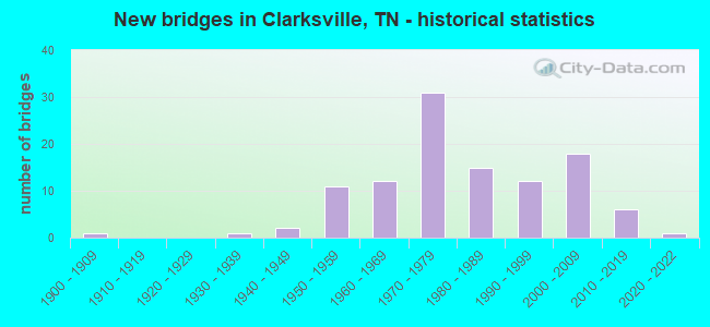
- New bridges - historical statistics
- 11900-1909
- 11930-1939
- 21940-1949
- 111950-1959
- 121960-1969
- 311970-1979
- 151980-1989
- 121990-1999
- 182000-2009
- 62010-2019
- 12020-2022

- Reconstructed bridges - Historical Statistics
- 21970-1979
- 11980-1989
- 21990-1999
- 22000-2009


- Bridge Condition - Deck
- 18.6%Very good
- 44.3%Good
- 22.9%Satisfactory
- 11.4%Fair
- 2.9%Poor

- Bridge Condition - Superstructure
- 9.9%Very good
- 33.8%Good
- 28.2%Satisfactory
- 25.4%Fair
- 2.8%Poor

- Bridge Condition - Substructure
- 15.5%Very good
- 46.5%Good
- 18.3%Satisfactory
- 16.9%Fair
- 1.4%Poor
- 1.4%Serious

- Bridge Condition - Channel
- 10.2%Very good
- 52.5%Good
- 15.3%Satisfactory
- 16.9%Fair
- 5.1%Poor

- Bridge Condition - Culverts
- 6.7%Very good
- 33.3%Good
- 33.3%Satisfactory
- 20.0%Fair
- 6.7%Poor
Find on map >> Show street view
Structure Number: DAPFORCAT000026, Location: 540-522 (Lat: 36.616350, Lng: -87.514339), Route carried "on" structure: Other road , Year Built: 1968, Status: Closed, Structure Length: 4.02m (13.19ft), Average Daily Traffic: 500 (year 2020), Truck Traffic: 40%, Average Future Daily Traffic: 500 (year 2042), Features Intersected: PINEY FORK CREEK, Facility Carried by Structure: BOILING SPRINGS RD
Minimum Vertical Clearance: 30+ m (98+ ft), Kilometerpoint: 0.000, Lanes on structure: 2, Owner: Army, Approaching Roadway Width: 6.1m (20.0ft), Material/Design: Concrete, Design/Construction: Tee Beam, Number Of Spans In Main Unit: 4, Length of Maximum Span: 10.2m (33.5ft), Curb or Sidewalk Widths: Left: 0.4m (1.3ft), Right: 0.4m (1.3ft), Curb-To-Curb Width: 7.2m (23.6ft), Out-to-Out Width: 8.0m (26.2ft)
Condition: Deck: Satisfactory, Superstructure: Fair, Substructure: Poor, Channel: Poor, Operating Rating: 42.4 metric tons, Method Used To Determine Operating Rating: Field evaluation and documented engineering judgment, Inventory Rating: 32.7 metric tons, Method Used To Determine Inventory Rating: Field evaluation and documented engineering judgment, Structural Evaluation: Meets minimum limits, Deck Geometry: Meets minimum limits, Waterway Adequacy: Equal to present minimum criteria, Approach Roadway Alignment: Equal to present minimum criteria, Length Of Structure Improvement: 4.98m (16.34ft), Designated Inspection Frequency: Every 24 months, Inspection Date: October 2020, Bridge Improvement Cost: $6,000, Roadway Improvement Cost: $34,000, Total Project Cost: $40,000 ( Estimate for 2020), Deck Structure Type: Concrete Cast-file-Place, Wearing Surface/Protective System: Wearing Surface: Bituminous
Find on map >> Show street view
Structure Number: DAPFORCAT000031, Location: 0.3 MI S WILLIAM C LEE RD (Lat: 36.607631, Lng: -87.448650), Route carried "on" structure: Other road , Year Built: 1981, Status: Open, Structure Length: 7.80m (25.59ft), Average Daily Traffic: 1,000 (year 2018), Truck Traffic: 10%, Average Future Daily Traffic: 1,000 (year 2042), Design Load: HS 20, Features Intersected: LITTLE WEST FORK CREEK, Facility Carried by Structure: 101ST AIRBORN D RD
Minimum Vertical Clearance: 30+ m (98+ ft), Kilometerpoint: 0.000, Lanes on structure: 2, Owner: Army, Approaching Roadway Width: 13.9m (45.6ft), Material/Design: Prestressed concrete, Design/Construction: Stringer/Multi-beam, Number Of Spans In Main Unit: 4, Length of Maximum Span: 19.5m (64.0ft), Curb or Sidewalk Widths: Left: 1.5m (4.9ft), Right: 0.0m, Curb-To-Curb Width: 13.4m (44.0ft), Out-to-Out Width: 16.2m (53.1ft)
Condition: Deck: Good, Superstructure: Satisfactory, Substructure: Good, Channel: Good, Operating Rating: 42.4 metric tons, Method Used To Determine Operating Rating: Field evaluation and documented engineering judgment, Inventory Rating: 32.7 metric tons, Method Used To Determine Inventory Rating: Field evaluation and documented engineering judgment, Structural Evaluation: Equal to present minimum criteria, Deck Geometry: Superior to present desirable criteria, Waterway Adequacy: Equal to present desirable criteria, Approach Roadway Alignment: Equal to present desirable criteria, Length Of Structure Improvement: 8.81m (28.90ft), Designated Inspection Frequency: Every 24 months, Inspection Date: October 2020, Bridge Improvement Cost: $1,000, Roadway Improvement Cost: $1,000, Total Project Cost: $2,000 ( Estimate for 2020), Deck Structure Type: Concrete Cast-file-Place, Wearing Surface/Protective System: Wearing Surface: Monolithic Concrete
Find on map >> Show street view
Structure Number: DAPFORCAT000033, Location: 597-512 (Lat: 36.607769, Lng: -87.449650), Route carried "on" structure: Other road , Year Built: 1950, Status: Open, Structure Length: 8.29m (27.20ft), Average Daily Traffic: 100 (year 2018), Truck Traffic: 4%, Average Future Daily Traffic: 100 (year 2042), Features Intersected: LITTLE WEST FORK CREEK, Facility Carried by Structure: FENCE PATROL ROAD
Minimum Vertical Clearance: 30+ m (98+ ft), Kilometerpoint: 0.000, Lanes on structure: 1, Owner: Army, Approaching Roadway Width: 4.5m (14.8ft), Material/Design: Concrete, Design/Construction: Tee Beam, Number Of Spans In Main Unit: 8, Length of Maximum Span: 11.5m (37.7ft), Curb-To-Curb Width: 7.9m (25.9ft), Out-to-Out Width: 19.0m (62.3ft)
Condition: Deck: Fair, Superstructure: Fair, Substructure: Satisfactory, Channel: Satisfactory, Operating Rating: 42.4 metric tons, Method Used To Determine Operating Rating: Field evaluation and documented engineering judgment, Inventory Rating: 32.7 metric tons, Method Used To Determine Inventory Rating: Field evaluation and documented engineering judgment, Structural Evaluation: Somewhat better than minimum adequacy, Deck Geometry: Equal to present minimum criteria, Waterway Adequacy: Equal to present desirable criteria, Approach Roadway Alignment: Equal to present minimum criteria, Length Of Structure Improvement: 9.75m (31.99ft), Designated Inspection Frequency: Every 24 months, Underwater Inspection Frequency: Every 60 months, Inspection Date: October 2020, Underwater Inspection Date: November 2018, Bridge Improvement Cost: $1,000, Roadway Improvement Cost: $1,000, Total Project Cost: $2,000 ( Estimate for 2020), Deck Structure Type: Concrete Cast-file-Place, Wearing Surface/Protective System: Wearing Surface: Monolithic Concrete
Find on map >> Show street view
Structure Number: DAPFORCAT000034, Location: 0.5 MI S OF MABRY RD (Lat: 36.610511, Lng: -87.469800), Route carried "on" structure: Other road , Year Built: 1950, Year Reconstructed: 2007, Status: Open, Structure Length: 10.31m (33.83ft), Average Daily Traffic: 300 (year 2018), Truck Traffic: 40%, Average Future Daily Traffic: 300 (year 2042), Features Intersected: LITTLE WEST FORK CREEK, Facility Carried by Structure: EAST END ROAD
Minimum Vertical Clearance: 30+ m (98+ ft), Kilometerpoint: 0.000, Lanes on structure: 2, Owner: Army, Approaching Roadway Width: 6.7m (22.0ft), Material/Design: Concrete, Design/Construction: Tee Beam, Number Of Spans In Main Unit: 8, Length of Maximum Span: 13.1m (43.0ft), Curb or Sidewalk Widths: Left: 0.4m (1.3ft), Right: 0.4m (1.3ft), Curb-To-Curb Width: 6.8m (22.3ft), Out-to-Out Width: 7.7m (25.3ft)
Condition: Deck: Fair, Superstructure: Fair, Substructure: Satisfactory, Channel: Satisfactory, Operating Rating: 28.1 metric tons, Method Used To Determine Operating Rating: Field evaluation and documented engineering judgment, Inventory Rating: 21.6 metric tons, Method Used To Determine Inventory Rating: Field evaluation and documented engineering judgment, Structural Evaluation: Somewhat better than minimum adequacy, Deck Geometry: Meets minimum limits, Waterway Adequacy: Equal to present minimum criteria, Approach Roadway Alignment: Equal to present minimum criteria, Bridge Posting: Required (Relationship of Operating Rating to Maximum Legal Load: 30.0 - 39.9% below), Length Of Structure Improvement: 11.23m (36.84ft), Designated Inspection Frequency: Every 24 months, Underwater Inspection Frequency: Every 60 months, Inspection Date: October 2020, Underwater Inspection Date: November 2018, Bridge Improvement Cost: $1,000, Roadway Improvement Cost: $1,000, Total Project Cost: $2,000 ( Estimate for 2020), Deck Structure Type: Concrete Cast-file-Place, Wearing Surface/Protective System: Wearing Surface: Bituminous
Find on map >> Show street view
Structure Number: DAPFORCAT000035, Location: 556-519 (Lat: 36.613119, Lng: -87.495911), Route carried "on" structure: Other road , Year Built: 1960, Status: Open, Structure Length: 2.35m (7.71ft), Average Daily Traffic: 300 (year 2020), Truck Traffic: 40%, Average Future Daily Traffic: 300 (year 2042), Features Intersected: LITTLE WEST FORK CREEK, Facility Carried by Structure: WEST END RD
Minimum Vertical Clearance: 30+ m (98+ ft), Kilometerpoint: 0.000, Lanes on structure: 2, Owner: Army, Approaching Roadway Width: 6.4m (21.0ft), Material/Design: Concrete, Design/Construction: Tee Beam, Number Of Spans In Main Unit: 2, Length of Maximum Span: 11.0m (36.1ft), Curb-To-Curb Width: 6.7m (22.0ft), Out-to-Out Width: 7.6m (24.9ft)
Condition: Deck: Satisfactory, Superstructure: Fair, Substructure: Satisfactory, Channel: Fair, Operating Rating: 42.4 metric tons, Method Used To Determine Operating Rating: Field evaluation and documented engineering judgment, Inventory Rating: 32.7 metric tons, Method Used To Determine Inventory Rating: Field evaluation and documented engineering judgment, Structural Evaluation: Somewhat better than minimum adequacy, Deck Geometry: Meets minimum limits, Waterway Adequacy: Equal to present minimum criteria, Approach Roadway Alignment: Equal to present desirable criteria, Length Of Structure Improvement: 3.19m (10.47ft), Designated Inspection Frequency: Every 24 months, Inspection Date: October 2020, Bridge Improvement Cost: $1,000, Roadway Improvement Cost: $1,000, Total Project Cost: $2,000 ( Estimate for 2020), Deck Structure Type: Concrete Cast-file-Place, Wearing Surface/Protective System: Wearing Surface: Monolithic Concrete
Find on map >> Show street view
Structure Number: DAPFORCAT000036, Location: 0.5 MI S MABRY/MCNAIR RD (Lat: 36.613081, Lng: -87.497011), Route carried "on" structure: Other road , Year Built: 1950, Status: Open, Structure Length: 3.32m (10.89ft), Average Daily Traffic: 300 (year 2018), Truck Traffic: 40%, Average Future Daily Traffic: 300 (year 2042), Features Intersected: LITTLE WEST FORK CREEK, Facility Carried by Structure: MCNAIR ROAD
Minimum Vertical Clearance: 30+ m (98+ ft), Kilometerpoint: 0.000, Lanes on structure: 1, Owner: Army, Approaching Roadway Width: 5.2m (17.1ft), Design/Construction: Arch - Deck, Number Of Spans In Main Unit: 4, Length of Maximum Span: 7.0m (23.0ft), Curb or Sidewalk Widths: Left: 0.3m (1.0ft), Right: 0.3m (1.0ft), Curb-To-Curb Width: 5.0m (16.4ft), Out-to-Out Width: 5.6m (18.4ft)
Condition: Superstructure: Satisfactory, Substructure: Fair, Channel: Fair, Operating Rating: 55.1 metric tons, Method Used To Determine Operating Rating: Load and Resistance Factor Rating (LRFR) rating reported by rating factor(RF) method using HL-93 loadings, Inventory Rating: 42.4 metric tons, Method Used To Determine Inventory Rating: Load and Resistance Factor Rating (LRFR) rating reported by rating factor(RF) method using HL-93 loadings, Structural Evaluation: Somewhat better than minimum adequacy, Deck Geometry: High priority of replacement, Waterway Adequacy: Equal to present minimum criteria, Approach Roadway Alignment: Equal to present desirable criteria, Bridge Posting: Required (Relationship of Operating Rating to Maximum Legal Load: 0.1 - 9.9% below), Length Of Structure Improvement: 4.20m (13.78ft), Designated Inspection Frequency: Every 24 months, Inspection Date: October 2020, Bridge Improvement Cost: $1,000, Roadway Improvement Cost: $1,000, Total Project Cost: $2,000 ( Estimate for 2020), Wearing Surface/Protective System: Wearing Surface: Gravel
Find on map >> Show street view
Structure Number: DAPFORCAT000037, Location: 0.5 MI S MABRY/FENCE PATR (Lat: 36.613131, Lng: -87.496211), Route carried "on" structure: Other road , Year Built: 1953, Status: Open, Structure Length: 20.09m (65.91ft), Average Daily Traffic: 100 (year 2020), Truck Traffic: 40%, Average Future Daily Traffic: 100 (year 2042), Features Intersected: LITTLE WEST FORK CREEK, Facility Carried by Structure: FENCE PATROL ROAD
Minimum Vertical Clearance: 30+ m (98+ ft), Kilometerpoint: 0.000, Lanes on structure: 1, Owner: Army, Approaching Roadway Width: 6.1m (20.0ft), Material/Design: Concrete, Design/Construction: Tee Beam, Number Of Spans In Main Unit: 17, Length of Maximum Span: 12.2m (40.0ft), Curb or Sidewalk Widths: Left: 0.5m (1.6ft), Right: 0.5m (1.6ft), Curb-To-Curb Width: 11.0m (36.1ft), Out-to-Out Width: 19.0m (62.3ft)
Condition: Deck: Fair, Superstructure: Fair, Substructure: Fair, Channel: Fair, Operating Rating: 42.4 metric tons, Method Used To Determine Operating Rating: Field evaluation and documented engineering judgment, Inventory Rating: 32.7 metric tons, Method Used To Determine Inventory Rating: Field evaluation and documented engineering judgment, Structural Evaluation: Somewhat better than minimum adequacy, Deck Geometry: Superior to present desirable criteria, Waterway Adequacy: Better than present minimum criteria, Approach Roadway Alignment: Equal to present desirable criteria, Length Of Structure Improvement: 20.60m (67.59ft), Designated Inspection Frequency: Every 24 months, Inspection Date: October 2020, Bridge Improvement Cost: $102,000, Roadway Improvement Cost: $65,000, Total Project Cost: $167,000 ( Estimate for 2020), Deck Structure Type: Concrete Cast-file-Place, Wearing Surface/Protective System: Wearing Surface: Monolithic Concrete
Find on map >> Show street view
Structure Number: DAPFORCAT000041, Location: 540-529 (Lat: 36.622250, Lng: -87.513039), Route carried "on" structure: Other road , Year Built: 1980, Status: Open, Structure Length: 4.08m (13.39ft), Average Daily Traffic: 300 (year 2020), Truck Traffic: 40%, Average Future Daily Traffic: 300 (year 2042), Features Intersected: DRY FORK CREEK, Facility Carried by Structure: MABRY ROAD
Minimum Vertical Clearance: 30+ m (98+ ft), Kilometerpoint: 0.000, Lanes on structure: 2, Owner: Army, Approaching Roadway Width: 9.4m (30.8ft), Material/Design: Steel, Design/Construction: Culvert, Number Of Spans In Main Unit: 8, Length of Maximum Span: 4.6m (15.1ft), Curb or Sidewalk Widths: Left: 0.0m, Right: 1.2m (3.9ft)
Condition: Channel: Poor, Culverts: Fair, Operating Rating: 97.2 metric tons, Method Used To Determine Operating Rating: Load and Resistance Factor Rating (LRFR) rating reported by rating factor(RF) method using HL-93 loadings, Inventory Rating: 92.0 metric tons, Method Used To Determine Inventory Rating: Load and Resistance Factor Rating (LRFR) rating reported by rating factor(RF) method using HL-93 loadings, Structural Evaluation: Somewhat better than minimum adequacy, Waterway Adequacy: Equal to present minimum criteria, Approach Roadway Alignment: Equal to present desirable criteria, Length Of Structure Improvement: 5.12m (16.80ft), Designated Inspection Frequency: Every 24 months, Inspection Date: October 2020, Bridge Improvement Cost: $1,000, Roadway Improvement Cost: $1,000, Total Project Cost: $2,000 ( Estimate for 2020)
Find on map >> Show street view
Structure Number: 63031340001, Location: ON COMMERCE ST (Lat: 36.525617, Lng: -87.361633), Route carried "under" structure: City street 3134, Year Built: 1950, Structure Length: 0. m, Average Daily Traffic: 3,215 (year 2020), Truck Traffic: 3%, Features Intersected: PED WALKWAY/COMMERCE ST, Facility Carried by Structure: PED. WALKWAY
Minimum Vertical Clearance: 7.11m (23.33ft), Kilometerpoint: 1.416, Lanes under structure: 2, Material/Design: Steel, Design/Construction: Truss - Thru, Length of Maximum Span: 40.5m (132.9ft)
Find on map >> Show street view
Structure Number: 63I00240001, Location: 1.5 MI.SE TN.ST.LN. (Lat: 36.629467, Lng: -87.317100), Route carried "under" structure: Interstate 24, Year Built: 1975, Structure Length: 0. m, Average Daily Traffic: 54,336 (year 2020), Truck Traffic: 35%, Features Intersected: SR 48 / I24, Facility Carried by Structure: FAS 48
Minimum Vertical Clearance: 5.00m (16.40ft), Kilometerpoint: 2.462, Lanes on structure: 4, Lanes under structure: 4, Material/Design: Concrete continuous, Design/Construction: Box Beam or Girders - Multiple, Length of Maximum Span: 36.6m (120.1ft)
Find on map >> Show street view
Structure Number: 63I00240003, Location: 5 MI.S.OF KY.LN. (Lat: 36.616667, Lng: -87.300000), Route carried "under" structure: Interstate 24, Year Built: 1972, Structure Length: 0. m, Average Daily Traffic: 54,336 (year 2020), Truck Traffic: 26%, Features Intersected: MERIWEATHER RD./I 24, Facility Carried by Structure: NFA A236
Minimum Vertical Clearance: 5.06m (16.60ft), Kilometerpoint: 4.587, Lanes on structure: 2, Lanes under structure: 2, Material/Design: Steel continuous, Design/Construction: Stringer/Multi-beam, Length of Maximum Span: 48.8m (160.1ft)
Find on map >> Show street view
Structure Number: 63I00240007, Location: 5 MI.NE. OF CLARKSVILLE (Lat: 36.599917, Lng: -87.283100), Route carried "under" structure: US 79, Year Built: 1972, Structure Length: 0. m, Average Daily Traffic: 27,580 (year 2020), Truck Traffic: 9%, Features Intersected: I24 RL / SR 13, Facility Carried by Structure: I24
Minimum Vertical Clearance: 4.98m (16.34ft), Kilometerpoint: 42.728, Lanes on structure: 3, Lanes under structure: 4, Material/Design: Prestressed concrete continuous, Design/Construction: Box Beam or Girders - Single/Spread, Length of Maximum Span: 29.3m (96.1ft)
Find on map >> Show street view
Structure Number: 63I00240008, Location: I24 - SR 13 INTERCHANGE (Lat: 36.600350, Lng: -87.282600), Route carried "under" structure: US 79, Year Built: 1972, Structure Length: 0. m, Average Daily Traffic: 8,595 (year 2020), Truck Traffic: 7%, Features Intersected: I24 LL / SR 13, Facility Carried by Structure: I24
Minimum Vertical Clearance: 5.01m (16.44ft), Kilometerpoint: 42.793, Lanes on structure: 3, Lanes under structure: 4, Material/Design: Prestressed concrete continuous, Design/Construction: Box Beam or Girders - Single/Spread, Length of Maximum Span: 29.3m (96.1ft)
Find on map >> Show street view
Structure Number: 63I00240011, Location: 6.1 MI.SE KENTUCKY ST.LN. (Lat: 36.579033, Lng: -87.265367), Route carried "under" structure: Interstate 24, Year Built: 1972, Structure Length: 0. m, Average Daily Traffic: 59,314 (year 2020), Truck Traffic: 26%, Features Intersected: DUNLOP RD. / I24, Facility Carried by Structure: NFA 1882 (SA 6325)
Minimum Vertical Clearance: 4.98m (16.34ft), Kilometerpoint: 9.833, Lanes on structure: 2, Lanes under structure: 4, Material/Design: Concrete continuous, Design/Construction: Box Beam or Girders - Multiple, Length of Maximum Span: 36.3m (119.1ft)
Find on map >> Show street view
Structure Number: 63I00240015, Location: 3.1 MI.E.OF CLARKSVILLE (Lat: 36.525433, Lng: -87.221883), Route carried "under" structure: State highway 76, Year Built: 1973, Structure Length: 0. m, Average Daily Traffic: 24,891 (year 2020), Truck Traffic: 9%, Features Intersected: I24 RL / SR 76, Facility Carried by Structure: I24
Minimum Vertical Clearance: 4.93m (16.17ft), Kilometerpoint: 28.405, Lanes on structure: 2, Lanes under structure: 4, Material/Design: Concrete continuous, Design/Construction: Box Beam or Girders - Multiple, Length of Maximum Span: 35.4m (116.1ft)
Find on map >> Show street view
Structure Number: 63I00240016, Location: 3 MI.E.OF CLARKSVILLE (Lat: 36.525783, Lng: -87.221183), Route carried "under" structure: State highway 76, Year Built: 1973, Structure Length: 0. m, Average Daily Traffic: 7,093 (year 2020), Truck Traffic: 4%, Features Intersected: I24 LL / SR 76, Facility Carried by Structure: I24
Minimum Vertical Clearance: 4.95m (16.24ft), Kilometerpoint: 28.485, Lanes on structure: 2, Lanes under structure: 4, Material/Design: Concrete continuous, Design/Construction: Box Beam or Girders - Multiple, Length of Maximum Span: 35.4m (116.1ft)
Find on map >> Show street view
Structure Number: 63I00240017, Location: NEAR SANGO (Lat: 36.514133, Lng: -87.208267), Route carried "under" structure: Interstate 24, Year Built: 1973, Structure Length: 0. m, Average Daily Traffic: 55,227 (year 2020), Truck Traffic: 20%, Features Intersected: TROUGH SPRINGS RD. / I24, Facility Carried by Structure: NFA 1880 (SA 6320)
Minimum Vertical Clearance: 4.93m (16.17ft), Kilometerpoint: 18.862, Lanes on structure: 2, Lanes under structure: 4, Material/Design: Concrete continuous, Design/Construction: Box Beam or Girders - Multiple, Length of Maximum Span: 32.9m (107.9ft)
Find on map >> Show street view
Structure Number: 63I00240018, Location: NEAR SANGO (Lat: 36.514517, Lng: -87.206833), Route carried "under" structure: Interstate 24, Year Built: 1973, Structure Length: 0. m, Average Daily Traffic: 55,227 (year 2020), Truck Traffic: 20%, Features Intersected: TROUGH SPRINGS RD. / I24, Facility Carried by Structure: NFA 1880 (SA 6320)
Minimum Vertical Clearance: 4.88m (16.01ft), Kilometerpoint: 18.910, Lanes on structure: 2, Lanes under structure: 4, Material/Design: Concrete continuous, Design/Construction: Box Beam or Girders - Multiple, Length of Maximum Span: 32.9m (107.9ft)
Find on map >> Show street view
Structure Number: 63I00240019, Location: A281 - I24 INTERCHANGE (Lat: 36.495917, Lng: -87.176733), Route carried "under" structure: Interstate 24, Year Built: 1970, Structure Length: 0. m, Average Daily Traffic: 55,227 (year 2020), Truck Traffic: 20%, Features Intersected: DURHAM RD./I24, Facility Carried by Structure: NFA A281
Minimum Vertical Clearance: 4.88m (16.01ft), Kilometerpoint: 22.306, Lanes on structure: 2, Lanes under structure: 4, Material/Design: Concrete continuous, Design/Construction: Box Beam or Girders - Multiple, Length of Maximum Span: 30.5m (100.1ft)
Find on map >> Show street view
Structure Number: 63I00240025, Location: 1.25 MI.N.OF RED RIVER (Lat: 36.555767, Lng: -87.250433), Route carried "under" structure: Interstate 24, Year Built: 1973, Structure Length: 0. m, Average Daily Traffic: 59,314 (year 2020), Truck Traffic: 26%, Features Intersected: ROSSVIEW RD./I24, Facility Carried by Structure: FAS 237
Minimum Vertical Clearance: 5.16m (16.93ft), Kilometerpoint: 12.794, Lanes on structure: 2, Lanes under structure: 2, Material/Design: Concrete continuous, Design/Construction: Frame, Length of Maximum Span: 27.4m (89.9ft)
Find on map >> Show street view
Structure Number: 63I00240026, Location: 8 MI.SE.OF KENTUCKY ST.LN (Lat: 36.556367, Lng: -87.248517), Route carried "under" structure: Interstate 24, Year Built: 1973, Structure Length: 0. m, Average Daily Traffic: 59,314 (year 2020), Truck Traffic: 26%, Features Intersected: ROSSVIEW RD. / I24, Facility Carried by Structure: FAS 237
Minimum Vertical Clearance: 5.08m (16.67ft), Kilometerpoint: 12.794, Lanes on structure: 2, Lanes under structure: 3, Material/Design: Concrete continuous, Design/Construction: Frame, Length of Maximum Span: 27.4m (89.9ft)
Find on map >> Show street view
Structure Number: 63SR0120011, Location: NEAR CLARKSVILLE TN (Lat: 36.522450, Lng: -87.363433), Route carried "under" structure: State highway 12, Year Built: 1962, Structure Length: 0. m, Average Daily Traffic: 29,245 (year 2020), Truck Traffic: 9%, Features Intersected: CSX RR / SR-12, Facility Carried by Structure: CSX RR 348177G
Minimum Vertical Clearance: 5.36m (17.59ft), Kilometerpoint: 22.467, Lanes under structure: 4, Material/Design: Concrete, Design/Construction: Arch - Deck, Length of Maximum Span: 59.7m (195.9ft)
Find on map >> Show street view
Structure Number: 63SR0120017, Location: NEAR CLARKSVILLE TENN. (Lat: 36.620483, Lng: -87.431467), Route carried "under" structure: Alternate US 41, Year Built: 1996, Structure Length: 0. m, Average Daily Traffic: 34,034 (year 2020), Truck Traffic: 9%, Features Intersected: IC RR / SR 12, Facility Carried by Structure: IC RR 298323V
Minimum Vertical Clearance: 4.90m (16.08ft), Kilometerpoint: 35.921, Lanes under structure: 7, Material/Design: Steel, Design/Construction: Stringer/Multi-beam, Length of Maximum Span: 31.1m (102.0ft)
Find on map >> Show street view
Structure Number: 63SR0120019, Location: IN CLARKSVILLE (Lat: 36.585133, Lng: -87.411567), Route carried "under" structure: State highway 12, Year Built: 1992, Structure Length: 0. m, Average Daily Traffic: 25,627 (year 2020), Truck Traffic: 9%, Features Intersected: NORTH PKWY. / SR 12, Facility Carried by Structure: FAP 374
Minimum Vertical Clearance: 5.26m (17.26ft), Kilometerpoint: 31.543, Lanes on structure: 1, Lanes under structure: 6, Material/Design: Prestressed concrete continuous, Design/Construction: Box Beam or Girders - Single/Spread, Length of Maximum Span: 22.9m (75.1ft)
Find on map >> Show street view
Structure Number: 63SR0120021, Location: NEAR CLARKSVILLE TN (Lat: 36.529050, Lng: -87.363333), Route carried "under" structure: State highway 12, Year Built: 2006, Structure Length: 0. m, Average Daily Traffic: 29,245 (year 2020), Truck Traffic: 9%, Features Intersected: PED. WALKWAY / SR-12, Facility Carried by Structure: PED. WALKWAY
Minimum Vertical Clearance: 5.39m (17.68ft), Kilometerpoint: 23.223, Lanes under structure: 4, Material/Design: Steel continuous, Design/Construction: Stringer/Multi-beam, Length of Maximum Span: 36.6m (120.1ft)
Find on map >> Show street view
Structure Number: 63SR0130007, Location: .4 MI N JCT SR149&SR13 (Lat: 36.480317, Lng: -87.374933), Route carried "under" structure: County highway 971, Year Built: 1965, Structure Length: 0. m, Average Daily Traffic: 2,256 (year 2020), Truck Traffic: 3%, Features Intersected: RIVER RD-CUMBERLAND RIVE, Facility Carried by Structure: FAP 13
Minimum Vertical Clearance: 6.99m (22.93ft), Kilometerpoint: 17.349, Lanes on structure: 2, Lanes under structure: 2, Material/Design: Steel continuous, Design/Construction: Stringer/Multi-beam, Length of Maximum Span: 121.9m (399.9ft)
Find on map >> Show street view
Structure Number: 63SR0130021, Location: 5 MI.NE. OF CLARKSVILLE (Lat: 36.572467, Lng: -87.302400), Route carried "under" structure: US 13, Year Built: 2008, Structure Length: 0. m, Average Daily Traffic: 27,580 (year 2020), Truck Traffic: 9%, Features Intersected: SR374-RL / SR13, Facility Carried by Structure: FAP 374
Minimum Vertical Clearance: 4.98m (16.34ft), Kilometerpoint: 39.180, Lanes on structure: 2, Lanes under structure: 8, Material/Design: Steel continuous, Design/Construction: Stringer/Multi-beam, Length of Maximum Span: 73.2m (240.2ft)
Find on map >> Show street view
Structure Number: 63SR0130022, Location: 5 MI.NE. OF CLARKSVILLE (Lat: 36.572300, Lng: -87.302433), Route carried "under" structure: US 13, Year Built: 2008, Structure Length: 0. m, Average Daily Traffic: 27,580 (year 2020), Truck Traffic: 9%, Features Intersected: SR374-LL / SR13, Facility Carried by Structure: FAP 374
Minimum Vertical Clearance: 5.92m (19.42ft), Kilometerpoint: 39.155, Lanes on structure: 2, Lanes under structure: 8, Material/Design: Steel continuous, Design/Construction: Stringer/Multi-beam, Length of Maximum Span: 73.2m (240.2ft)
Find on map >> Show street view
Structure Number: 63SR0760007, Location: IN CLARKSVILLE (Lat: 36.550967, Lng: -87.460000), Route carried "under" structure: State highway 76, Year Built: 2001, Structure Length: 0. m, Average Daily Traffic: 17,661 (year 2020), Truck Traffic: 11%, Features Intersected: NORTH PKWY. / SR 76, Facility Carried by Structure: FAP 374
Minimum Vertical Clearance: 6.22m (20.41ft), Kilometerpoint: 15.385, Lanes on structure: 1, Lanes under structure: 4, Material/Design: Prestressed concrete continuous, Design/Construction: Stringer/Multi-beam, Length of Maximum Span: 26.2m (86.0ft)
Find on map >> Show street view
Structure Number: 63SR3740001, Location: 1 M NE CLARKSVILLE (Lat: 36.572017, Lng: -87.297083), Route carried "under" structure: City street 157, Year Built: 1984, Structure Length: 0. m, Average Daily Traffic: 2,480 (year 2022), Truck Traffic: 2%, Features Intersected: SR374-RL /RUSSELL PK&RR, Facility Carried by Structure: FAU 374
Minimum Vertical Clearance: 6.73m (22.08ft), Kilometerpoint: 1.143, Lanes on structure: 3, Lanes under structure: 2, Material/Design: Prestressed concrete continuous, Design/Construction: Box Beam or Girders - Single/Spread, Length of Maximum Span: 32.2m (105.6ft)
Find on map >> Show street view
Structure Number: 63SR3740002, Location: 1 M NE CLARKSVILLE (Lat: 36.572017, Lng: -87.297083), Route carried "under" structure: City street 157, Year Built: 2008, Structure Length: 0. m, Average Daily Traffic: 2,480 (year 2022), Truck Traffic: 2%, Features Intersected: SR374-LL /RUSSELL PK&RR, Facility Carried by Structure: FAU 374
Minimum Vertical Clearance: 7.09m (23.26ft), Kilometerpoint: 1.175, Lanes on structure: 2, Lanes under structure: 2, Material/Design: Prestressed concrete continuous, Design/Construction: Box Beam or Girders - Single/Spread, Length of Maximum Span: 32.3m (106.0ft)
Find on map >> Show street view
Structure Number: 63SR3740013, Location: NEAR PEACHERS MILL RD (Lat: 36.586133, Lng: -87.389817), Route carried "under" structure: State highway 374, Year Built: 2008, Structure Length: 0. m, Average Daily Traffic: 32,932 (year 2020), Truck Traffic: 9%, Features Intersected: PED. WALKWAY / SR374, Facility Carried by Structure: PED. WALKWAY
Minimum Vertical Clearance: 5.44m (17.85ft), Kilometerpoint: 16.753, Lanes under structure: 6, Material/Design: Prestressed concrete continuous, Design/Construction: Box Beam or Girders - Single/Spread, Length of Maximum Span: 26.7m (87.6ft)