Bridge Statistics for Clare, Michigan (MI)
Condition, Traffic, Stress, Structural Evaluation, Project Costs
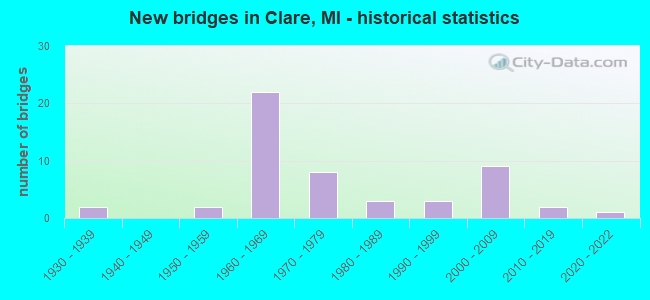
- New bridges - historical statistics
- 21930-1939
- 21950-1959
- 221960-1969
- 81970-1979
- 31980-1989
- 31990-1999
- 92000-2009
- 22010-2019
- 12020-2022

- Reconstructed bridges - Historical Statistics
- 21980-1989
- 11990-1999
- 02000-2009
- 12010-2019


- Bridge Condition - Deck
- 3.6%Very good
- 39.3%Good
- 46.4%Satisfactory
- 10.7%Fair

- Bridge Condition - Superstructure
- 7.1%Very good
- 25.0%Good
- 53.6%Satisfactory
- 14.3%Fair

- Bridge Condition - Substructure
- 21.4%Very good
- 39.3%Good
- 32.1%Satisfactory
- 3.6%Fair
- 3.6%Poor

- Bridge Condition - Channel
- 5.9%Excellent
- 11.8%Very good
- 47.1%Good
- 35.3%Satisfactory

- Bridge Condition - Culverts
- 16.7%Excellent
- 16.7%Very good
- 33.3%Good
- 16.7%Satisfactory
- 16.7%Serious
Find on map >> Show street view
Structure Number: 4251, Location: @ US-10 (Lat: 43.813811, Lng: -84.752806), Route carried "under" structure: US 10, Year Built: 2006, Structure Length: 0. m, Average Daily Traffic: 3,147 (year 2007), Truck Traffic: 2%, Features Intersected: US-10 BR, Facility Carried by Structure: US-127 NB
Minimum Vertical Clearance: 5.72m (18.77ft), Kilometerpoint: 0.220, Lanes on structure: 2, Lanes under structure: 2, Material/Design: Prestressed concrete, Design/Construction: Stringer/Multi-beam, Length of Maximum Span: 35.3m (115.8ft)
Find on map >> Show street view
Structure Number: 4252, Location: @ US-10 (Lat: 43.813914, Lng: -84.753150), Route carried "under" structure: US 10, Year Built: 2006, Structure Length: 0. m, Average Daily Traffic: 3,147 (year 2007), Truck Traffic: 2%, Features Intersected: US-10 BR, Facility Carried by Structure: US-127 SB
Minimum Vertical Clearance: 5.66m (18.57ft), Kilometerpoint: 0.190, Lanes on structure: 2, Lanes under structure: 2, Material/Design: Prestressed concrete, Design/Construction: Stringer/Multi-beam, Length of Maximum Span: 35.3m (115.8ft)
Find on map >> Show street view
Structure Number: 4259, Location: 4.1 MI S OF US-10 (Lat: 43.756853, Lng: -84.759597), Route carried "under" structure: US 127, Year Built: 1965, Structure Length: 0. m, Average Daily Traffic: 8,152 (year 2007), Truck Traffic: 10%, Features Intersected: US-127 SB, Facility Carried by Structure: COLEMAN RD
Minimum Vertical Clearance: 4.52m (14.83ft), Kilometerpoint: 35.994, Lanes on structure: 2, Lanes under structure: 2, Material/Design: Prestressed concrete, Design/Construction: Stringer/Multi-beam, Length of Maximum Span: 18.6m (61.0ft)
Find on map >> Show street view
Structure Number: 426, Location: 2.1 MI S OF US-10 (Lat: 43.785781, Lng: -84.758350), Route carried "under" structure: US 127, Year Built: 1964, Structure Length: 0. m, Average Daily Traffic: 16,304 (year 2007), Truck Traffic: 10%, Features Intersected: US-127, Facility Carried by Structure: GRASS LAKE RD
Minimum Vertical Clearance: 4.44m (14.57ft), Kilometerpoint: 39.091, Lanes on structure: 2, Lanes under structure: 4, Material/Design: Prestressed concrete, Design/Construction: Stringer/Multi-beam, Length of Maximum Span: 21.9m (71.9ft)
Find on map >> Show street view
Structure Number: 4261, Location: @ US-127 BR N CLARE EXIT (Lat: 43.801386, Lng: -84.758739), Route carried "under" structure: US 127, Year Built: 1961, Structure Length: 0. m, Average Daily Traffic: 6,302 (year 2007), Truck Traffic: 13%, Features Intersected: US-127 SB
Minimum Vertical Clearance: 4.52m (14.83ft), Kilometerpoint: 40.967, Lanes on structure: 2, Lanes under structure: 2, Material/Design: Steel, Design/Construction: Stringer/Multi-beam, Length of Maximum Span: 31.1m (102.0ft)
Find on map >> Show street view
Structure Number: 4262, Location: 4.1 MI S OF US-10 (Lat: 43.756864, Lng: -84.757472), Route carried "under" structure: US 127, Year Built: 1965, Structure Length: 0. m, Average Daily Traffic: 8,152 (year 2007), Truck Traffic: 10%, Features Intersected: US-127 NB, Facility Carried by Structure: COLEMAN RD
Minimum Vertical Clearance: 4.44m (14.57ft), Kilometerpoint: 35.875, Lanes on structure: 2, Lanes under structure: 2, Material/Design: Prestressed concrete, Design/Construction: Stringer/Multi-beam, Length of Maximum Span: 17.9m (58.7ft)
Find on map >> Show street view
Structure Number: 4272, Location: 1.4 MI SE OF CLARE COL (Lat: 43.808542, Lng: -84.722175), Route carried "under" structure: Ramp US 10, Year Built: 1962, Structure Length: 0. m, Average Daily Traffic: 1,346 (year 2007), Truck Traffic: 4%, Features Intersected: US-10 WB RAMP
Minimum Vertical Clearance: 5.00m (16.40ft), Kilometerpoint: 0.478, Lanes on structure: 2, Lanes under structure: 1, Material/Design: Steel, Design/Construction: Stringer/Multi-beam, Length of Maximum Span: 16.1m (52.8ft)