Bridge Statistics for Chattanooga, Tennessee (TN)
Condition, Traffic, Stress, Structural Evaluation, Project Costs
- National Bridge Inventory (NBI) Statistics
- 480Number of bridges
- 6,263ft / 1,909mTotal length
- $388,242,000Total costs
- 14,792,925Total average daily traffic
- 2,458,039Total average daily truck traffic
- National Bridge Inventory (NBI) Registered Bridges for Chattanooga
- No street view available for this location
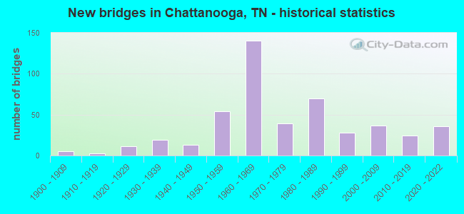
- New bridges - historical statistics
- 1Before 1900
- 51900-1909
- 31910-1919
- 111920-1929
- 191930-1939
- 131940-1949
- 541950-1959
- 1401960-1969
- 391970-1979
- 701980-1989
- 281990-1999
- 372000-2009
- 242010-2019
- 362020-2022

- Reconstructed bridges - Historical Statistics
- 31940-1949
- 01950-1959
- 01960-1969
- 71970-1979
- 161980-1989
- 311990-1999
- 12000-2009


- Bridge Condition - Deck
- 5.7%Very good
- 59.6%Good
- 25.7%Satisfactory
- 7.0%Fair
- 1.7%Poor
- 0.4%Serious

- Bridge Condition - Superstructure
- 11.7%Very good
- 34.8%Good
- 39.1%Satisfactory
- 10.9%Fair
- 2.6%Poor
- 0.9%Serious
- 0.4%Critical

- Bridge Condition - Substructure
- 3.9%Very good
- 58.3%Good
- 23.5%Satisfactory
- 10.0%Fair
- 4.3%Poor

- Bridge Condition - Channel
- 7.9%Very good
- 42.1%Good
- 38.6%Satisfactory
- 10.0%Fair
- 1.4%Poor

- Bridge Condition - Culverts
- 80.6%Good
- 15.3%Satisfactory
- 2.8%Fair
- 1.4%Serious
Find on map >> Show street view
Structure Number: 33I01240016, Location: IN CHATTANOOGA (Lat: 35.049433, Lng: -85.314150), Route carried "under" structure: City street 3550, Year Built: 2020, Structure Length: 0. m, Average Daily Traffic: 4,260 (year 2020), Truck Traffic: 4%, Features Intersected: I124, Facility Carried by Structure: I124
Minimum Vertical Clearance: 5.56m (18.24ft), Kilometerpoint: 0.410, Lanes on structure: 4, Lanes under structure: 2, Material/Design: Prestressed concrete, Design/Construction: Stringer/Multi-beam, Length of Maximum Span: 29.8m (97.8ft)
Find on map >> Show street view
Structure Number: 33I01240017, Location: DOWNTOWN CHATTANOOGA (Lat: 35.052000, Lng: -85.314250), Route carried "under" structure: Ramp State highway 389, Year Built: 2020, Structure Length: 0. m, Average Daily Traffic: 20,311 (year 2020), Truck Traffic: 9%, Features Intersected: I124 RL, Facility Carried by Structure: I124 RL
Minimum Vertical Clearance: 4.95m (16.24ft), Kilometerpoint: 0.016, Lanes on structure: 2, Lanes under structure: 1, Material/Design: Prestressed concrete, Design/Construction: Stringer/Multi-beam, Length of Maximum Span: 35.2m (115.5ft)
Find on map >> Show street view
Structure Number: 33I01240018, Location: DOWNTOWN CHATTANOOGA (Lat: 35.051983, Lng: -85.314433), Route carried "under" structure: State highway 389, Year Built: 2020, Structure Length: 0. m, Average Daily Traffic: 20,311 (year 2020), Truck Traffic: 9%, Features Intersected: I124 LL, Facility Carried by Structure: I124 LL
Minimum Vertical Clearance: 5.33m (17.49ft), Kilometerpoint: 0.000, Lanes on structure: 2, Lanes under structure: 1, Material/Design: Prestressed concrete, Design/Construction: Stringer/Multi-beam, Length of Maximum Span: 36.0m (118.1ft)
Find on map >> Show street view
Structure Number: 33I01240019, Location: .1 M E OF I124 INTERSECTI (Lat: 35.031417, Lng: -85.316950), Route carried "under" structure: City street 660, Year Built: 1961, Structure Length: 0. m, Average Daily Traffic: 1,630 (year 2022), Truck Traffic: 2%, Features Intersected: I124SB RP TO I24EB/A660, Facility Carried by Structure: I124 SB RP TO I24E
Minimum Vertical Clearance: 7.04m (23.10ft), Kilometerpoint: 0.547, Lanes on structure: 3, Lanes under structure: 2, Material/Design: Steel, Design/Construction: Stringer/Multi-beam, Length of Maximum Span: 21.9m (71.9ft)
Find on map >> Show street view
Structure Number: 33I01240023, Location: DOWNTOWN CHATTANOOGA (Lat: 35.052133, Lng: -85.313583), Route carried "under" structure: Ramp State highway 389, Year Built: 2020, Structure Length: 0. m, Average Daily Traffic: 20,311 (year 2020), Truck Traffic: 9%, Features Intersected: RAMP TO NB I124, Facility Carried by Structure: I124
Minimum Vertical Clearance: 4.88m (16.01ft), Kilometerpoint: 0.019, Lanes on structure: 10, Lanes under structure: 2, Material/Design: Prestressed concrete, Design/Construction: Stringer/Multi-beam, Length of Maximum Span: 30.0m (98.4ft)
Find on map >> Show street view
Structure Number: 33I01240025, Location: IN CHATTANOOGA (Lat: 35.049433, Lng: -85.313900), Route carried "under" structure: City street 3550, Year Built: 2020, Structure Length: 0. m, Average Daily Traffic: 3,027 (year 2020), Truck Traffic: 4%, Features Intersected: I124, Facility Carried by Structure: I124
Minimum Vertical Clearance: 5.03m (16.50ft), Kilometerpoint: 0.435, Lanes on structure: 3, Lanes under structure: 2, Material/Design: Prestressed concrete, Design/Construction: Stringer/Multi-beam, Length of Maximum Span: 29.8m (97.8ft)
Find on map >> Show street view
Structure Number: 33K35440001, Location: RIVERSIDE DRIVE AREA (Lat: 35.056250, Lng: -85.307667), Route carried "under" structure: City street 5395, Year Built: 1891, Structure Length: 0. m, Average Daily Traffic: 10,687 (year 2020), Truck Traffic: 4%, Features Intersected: RIVERFRONT PKWY., Facility Carried by Structure: PEDESTRIAN BRIDGE
Minimum Vertical Clearance: 6.91m (22.67ft), Kilometerpoint: 3.975, Lanes under structure: 2, Material/Design: Steel, Design/Construction: Truss - Thru, Length of Maximum Span: 42.1m (138.1ft)
Find on map >> Show street view
Structure Number: 33SR0020003, Location: NEAR CHATTANOOGA TENN. (Lat: 35.020867, Lng: -85.363217), Route carried "under" structure: US 11, Year Built: 1920, Structure Length: 0. m, Average Daily Traffic: 8,895 (year 2020), Truck Traffic: 2%, Features Intersected: SOUTHERN RAILWAY, Facility Carried by Structure: SOU RWY 350054V
Minimum Vertical Clearance: 3.76m (12.34ft), Kilometerpoint: 5.359, Lanes under structure: 2, Material/Design: Concrete, Design/Construction: Arch - Deck, Length of Maximum Span: 9.8m (32.2ft)
Find on map >> Show street view
Structure Number: 33SR0020011, Location: 0.18 MI. W OF SR-17 JCT. (Lat: 35.013750, Lng: -85.327950), Route carried "under" structure: US 11, Year Built: 1920, Structure Length: 0. m, Average Daily Traffic: 4,847 (year 2020), Truck Traffic: 4%, Features Intersected: SOUTHERN RAILWAY, Facility Carried by Structure: SOU RWY 736858E
Minimum Vertical Clearance: 4.12m (13.52ft), Kilometerpoint: 9.254, Lanes under structure: 4, Material/Design: Steel, Design/Construction: Stringer/Multi-beam, Length of Maximum Span: 14.6m (47.9ft)
Find on map >> Show street view
Structure Number: 33SR0020015, Location: 0.56 MI. E OF SR-27 JCT. (Lat: 35.042733, Lng: -85.300333), Route carried "under" structure: City street 5404, Year Built: 1941, Structure Length: 0. m, Average Daily Traffic: 5,699 (year 2020), Truck Traffic: 4%, Features Intersected: NORFOLK SOUTHERN RR, Facility Carried by Structure: SOU RWY 736894A
Minimum Vertical Clearance: 4.17m (13.68ft), Kilometerpoint: 0.901, Lanes under structure: 4, Material/Design: Steel, Design/Construction: Stringer/Multi-beam, Length of Maximum Span: 16.5m (54.1ft)
Find on map >> Show street view
Structure Number: 33SR0020019, Location: DOWNTOWN CHATTANOOGA (Lat: 35.031600, Lng: -85.264183), Route carried "under" structure: US 11, Year Built: 1956, Structure Length: 0. m, Average Daily Traffic: 22,096 (year 2020), Truck Traffic: 9%, Features Intersected: FAU 5404, Facility Carried by Structure: FAU 2
Minimum Vertical Clearance: 5.16m (16.93ft), Kilometerpoint: 18.250, Lanes on structure: 2, Lanes under structure: 4, Material/Design: Steel, Design/Construction: Girder and Floorbeam System, Length of Maximum Span: 26.2m (86.0ft)
Find on map >> Show street view
Structure Number: 33SR002002, Location: DOWNTOWN CHATTANOOGA (Lat: 35.031783, Lng: -85.264133), Route carried "under" structure: State highway 2, Year Built: 1956, Structure Length: 0. m, Average Daily Traffic: 22,096 (year 2020), Truck Traffic: 9%, Features Intersected: FAU 5404
Minimum Vertical Clearance: 5.23m (17.16ft), Kilometerpoint: 18.250, Lanes on structure: 2, Lanes under structure: 4, Material/Design: Steel, Design/Construction: Girder and Floorbeam System, Length of Maximum Span: 26.2m (86.0ft)
Find on map >> Show street view
Structure Number: 33SR0020027, Location: SR-2 / SR-153 JCT. (Lat: 35.032200, Lng: -85.182267), Route carried "under" structure: State highway 153, Year Built: 1961, Structure Length: 0. m, Average Daily Traffic: 64,309 (year 2020), Truck Traffic: 13%, Features Intersected: SR 2, Facility Carried by Structure: FAU 2
Minimum Vertical Clearance: 5.87m (19.26ft), Kilometerpoint: 1.497, Lanes on structure: 6, Lanes under structure: 4, Material/Design: Concrete continuous, Design/Construction: Tee Beam, Length of Maximum Span: 15.8m (51.8ft)
Find on map >> Show street view
Structure Number: 33SR0020035, Location: 0.89 MI. N OF I-24 JCT. (Lat: 35.042317, Lng: -85.309833), Route carried "under" structure: State highway 8, Year Built: 1984, Structure Length: 0. m, Average Daily Traffic: 5,472 (year 2020), Truck Traffic: 9%, Features Intersected: TVA BUILDING, Facility Carried by Structure: FAU 2
Minimum Vertical Clearance: 5.79m (19.00ft), Kilometerpoint: 14.017, Lanes under structure: 4, Material/Design: Steel, Design/Construction: Stringer/Multi-beam, Length of Maximum Span: 14.6m (47.9ft)
Find on map >> Show street view
Structure Number: 33SR0020037, Location: 0.82 MI. N OF I-24 JCT. (Lat: 35.042033, Lng: -85.309683), Route carried "under" structure: State highway 8, Year Built: 1984, Structure Length: 0. m, Average Daily Traffic: 5,472 (year 2020), Truck Traffic: 9%, Features Intersected: TVA BUILDING, Facility Carried by Structure: FAU 2
Minimum Vertical Clearance: 5.84m (19.16ft), Kilometerpoint: 13.921, Lanes under structure: 4, Material/Design: Steel, Design/Construction: Stringer/Multi-beam, Length of Maximum Span: 10.4m (34.1ft)
Find on map >> Show street view
Structure Number: 33SR0022001, Location: VOLUNTEER ORDINANCE WORKS (Lat: 35.072500, Lng: -85.160183), Route carried "under" structure: State highway 317, Year Built: 1943, Structure Length: 0. m, Average Daily Traffic: 14,402 (year 2020), Truck Traffic: 9%, Features Intersected: SOUTHERN RAILWAY, Facility Carried by Structure: SOU RWY 736672R
Minimum Vertical Clearance: 4.50m (14.76ft), Kilometerpoint: 4.957, Lanes under structure: 2, Material/Design: Steel, Design/Construction: Stringer/Multi-beam, Length of Maximum Span: 8.8m (28.9ft)
Find on map >> Show street view
Structure Number: 33SR0022005, Location: 0.82 MI. W OF I-75 JCT. (Lat: 35.066950, Lng: -85.146100), Route carried "under" structure: US 317, Year Built: 1963, Structure Length: 0. m, Average Daily Traffic: 14,402 (year 2020), Truck Traffic: 9%, Features Intersected: SOUTHERN RAILWAY, Facility Carried by Structure: SOU RWY 736680H
Minimum Vertical Clearance: 4.39m (14.40ft), Kilometerpoint: 6.389, Lanes under structure: 2, Material/Design: Steel, Design/Construction: Stringer/Multi-beam, Length of Maximum Span: 17.4m (57.1ft)
Find on map >> Show street view
Structure Number: 33SR0022009, Location: VOLUNTEER ORDINANCE WORKS (Lat: 35.070267, Lng: -85.152383), Route carried "under" structure: State highway 317, Year Built: 1943, Structure Length: 0. m, Average Daily Traffic: 14,402 (year 2020), Truck Traffic: 9%, Features Intersected: SOUTHERN RAILWAY, Facility Carried by Structure: USA RR 736673X
Minimum Vertical Clearance: 4.50m (14.76ft), Kilometerpoint: 5.665, Lanes under structure: 2, Material/Design: Steel, Design/Construction: Stringer/Multi-beam, Length of Maximum Span: 17.4m (57.1ft)
Find on map >> Show street view
Structure Number: 33SR0022019, Location: SR-153 / SR-317 JCT. (Lat: 35.074833, Lng: -85.198717), Route carried "under" structure: State highway 317, Year Built: 1961, Structure Length: 0. m, Average Daily Traffic: 17,801 (year 2020), Truck Traffic: 9%, Features Intersected: SR 153, Facility Carried by Structure: FAP 153
Minimum Vertical Clearance: 4.17m (13.68ft), Kilometerpoint: 1.271, Lanes on structure: 8, Lanes under structure: 5, Material/Design: Concrete continuous, Design/Construction: Tee Beam, Length of Maximum Span: 24.1m (79.1ft)
Find on map >> Show street view
Structure Number: 33SR0080007, Location: IN CHATTANOOGA (Lat: 35.056550, Lng: -85.309600), Route carried "under" structure: City street 5395, Year Built: 1917, Structure Length: 0. m, Average Daily Traffic: 10,687 (year 2020), Truck Traffic: 4%, Features Intersected: SR 8, Facility Carried by Structure: FAU 8
Minimum Vertical Clearance: 6.58m (21.59ft), Kilometerpoint: 3.766, Lanes on structure: 4, Lanes under structure: 2, Material/Design: Steel, Design/Construction: Movable - Bascule, Length of Maximum Span: 109.4m (358.9ft)
Find on map >> Show street view
Structure Number: 33SR0080013, Location: NEAR RED BANK (Lat: 35.075717, Lng: -85.322083), Route carried "under" structure: City street 29, Year Built: 1925, Structure Length: 0. m, Average Daily Traffic: 1,220 (year 2022), Truck Traffic: 2%, Features Intersected: SR 8, Facility Carried by Structure: FAU 8 RP
Minimum Vertical Clearance: 9.80m (32.15ft), Kilometerpoint: 0.193, Lanes on structure: 2, Lanes under structure: 2, Material/Design: Steel continuous, Design/Construction: Stringer/Multi-beam, Length of Maximum Span: 100.3m (329.1ft)
Find on map >> Show street view
Structure Number: 33SR0080023, Location: 0.6 MI. E OF SR-27 JCT. (Lat: 35.032567, Lng: -85.297567), Route carried "under" structure: US 41, Year Built: 1970, Structure Length: 0. m, Average Daily Traffic: 7,081 (year 2020), Truck Traffic: 4%, Features Intersected: SOUTHERN RAILWAY, Facility Carried by Structure: SOU RWY 350050T
Minimum Vertical Clearance: 4.48m (14.70ft), Kilometerpoint: 12.038, Lanes under structure: 4, Material/Design: Prestressed concrete, Design/Construction: Box Beam or Girders - Multiple, Length of Maximum Span: 13.1m (43.0ft)
Find on map >> Show street view
Structure Number: 33SR0170003, Location: 0.26 MI. N OF SR-58 JCT. (Lat: 35.012400, Lng: -85.326350), Route carried "under" structure: State highway 17, Year Built: 1907, Structure Length: 0. m, Average Daily Traffic: 12,384 (year 2020), Truck Traffic: 9%, Features Intersected: SOUTHERN RAILWAY, Facility Carried by Structure: SOU RWY 736856R
Minimum Vertical Clearance: 4.22m (13.85ft), Kilometerpoint: 3.299, Lanes under structure: 2, Material/Design: Concrete, Design/Construction: Arch - Deck, Length of Maximum Span: 9.1m (29.9ft)
Find on map >> Show street view
Structure Number: 33SR0170013, Location: 0.57 MI. W OF SR-153 JCT. (Lat: 35.080400, Lng: -85.216200), Route carried "under" structure: State highway 17, Year Built: 1965, Structure Length: 0. m, Average Daily Traffic: 14,275 (year 2020), Truck Traffic: 9%, Features Intersected: SOUTHERN RAILWAY, Facility Carried by Structure: SOU RWY
Minimum Vertical Clearance: 10.39m (34.09ft), Kilometerpoint: 13.454, Lanes under structure: 2, Material/Design: Steel, Design/Construction: Stringer/Multi-beam, Length of Maximum Span: 31.7m (104.0ft)
Find on map >> Show street view
Structure Number: 33SR0270005, Location: 3 MI. FR. MARION CO. LINE (Lat: 35.100133, Lng: -85.349117), Route carried "under" structure: State highway 27, Year Built: 1984, Structure Length: 0. m, Average Daily Traffic: 4,501 (year 2020), Truck Traffic: 4%, Features Intersected: INDUSTRIAL CONVEYOR BELT
Minimum Vertical Clearance: 5.23m (17.16ft), Kilometerpoint: 4.828, Lanes under structure: 2, Material/Design: Steel, Length of Maximum Span: 8.2m (26.9ft)
Find on map >> Show street view
Structure Number: 33SR0270009, Location: 3 MI. FR. MARION CO. LINE (Lat: 35.100433, Lng: -85.344350), Route carried "under" structure: State highway 27, Year Built: 2003, Structure Length: 0. m, Average Daily Traffic: 4,501 (year 2020), Truck Traffic: 4%, Features Intersected: INDUSTRIAL CONVEYOR BELT
Minimum Vertical Clearance: 6.38m (20.93ft), Kilometerpoint: 5.214, Lanes under structure: 2, Material/Design: Steel, Length of Maximum Span: 25.0m (82.0ft)
Find on map >> Show street view
Structure Number: 33SR0290007, Location: 0.63 MI. S OF SR-29 JCT. (Lat: 35.179033, Lng: -85.247600), Route carried "under" structure: Ramp US 27, Year Built: 1959, Structure Length: 0. m, Average Daily Traffic: 4,049 (year 2020), Truck Traffic: 4%, Features Intersected: SR 153 SBL, Facility Carried by Structure: FAP 153 SBL
Minimum Vertical Clearance: 4.67m (15.32ft), Kilometerpoint: 12.440, Lanes on structure: 2, Lanes under structure: 1, Material/Design: Concrete continuous, Design/Construction: Tee Beam, Length of Maximum Span: 20.7m (67.9ft)
Find on map >> Show street view
Structure Number: 33SR0290043, Location: SR-29 / SR-153 JCT. (Lat: 35.187950, Lng: -85.246083), Route carried "under" structure: County highway 153, Year Built: 1977, Structure Length: 0. m, Average Daily Traffic: 30,459 (year 2020), Truck Traffic: 9%, Features Intersected: SR 29 RT LN, Facility Carried by Structure: FAP 29
Minimum Vertical Clearance: 5.56m (18.24ft), Kilometerpoint: 20.680, Lanes on structure: 2, Lanes under structure: 4, Material/Design: Prestressed concrete continuous, Design/Construction: Box Beam or Girders - Single/Spread, Length of Maximum Span: 25.9m (85.0ft)
Find on map >> Show street view
Structure Number: 33SR0290044, Location: SR-29 / SR-153 JCT. (Lat: 35.188250, Lng: -85.246117), Route carried "under" structure: City street 2162, Year Built: 1977, Structure Length: 0. m, Average Daily Traffic: 7,583 (year 2020), Truck Traffic: 4%, Features Intersected: SR 29 LT LN, Facility Carried by Structure: FAP 29 SBL
Minimum Vertical Clearance: 5.46m (17.91ft), Kilometerpoint: 0.016, Lanes on structure: 2, Lanes under structure: 4, Material/Design: Prestressed concrete continuous, Design/Construction: Box Beam or Girders - Single/Spread, Length of Maximum Span: 25.9m (85.0ft)
Find on map >> Show street view
Structure Number: 33SR0290077, Location: 3.36 MI. N OF SR-8 JCT. (Lat: 35.125750, Lng: -85.294183), Route carried "under" structure: City street 150, Year Built: 1987, Structure Length: 0. m, Average Daily Traffic: 310 (year 2022), Truck Traffic: 2%, Features Intersected: SR 29 / NFA A150, Facility Carried by Structure: FAP 29
Minimum Vertical Clearance: 12.62m (41.40ft), Kilometerpoint: 0.340, Lanes on structure: 3, Lanes under structure: 2, Material/Design: Steel continuous, Design/Construction: Stringer/Multi-beam, Length of Maximum Span: 38.1m (125.0ft)
Find on map >> Show street view
Structure Number: 33SR0290078, Location: 3.36 MI. N OF SR-8 JCT. (Lat: 35.126250, Lng: -85.294450), Route carried "under" structure: City street 150, Year Built: 1987, Structure Length: 0. m, Average Daily Traffic: 310 (year 2022), Truck Traffic: 2%, Features Intersected: SR 29 / NFA A150, Facility Carried by Structure: FAP 29
Minimum Vertical Clearance: 11.51m (37.76ft), Kilometerpoint: 0.380, Lanes on structure: 2, Lanes under structure: 2, Material/Design: Steel continuous, Design/Construction: Stringer/Multi-beam, Length of Maximum Span: 38.1m (125.0ft)
Find on map >> Show street view
Structure Number: 33SR0290079, Location: 3.24 MI. S OF SR-153 JCT. (Lat: 35.157567, Lng: -85.285400), Route carried "under" structure: City street 4034, Year Built: 1987, Structure Length: 0. m, Average Daily Traffic: 961 (year 2020), Truck Traffic: 3%, Features Intersected: SR 29 / FAU 4034, Facility Carried by Structure: FAP 29
Minimum Vertical Clearance: 5.92m (19.42ft), Kilometerpoint: 0.016, Lanes on structure: 2, Lanes under structure: 2, Material/Design: Prestressed concrete continuous, Design/Construction: Box Beam or Girders - Single/Spread, Length of Maximum Span: 21.3m (69.9ft)
Find on map >> Show street view
Structure Number: 33SR029008, Location: 3.24 MI. S OF SR-153 JCT. (Lat: 35.157733, Lng: -85.285583), Route carried "under" structure: City street 3594, Year Built: 1987, Structure Length: 0. m, Average Daily Traffic: 14,260 (year 2020), Truck Traffic: 3%, Features Intersected: SR 29 / FAU 3594, Facility Carried by Structure: FAP 29
Minimum Vertical Clearance: 5.19m (17.03ft), Kilometerpoint: 7.146, Lanes on structure: 2, Lanes under structure: 2, Material/Design: Prestressed concrete continuous, Design/Construction: Box Beam or Girders - Single/Spread, Length of Maximum Span: 21.3m (69.9ft)
Find on map >> Show street view
Structure Number: 33SR0290081, Location: 2.57 MI. S OF SR-153 JCT. (Lat: 35.166733, Lng: -85.282367), Route carried "under" structure: City street 592, Year Built: 1987, Structure Length: 0. m, Average Daily Traffic: 110 (year 2022), Truck Traffic: 2%, Features Intersected: SR 29 / NFA C592, Facility Carried by Structure: FAP 29
Minimum Vertical Clearance: 4.53m (14.86ft), Kilometerpoint: 0.692, Lanes on structure: 2, Lanes under structure: 2, Material/Design: Prestressed concrete continuous, Design/Construction: Box Beam or Girders - Single/Spread, Length of Maximum Span: 21.3m (69.9ft)
Find on map >> Show street view
Structure Number: 33SR0290082, Location: 2.57 MI. S OF SR-153 JCT. (Lat: 35.166817, Lng: -85.282633), Route carried "under" structure: City street 592, Year Built: 1987, Structure Length: 0. m, Average Daily Traffic: 110 (year 2022), Truck Traffic: 2%, Features Intersected: SR 29 / NFA C592, Facility Carried by Structure: FAP 29
Minimum Vertical Clearance: 5.44m (17.85ft), Kilometerpoint: 0.723, Lanes on structure: 2, Lanes under structure: 2, Material/Design: Prestressed concrete continuous, Design/Construction: Box Beam or Girders - Single/Spread, Length of Maximum Span: 21.3m (69.9ft)
Find on map >> Show street view
Structure Number: 33SR0290083, Location: 2.2 MI. S OF SR-153 JCT. (Lat: 35.171550, Lng: -85.278900), Route carried "under" structure: City street 593, Year Built: 1987, Structure Length: 0. m, Average Daily Traffic: 90 (year 2022), Truck Traffic: 2%, Features Intersected: SR 29 / NFA C593, Facility Carried by Structure: FAP 29
Minimum Vertical Clearance: 4.93m (16.17ft), Kilometerpoint: 0.723, Lanes on structure: 2, Lanes under structure: 2, Material/Design: Prestressed concrete continuous, Design/Construction: Box Beam or Girders - Single/Spread, Length of Maximum Span: 21.3m (69.9ft)
Find on map >> Show street view
Structure Number: 33SR0290084, Location: 2.2 MI. S OF SR-153 JCT. (Lat: 35.171683, Lng: -85.279133), Route carried "under" structure: City street 593, Year Built: 1987, Structure Length: 0. m, Average Daily Traffic: 90 (year 2022), Truck Traffic: 2%, Features Intersected: SR 29 / NFA C593, Facility Carried by Structure: FAP 29
Minimum Vertical Clearance: 4.96m (16.27ft), Kilometerpoint: 0.756, Lanes on structure: 2, Lanes under structure: 2, Material/Design: Prestressed concrete continuous, Design/Construction: Box Beam or Girders - Single/Spread, Length of Maximum Span: 21.3m (69.9ft)
Find on map >> Show street view
Structure Number: 33SR0290085, Location: 1.71 MI. S OF SR-153 JCT. (Lat: 35.177167, Lng: -85.273350), Route carried "under" structure: City street 177, Year Built: 1987, Structure Length: 0. m, Average Daily Traffic: 50 (year 2022), Truck Traffic: 2%, Features Intersected: SR 29 / NFA C177, Facility Carried by Structure: FAP 29
Minimum Vertical Clearance: 7.80m (25.59ft), Kilometerpoint: 0.212, Lanes on structure: 2, Lanes under structure: 2, Material/Design: Prestressed concrete continuous, Design/Construction: Box Beam or Girders - Single/Spread, Length of Maximum Span: 22.3m (73.2ft)
Find on map >> Show street view
Structure Number: 33SR0290086, Location: 1.71 MI. S OF SR-153 JCT. (Lat: 35.177367, Lng: -85.273567), Route carried "under" structure: City street 177, Year Built: 1987, Structure Length: 0. m, Average Daily Traffic: 50 (year 2022), Truck Traffic: 2%, Features Intersected: SR 29 / NFA C177, Facility Carried by Structure: FAP 29
Minimum Vertical Clearance: 6.91m (22.67ft), Kilometerpoint: 0.241, Lanes on structure: 2, Lanes under structure: 2, Material/Design: Prestressed concrete continuous, Design/Construction: Box Beam or Girders - Single/Spread, Length of Maximum Span: 22.3m (73.2ft)
Find on map >> Show street view
Structure Number: 33SR0290087, Location: 1.39 MI. S OF SR-153 JCT. (Lat: 35.179417, Lng: -85.268567), Route carried "under" structure: City street 176, Year Built: 1988, Structure Length: 0. m, Average Daily Traffic: 180 (year 2022), Truck Traffic: 2%, Features Intersected: SR 29 / NFA C176, Facility Carried by Structure: FAP 29
Minimum Vertical Clearance: 10.90m (35.76ft), Kilometerpoint: 1.146, Lanes on structure: 2, Lanes under structure: 2, Material/Design: Prestressed concrete continuous, Design/Construction: Box Beam or Girders - Single/Spread, Length of Maximum Span: 25.0m (82.0ft)
Find on map >> Show street view
Structure Number: 33SR0290088, Location: 1.39 MI. S OF SR-153 JCT. (Lat: 35.179600, Lng: -85.268717), Route carried "under" structure: City street 176, Year Built: 1988, Structure Length: 0. m, Average Daily Traffic: 180 (year 2022), Truck Traffic: 2%, Features Intersected: SR 29 / NFA C176, Facility Carried by Structure: FAP 29
Minimum Vertical Clearance: 11.73m (38.48ft), Kilometerpoint: 1.173, Lanes on structure: 2, Lanes under structure: 2, Material/Design: Prestressed concrete continuous, Design/Construction: Box Beam or Girders - Single/Spread, Length of Maximum Span: 25.0m (82.0ft)
Find on map >> Show street view
Structure Number: 33SR0290089, Location: 0.5 MI. S OF SR-153 JCT. (Lat: 35.184683, Lng: -85.254200), Route carried "under" structure: City street 891, Year Built: 1988, Structure Length: 0. m, Average Daily Traffic: 2,310 (year 2018), Truck Traffic: 2%, Features Intersected: SR 29 / NFA C891, Facility Carried by Structure: FAP 29
Minimum Vertical Clearance: 6.79m (22.28ft), Kilometerpoint: 2.795, Lanes on structure: 2, Lanes under structure: 2, Material/Design: Prestressed concrete continuous, Design/Construction: Box Beam or Girders - Single/Spread, Length of Maximum Span: 25.0m (82.0ft)
Find on map >> Show street view
Structure Number: 33SR029009, Location: 0.5 MI. S OF SR-153 JCT. (Lat: 35.185000, Lng: -85.254150), Route carried "under" structure: City street 891, Year Built: 1988, Structure Length: 0. m, Average Daily Traffic: 2,310 (year 2018), Truck Traffic: 2%, Features Intersected: SR 29 / NFA C891, Facility Carried by Structure: FAP 29
Minimum Vertical Clearance: 5.01m (16.44ft), Kilometerpoint: 2.829, Lanes on structure: 2, Lanes under structure: 2, Material/Design: Prestressed concrete continuous, Design/Construction: Box Beam or Girders - Single/Spread, Length of Maximum Span: 25.0m (82.0ft)
Find on map >> Show street view
Structure Number: 33SR0380001, Location: 1.95 MI. S OF SR-2 JCT. (Lat: 34.996617, Lng: -85.390300), Route carried "under" structure: US 11, Year Built: 1933, Structure Length: 0. m, Average Daily Traffic: 5,605 (year 2020), Truck Traffic: 4%, Features Intersected: CSX RAILROAD, Facility Carried by Structure: CSX RR 350021H
Minimum Vertical Clearance: 4.32m (14.17ft), Kilometerpoint: 1.690, Lanes under structure: 2, Material/Design: Steel, Design/Construction: Stringer/Multi-beam, Length of Maximum Span: 7.3m (24.0ft)
Find on map >> Show street view
Structure Number: 33SR0580001, Location: 1.12 MI. S OF I-24 JCT. (Lat: 35.013383, Lng: -85.315117), Route carried "under" structure: State highway 58, Year Built: 1947, Structure Length: 0. m, Average Daily Traffic: 8,876 (year 2020), Truck Traffic: 4%, Features Intersected: SOUTHERN RAILWAY, Facility Carried by Structure: SOU RWY 736854C
Minimum Vertical Clearance: 2.74m (8.99ft), Kilometerpoint: 5.214, Lanes under structure: 2, Material/Design: Concrete, Design/Construction: Slab, Length of Maximum Span: 43.9m (144.0ft)
Find on map >> Show street view
Structure Number: 33SR0580007, Location: 0.41 MI. E OF SR-8 JCT. (Lat: 35.053483, Lng: -85.304033), Route carried "under" structure: City street 3546, Year Built: 1972, Structure Length: 0. m, Average Daily Traffic: 13,400 (year 2020), Truck Traffic: 4%, Features Intersected: RIVERSIDE DR.
Minimum Vertical Clearance: 4.95m (16.24ft), Kilometerpoint: 1.529, Lanes on structure: 3, Lanes under structure: 2, Material/Design: Prestressed concrete continuous, Design/Construction: Box Beam or Girders - Single/Spread, Length of Maximum Span: 19.8m (65.0ft)
Find on map >> Show street view
Structure Number: 33SR0580009, Location: 0.7 MI. E OF SR-8 JCT. (Lat: 35.051367, Lng: -85.299550), Route carried "under" structure: City street 396, Year Built: 1971, Structure Length: 0. m, Average Daily Traffic: 8,520 (year 2022), Truck Traffic: 5%, Features Intersected: FAU 5395, Facility Carried by Structure: FAU 5395
Minimum Vertical Clearance: 4.98m (16.34ft), Kilometerpoint: 0.016, Lanes on structure: 4, Lanes under structure: 4, Material/Design: Prestressed concrete, Design/Construction: Box Beam or Girders - Single/Spread, Length of Maximum Span: 20.1m (65.9ft)
Find on map >> Show street view
Structure Number: 33SR0580015, Location: 0.82 MI. W OF SR-319 JCT. (Lat: 35.095783, Lng: -85.235383), Route carried "under" structure: State highway 319, Year Built: 1962, Structure Length: 0. m, Average Daily Traffic: 22,566 (year 2020), Truck Traffic: 9%, Features Intersected: SOUTHERN RAILROAD, Facility Carried by Structure: SOU RR 736682W
Minimum Vertical Clearance: 4.73m (15.52ft), Kilometerpoint: 1.867, Lanes under structure: 4, Material/Design: Steel, Design/Construction: Stringer/Multi-beam, Length of Maximum Span: 22.6m (74.1ft)
Find on map >> Show street view
Structure Number: 33SR0580017, Location: SR153 & SR58 JCT. (Lat: 35.082283, Lng: -85.206617), Route carried "under" structure: State highway 58, Year Built: 1954, Structure Length: 0. m, Average Daily Traffic: 32,250 (year 2020), Truck Traffic: 9%, Features Intersected: SR 153, Facility Carried by Structure: FAP 153
Minimum Vertical Clearance: 5.05m (16.57ft), Kilometerpoint: 7.371, Lanes on structure: 8, Lanes under structure: 4, Material/Design: Concrete, Design/Construction: Tee Beam, Length of Maximum Span: 15.5m (50.9ft)
Find on map >> Show street view
Structure Number: 33SR0580019, Location: SR-58 / SR-153 JCT. (Lat: 35.090267, Lng: -85.218367), Route carried "under" structure: State highway 153, Year Built: 1963, Structure Length: 0. m, Average Daily Traffic: 57,428 (year 2020), Truck Traffic: 13%, Features Intersected: SR-58 EB / SR-153, Facility Carried by Structure: FAP 58 RL
Minimum Vertical Clearance: 5.18m (16.99ft), Kilometerpoint: 8.948, Lanes on structure: 2, Lanes under structure: 6, Material/Design: Concrete continuous, Design/Construction: Tee Beam, Length of Maximum Span: 19.2m (63.0ft)
Find on map >> Show street view
Structure Number: 33SR058002, Location: SR-58 / SR-153 JCT. (Lat: 35.090350, Lng: -85.218533), Route carried "under" structure: State highway 153, Year Built: 1963, Structure Length: 0. m, Average Daily Traffic: 57,428 (year 2020), Truck Traffic: 13%, Features Intersected: SR-58 WB / SR-153, Facility Carried by Structure: FAP 58 LL
Minimum Vertical Clearance: 4.78m (15.68ft), Kilometerpoint: 8.964, Lanes on structure: 2, Lanes under structure: 6, Material/Design: Concrete continuous, Design/Construction: Tee Beam, Length of Maximum Span: 19.2m (63.0ft)
Find on map >> Show street view
Structure Number: 33SR0580045, Location: SR-319 / FAU 5395 JCT. (Lat: 35.094667, Lng: -85.249567), Route carried "under" structure: City street 5395, Year Built: 1981, Structure Length: 0. m, Average Daily Traffic: 28,633 (year 2020), Truck Traffic: 9%, Features Intersected: SR 319, Facility Carried by Structure: FAU 319
Minimum Vertical Clearance: 5.08m (16.67ft), Kilometerpoint: 12.215, Lanes on structure: 6, Lanes under structure: 5, Material/Design: Concrete, Design/Construction: Box Beam or Girders - Single/Spread, Length of Maximum Span: 48.8m (160.1ft)
Find on map >> Show street view
Structure Number: 33SR0580047, Location: DOWNTOWN CHATTANOOGA (Lat: 35.055483, Lng: -85.305550), Route carried "under" structure: City street 5395, Year Built: 1971, Structure Length: 0. m, Average Daily Traffic: 13,084 (year 2020), Truck Traffic: 9%, Features Intersected: HIGH STREET, Facility Carried by Structure: NFA A342
Minimum Vertical Clearance: 5.28m (17.32ft), Kilometerpoint: 4.297, Lanes on structure: 2, Lanes under structure: 2, Material/Design: Concrete continuous, Design/Construction: Box Beam or Girders - Single/Spread, Length of Maximum Span: 34.4m (112.9ft)
Find on map >> Show street view
Structure Number: 33SR0580047, Location: DOWNTOWN CHATTANOOGA (Lat: 35.054133, Lng: -85.305617), Route carried "under" structure: Ramp City street 3546, Year Built: 1971, Structure Length: 0. m, Average Daily Traffic: 13,400 (year 2020), Truck Traffic: 4%, Features Intersected: HIGH STREET
Minimum Vertical Clearance: 5.82m (19.09ft), Kilometerpoint: 1.448, Lanes on structure: 2, Lanes under structure: 2, Material/Design: Concrete continuous, Design/Construction: Box Beam or Girders - Single/Spread, Length of Maximum Span: 34.4m (112.9ft)
Find on map >> Show street view
Structure Number: 33SR0580051, Location: E. 3RD ST/ DOWNTOWN CHATT (Lat: 35.050983, Lng: -85.297167), Route carried "under" structure: Ramp City street 5395, Year Built: 1971, Structure Length: 0. m, Average Daily Traffic: 22,416 (year 2020), Truck Traffic: 9%, Features Intersected: E. 3RD ST., Facility Carried by Structure: FAU 3549
Minimum Vertical Clearance: 4.70m (15.42ft), Kilometerpoint: 5.182, Lanes on structure: 3, Lanes under structure: 1, Material/Design: Prestressed concrete continuous, Design/Construction: Box Beam or Girders - Multiple, Length of Maximum Span: 19.8m (65.0ft)
Find on map >> Show street view
Structure Number: 33SR1530003, Location: 0.44 MI. N OF I-75 JCT. (Lat: 35.028600, Lng: -85.175617), Route carried "under" structure: City street 3603, Year Built: 1959, Structure Length: 0. m, Average Daily Traffic: 11,248 (year 2020), Truck Traffic: 4%, Features Intersected: SR 153, Facility Carried by Structure: FAP 153
Minimum Vertical Clearance: 4.42m (14.50ft), Kilometerpoint: 1.416, Lanes on structure: 3, Lanes under structure: 2, Material/Design: Prestressed concrete continuous, Design/Construction: Box Beam or Girders - Multiple, Length of Maximum Span: 16.2m (53.1ft)
Find on map >> Show street view
Structure Number: 33SR1530004, Location: 0.44 MI. N OF I-75 JCT. (Lat: 35.027833, Lng: -85.176150), Route carried "under" structure: City street 3603, Year Built: 1959, Structure Length: 0. m, Average Daily Traffic: 11,248 (year 2020), Truck Traffic: 4%, Features Intersected: SR 153, Facility Carried by Structure: FAP 153
Minimum Vertical Clearance: 4.45m (14.60ft), Kilometerpoint: 1.304, Lanes on structure: 4, Lanes under structure: 2, Material/Design: Prestressed concrete continuous, Design/Construction: Box Beam or Girders - Multiple, Length of Maximum Span: 16.2m (53.1ft)
Find on map >> Show street view
Structure Number: 33SR1530007, Location: 0.74 MI. N OF SR-2 JCT. (Lat: 35.042317, Lng: -85.186467), Route carried "under" structure: State highway 153, Year Built: 1961, Structure Length: 0. m, Average Daily Traffic: 60,351 (year 2020), Truck Traffic: 13%, Features Intersected: FAU 3602 SHEPHERD RD, Facility Carried by Structure: FAU 3602
Minimum Vertical Clearance: 5.18m (16.99ft), Kilometerpoint: 2.688, Lanes on structure: 2, Lanes under structure: 4, Material/Design: Concrete continuous, Design/Construction: Tee Beam, Length of Maximum Span: 15.5m (50.9ft)
Find on map >> Show street view
Structure Number: 33SR1530013, Location: 2 MI. N OF SR-2 JCT. (Lat: 35.054133, Lng: -85.190683), Route carried "under" structure: State highway 153, Year Built: 1961, Structure Length: 0. m, Average Daily Traffic: 60,769 (year 2020), Truck Traffic: 13%, Features Intersected: FAU 3556, Facility Carried by Structure: FAU 3556
Minimum Vertical Clearance: 4.95m (16.24ft), Kilometerpoint: 4.039, Lanes on structure: 2, Lanes under structure: 6, Material/Design: Concrete continuous, Design/Construction: Tee Beam, Length of Maximum Span: 17.4m (57.1ft)
Find on map >> Show street view
Structure Number: 33SR1530014, Location: 2 MI. N OF SR-2 JCT. (Lat: 35.054233, Lng: -85.190750), Route carried "under" structure: State highway 153, Year Built: 1961, Structure Length: 0. m, Average Daily Traffic: 60,769 (year 2020), Truck Traffic: 13%, Features Intersected: FAU 3556, Facility Carried by Structure: FAU 3556
Minimum Vertical Clearance: 5.00m (16.40ft), Kilometerpoint: 4.056, Lanes on structure: 2, Lanes under structure: 6, Material/Design: Concrete continuous, Design/Construction: Tee Beam, Length of Maximum Span: 17.4m (57.1ft)
Find on map >> Show street view
Structure Number: 33SR1530015, Location: JERSEY PIKE / SR-153 (Lat: 35.065083, Lng: -85.195250), Route carried "under" structure: State highway 153, Year Built: 1963, Structure Length: 0. m, Average Daily Traffic: 60,729 (year 2020), Truck Traffic: 13%, Features Intersected: JERSEY PIKE (FAU 3601), Facility Carried by Structure: FAU 3601
Minimum Vertical Clearance: 4.98m (16.34ft), Kilometerpoint: 5.343, Lanes on structure: 2, Lanes under structure: 6, Material/Design: Concrete continuous, Design/Construction: Tee Beam, Length of Maximum Span: 15.5m (50.9ft)
Find on map >> Show street view
Structure Number: 33SR1530021, Location: CHICKAMAUGA DAM (Lat: 35.109033, Lng: -85.229250), Route carried "under" structure: City street 3542, Year Built: 1954, Structure Length: 0. m, Average Daily Traffic: 12,022 (year 2020), Truck Traffic: 4%, Features Intersected: UNDER TVA BRIDGE (SR153), Facility Carried by Structure: FAP 153
Minimum Vertical Clearance: 9.14m (29.99ft), Kilometerpoint: 2.889, Lanes on structure: 2, Lanes under structure: 2, Material/Design: Steel continuous, Design/Construction: Girder and Floorbeam System, Length of Maximum Span: 58.5m (191.9ft)
Find on map >> Show street view
Structure Number: 33SR1530029, Location: 2.4 MI.N. OF TN.RIVER (Lat: 35.131050, Lng: -85.244367), Route carried "under" structure: State highway 153, Year Built: 1954, Structure Length: 0. m, Average Daily Traffic: 38,730 (year 2020), Truck Traffic: 9%, Features Intersected: FAU 3588, Facility Carried by Structure: FAU 3588
Minimum Vertical Clearance: 5.61m (18.41ft), Kilometerpoint: 14.291, Lanes on structure: 2, Lanes under structure: 4, Material/Design: Concrete, Design/Construction: Tee Beam, Length of Maximum Span: 15.5m (50.9ft)
Find on map >> Show street view
Structure Number: 33SR153003, Location: 2.4 MI.N.OF TN. RV. (Lat: 35.131300, Lng: -85.244350), Route carried "under" structure: State highway 153, Year Built: 1954, Structure Length: 0. m, Average Daily Traffic: 38,730 (year 2020), Truck Traffic: 9%, Features Intersected: FAU 3588, Facility Carried by Structure: FAU 3588
Minimum Vertical Clearance: 5.21m (17.09ft), Kilometerpoint: 14.307, Lanes on structure: 2, Lanes under structure: 4, Material/Design: Concrete, Design/Construction: Tee Beam, Length of Maximum Span: 15.5m (50.9ft)
Find on map >> Show street view
Structure Number: 580A2550001, Location: 3.5 MI SE JCT SR2&SR134 (Lat: 34.989269, Lng: -85.499489), Route carried "under" structure: County highway 251, Year Built: 1910, Structure Length: 0. m, Average Daily Traffic: 260 (year 2022), Truck Traffic: 2%, Features Intersected: CSX RAILROAD, Facility Carried by Structure: NFA A255 350016L
Minimum Vertical Clearance: 2.82m (9.25ft), Kilometerpoint: 0.045, Lanes under structure: 1, Material/Design: Concrete, Design/Construction: Slab, Length of Maximum Span: 4.3m (14.1ft)
Find on map >> Show street view
Structure Number: 58I00240051, Location: NEAR SOUTH PITTSBURG TENN (Lat: 35.001167, Lng: -85.512000), Route carried "under" structure: Interstate 24, Year Built: 1964, Structure Length: 0. m, Average Daily Traffic: 49,066 (year 2020), Truck Traffic: 42%, Features Intersected: CSX RAILROAD
Minimum Vertical Clearance: 22.45m (73.65ft), Kilometerpoint: 46.462, Lanes under structure: 4, Material/Design: Steel, Design/Construction: Stringer/Multi-beam, Length of Maximum Span: 30.5m (100.1ft)
Find on map >> Show street view
Structure Number: 58I00240051, Location: NEAR WHITESIDE TENN. (Lat: 35.000667, Lng: -85.511700), Route carried "under" structure: State highway 134, Year Built: 1968, Structure Length: 0. m, Average Daily Traffic: 1,015 (year 2020), Truck Traffic: 4%, Features Intersected: CSX RAILROAD
Minimum Vertical Clearance: 22.00m (72.18ft), Kilometerpoint: 4.410, Lanes under structure: 2, Material/Design: Steel continuous, Design/Construction: Stringer/Multi-beam, Length of Maximum Span: 30.5m (100.1ft)
Find on map >> Show street view
Structure Number: 58I00240055, Location: NEAR SOUTH PITTSBURG TENN (Lat: 34.991017, Lng: -85.508383), Route carried "under" structure: Interstate 24, Year Built: 1965, Structure Length: 0. m, Average Daily Traffic: 49,066 (year 2020), Truck Traffic: 42%, Features Intersected: SCRATCH ANKLE RD / I-24, Facility Carried by Structure: NFA A360
Minimum Vertical Clearance: 4.93m (16.17ft), Kilometerpoint: 47.653, Lanes on structure: 2, Lanes under structure: 4, Material/Design: Steel continuous, Design/Construction: Stringer/Multi-beam, Length of Maximum Span: 32.0m (105.0ft)
Find on map >> Show street view
Structure Number: 58I00240059, Location: 1 MI.FROM GA.TN.ST.LINE (Lat: 34.987933, Lng: -85.501667), Route carried "under" structure: Interstate 24, Year Built: 2015, Structure Length: 0. m, Average Daily Traffic: 49,066 (year 2020), Truck Traffic: 42%, Features Intersected: MURPHY HOLLOW RD / I-24, Facility Carried by Structure: NFA A261
Minimum Vertical Clearance: 5.05m (16.57ft), Kilometerpoint: 48.795, Lanes on structure: 2, Lanes under structure: 4, Material/Design: Prestressed concrete, Design/Construction: Stringer/Multi-beam, Length of Maximum Span: 35.2m (115.5ft)