Bridge Statistics for Carbon Hill, Alabama (AL)
Condition, Traffic, Stress, Structural Evaluation, Project Costs
- National Bridge Inventory (NBI) Statistics
- 54Number of bridges
- 1,237ft / 377mTotal length
- $132,058,000Total costs
- 235,100Total average daily traffic
- 43,777Total average daily truck traffic
- National Bridge Inventory (NBI) Registered Bridges for Carbon Hill
- No street view available for this location
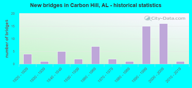
- New bridges - historical statistics
- 41920-1929
- 11930-1939
- 51940-1949
- 21950-1959
- 71960-1969
- 21970-1979
- 11980-1989
- 151990-1999
- 162000-2009
- 12010-2019

- Reconstructed bridges - Historical Statistics
- 11950-1959
- 11960-1969
- 11970-1979
- 11980-1989


- Bridge Condition - Deck
- 5.0%Very good
- 50.0%Good
- 27.5%Satisfactory
- 15.0%Fair
- 2.5%Critical

- Bridge Condition - Superstructure
- 5.0%Very good
- 55.0%Good
- 20.0%Satisfactory
- 15.0%Fair
- 2.5%Poor
- 2.5%Critical

- Bridge Condition - Substructure
- 7.5%Very good
- 60.0%Good
- 12.5%Satisfactory
- 15.0%Fair
- 2.5%Poor
- 2.5%Critical

- Bridge Condition - Channel
- 17.9%Very good
- 48.7%Good
- 17.9%Satisfactory
- 15.4%Fair

- Bridge Condition - Culverts
- 28.6%Good
- 71.4%Satisfactory
Find on map >> Show street view
Structure Number: 233, Location: 2.0 MI. N. OF U.S. 72 (Lat: 34.852917, Lng: -87.586556), Route carried "on" structure: County highway 27, Year Built: 1924, Status: Posted for load, Structure Length: 0.70m (2.30ft), Average Daily Traffic: 505 (year 1989), Truck Traffic: 10%, Average Future Daily Traffic: 1,110 (year 2031), Features Intersected: PRICE BRANCH
Minimum Vertical Clearance: 30+ m (98+ ft), Kilometerpoint: 0.010, Lanes on structure: 2, Owner: County Highway Agency, Approaching Roadway Width: 7.3m (24.0ft), Material/Design: Steel, Design/Construction: Stringer/Multi-beam, Number Of Spans In Main Unit: 1, Length of Maximum Span: 7.0m (23.0ft), Curb or Sidewalk Widths: Left: 0.1m (0.3ft), Right: 0.1m (0.3ft), Curb-To-Curb Width: 6.7m (22.0ft), Out-to-Out Width: 7.0m (23.0ft)
Condition: Deck: Fair, Superstructure: Fair, Substructure: Fair, Channel: Good, Operating Rating: 47.3 metric tons, Method Used To Determine Operating Rating: Allowable Stress (AS), Inventory Rating: 30.7 metric tons, Method Used To Determine Inventory Rating: Allowable Stress (AS), Structural Evaluation: Somewhat better than minimum adequacy, Waterway Adequacy: Better than present minimum criteria, Approach Roadway Alignment: Somewhat better than minimum adequacy, Bridge Posting: Required (Relationship of Operating Rating to Maximum Legal Load: 0.1 - 9.9% below), Length Of Structure Improvement: 1.34m (4.40ft), Designated Inspection Frequency: Every 24 months, Other Special Inspection Frequency: Every 12 months, Inspection Date: January 2021, Other Special Inspection Date: January 2022, Bridge Improvement Cost: $211,000, Roadway Improvement Cost: $21,000, Total Project Cost: $232,000 ( Estimate for 2022), Deck Structure Type: Concrete Cast-file-Place, Wearing Surface/Protective System: Wearing Surface: Bituminous
Find on map >> Show street view
Structure Number: 348, Location: 1.9 MI. W. COURTLAND (Lat: 34.671667, Lng: -87.316667), Route carried "on" structure: City street , Year Built: 1926, Status: Closed, Structure Length: 11.06m (36.29ft), Average Daily Traffic: 1,100 (year 2013), Truck Traffic: 10%, Average Future Daily Traffic: 2,400 (year 2036), Design Load: H 15, Features Intersected: BIG NANCE CREEK, Facility Carried by Structure: JEFFERSON STREET
Minimum Vertical Clearance: 30+ m (98+ ft), Kilometerpoint: 0.000, Lanes on structure: 2, Owner: City or Municipal Highway Agency, Approaching Roadway Width: 7.0m (23.0ft), Material/Design: Steel, Design/Construction: Stringer/Multi-beam, Number Of Spans In Main Unit: 1, Number Of Approach Spans: 10, Length of Maximum Span: 18.3m (60.0ft), Curb-To-Curb Width: 6.1m (20.0ft), Out-to-Out Width: 7.9m (25.9ft)
Condition: Deck: Fair, Superstructure: Poor, Substructure: Poor, Channel: Satisfactory, Waterway Adequacy: Equal to present minimum criteria, Approach Roadway Alignment: Somewhat better than minimum adequacy, Bridge Posting: Required (Relationship of Operating Rating to Maximum Legal Load: > 39.9% below), Length Of Structure Improvement: 11.95m (39.21ft), Designated Inspection Frequency: Every 24 months, Other Special Inspection Frequency: Every 3 months, Inspection Date: November 2020, Other Special Inspection Date: August 2021, Bridge Improvement Cost: $2,048,000, Roadway Improvement Cost: $205,000, Total Project Cost: $2,253,000 ( Estimate for 2022), Deck Structure Type: Concrete Cast-file-Place, Wearing Surface/Protective System: Wearing Surface: Bituminous
Find on map >> Show street view
Structure Number: 2201, Location: 1 1/2 MILE N HWY 78 (Lat: 33.891583, Lng: -87.449653), Route carried "on" structure: County highway , Year Built: 1940, Status: Open, Structure Length: 2.93m (9.61ft), Average Daily Traffic: 110 (year 1991), Truck Traffic: 1%, Average Future Daily Traffic: 175 (year 2030), Design Load: H 15, Features Intersected: CHEATHAM CREEK, Facility Carried by Structure: RIPLEY CUTOFF RD
Minimum Vertical Clearance: 30+ m (98+ ft), Kilometerpoint: 0.010, Lanes on structure: 2, Owner: County Highway Agency, Approaching Roadway Width: 6.4m (21.0ft), Material/Design: Concrete, Design/Construction: Tee Beam, Number Of Spans In Main Unit: 3, Length of Maximum Span: 9.8m (32.2ft), Curb-To-Curb Width: 7.3m (24.0ft), Out-to-Out Width: 8.5m (27.9ft)
Condition: Deck: Satisfactory, Superstructure: Good, Substructure: Good, Channel: Very good, Operating Rating: 41.5 metric tons, Method Used To Determine Operating Rating: Load Factor (LF), Inventory Rating: 24.9 metric tons, Method Used To Determine Inventory Rating: Load Factor (LF), Structural Evaluation: Equal to present minimum criteria, Deck Geometry: Somewhat better than minimum adequacy, Waterway Adequacy: Superior to present desirable criteria, Approach Roadway Alignment: Better than present minimum criteria, Length Of Structure Improvement: 3.83m (12.57ft), Designated Inspection Frequency: Every 24 months, Inspection Date: April 2021, Bridge Improvement Cost: $710,000, Roadway Improvement Cost: $71,000, Total Project Cost: $781,000 ( Estimate for 2022), Deck Structure Type: Concrete Cast-file-Place
Find on map >> Show street view
Structure Number: 2207, Location: 1 MILE S CARBON HILL (Lat: 33.883333, Lng: -87.516667), Route carried "on" structure: County highway , Year Built: 1940, Status: Open, Structure Length: 1.65m (5.41ft), Average Daily Traffic: 110 (year 1991), Truck Traffic: 10%, Average Future Daily Traffic: 350 (year 2031), Features Intersected: CRANFORD CREEK, Facility Carried by Structure: MCDADE ROAD
Minimum Vertical Clearance: 30+ m (98+ ft), Kilometerpoint: 0.010, Lanes on structure: 2, Owner: County Highway Agency, Approaching Roadway Width: 6.1m (20.0ft), Material/Design: Concrete, Design/Construction: Tee Beam, Number Of Spans In Main Unit: 3, Length of Maximum Span: 5.5m (18.0ft), Curb-To-Curb Width: 6.1m (20.0ft), Out-to-Out Width: 6.7m (22.0ft)
Condition: Deck: Satisfactory, Superstructure: Good, Substructure: Good, Channel: Fair, Operating Rating: 32.7 metric tons, Method Used To Determine Operating Rating: Field evaluation and documented engineering judgment, Inventory Rating: 23.6 metric tons, Method Used To Determine Inventory Rating: Field evaluation and documented engineering judgment, Structural Evaluation: Equal to present minimum criteria, Deck Geometry: Meets minimum limits, Waterway Adequacy: Better than present minimum criteria, Approach Roadway Alignment: Better than present minimum criteria, Length Of Structure Improvement: 2.33m (7.64ft), Designated Inspection Frequency: Every 24 months, Inspection Date: November 2021, Bridge Improvement Cost: $336,000, Roadway Improvement Cost: $34,000, Total Project Cost: $370,000 ( Estimate for 2022), Deck Structure Type: Concrete Cast-file-Place, Wearing Surface/Protective System: Wearing Surface: Gravel
Find on map >> Show street view
Structure Number: 2326, Location: .7 MILE FROM WIDOW CREEK (Lat: 33.908600, Lng: -87.505900), Route carried "on" structure: Alternate City street , Year Built: 1940, Status: Open, Structure Length: 4.88m (16.01ft), Average Daily Traffic: 3,000 (year 2021), Truck Traffic: 1%, Average Future Daily Traffic: 2,500 (year 2041), Design Load: H 15, Features Intersected: MILL CREEK, Facility Carried by Structure: CO RD. 11
Minimum Vertical Clearance: 30+ m (98+ ft), Kilometerpoint: 0.750, Lanes on structure: 2, Owner: City or Municipal Highway Agency, Approaching Roadway Width: 7.9m (25.9ft), Material/Design: Concrete, Design/Construction: Tee Beam, Number Of Spans In Main Unit: 5, Length of Maximum Span: 10.1m (33.1ft), Curb-To-Curb Width: 7.3m (24.0ft), Out-to-Out Width: 7.9m (25.9ft)
Condition: Deck: Fair, Superstructure: Fair, Substructure: Fair, Channel: Satisfactory, Operating Rating: 40.1 metric tons, Method Used To Determine Operating Rating: Load Factor (LF), Inventory Rating: 24.1 metric tons, Method Used To Determine Inventory Rating: Load Factor (LF), Structural Evaluation: Somewhat better than minimum adequacy, Deck Geometry: High priority of replacement, Waterway Adequacy: Better than present minimum criteria, Approach Roadway Alignment: Somewhat better than minimum adequacy, Length Of Structure Improvement: 5.89m (19.32ft), Designated Inspection Frequency: Every 24 months, Inspection Date: July 2021, Bridge Improvement Cost: $1,009,000, Roadway Improvement Cost: $101,000, Total Project Cost: $1,110,000 ( Estimate for 2022), Deck Structure Type: Concrete Cast-file-Place
Find on map >> Show street view
Structure Number: 2328, Location: .1 MI W ARMORY RD (Lat: 33.883333, Lng: -87.533333), Route carried "on" structure: Alternate City street , Year Built: 1940, Status: Open, Structure Length: 3.38m (11.09ft), Average Daily Traffic: 1,600 (year 2020), Truck Traffic: 2%, Average Future Daily Traffic: 2,500 (year 2040), Design Load: H 15, Features Intersected: LOST CREEK, Facility Carried by Structure: FISH HATCHERY RD.
Minimum Vertical Clearance: 30+ m (98+ ft), Kilometerpoint: 0.100, Lanes on structure: 2, Owner: City or Municipal Highway Agency, Approaching Roadway Width: 7.3m (24.0ft), Material/Design: Concrete, Design/Construction: Tee Beam, Number Of Spans In Main Unit: 4, Length of Maximum Span: 8.5m (27.9ft), Curb-To-Curb Width: 7.3m (24.0ft), Out-to-Out Width: 7.9m (25.9ft)
Condition: Deck: Satisfactory, Superstructure: Satisfactory, Substructure: Fair, Channel: Good, Operating Rating: 47.6 metric tons, Method Used To Determine Operating Rating: Load Factor (LF), Inventory Rating: 28.6 metric tons, Method Used To Determine Inventory Rating: Load Factor (LF), Structural Evaluation: Somewhat better than minimum adequacy, Deck Geometry: Meets minimum limits, Waterway Adequacy: Better than present minimum criteria, Approach Roadway Alignment: Somewhat better than minimum adequacy, Length Of Structure Improvement: 4.27m (14.01ft), Designated Inspection Frequency: Every 24 months, Inspection Date: July 2020, Bridge Improvement Cost: $732,000, Roadway Improvement Cost: $73,000, Total Project Cost: $805,000 ( Estimate for 2022), Deck Structure Type: Concrete Cast-file-Place
Find on map >> Show street view
Structure Number: 233, Location: ARMORY RD. (Lat: 33.885000, Lng: -87.534800), Route carried "on" structure: Alternate City street , Year Built: 1940, Status: Posted for load, Structure Length: 3.11m (10.20ft), Average Daily Traffic: 650 (year 2021), Truck Traffic: 1%, Average Future Daily Traffic: 800 (year 2041), Design Load: H 15, Features Intersected: LOST CREEK, Facility Carried by Structure: ARMORY RD.
Minimum Vertical Clearance: 30+ m (98+ ft), Kilometerpoint: 0.299, Lanes on structure: 2, Owner: City or Municipal Highway Agency, Approaching Roadway Width: 6.1m (20.0ft), Material/Design: Concrete, Design/Construction: Tee Beam, Number Of Spans In Main Unit: 3, Length of Maximum Span: 10.4m (34.1ft), Curb-To-Curb Width: 7.2m (23.6ft), Out-to-Out Width: 8.7m (28.5ft)
Condition: Deck: Good, Superstructure: Satisfactory, Substructure: Satisfactory, Channel: Good, Operating Rating: 34.6 metric tons, Method Used To Determine Operating Rating: Allowable Stress (AS), Inventory Rating: 16.1 metric tons, Method Used To Determine Inventory Rating: Allowable Stress (AS), Structural Evaluation: Meets minimum limits, Deck Geometry: Meets minimum limits, Waterway Adequacy: Equal to present desirable criteria, Approach Roadway Alignment: Equal to present minimum criteria, Bridge Posting: Required (Relationship of Operating Rating to Maximum Legal Load: 20.0 - 29.9% below), Length Of Structure Improvement: 3.96m (12.99ft), Designated Inspection Frequency: Every 24 months, Other Special Inspection Frequency: Every 12 months, Inspection Date: July 2020, Other Special Inspection Date: July 2021, Bridge Improvement Cost: $760,000, Roadway Improvement Cost: $76,000, Total Project Cost: $836,000 ( Estimate for 2022), Deck Structure Type: Concrete Cast-file-Place
Find on map >> Show street view
Structure Number: 3514, Location: 0.4 Miles from JCT ST 278 (Lat: 34.142847, Lng: -87.870850), Route carried "on" structure: County highway , Year Built: 1950, Status: Posted for load, Structure Length: 1.68m (5.51ft), Average Daily Traffic: 25 (year 2001), Average Future Daily Traffic: 59 (year 2035), Features Intersected: Camp Creek, Facility Carried by Structure: Tidwell Road
Minimum Vertical Clearance: 30+ m (98+ ft), Kilometerpoint: 0.010, Lanes on structure: 1, Owner: County Highway Agency, Approaching Roadway Width: 4.9m (16.1ft), Material/Design: Steel, Design/Construction: Stringer/Multi-beam, Number Of Spans In Main Unit: 1, Length of Maximum Span: 16.8m (55.1ft), Curb-To-Curb Width: 3.7m (12.1ft), Out-to-Out Width: 3.7m (12.1ft)
Condition: Deck: Satisfactory, Superstructure: Fair, Substructure: Fair, Channel: Satisfactory, Operating Rating: 10.3 metric tons, Method Used To Determine Operating Rating: Load Factor (LF), Inventory Rating: 6.2 metric tons, Method Used To Determine Inventory Rating: Load Factor (LF), Structural Evaluation: High priority of replacement, Deck Geometry: Meets minimum limits, Waterway Adequacy: Superior to present desirable criteria, Approach Roadway Alignment: Somewhat better than minimum adequacy, Bridge Posting: Required (Relationship of Operating Rating to Maximum Legal Load: > 39.9% below), Length Of Structure Improvement: 2.37m (7.78ft), Designated Inspection Frequency: Every 24 months, Other Special Inspection Frequency: Every 12 months, Inspection Date: Febuary 2021, Other Special Inspection Date: Febuary 2022, Bridge Improvement Cost: $195,000, Roadway Improvement Cost: $20,000, Total Project Cost: $215,000 ( Estimate for 2022), Deck Structure Type: Wood or Timber, Wearing Surface/Protective System: Wearing Surface: Wood or Timber
Find on map >> Show street view
Structure Number: 3517, Location: SOUTHSIDE CLANTON (Lat: 32.834667, Lng: -86.628817), Route carried "on" structure: US 31, Year Built: 1925, Year Reconstructed: 1950, Status: Open, Structure Length: 3.23m (10.60ft), Average Daily Traffic: 15,040 (year 2016), Truck Traffic: 5%, Average Future Daily Traffic: 19,320 (year 2041), Design Load: H 15, Features Intersected: POLEY CREEK
Minimum Vertical Clearance: 30+ m (98+ ft), Kilometerpoint: 356.029, Lanes on structure: 2, Base Highway Network: Yes, Owner: State Highway Agency, Approaching Roadway Width: 14.6m (47.9ft), Material/Design: Concrete, Design/Construction: Tee Beam, Number Of Spans In Main Unit: 4, Length of Maximum Span: 8.1m (26.6ft), Curb or Sidewalk Widths: Left: 1.2m (3.9ft), Right: 1.2m (3.9ft), Curb-To-Curb Width: 10.9m (35.8ft), Out-to-Out Width: 14.2m (46.6ft)
Condition: Deck: Good, Superstructure: Satisfactory, Substructure: Good, Channel: Good, Operating Rating: 53.7 metric tons, Method Used To Determine Operating Rating: Load Factor (LF), Inventory Rating: 32.2 metric tons, Method Used To Determine Inventory Rating: Load Factor (LF), Structural Evaluation: Equal to present minimum criteria, Deck Geometry: Meets minimum limits, Waterway Adequacy: Equal to present minimum criteria, Approach Roadway Alignment: Equal to present desirable criteria, Length Of Structure Improvement: 4.10m (13.45ft), Designated Inspection Frequency: Every 24 months, Inspection Date: December 2021, Bridge Improvement Cost: $1,293,000, Roadway Improvement Cost: $129,000, Total Project Cost: $1,422,000 ( Estimate for 2022), Deck Structure Type: Concrete Cast-file-Place, Wearing Surface/Protective System: Wearing Surface: Bituminous
Find on map >> Show street view
Structure Number: 3518, Location: 1.5 MI S JCT SR 5 (Lat: 33.002197, Lng: -87.148572), Route carried "on" structure: State highway 219, Year Built: 1925, Year Reconstructed: 1993, Status: Open, Structure Length: 5.26m (17.26ft), Average Daily Traffic: 1,182 (year 2020), Truck Traffic: 3%, Average Future Daily Traffic: 1,937 (year 2040), Design Load: H 15, Features Intersected: SCHULTZ CREEK
Minimum Vertical Clearance: 30+ m (98+ ft), Kilometerpoint: 73.479, Lanes on structure: 2, Owner: State Highway Agency, Approaching Roadway Width: 9.1m (29.9ft), Material/Design: Concrete, Design/Construction: Tee Beam, Number Of Spans In Main Unit: 5, Length of Maximum Span: 10.5m (34.4ft), Curb-To-Curb Width: 7.3m (24.0ft), Out-to-Out Width: 8.1m (26.6ft)
Condition: Deck: Satisfactory, Superstructure: Fair, Substructure: Satisfactory, Channel: Good, Operating Rating: 41.4 metric tons, Method Used To Determine Operating Rating: Load Factor (LF), Inventory Rating: 24.8 metric tons, Method Used To Determine Inventory Rating: Load Factor (LF), Structural Evaluation: Somewhat better than minimum adequacy, Deck Geometry: Meets minimum limits, Waterway Adequacy: Equal to present minimum criteria, Approach Roadway Alignment: Somewhat better than minimum adequacy, Length Of Structure Improvement: 6.28m (20.60ft), Designated Inspection Frequency: Every 24 months, Inspection Date: April 2021, Bridge Improvement Cost: $1,120,000, Roadway Improvement Cost: $112,000, Total Project Cost: $1,232,000 ( Estimate for 2022), Deck Structure Type: Concrete Cast-file-Place, Wearing Surface/Protective System: Wearing Surface: Bituminous
Find on map >> Show street view
Structure Number: 3856, Location: 1/2 MI W US 78 (Lat: 33.678847, Lng: -86.976044), Route carried "on" structure: County highway 103, Year Built: 1950, Status: Open, Structure Length: 2.65m (8.69ft), Average Daily Traffic: 75 (year 2017), Average Future Daily Traffic: 125 (year 2041), Design Load: H 15, Features Intersected: CSX RR (TRACKS REMOVED), Facility Carried by Structure: B'HAM - JASPER RD
Minimum Vertical Clearance: 30+ m (98+ ft), Kilometerpoint: 0.010, Lanes on structure: 2, Owner: City or Municipal Highway Agency, Approaching Roadway Width: 6.2m (20.3ft), Material/Design: Concrete, Design/Construction: Tee Beam, Number Of Spans In Main Unit: 3, Length of Maximum Span: 8.2m (26.9ft), Curb or Sidewalk Widths: Left: 0.2m (0.7ft), Right: 0.2m (0.7ft), Curb-To-Curb Width: 7.3m (24.0ft), Out-to-Out Width: 8.3m (27.2ft)
Condition: Deck: Satisfactory, Superstructure: Satisfactory, Substructure: Satisfactory, Operating Rating: 49.3 metric tons, Method Used To Determine Operating Rating: Load Factor (LF), Inventory Rating: 29.5 metric tons, Method Used To Determine Inventory Rating: Load Factor (LF), Structural Evaluation: Equal to present minimum criteria, Deck Geometry: Equal to present minimum criteria, Approach Roadway Alignment: Equal to present minimum criteria, Length Of Structure Improvement: 3.56m (11.68ft), Designated Inspection Frequency: Every 24 months, Inspection Date: May 2021, Bridge Improvement Cost: $660,000, Roadway Improvement Cost: $66,000, Total Project Cost: $726,000 ( Estimate for 2022), Deck Structure Type: Concrete Cast-file-Place
Find on map >> Show street view
Structure Number: 6884, Location: 2 MILES N HWY 78 (Lat: 33.889419, Lng: -87.444756), Route carried "on" structure: County highway , Year Built: 1960, Status: Open, Structure Length: 0.64m (2.10ft), Average Daily Traffic: 1,200 (year 1991), Truck Traffic: 10%, Average Future Daily Traffic: 2,300 (year 2030), Features Intersected: SIMS BRANCH, Facility Carried by Structure: RIPLEY ROAD
Minimum Vertical Clearance: 30+ m (98+ ft), Kilometerpoint: 0.010, Lanes on structure: 1, Owner: County Highway Agency, Approaching Roadway Width: 6.1m (20.0ft), Material/Design: Steel, Design/Construction: Stringer/Multi-beam, Number Of Spans In Main Unit: 1, Length of Maximum Span: 6.4m (21.0ft), Curb-To-Curb Width: 6.1m (20.0ft), Out-to-Out Width: 6.1m (20.0ft)
Condition: Deck: Satisfactory, Superstructure: Good, Substructure: Good, Channel: Good, Operating Rating: 88.9 metric tons, Method Used To Determine Operating Rating: Load Factor (LF), Inventory Rating: 88.9 metric tons, Method Used To Determine Inventory Rating: Load Factor (LF), Structural Evaluation: Better than present minimum criteria, Deck Geometry: High priority of replacement, Waterway Adequacy: Superior to present desirable criteria, Approach Roadway Alignment: Equal to present desirable criteria, Length Of Structure Improvement: 1.26m (4.13ft), Designated Inspection Frequency: Every 24 months, Inspection Date: April 2021, Bridge Improvement Cost: $173,000, Roadway Improvement Cost: $17,000, Total Project Cost: $190,000 ( Estimate for 2022), Deck Structure Type: Concrete Cast-file-Place
Find on map >> Show street view
Structure Number: 713, Location: .6 M. WEST I-22 (Lat: 33.872072, Lng: -87.448825), Route carried "on" structure: State highway 118, Year Built: 1960, Status: Open, Structure Length: 10.03m (32.91ft), Average Daily Traffic: 1,915 (year 2013), Truck Traffic: 21%, Average Future Daily Traffic: 2,635 (year 2040), Design Load: HS 20, Features Intersected: Lost Creek
Minimum Vertical Clearance: 30+ m (98+ ft), Kilometerpoint: 79.114, Lanes on structure: 2, Base Highway Network: Yes, Owner: State Highway Agency, Approaching Roadway Width: 8.5m (27.9ft), Material/Design: Concrete continuous, Design/Construction: Tee Beam, Number Of Spans In Main Unit: 3, Number Of Approach Spans: 2, Length of Maximum Span: 30.5m (100.1ft), Curb-To-Curb Width: 8.5m (27.9ft), Out-to-Out Width: 9.4m (30.8ft)
Condition: Deck: Satisfactory, Superstructure: Satisfactory, Substructure: Fair, Channel: Good, Operating Rating: 45.3 metric tons, Method Used To Determine Operating Rating: Load Factor (LF), Inventory Rating: 27.1 metric tons, Method Used To Determine Inventory Rating: Load Factor (LF), Structural Evaluation: Somewhat better than minimum adequacy, Deck Geometry: High priority of corrective action, Waterway Adequacy: Equal to present desirable criteria, Approach Roadway Alignment: Equal to present desirable criteria, Length Of Structure Improvement: 10.96m (35.96ft), Designated Inspection Frequency: Every 24 months, Inspection Date: January 2021, Bridge Improvement Cost: $2,329,000, Roadway Improvement Cost: $233,000, Total Project Cost: $2,562,000 ( Estimate for 2022), Deck Structure Type: Concrete Cast-file-Place
Find on map >> Show street view
Structure Number: 7597, Location: 3 MILES N CARBON HILL (Lat: 33.938478, Lng: -87.526783), Route carried "on" structure: County highway , Year Built: 1962, Status: Open, Structure Length: 4.05m (13.29ft), Average Daily Traffic: 350 (year 1998), Truck Traffic: 5%, Average Future Daily Traffic: 915 (year 2033), Design Load: H 15, Features Intersected: MILL CREEK, Facility Carried by Structure: NAUVOO GALLOWAY RD
Minimum Vertical Clearance: 30+ m (98+ ft), Kilometerpoint: 0.010, Lanes on structure: 2, Owner: County Highway Agency, Approaching Roadway Width: 6.7m (22.0ft), Material/Design: Concrete continuous, Design/Construction: Tee Beam, Number Of Spans In Main Unit: 3, Length of Maximum Span: 15.2m (49.9ft), Curb-To-Curb Width: 6.7m (22.0ft), Out-to-Out Width: 7.2m (23.6ft)
Condition: Deck: Fair, Superstructure: Satisfactory, Substructure: Good, Channel: Good, Operating Rating: 36.4 metric tons, Method Used To Determine Operating Rating: Load Factor (LF), Inventory Rating: 22.0 metric tons, Method Used To Determine Inventory Rating: Load Factor (LF), Structural Evaluation: Equal to present minimum criteria, Deck Geometry: Meets minimum limits, Waterway Adequacy: Superior to present desirable criteria, Approach Roadway Alignment: Equal to present minimum criteria, Length Of Structure Improvement: 5.01m (16.44ft), Designated Inspection Frequency: Every 24 months, Inspection Date: March 2021, Bridge Improvement Cost: $791,000, Roadway Improvement Cost: $79,000, Total Project Cost: $870,000 ( Estimate for 2022), Deck Structure Type: Concrete Cast-file-Place
Find on map >> Show street view
Structure Number: 7731, Location: 3.7 MI N OF ELBA (Lat: 31.441317, Lng: -86.110108), Route carried "on" structure: County highway 364, Year Built: 1962, Status: Open, Structure Length: 2.26m (7.41ft), Average Daily Traffic: 621 (year 2020), Truck Traffic: 5%, Average Future Daily Traffic: 800 (year 2040), Design Load: H 10, Features Intersected: BEAVERDAM CREEK
Minimum Vertical Clearance: 30+ m (98+ ft), Kilometerpoint: 0.010, Lanes on structure: 2, Owner: County Highway Agency, Approaching Roadway Width: 9.1m (29.9ft), Material/Design: Concrete, Design/Construction: Culvert, Number Of Spans In Main Unit: 5, Length of Maximum Span: 4.3m (14.1ft)
Condition: Channel: Good, Culverts: Satisfactory, Operating Rating: 33.2 metric tons, Method Used To Determine Operating Rating: Load Factor (LF), Inventory Rating: 20.0 metric tons, Method Used To Determine Inventory Rating: Load Factor (LF), Structural Evaluation: Somewhat better than minimum adequacy, Waterway Adequacy: Better than present minimum criteria, Approach Roadway Alignment: Better than present minimum criteria, Length Of Structure Improvement: 3.08m (10.10ft), Designated Inspection Frequency: Every 24 months, Inspection Date: June 2020, Bridge Improvement Cost: $604,000, Roadway Improvement Cost: $60,000, Total Project Cost: $664,000 ( Estimate for 2022)
Find on map >> Show street view
Structure Number: 7865, Location: 0.8 MI W OF COUNTY 17 (Lat: 31.826392, Lng: -85.635314), Route carried "on" structure: County highway 1078, Year Built: 1963, Status: Closed, Structure Length: 4.57m (14.99ft), Average Daily Traffic: 35 (year 2007), Average Future Daily Traffic: 35 (year 2027), Features Intersected: HURRICANE CREEK, Facility Carried by Structure: DOYLE SANDERS RD
Minimum Vertical Clearance: 30+ m (98+ ft), Kilometerpoint: 0.010, Lanes on structure: 2, Owner: County Highway Agency, Approaching Roadway Width: 6.7m (22.0ft), Material/Design: Wood or Timber, Design/Construction: Stringer/Multi-beam, Number Of Spans In Main Unit: 10, Length of Maximum Span: 4.6m (15.1ft), Curb-To-Curb Width: 5.8m (19.0ft), Out-to-Out Width: 6.2m (20.3ft)
Condition: Deck: Critical, Superstructure: Critical, Substructure: Critical, Channel: Fair, Waterway Adequacy: Somewhat better than minimum adequacy, Approach Roadway Alignment: Meets minimum limits, Bridge Posting: Required (Relationship of Operating Rating to Maximum Legal Load: > 39.9% below), Length Of Structure Improvement: 5.56m (18.24ft), Designated Inspection Frequency: Every 24 months, Other Special Inspection Frequency: Every 3 months, Inspection Date: March 2007, Other Special Inspection Date: March 2007, Bridge Improvement Cost: $763,000, Roadway Improvement Cost: $76,000, Total Project Cost: $839,000 ( Estimate for 2022), Deck Structure Type: Wood or Timber
Find on map >> Show street view
Structure Number: 9169, Location: .4 MI W Lost Creek (Lat: 33.882692, Lng: -87.512869), Route carried "on" structure: State highway 118, Year Built: 1930, Year Reconstructed: 1966, Status: Open, Structure Length: 0.64m (2.10ft), Average Daily Traffic: 3,420 (year 2013), Truck Traffic: 18%, Average Future Daily Traffic: 4,707 (year 2041), Design Load: HS 20, Features Intersected: Stream
Minimum Vertical Clearance: 30+ m (98+ ft), Kilometerpoint: 72.272, Lanes on structure: 4, Base Highway Network: Yes, Owner: State Highway Agency, Approaching Roadway Width: 34.1m (111.9ft), Skew: 10 degrees, Material/Design: Concrete, Design/Construction: Culvert, Number Of Spans In Main Unit: 2, Length of Maximum Span: 3.0m (9.8ft)
Condition: Channel: Satisfactory, Culverts: Satisfactory, Operating Rating: 88.9 metric tons, Method Used To Determine Operating Rating: Load Factor (LF), Inventory Rating: 58.3 metric tons, Method Used To Determine Inventory Rating: Load Factor (LF), Structural Evaluation: Equal to present minimum criteria, Waterway Adequacy: Equal to present minimum criteria, Approach Roadway Alignment: Equal to present desirable criteria, Length Of Structure Improvement: 1.26m (4.13ft), Designated Inspection Frequency: Every 24 months, Inspection Date: October 2021, Bridge Improvement Cost: $735,000, Roadway Improvement Cost: $74,000, Total Project Cost: $809,000 ( Estimate for 2022), Wearing Surface/Protective System: Wearing Surface: Bituminous
Find on map >> Show street view
Structure Number: 917, Location: Lost Crk at Carbon Hill (Lat: 33.881911, Lng: -87.510522), Route carried "on" structure: State highway 118, Year Built: 1966, Status: Open, Structure Length: 9.33m (30.61ft), Average Daily Traffic: 1,710 (year 2013), Truck Traffic: 18%, Average Future Daily Traffic: 2,353 (year 2041), Design Load: HS 20, Features Intersected: Lost Creek, Facility Carried by Structure: AL-18
Minimum Vertical Clearance: 30+ m (98+ ft), Kilometerpoint: 73.288, Lanes on structure: 2, Base Highway Network: Yes, Owner: State Highway Agency, Approaching Roadway Width: 8.5m (27.9ft), Skew: 3 degrees, Material/Design: Concrete, Design/Construction: Tee Beam, Number Of Spans In Main Unit: 9, Length of Maximum Span: 10.4m (34.1ft), Curb-To-Curb Width: 8.5m (27.9ft), Out-to-Out Width: 9.4m (30.8ft)
Condition: Deck: Fair, Superstructure: Satisfactory, Substructure: Satisfactory, Channel: Fair, Operating Rating: 45.5 metric tons, Method Used To Determine Operating Rating: Load Factor (LF), Inventory Rating: 27.3 metric tons, Method Used To Determine Inventory Rating: Load Factor (LF), Structural Evaluation: Equal to present minimum criteria, Deck Geometry: High priority of corrective action, Waterway Adequacy: Equal to present minimum criteria, Approach Roadway Alignment: Equal to present desirable criteria, Length Of Structure Improvement: 10.28m (33.73ft), Designated Inspection Frequency: Every 24 months, Inspection Date: May 2021, Bridge Improvement Cost: $2,186,000, Roadway Improvement Cost: $219,000, Total Project Cost: $2,405,000 ( Estimate for 2022), Deck Structure Type: Concrete Cast-file-Place
Find on map >> Show street view
Structure Number: 9717, Location: 1.5 MI E JCT CO ROAD 64 (Lat: 30.583333, Lng: -87.898967), Route carried "on" structure: US 98, Year Built: 1968, Year Reconstructed: 1981, Status: Open, Structure Length: 0.64m (2.10ft), Average Daily Traffic: 28,241 (year 2019), Truck Traffic: 3%, Average Future Daily Traffic: 42,362 (year 2039), Design Load: HS 20, Features Intersected: RED GULLEY
Minimum Vertical Clearance: 30+ m (98+ ft), Kilometerpoint: 65.861, Lanes on structure: 4, Owner: State Highway Agency, Approaching Roadway Width: 17.6m (57.7ft), Skew: 13 degrees, Material/Design: Concrete, Design/Construction: Culvert, Number Of Spans In Main Unit: 3, Length of Maximum Span: 1.8m (5.9ft)
Condition: Channel: Satisfactory, Culverts: Satisfactory, Operating Rating: 88.9 metric tons, Method Used To Determine Operating Rating: Load Factor (LF), Inventory Rating: 88.9 metric tons, Method Used To Determine Inventory Rating: Load Factor (LF), Structural Evaluation: Equal to present minimum criteria, Waterway Adequacy: Equal to present minimum criteria, Approach Roadway Alignment: Equal to present desirable criteria, Length Of Structure Improvement: 1.26m (4.13ft), Designated Inspection Frequency: Every 24 months, Inspection Date: November 2020, Bridge Improvement Cost: $3,079,000, Roadway Improvement Cost: $308,000, Total Project Cost: $3,387,000 ( Estimate for 2022)
Find on map >> Show street view
Structure Number: 1117, Location: 3 MILES W HWY 5 (Lat: 33.933333, Lng: -87.466667), Route carried "on" structure: County highway , Year Built: 1974, Status: Open, Structure Length: 0.67m (2.20ft), Average Daily Traffic: 100 (year 1991), Average Future Daily Traffic: 250 (year 2032), Design Load: H 15, Features Intersected: CAMP CREEK, Facility Carried by Structure: KEETON CEM. ROAD
Minimum Vertical Clearance: 30+ m (98+ ft), Kilometerpoint: 0.010, Lanes on structure: 2, Owner: County Highway Agency, Approaching Roadway Width: 4.6m (15.1ft), Material/Design: Steel, Design/Construction: Stringer/Multi-beam, Number Of Spans In Main Unit: 1, Length of Maximum Span: 6.7m (22.0ft), Curb-To-Curb Width: 6.1m (20.0ft), Out-to-Out Width: 6.1m (20.0ft)
Condition: Deck: Very good, Superstructure: Fair, Substructure: Good, Channel: Fair, Operating Rating: 88.9 metric tons, Method Used To Determine Operating Rating: Load Factor (LF), Inventory Rating: 88.9 metric tons, Method Used To Determine Inventory Rating: Load Factor (LF), Structural Evaluation: Somewhat better than minimum adequacy, Deck Geometry: Somewhat better than minimum adequacy, Waterway Adequacy: Better than present minimum criteria, Approach Roadway Alignment: Better than present minimum criteria, Length Of Structure Improvement: 1.30m (4.27ft), Designated Inspection Frequency: Every 24 months, Inspection Date: Febuary 2022, Bridge Improvement Cost: $178,000, Roadway Improvement Cost: $18,000, Total Project Cost: $196,000 ( Estimate for 2022), Deck Structure Type: Concrete Cast-file-Place
Find on map >> Show street view
Structure Number: 11171, Location: 3 MILES W HWY 5 (Lat: 33.933333, Lng: -87.466667), Route carried "on" structure: County highway , Year Built: 1984, Status: Open, Structure Length: 1.22m (4.00ft), Average Daily Traffic: 200 (year 1991), Truck Traffic: 10%, Average Future Daily Traffic: 400 (year 2032), Design Load: H 15, Features Intersected: BUCK CREEK, Facility Carried by Structure: SLICKLIZZARD ROAD
Minimum Vertical Clearance: 30+ m (98+ ft), Kilometerpoint: 0.010, Lanes on structure: 2, Owner: County Highway Agency, Approaching Roadway Width: 5.8m (19.0ft), Material/Design: Steel, Design/Construction: Stringer/Multi-beam, Number Of Spans In Main Unit: 1, Length of Maximum Span: 12.2m (40.0ft), Curb-To-Curb Width: 5.8m (19.0ft), Out-to-Out Width: 6.1m (20.0ft)
Condition: Deck: Fair, Superstructure: Good, Substructure: Good, Channel: Fair, Operating Rating: 59.2 metric tons, Method Used To Determine Operating Rating: Load Factor (LF), Inventory Rating: 35.5 metric tons, Method Used To Determine Inventory Rating: Load Factor (LF), Structural Evaluation: Better than present minimum criteria, Deck Geometry: High priority of corrective action, Waterway Adequacy: Equal to present minimum criteria, Approach Roadway Alignment: Somewhat better than minimum adequacy, Length Of Structure Improvement: 1.89m (6.20ft), Designated Inspection Frequency: Every 24 months, Inspection Date: Febuary 2022, Bridge Improvement Cost: $259,000, Roadway Improvement Cost: $26,000, Total Project Cost: $285,000 ( Estimate for 2022), Deck Structure Type: Concrete Cast-file-Place
Find on map >> Show street view
Structure Number: 11636, Location: .1 MI E US 78 CARBON HILL (Lat: 33.882589, Lng: -87.516708), Route carried "on" structure: Alternate City street , Year Built: 1976, Status: Open, Structure Length: 0.98m (3.22ft), Average Daily Traffic: 1,500 (year 2020), Truck Traffic: 2%, Average Future Daily Traffic: 2,027 (year 2040), Design Load: H 15, Features Intersected: BRANCH, Facility Carried by Structure: WILLOW LANE
Minimum Vertical Clearance: 30+ m (98+ ft), Kilometerpoint: 0.100, Lanes on structure: 2, Owner: City or Municipal Highway Agency, Approaching Roadway Width: 5.5m (18.0ft), Material/Design: Steel, Design/Construction: Stringer/Multi-beam, Number Of Spans In Main Unit: 1, Length of Maximum Span: 9.8m (32.2ft), Curb-To-Curb Width: 7.2m (23.6ft), Out-to-Out Width: 7.2m (23.6ft)
Condition: Deck: Satisfactory, Superstructure: Fair, Substructure: Fair, Channel: Good, Operating Rating: 62.7 metric tons, Method Used To Determine Operating Rating: Load Factor (LF), Inventory Rating: 37.6 metric tons, Method Used To Determine Inventory Rating: Load Factor (LF), Structural Evaluation: Somewhat better than minimum adequacy, Deck Geometry: High priority of corrective action, Waterway Adequacy: Equal to present minimum criteria, Approach Roadway Alignment: Better than present minimum criteria, Length Of Structure Improvement: 1.65m (5.41ft), Designated Inspection Frequency: Every 24 months, Inspection Date: July 2020, Bridge Improvement Cost: $261,000, Roadway Improvement Cost: $26,000, Total Project Cost: $287,000 ( Estimate for 2022), Deck Structure Type: Corrugated Steel, Wearing Surface/Protective System: Wearing Surface: Bituminous
Find on map >> Show street view
Structure Number: 15022, Location: 3.0 NE STTURD CROSSROADS (Lat: 33.835653, Lng: -87.548197), Route carried "on" structure: County highway , Year Built: 1990, Status: Open, Structure Length: 0.91m (2.99ft), Average Daily Traffic: 60 (year 1996), Average Future Daily Traffic: 70 (year 2030), Features Intersected: WOLF CREEK, Facility Carried by Structure: WOLF CREEK RD.
Minimum Vertical Clearance: 30+ m (98+ ft), Kilometerpoint: 0.010, Lanes on structure: 2, Owner: County Highway Agency, Approaching Roadway Width: 6.1m (20.0ft), Skew: 3 degrees, Material/Design: Concrete, Design/Construction: Culvert, Number Of Spans In Main Unit: 2, Length of Maximum Span: 3.7m (12.1ft)
Condition: Channel: Good, Culverts: Good, Operating Rating: 74.4 metric tons, Method Used To Determine Operating Rating: Load Factor (LF), Inventory Rating: 44.5 metric tons, Method Used To Determine Inventory Rating: Load Factor (LF), Structural Evaluation: Better than present minimum criteria, Waterway Adequacy: Better than present minimum criteria, Approach Roadway Alignment: Better than present minimum criteria, Length Of Structure Improvement: 1.58m (5.18ft), Designated Inspection Frequency: Every 24 months, Inspection Date: March 2021, Bridge Improvement Cost: $383,000, Roadway Improvement Cost: $38,000, Total Project Cost: $421,000 ( Estimate for 2022)
Find on map >> Show street view
Structure Number: 15121, Location: 2 MI. NORTH 78 HWY. (Lat: 33.892353, Lng: -87.442922), Route carried "on" structure: County highway , Year Built: 1990, Status: Open, Structure Length: 0.91m (2.99ft), Average Daily Traffic: 150 (year 1991), Truck Traffic: 30%, Average Future Daily Traffic: 210 (year 2030), Design Load: HS 20, Features Intersected: SIMS CREEK, Facility Carried by Structure: RIPLEY CUTOFF RD
Minimum Vertical Clearance: 30+ m (98+ ft), Kilometerpoint: 0.010, Lanes on structure: 2, Owner: County Highway Agency, Approaching Roadway Width: 6.1m (20.0ft), Material/Design: Steel, Design/Construction: Stringer/Multi-beam, Number Of Spans In Main Unit: 1, Length of Maximum Span: 9.1m (29.9ft), Curb-To-Curb Width: 7.3m (24.0ft), Out-to-Out Width: 7.3m (24.0ft)
Condition: Deck: Satisfactory, Superstructure: Very good, Substructure: Good, Channel: Satisfactory, Operating Rating: 88.9 metric tons, Method Used To Determine Operating Rating: Load Factor (LF), Inventory Rating: 88.9 metric tons, Method Used To Determine Inventory Rating: Load Factor (LF), Structural Evaluation: Better than present minimum criteria, Deck Geometry: Somewhat better than minimum adequacy, Waterway Adequacy: Somewhat better than minimum adequacy, Approach Roadway Alignment: Better than present minimum criteria, Length Of Structure Improvement: 1.59m (5.22ft), Designated Inspection Frequency: Every 24 months, Inspection Date: April 2021, Bridge Improvement Cost: $261,000, Roadway Improvement Cost: $26,000, Total Project Cost: $287,000 ( Estimate for 2022), Deck Structure Type: Concrete Cast-file-Place
Find on map >> Show street view
Structure Number: 15645, Location: 1 MILE W CARBON HILL (Lat: 33.887483, Lng: -87.497719), Route carried "on" structure: County highway , Year Built: 1992, Status: Open, Structure Length: 3.66m (12.01ft), Average Daily Traffic: 110 (year 1981), Truck Traffic: 5%, Average Future Daily Traffic: 250 (year 2033), Design Load: HS 20, Features Intersected: LOST CREEK, Facility Carried by Structure: MARLIN JORDON ROAD
Minimum Vertical Clearance: 30+ m (98+ ft), Kilometerpoint: 0.010, Lanes on structure: 1, Owner: County Highway Agency, Approaching Roadway Width: 6.1m (20.0ft), Material/Design: Steel, Design/Construction: Stringer/Multi-beam, Number Of Spans In Main Unit: 3, Length of Maximum Span: 18.3m (60.0ft), Curb-To-Curb Width: 7.6m (24.9ft), Out-to-Out Width: 7.9m (25.9ft)
Condition: Deck: Good, Superstructure: Satisfactory, Substructure: Good, Channel: Very good, Operating Rating: 78.7 metric tons, Method Used To Determine Operating Rating: Load Factor (LF), Inventory Rating: 47.2 metric tons, Method Used To Determine Inventory Rating: Load Factor (LF), Structural Evaluation: Equal to present minimum criteria, Deck Geometry: Somewhat better than minimum adequacy, Waterway Adequacy: Superior to present desirable criteria, Approach Roadway Alignment: Equal to present desirable criteria, Length Of Structure Improvement: 4.58m (15.03ft), Designated Inspection Frequency: Every 24 months, Inspection Date: March 2021, Bridge Improvement Cost: $817,000, Roadway Improvement Cost: $82,000, Total Project Cost: $899,000 ( Estimate for 2022), Deck Structure Type: Concrete Cast-file-Place
Find on map >> Show street view
Structure Number: 16452, Location: Carbon Hill Interchange (Lat: 33.870400, Lng: -87.439100), Route carried "on" structure: Interstate 22, Year Built: 2001, Status: Open, Structure Length: 13.53m (44.39ft), Average Daily Traffic: 7,020 (year 2013), Truck Traffic: 24%, Average Future Daily Traffic: 9,511 (year 2041), Design Load: HS 20, Features Intersected: AL-118
Minimum Vertical Clearance: 30+ m (98+ ft), Kilometerpoint: 84.491, Lanes on structure: 2, Lanes under structure: 5, Base Highway Network: Yes, Owner: State Highway Agency, Approaching Roadway Width: 12.2m (40.0ft), Skew: 4 degrees, Material/Design: Prestressed concrete, Design/Construction: Stringer/Multi-beam, Number Of Spans In Main Unit: 4, Length of Maximum Span: 38.4m (126.0ft), Curb-To-Curb Width: 12.2m (40.0ft), Out-to-Out Width: 13.0m (42.7ft)
Condition: Deck: Good, Superstructure: Good, Substructure: Good, Operating Rating: 77.7 metric tons, Method Used To Determine Operating Rating: Load Factor (LF), Inventory Rating: 39.3 metric tons, Method Used To Determine Inventory Rating: Load Factor (LF), Structural Evaluation: Better than present minimum criteria, Deck Geometry: Better than present minimum criteria, Underclear: Superior to present desirable criteria, Approach Roadway Alignment: Equal to present desirable criteria, Length Of Structure Improvement: 14.34m (47.05ft), Designated Inspection Frequency: Every 24 months, Inspection Date: Febuary 2021, Bridge Improvement Cost: $4,130,000, Roadway Improvement Cost: $413,000, Total Project Cost: $4,543,000 ( Estimate for 2022), Deck Structure Type: Concrete Cast-file-Place
Find on map >> Show street view
Structure Number: 16453, Location: Carbon Hill Interchange (Lat: 33.870394, Lng: -87.438819), Route carried "on" structure: Interstate 22, Year Built: 2001, Status: Open, Structure Length: 13.53m (44.39ft), Average Daily Traffic: 7,020 (year 2013), Truck Traffic: 24%, Average Future Daily Traffic: 9,511 (year 2041), Design Load: HS 20, Features Intersected: AL-118
Minimum Vertical Clearance: 30+ m (98+ ft), Kilometerpoint: 84.491, Lanes on structure: 2, Lanes under structure: 5, Base Highway Network: Yes, Owner: State Highway Agency, Approaching Roadway Width: 12.2m (40.0ft), Skew: 4 degrees, Material/Design: Prestressed concrete, Design/Construction: Stringer/Multi-beam, Number Of Spans In Main Unit: 4, Length of Maximum Span: 38.4m (126.0ft), Curb-To-Curb Width: 12.2m (40.0ft), Out-to-Out Width: 13.0m (42.7ft)
Condition: Deck: Good, Superstructure: Good, Substructure: Good, Operating Rating: 77.7 metric tons, Method Used To Determine Operating Rating: Load Factor (LF), Inventory Rating: 39.3 metric tons, Method Used To Determine Inventory Rating: Load Factor (LF), Structural Evaluation: Better than present minimum criteria, Deck Geometry: Better than present minimum criteria, Underclear: Superior to present desirable criteria, Approach Roadway Alignment: Equal to present desirable criteria, Length Of Structure Improvement: 14.34m (47.05ft), Designated Inspection Frequency: Every 24 months, Inspection Date: Febuary 2021, Bridge Improvement Cost: $4,130,000, Roadway Improvement Cost: $413,000, Total Project Cost: $4,543,000 ( Estimate for 2022), Deck Structure Type: Concrete Cast-file-Place
Find on map >> Show street view
Structure Number: 16457, Location: 0.6 Miles West (Lat: 33.871825, Lng: -87.448828), Route carried "on" structure: State highway 118, Year Built: 2000, Status: Open, Structure Length: 11.89m (39.01ft), Average Daily Traffic: 1,915 (year 2017), Truck Traffic: 21%, Average Future Daily Traffic: 2,635 (year 2040), Design Load: HS 20, Features Intersected: Lost Creek
Minimum Vertical Clearance: 7.56m (24.80ft), Kilometerpoint: 79.114, Lanes on structure: 2, Base Highway Network: Yes, Owner: State Highway Agency, Approaching Roadway Width: 12.2m (40.0ft), Skew: 1 degrees, Material/Design: Prestressed concrete, Design/Construction: Stringer/Multi-beam, Number Of Spans In Main Unit: 3, Length of Maximum Span: 39.6m (129.9ft), Curb-To-Curb Width: 12.2m (40.0ft), Out-to-Out Width: 13.0m (42.7ft)
Condition: Deck: Satisfactory, Superstructure: Good, Substructure: Good, Channel: Very good, Operating Rating: 79.6 metric tons, Method Used To Determine Operating Rating: Load Factor (LF), Inventory Rating: 23.1 metric tons, Method Used To Determine Inventory Rating: Load Factor (LF), Structural Evaluation: Equal to present minimum criteria, Deck Geometry: Better than present minimum criteria, Waterway Adequacy: Equal to present desirable criteria, Approach Roadway Alignment: Equal to present desirable criteria, Length Of Structure Improvement: 12.75m (41.83ft), Designated Inspection Frequency: Every 24 months, Inspection Date: January 2021, Bridge Improvement Cost: $3,671,000, Roadway Improvement Cost: $367,000, Total Project Cost: $4,038,000 ( Estimate for 2022), Deck Structure Type: Concrete Cast-file-Place
Find on map >> Show street view
Structure Number: 16596, Location: Over I-22 (Lat: 33.889389, Lng: -87.452586), Route carried "on" structure: County highway , Year Built: 1996, Status: Open, Structure Length: 10.30m (33.79ft), Average Daily Traffic: 500 (year 2002), Truck Traffic: 1%, Average Future Daily Traffic: 750 (year 2041), Design Load: HS 20, Features Intersected: I-22, Facility Carried by Structure: Ripley Cut-Off Rd
Minimum Vertical Clearance: 30+ m (98+ ft), Kilometerpoint: 0.000, Lanes on structure: 2, Lanes under structure: 4, Owner: State Highway Agency, Approaching Roadway Width: 12.2m (40.0ft), Skew: 3 degrees, Material/Design: Prestressed concrete, Design/Construction: Stringer/Multi-beam, Number Of Spans In Main Unit: 2, Number Of Approach Spans: 2, Length of Maximum Span: 31.1m (102.0ft), Curb-To-Curb Width: 12.2m (40.0ft), Out-to-Out Width: 13.0m (42.7ft)
Condition: Deck: Good, Superstructure: Good, Substructure: Very good, Operating Rating: 78.4 metric tons, Method Used To Determine Operating Rating: Load Factor (LF), Inventory Rating: 38.3 metric tons, Method Used To Determine Inventory Rating: Load Factor (LF), Structural Evaluation: Better than present minimum criteria, Deck Geometry: Equal to present desirable criteria, Underclear: Equal to present minimum criteria, Approach Roadway Alignment: Equal to present desirable criteria, Length Of Structure Improvement: 11.22m (36.81ft), Designated Inspection Frequency: Every 24 months, Inspection Date: September 2021, Bridge Improvement Cost: $3,231,000, Roadway Improvement Cost: $323,000, Total Project Cost: $3,554,000 ( Estimate for 2022), Deck Structure Type: Concrete Cast-file-Place
Find on map >> Show street view
Structure Number: 16597, Location: Ripley over I-22 (Lat: 33.879381, Lng: -87.446192), Route carried "on" structure: ServiceCounty highway , Year Built: 1996, Status: Open, Structure Length: 10.24m (33.60ft), Average Daily Traffic: 200 (year 2000), Truck Traffic: 1%, Average Future Daily Traffic: 300 (year 2041), Design Load: HS 20, Features Intersected: I-22, Facility Carried by Structure: Ripley Road
Minimum Vertical Clearance: 30+ m (98+ ft), Kilometerpoint: 0.000, Lanes on structure: 2, Lanes under structure: 4, Owner: State Highway Agency, Approaching Roadway Width: 13.7m (44.9ft), Skew: 1 degrees, Material/Design: Prestressed concrete, Design/Construction: Stringer/Multi-beam, Number Of Spans In Main Unit: 2, Number Of Approach Spans: 2, Length of Maximum Span: 29.9m (98.1ft), Curb-To-Curb Width: 12.2m (40.0ft), Out-to-Out Width: 13.0m (42.7ft)
Condition: Deck: Good, Superstructure: Good, Substructure: Good, Operating Rating: 75.6 metric tons, Method Used To Determine Operating Rating: Load Factor (LF), Inventory Rating: 36.6 metric tons, Method Used To Determine Inventory Rating: Load Factor (LF), Structural Evaluation: Better than present minimum criteria, Deck Geometry: Superior to present desirable criteria, Underclear: Equal to present minimum criteria, Approach Roadway Alignment: Equal to present desirable criteria, Length Of Structure Improvement: 11.16m (36.61ft), Designated Inspection Frequency: Every 24 months, Inspection Date: August 2021, Bridge Improvement Cost: $3,214,000, Roadway Improvement Cost: $321,000, Total Project Cost: $3,535,000 ( Estimate for 2022), Deck Structure Type: Concrete Cast-file-Place
Find on map >> Show street view
Structure Number: 16831, Location: I-22 over Cheatham Creek (Lat: 33.885083, Lng: -87.450186), Route carried "on" structure: Interstate 22, Year Built: 1996, Status: Open, Structure Length: 9.60m (31.50ft), Average Daily Traffic: 6,865 (year 2013), Truck Traffic: 24%, Average Future Daily Traffic: 9,301 (year 2041), Design Load: HS 20, Features Intersected: Cheatham Creek
Minimum Vertical Clearance: 30+ m (98+ ft), Kilometerpoint: 81.916, Lanes on structure: 2, Base Highway Network: Yes, Owner: State Highway Agency, Approaching Roadway Width: 12.8m (42.0ft), Skew: 2 degrees, Material/Design: Prestressed concrete, Design/Construction: Stringer/Multi-beam, Number Of Spans In Main Unit: 4, Length of Maximum Span: 25.9m (85.0ft), Curb-To-Curb Width: 12.2m (40.0ft), Out-to-Out Width: 13.0m (42.7ft)
Condition: Deck: Good, Superstructure: Good, Substructure: Good, Channel: Good, Operating Rating: 85.9 metric tons, Method Used To Determine Operating Rating: Load Factor (LF), Inventory Rating: 51.4 metric tons, Method Used To Determine Inventory Rating: Load Factor (LF), Structural Evaluation: Better than present minimum criteria, Deck Geometry: Better than present minimum criteria, Waterway Adequacy: Equal to present desirable criteria, Approach Roadway Alignment: Equal to present desirable criteria, Length Of Structure Improvement: 10.55m (34.61ft), Designated Inspection Frequency: Every 24 months, Inspection Date: June 2021, Bridge Improvement Cost: $3,038,000, Roadway Improvement Cost: $304,000, Total Project Cost: $3,342,000 ( Estimate for 2019), Deck Structure Type: Concrete Cast-file-Place
Find on map >> Show street view
Structure Number: 16832, Location: I-22 Cheatham Creek (Lat: 33.885292, Lng: -87.449997), Route carried "on" structure: Interstate 22, Year Built: 1996, Status: Open, Structure Length: 9.60m (31.50ft), Average Daily Traffic: 6,865 (year 2013), Truck Traffic: 24%, Average Future Daily Traffic: 9,301 (year 2041), Design Load: HS 20, Features Intersected: Cheatham Creek
Minimum Vertical Clearance: 30+ m (98+ ft), Kilometerpoint: 81.916, Lanes on structure: 2, Base Highway Network: Yes, Owner: State Highway Agency, Approaching Roadway Width: 12.2m (40.0ft), Skew: 2 degrees, Material/Design: Prestressed concrete, Design/Construction: Stringer/Multi-beam, Number Of Spans In Main Unit: 4, Length of Maximum Span: 25.9m (85.0ft), Curb-To-Curb Width: 12.2m (40.0ft), Out-to-Out Width: 13.1m (43.0ft)
Condition: Deck: Good, Superstructure: Good, Substructure: Good, Channel: Very good, Operating Rating: 85.9 metric tons, Method Used To Determine Operating Rating: Load Factor (LF), Inventory Rating: 51.4 metric tons, Method Used To Determine Inventory Rating: Load Factor (LF), Structural Evaluation: Better than present minimum criteria, Deck Geometry: Better than present minimum criteria, Waterway Adequacy: Equal to present desirable criteria, Approach Roadway Alignment: Equal to present desirable criteria, Length Of Structure Improvement: 10.55m (34.61ft), Designated Inspection Frequency: Every 24 months, Inspection Date: June 2021, Bridge Improvement Cost: $3,110,000, Roadway Improvement Cost: $311,000, Total Project Cost: $3,421,000 ( Estimate for 2022), Deck Structure Type: Concrete Cast-file-Place
Find on map >> Show street view
Structure Number: 16886, Location: Lost Creek at Carbon Hill (Lat: 33.879608, Lng: -87.503561), Route carried "on" structure: State highway 118, Year Built: 1998, Status: Open, Structure Length: 9.23m (30.28ft), Average Daily Traffic: 1,710 (year 2013), Truck Traffic: 18%, Average Future Daily Traffic: 2,353 (year 2041), Design Load: HS 20, Features Intersected: Lost Creek
Minimum Vertical Clearance: 7.56m (24.80ft), Kilometerpoint: 73.225, Lanes on structure: 2, Base Highway Network: Yes, Owner: State Highway Agency, Approaching Roadway Width: 7.3m (24.0ft), Skew: 3 degrees, Material/Design: Prestressed concrete, Design/Construction: Stringer/Multi-beam, Number Of Spans In Main Unit: 3, Length of Maximum Span: 31.1m (102.0ft), Curb-To-Curb Width: 12.2m (40.0ft), Out-to-Out Width: 13.0m (42.7ft)
Condition: Deck: Good, Superstructure: Good, Substructure: Good, Channel: Good, Operating Rating: 78.6 metric tons, Method Used To Determine Operating Rating: Load Factor (LF), Inventory Rating: 33.4 metric tons, Method Used To Determine Inventory Rating: Load Factor (LF), Structural Evaluation: Better than present minimum criteria, Deck Geometry: Better than present minimum criteria, Waterway Adequacy: Equal to present desirable criteria, Approach Roadway Alignment: Superior to present desirable criteria, Length Of Structure Improvement: 10.19m (33.43ft), Designated Inspection Frequency: Every 24 months, Inspection Date: May 2021, Bridge Improvement Cost: $2,935,000, Roadway Improvement Cost: $294,000, Total Project Cost: $3,229,000 ( Estimate for 2022), Deck Structure Type: Concrete Cast-file-Place
Find on map >> Show street view
Structure Number: 16928, Location: I-22 Leonard Chapel Rd (Lat: 33.900372, Lng: -87.467981), Route carried "on" structure: Alternate County highway , Year Built: 1996, Status: Open, Structure Length: 9.33m (30.61ft), Average Daily Traffic: 200 (year 2001), Truck Traffic: 1%, Average Future Daily Traffic: 300 (year 2041), Design Load: HS 20, Features Intersected: I-22, Facility Carried by Structure: Leonard Chapel Rd
Minimum Vertical Clearance: 30+ m (98+ ft), Kilometerpoint: 0.000, Lanes on structure: 2, Lanes under structure: 4, Owner: State Highway Agency, Approaching Roadway Width: 7.3m (24.0ft), Skew: 1 degrees, Material/Design: Prestressed concrete, Design/Construction: Stringer/Multi-beam, Number Of Spans In Main Unit: 2, Number Of Approach Spans: 2, Length of Maximum Span: 29.9m (98.1ft), Curb-To-Curb Width: 12.2m (40.0ft), Out-to-Out Width: 13.1m (43.0ft)
Condition: Deck: Good, Superstructure: Good, Substructure: Good, Operating Rating: 68.3 metric tons, Method Used To Determine Operating Rating: Load Factor (LF), Inventory Rating: 34.4 metric tons, Method Used To Determine Inventory Rating: Load Factor (LF), Structural Evaluation: Better than present minimum criteria, Deck Geometry: Superior to present desirable criteria, Underclear: Equal to present minimum criteria, Approach Roadway Alignment: Equal to present desirable criteria, Length Of Structure Improvement: 10.28m (33.73ft), Designated Inspection Frequency: Every 24 months, Inspection Date: April 2021, Bridge Improvement Cost: $3,032,000, Roadway Improvement Cost: $303,000, Total Project Cost: $3,335,000 ( Estimate for 2022), Deck Structure Type: Concrete Cast-file-Place
Find on map >> Show street view
Structure Number: 16929, Location: I-22 Cemetary Rd (Lat: 33.905175, Lng: -87.491356), Route carried "on" structure: Alternate County highway , Year Built: 1996, Status: Open, Structure Length: 9.60m (31.50ft), Average Daily Traffic: 200 (year 2001), Truck Traffic: 1%, Average Future Daily Traffic: 300 (year 2041), Design Load: HS 20, Features Intersected: I-22, Facility Carried by Structure: Smiths Cemetary Rd
Minimum Vertical Clearance: 30+ m (98+ ft), Kilometerpoint: 0.000, Lanes on structure: 2, Lanes under structure: 4, Owner: State Highway Agency, Approaching Roadway Width: 7.3m (24.0ft), Skew: 1 degrees, Material/Design: Prestressed concrete, Design/Construction: Stringer/Multi-beam, Number Of Spans In Main Unit: 2, Number Of Approach Spans: 2, Length of Maximum Span: 32.0m (105.0ft), Curb-To-Curb Width: 12.2m (40.0ft), Out-to-Out Width: 13.1m (43.0ft)
Condition: Deck: Good, Superstructure: Good, Substructure: Good, Operating Rating: 56.2 metric tons, Method Used To Determine Operating Rating: Load Factor (LF), Inventory Rating: 35.1 metric tons, Method Used To Determine Inventory Rating: Load Factor (LF), Structural Evaluation: Better than present minimum criteria, Deck Geometry: Superior to present desirable criteria, Underclear: Equal to present minimum criteria, Approach Roadway Alignment: Equal to present desirable criteria, Length Of Structure Improvement: 10.55m (34.61ft), Designated Inspection Frequency: Every 24 months, Inspection Date: April 2021, Bridge Improvement Cost: $3,110,000, Roadway Improvement Cost: $311,000, Total Project Cost: $3,421,000 ( Estimate for 2022), Deck Structure Type: Concrete Cast-file-Place
Find on map >> Show street view
Structure Number: 17686, Location: I-22 @ Mill Crek (Lat: 33.921600, Lng: -87.520694), Route carried "on" structure: Interstate 22, Year Built: 2004, Status: Open, Structure Length: 37.03m (121.49ft), Average Daily Traffic: 6,975 (year 2013), Truck Traffic: 24%, Average Future Daily Traffic: 9,450 (year 2040), Design Load: HS 20, Features Intersected: Mill Creek
Minimum Vertical Clearance: 30.18m (99.02ft), Kilometerpoint: 73.627, Lanes on structure: 2, Base Highway Network: Yes, Toll: Toll bridge is a segment, Owner: State Highway Agency, Approaching Roadway Width: 12.2m (40.0ft), Material/Design: Prestressed concrete, Design/Construction: Stringer/Multi-beam, Number Of Spans In Main Unit: 9, Length of Maximum Span: 41.1m (134.8ft), Curb-To-Curb Width: 12.2m (40.0ft), Out-to-Out Width: 12.4m (40.7ft)
Condition: Deck: Good, Superstructure: Good, Substructure: Good, Channel: Good, Operating Rating: 88.9 metric tons, Method Used To Determine Operating Rating: Load Factor (LF), Inventory Rating: 32.2 metric tons, Method Used To Determine Inventory Rating: Load Factor (LF), Structural Evaluation: Better than present minimum criteria, Deck Geometry: Better than present minimum criteria, Waterway Adequacy: Equal to present desirable criteria, Approach Roadway Alignment: Equal to present desirable criteria, Length Of Structure Improvement: 37.03m (121.49ft), Designated Inspection Frequency: Every 24 months, Inspection Date: October 2020, Bridge Improvement Cost: $10,157,000, Roadway Improvement Cost: $1,016,000, Total Project Cost: $11,173,000 ( Estimate for 2022), Deck Structure Type: Concrete Cast-file-Place
Find on map >> Show street view
Structure Number: 17687, Location: I-22 & Mill Creek (Lat: 33.919500, Lng: -87.517600), Route carried "on" structure: Interstate 22, Year Built: 2003, Status: Open, Structure Length: 37.03m (121.49ft), Average Daily Traffic: 6,975 (year 2013), Truck Traffic: 24%, Average Future Daily Traffic: 9,450 (year 2040), Design Load: HS 20, Features Intersected: Mill Creek
Minimum Vertical Clearance: 30.18m (99.02ft), Kilometerpoint: 73.627, Lanes on structure: 2, Base Highway Network: Yes, Owner: State Highway Agency, Approaching Roadway Width: 12.2m (40.0ft), Material/Design: Prestressed concrete, Design/Construction: Stringer/Multi-beam, Number Of Spans In Main Unit: 9, Length of Maximum Span: 41.1m (134.8ft), Curb-To-Curb Width: 12.2m (40.0ft), Out-to-Out Width: 13.0m (42.7ft)
Condition: Deck: Good, Superstructure: Good, Substructure: Good, Channel: Good, Operating Rating: 88.9 metric tons, Method Used To Determine Operating Rating: Load Factor (LF), Inventory Rating: 33.2 metric tons, Method Used To Determine Inventory Rating: Load Factor (LF), Structural Evaluation: Better than present minimum criteria, Deck Geometry: Better than present minimum criteria, Waterway Adequacy: Better than present minimum criteria, Approach Roadway Alignment: Equal to present desirable criteria, Length Of Structure Improvement: 37.03m (121.49ft), Designated Inspection Frequency: Every 24 months, Inspection Date: October 2020, Bridge Improvement Cost: $10,665,000, Roadway Improvement Cost: $1,067,000, Total Project Cost: $11,732,000 ( Estimate for 2022), Deck Structure Type: Concrete Cast-file-Place
Find on map >> Show street view
Structure Number: 17688, Location: I-22 @ Clifty Branch (Lat: 33.915225, Lng: -87.511092), Route carried "on" structure: Interstate 22, Year Built: 2004, Status: Open, Structure Length: 21.95m (72.01ft), Average Daily Traffic: 6,975 (year 2013), Truck Traffic: 24%, Average Future Daily Traffic: 9,450 (year 2040), Design Load: HS 20, Features Intersected: Clifty Branch
Minimum Vertical Clearance: 30+ m (98+ ft), Kilometerpoint: 74.835, Lanes on structure: 2, Base Highway Network: Yes, Toll: Toll bridge is a segment, Owner: State Highway Agency, Approaching Roadway Width: 12.2m (40.0ft), Material/Design: Prestressed concrete, Design/Construction: Stringer/Multi-beam, Number Of Spans In Main Unit: 6, Length of Maximum Span: 36.6m (120.1ft), Curb-To-Curb Width: 12.2m (40.0ft), Out-to-Out Width: 13.1m (43.0ft)
Condition: Deck: Good, Superstructure: Good, Substructure: Good, Channel: Very good, Operating Rating: 88.9 metric tons, Method Used To Determine Operating Rating: Load Factor (LF), Inventory Rating: 40.9 metric tons, Method Used To Determine Inventory Rating: Load Factor (LF), Structural Evaluation: Better than present minimum criteria, Deck Geometry: Better than present minimum criteria, Waterway Adequacy: Superior to present desirable criteria, Approach Roadway Alignment: Equal to present desirable criteria, Length Of Structure Improvement: 21.95m (72.01ft), Designated Inspection Frequency: Every 24 months, Inspection Date: October 2020, Bridge Improvement Cost: $6,320,000, Roadway Improvement Cost: $632,000, Total Project Cost: $6,952,000 ( Estimate for 2022), Deck Structure Type: Concrete Cast-file-Place
Find on map >> Show street view
Structure Number: 17689, Location: I-22 @ Clifty Branch (Lat: 33.915611, Lng: -87.511319), Route carried "on" structure: Interstate 22, Year Built: 2004, Status: Open, Structure Length: 21.95m (72.01ft), Average Daily Traffic: 6,975 (year 2013), Truck Traffic: 24%, Average Future Daily Traffic: 9,450 (year 2040), Design Load: HS 20, Features Intersected: Clifty Branch
Minimum Vertical Clearance: 30.18m (99.02ft), Kilometerpoint: 74.835, Lanes on structure: 2, Base Highway Network: Yes, Toll: Toll bridge is a segment, Owner: State Highway Agency, Approaching Roadway Width: 15.8m (51.8ft), Material/Design: Prestressed concrete, Design/Construction: Stringer/Multi-beam, Number Of Spans In Main Unit: 6, Length of Maximum Span: 36.6m (120.1ft), Curb-To-Curb Width: 13.0m (42.7ft), Out-to-Out Width: 15.8m (51.8ft)
Condition: Deck: Good, Superstructure: Good, Substructure: Very good, Channel: Good, Operating Rating: 74.0 metric tons, Method Used To Determine Operating Rating: Load Factor (LF), Inventory Rating: 49.4 metric tons, Method Used To Determine Inventory Rating: Load Factor (LF), Structural Evaluation: Better than present minimum criteria, Deck Geometry: Superior to present desirable criteria, Waterway Adequacy: Better than present minimum criteria, Approach Roadway Alignment: Equal to present desirable criteria, Length Of Structure Improvement: 21.95m (72.01ft), Designated Inspection Frequency: Every 24 months, Inspection Date: October 2020, Bridge Improvement Cost: $7,825,000, Roadway Improvement Cost: $783,000, Total Project Cost: $8,608,000 ( Estimate for 2022), Deck Structure Type: Concrete Cast-file-Place