Bridge Statistics for Blawnox, Pennsylvania (PA)
Condition, Traffic, Stress, Structural Evaluation, Project Costs
- National Bridge Inventory (NBI) Statistics
- 96Number of bridges
- 1,519ft / 463mTotal length
- $42,474,000Total costs
- 718,835Total average daily traffic
- 101,285Total average daily truck traffic
- 922,067Total future (year 2027) average daily traffic
- National Bridge Inventory (NBI) Registered Bridges for Blawnox
- No street view available for this location
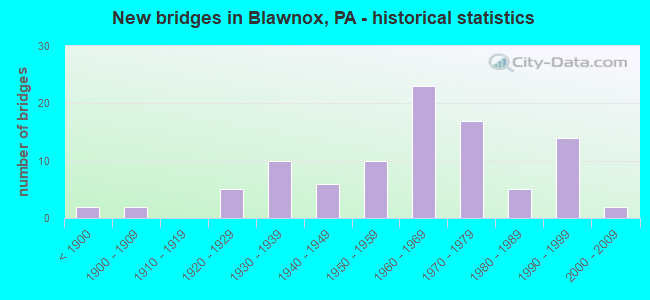
- New bridges - historical statistics
- 2Before 1900
- 21900-1909
- 51920-1929
- 101930-1939
- 61940-1949
- 101950-1959
- 231960-1969
- 171970-1979
- 51980-1989
- 141990-1999
- 22000-2009

- Reconstructed bridges - Historical Statistics
- 31940-1949
- 11950-1959
- 21960-1969
- 21970-1979
- 21980-1989
- 41990-1999
- 92000-2009
- 52010-2019


- Bridge Condition - Deck
- 16.7%Very good
- 28.6%Good
- 28.6%Satisfactory
- 25.0%Fair
- 1.2%Poor

- Bridge Condition - Superstructure
- 14.9%Very good
- 20.7%Good
- 33.3%Satisfactory
- 25.3%Fair
- 5.7%Poor

- Bridge Condition - Substructure
- 4.6%Very good
- 29.9%Good
- 26.4%Satisfactory
- 34.5%Fair
- 4.6%Poor

- Bridge Condition - Channel
- 5.8%Very good
- 15.9%Good
- 33.3%Satisfactory
- 34.8%Fair
- 10.1%Poor

- Bridge Condition - Culverts
- 20.0%Good
- 40.0%Satisfactory
- 30.0%Fair
- 10.0%Poor
Find on map >> Show street view
Structure Number: 15251, Location: 1MI.WEST MEDIA 34A05 (Lat: 39.916908, Lng: -75.404039), Route carried "on" structure: State highway , Year Built: 1947, Status: Open, Structure Length: 4.36m (14.30ft), Average Daily Traffic: 13,224 (year 2020), Truck Traffic: 6%, Average Future Daily Traffic: 20,658 (year 2032), Design Load: HS 20, Features Intersected: RIDLEY CREEK, Facility Carried by Structure: BALTIMORE PIKE
Minimum Vertical Clearance: 30+ m (98+ ft), Kilometerpoint: 1.521, Lanes on structure: 4, Base Highway Network: Yes, Owner: State Highway Agency, Approaching Roadway Width: 21.3m (69.9ft), Skew: 22 degrees, Material/Design: Concrete, Design/Construction: Frame, Number Of Spans In Main Unit: 2, Length of Maximum Span: 21.3m (69.9ft), Curb or Sidewalk Widths: Left: 1.5m (4.9ft), Right: 1.1m (3.6ft), Curb-To-Curb Width: 16.5m (54.1ft), Out-to-Out Width: 20.1m (65.9ft)
Condition: Deck: Satisfactory, Superstructure: Satisfactory, Substructure: Fair, Channel: Fair, Inventory Rating: 66.2 metric tons, Method Used To Determine Inventory Rating: Load Factor (LF), Structural Evaluation: Somewhat better than minimum adequacy, Deck Geometry: Meets minimum limits, Waterway Adequacy: Superior to present desirable criteria, Approach Roadway Alignment: Equal to present desirable criteria, Length Of Structure Improvement: 5.20m (17.06ft), Designated Inspection Frequency: Every 24 months, Underwater Inspection Frequency: Every 24 months, Inspection Date: Febuary 2020, Underwater Inspection Date: October 2020, Wearing Surface/Protective System: Wearing Surface: Bituminous
Find on map >> Show street view
Structure Number: 15312, Location: 1MI.S.KNOWLTON 42K01 (Lat: 39.870083, Lng: -75.408839), Route carried "on" structure: State highway , Year Built: 1920, Year Reconstructed: 2011, Status: Open, Structure Length: 0.91m (2.99ft), Average Daily Traffic: 1,190 (year 2022), Truck Traffic: 2%, Average Future Daily Traffic: 2,153 (year 2032), Design Load: HL 93, Features Intersected: BRANCH CHESTER CREEK, Facility Carried by Structure: CHESTER CREEK ROAD
Minimum Vertical Clearance: 30+ m (98+ ft), Kilometerpoint: 1.650, Lanes on structure: 2, Owner: State Highway Agency, Approaching Roadway Width: 6.1m (20.0ft), Material/Design: Prestressed concrete, Design/Construction: Box Beam or Girders - Single/Spread, Number Of Spans In Main Unit: 1, Length of Maximum Span: 7.9m (25.9ft), Curb-To-Curb Width: 6.1m (20.0ft), Out-to-Out Width: 7.0m (23.0ft)
Condition: Deck: Good, Superstructure: Very good, Substructure: Satisfactory, Channel: Satisfactory, Operating Rating: 67.4 metric tons, Method Used To Determine Operating Rating: Assigned ratings based on Load and Resistance Factor Design (LRFD) reported by rating factor (RF) using HL93 loadings, Inventory Rating: 42.4 metric tons, Method Used To Determine Inventory Rating: Assigned ratings based on Load and Resistance Factor Design (LRFD) reported by rating factor (RF) using HL93 loadings, Structural Evaluation: Equal to present minimum criteria, Deck Geometry: High priority of replacement, Waterway Adequacy: Better than present minimum criteria, Approach Roadway Alignment: Somewhat better than minimum adequacy, Length Of Structure Improvement: 1.40m (4.59ft), Designated Inspection Frequency: Every 24 months, Inspection Date: April 2021, Bridge Improvement Cost: $26,000, Roadway Improvement Cost: $77,000, Total Project Cost: $351,000, Deck Structure Type: Concrete Cast-file-Place, Wearing Surface/Protective System: Wearing Surface: Monolithic Concrete, Membrane: Other, Deck Protection: Epoxy Coated Reinforcing
Find on map >> Show street view
Structure Number: 15788, Location: SPRINGFIELD TOWNSHIP (Lat: 41.994244, Lng: -80.419864), Route carried "on" structure: State highway 5, Year Built: 1936, Status: Open, Structure Length: 0.79m (2.59ft), Average Daily Traffic: 2,564 (year 2022), Truck Traffic: 7%, Average Future Daily Traffic: 2,421 (year 2032), Design Load: H 20, Features Intersected: OVER CROOKED CREEK
Minimum Vertical Clearance: 30+ m (98+ ft), Kilometerpoint: 8.034, Lanes on structure: 2, Owner: State Highway Agency, Approaching Roadway Width: 9.8m (32.2ft), Material/Design: Concrete, Design/Construction: Arch - Deck, Number Of Spans In Main Unit: 1, Length of Maximum Span: 7.9m (25.9ft), Curb or Sidewalk Widths: Left: 0.1m (0.3ft), Right: 0.1m (0.3ft), Curb-To-Curb Width: 11.7m (38.4ft), Out-to-Out Width: 13.1m (43.0ft)
Condition: Superstructure: Fair, Substructure: Fair, Channel: Poor, Operating Rating: 77.1 metric tons, Method Used To Determine Operating Rating: Allowable Stress (AS), Inventory Rating: 46.3 metric tons, Method Used To Determine Inventory Rating: Allowable Stress (AS), Structural Evaluation: Somewhat better than minimum adequacy, Deck Geometry: Somewhat better than minimum adequacy, Waterway Adequacy: Superior to present desirable criteria, Approach Roadway Alignment: Equal to present desirable criteria, Length Of Structure Improvement: 0.80m (2.62ft), Designated Inspection Frequency: Every 24 months, Underwater Inspection Frequency: Every 5 months, Inspection Date: November 2021, Bridge Improvement Cost: $8,000, Roadway Improvement Cost: $24,000, Total Project Cost: $109,000, Deck Structure Type: Other
Find on map >> Show street view
Structure Number: 15963, Location: MCKEAN TOWNSHIP (Lat: 42.021122, Lng: -80.129256), Route carried "on" structure: State highway , Year Built: 1969, Status: Open, Structure Length: 7.80m (25.59ft), Average Daily Traffic: 1,535 (year 2020), Truck Traffic: 4%, Average Future Daily Traffic: 2,051 (year 2032), Design Load: HS 20, Features Intersected: OVER SR 79,NB/SB, Facility Carried by Structure: SR 4104,BARGAIN RD
Minimum Vertical Clearance: 30+ m (98+ ft), Kilometerpoint: 0.000, Lanes on structure: 2, Lanes under structure: 8, Owner: State Highway Agency, Approaching Roadway Width: 6.4m (21.0ft), Skew: 2 degrees, Material/Design: Prestressed concrete, Design/Construction: Box Beam or Girders - Single/Spread, Number Of Spans In Main Unit: 5, Length of Maximum Span: 19.8m (65.0ft), Curb or Sidewalk Widths: Left: 0.5m (1.6ft), Right: 0.5m (1.6ft), Curb-To-Curb Width: 8.5m (27.9ft), Out-to-Out Width: 10.2m (33.5ft)
Condition: Deck: Fair, Superstructure: Satisfactory, Substructure: Poor, Operating Rating: 88.0 metric tons, Method Used To Determine Operating Rating: Load Factor (LF), Inventory Rating: 35.4 metric tons, Method Used To Determine Inventory Rating: Load Factor (LF), Structural Evaluation: Meets minimum limits, Deck Geometry: Somewhat better than minimum adequacy, Underclear: Somewhat better than minimum adequacy, Approach Roadway Alignment: Equal to present desirable criteria, Length Of Structure Improvement: 7.80m (25.59ft), Designated Inspection Frequency: Every 24 months, Inspection Date: May 2020, Bridge Improvement Cost: $21,000, Roadway Improvement Cost: $63,000, Total Project Cost: $287,000, Deck Structure Type: Concrete Cast-file-Place, Wearing Surface/Protective System: Wearing Surface: Bituminous, Membrane: Preformed Fabric
Find on map >> Show street view
Structure Number: 16221, Location: NORTH EAST TOWNSHIP (Lat: 42.188625, Lng: -79.872883), Route carried "on" structure: State highway , Year Built: 1972, Status: Open, Structure Length: 1.13m (3.71ft), Average Daily Traffic: 231 (year 2022), Truck Traffic: 7%, Average Future Daily Traffic: 571 (year 2032), Design Load: HS 20, Features Intersected: OVER 12 MILE CREEK, Facility Carried by Structure: SR 1013,WILLIAMS R
Minimum Vertical Clearance: 30+ m (98+ ft), Kilometerpoint: 10.313, Lanes on structure: 2, Owner: State Highway Agency, Approaching Roadway Width: 5.2m (17.1ft), Skew: 2 degrees, Material/Design: Concrete, Design/Construction: Culvert, Number Of Spans In Main Unit: 2, Length of Maximum Span: 4.9m (16.1ft)
Condition: Channel: Fair, Culverts: Fair, Operating Rating: 49.0 metric tons, Method Used To Determine Operating Rating: Allowable Stress (AS), Inventory Rating: 32.7 metric tons, Method Used To Determine Inventory Rating: Allowable Stress (AS), Structural Evaluation: Somewhat better than minimum adequacy, Waterway Adequacy: Superior to present desirable criteria, Approach Roadway Alignment: Equal to present desirable criteria, Length Of Structure Improvement: 1.70m (5.58ft), Designated Inspection Frequency: Every 24 months, Inspection Date: March 2020
Find on map >> Show street view
Structure Number: 1727, Location: JENKS TOWNSHIP (Lat: 41.475778, Lng: -79.136611), Route carried "on" structure: City street 7206, Year Built: 1920, Year Reconstructed: 1984, Status: Open, Structure Length: 0.94m (3.08ft), Average Daily Traffic: 55 (year 2021), Truck Traffic: 3%, Average Future Daily Traffic: 70 (year 2041), Design Load: H 20, Features Intersected: OVER SALMON CREEK, Facility Carried by Structure: T-356
Minimum Vertical Clearance: 30+ m (98+ ft), Kilometerpoint: 0.000, Lanes on structure: 1, Owner: Town or Township Highway Agency, Approaching Roadway Width: 4.3m (14.1ft), Material/Design: Steel, Design/Construction: Stringer/Multi-beam, Number Of Spans In Main Unit: 1, Length of Maximum Span: 8.2m (26.9ft), Curb-To-Curb Width: 4.6m (15.1ft), Out-to-Out Width: 4.8m (15.7ft)
Condition: Deck: Satisfactory, Superstructure: Fair, Substructure: Fair, Channel: Satisfactory, Operating Rating: 89.8 metric tons, Method Used To Determine Operating Rating: Load Factor (LF), Inventory Rating: 53.5 metric tons, Method Used To Determine Inventory Rating: Load Factor (LF), Structural Evaluation: Somewhat better than minimum adequacy, Deck Geometry: Better than present minimum criteria, Waterway Adequacy: Better than present minimum criteria, Approach Roadway Alignment: Somewhat better than minimum adequacy, Length Of Structure Improvement: 0.90m (2.95ft), Designated Inspection Frequency: Every 24 months, Inspection Date: June 2021, Bridge Improvement Cost: $2,000, Roadway Improvement Cost: $7,000, Total Project Cost: $30,000, Deck Structure Type: Corrugated Steel, Wearing Surface/Protective System: Wearing Surface: Bituminous, Membrane: Preformed Fabric
Find on map >> Show street view
Structure Number: 1761, Location: 2 MI. S.E. OF MOWERSVILLE (Lat: 40.097164, Lng: -77.570172), Route carried "on" structure: State highway , Year Built: 1827, Status: Posted for load, Structure Length: 3.11m (10.20ft), Average Daily Traffic: 797 (year 2022), Truck Traffic: 4%, Average Future Daily Traffic: 1,002 (year 2032), Features Intersected: CONODOGUINET CREEK, Facility Carried by Structure: SR 4018
Minimum Vertical Clearance: 30+ m (98+ ft), Kilometerpoint: 0.058, Lanes on structure: 1, Owner: State Highway Agency, Approaching Roadway Width: 8.2m (26.9ft), Material/Design: Masonry, Design/Construction: Arch - Deck, Number Of Spans In Main Unit: 3, Length of Maximum Span: 9.4m (30.8ft), Curb-To-Curb Width: 5.0m (16.4ft), Out-to-Out Width: 6.3m (20.7ft)
Condition: Superstructure: Poor, Substructure: Fair, Channel: Satisfactory, Operating Rating: 10.9 metric tons, Method Used To Determine Operating Rating: Field evaluation and documented engineering judgment, Inventory Rating: 6.4 metric tons, Method Used To Determine Inventory Rating: Field evaluation and documented engineering judgment, Structural Evaluation: High priority of replacement, Deck Geometry: High priority of replacement, Waterway Adequacy: Better than present minimum criteria, Approach Roadway Alignment: Equal to present desirable criteria, Bridge Posting: Required (Relationship of Operating Rating to Maximum Legal Load: > 39.9% below), Length Of Structure Improvement: 3.90m (12.80ft), Designated Inspection Frequency: Every 24 months, Other Special Inspection Frequency: Every 12 months, Inspection Date: April 2021, Other Special Inspection Date: April 2021, Bridge Improvement Cost: $67,000, Roadway Improvement Cost: $197,000, Total Project Cost: $903,000
Find on map >> Show street view
Structure Number: 18288, Location: CUMBERLAND TOWNSHIP (Lat: 39.853664, Lng: -80.026581), Route carried "on" structure: State highway , Year Built: 1952, Status: Posted for load, Structure Length: 1.19m (3.90ft), Average Daily Traffic: 712 (year 2020), Truck Traffic: 12%, Average Future Daily Traffic: 955 (year 2042), Design Load: H 20, Features Intersected: SOUTH BRANCH MUDDY CREEK, Facility Carried by Structure: SR 2017
Minimum Vertical Clearance: 30+ m (98+ ft), Kilometerpoint: 0.810, Lanes on structure: 2, Owner: State Highway Agency, Approaching Roadway Width: 5.5m (18.0ft), Skew: 1 degrees, Material/Design: Steel, Design/Construction: Stringer/Multi-beam, Number Of Spans In Main Unit: 1, Length of Maximum Span: 11.0m (36.1ft), Curb or Sidewalk Widths: Left: 0.2m (0.7ft), Right: 0.2m (0.7ft), Curb-To-Curb Width: 7.1m (23.3ft), Out-to-Out Width: 8.3m (27.2ft)
Condition: Deck: Fair, Superstructure: Fair, Substructure: Poor, Channel: Fair, Operating Rating: 38.1 metric tons, Method Used To Determine Operating Rating: Load Factor (LF), Inventory Rating: 22.7 metric tons, Method Used To Determine Inventory Rating: Load Factor (LF), Structural Evaluation: Meets minimum limits, Deck Geometry: Meets minimum limits, Waterway Adequacy: Equal to present desirable criteria, Approach Roadway Alignment: Better than present minimum criteria, Bridge Posting: Required (Relationship of Operating Rating to Maximum Legal Load: 10.0 - 19.9% below), Length Of Structure Improvement: 1.80m (5.91ft), Designated Inspection Frequency: Every 24 months, Other Special Inspection Frequency: Every 12 months, Inspection Date: October 2020, Other Special Inspection Date: October 2021, Bridge Improvement Cost: $21,000, Roadway Improvement Cost: $61,000, Total Project Cost: $280,000, Deck Structure Type: Closed Grating, Wearing Surface/Protective System: Wearing Surface: Bituminous
Find on map >> Show street view
Structure Number: 18557, Location: SOUTH OF CUMMINS (Lat: 39.834706, Lng: -80.137292), Route carried "on" structure: Other road , Year Built: 1958, Year Reconstructed: 2018, Status: Open, Structure Length: 1.10m (3.61ft), Average Daily Traffic: 100 (year 2017), Truck Traffic: 5%, Average Future Daily Traffic: 120 (year 2037), Design Load: HL 93, Features Intersected: DYERS FORK, Facility Carried by Structure: TOWNSHIP ROAD 459
Minimum Vertical Clearance: 30+ m (98+ ft), Kilometerpoint: 0.000, Lanes on structure: 2, Owner: County Highway Agency, Approaching Roadway Width: 6.1m (20.0ft), Material/Design: Steel, Design/Construction: Stringer/Multi-beam, Number Of Spans In Main Unit: 1, Length of Maximum Span: 9.8m (32.2ft), Curb-To-Curb Width: 5.5m (18.0ft), Out-to-Out Width: 6.4m (21.0ft)
Condition: Deck: Very good, Superstructure: Very good, Substructure: Very good, Channel: Very good, Operating Rating: 62.5 metric tons, Method Used To Determine Operating Rating: Assigned ratings based on Load and Resistance Factor Design (LRFD) reported by rating factor (RF) using HL93 loadings, Inventory Rating: 48.3 metric tons, Method Used To Determine Inventory Rating: Assigned ratings based on Load and Resistance Factor Design (LRFD) reported by rating factor (RF) using HL93 loadings, Structural Evaluation: Equal to present desirable criteria, Deck Geometry: Meets minimum limits, Waterway Adequacy: Better than present minimum criteria, Approach Roadway Alignment: Equal to present desirable criteria, Length Of Structure Improvement: 1.60m (5.25ft), Designated Inspection Frequency: Every 24 months, Inspection Date: May 2020, Bridge Improvement Cost: $38,000, Roadway Improvement Cost: $223,000, Total Project Cost: $515,000, Deck Structure Type: Concrete Cast-file-Place, Wearing Surface/Protective System: Wearing Surface: Monolithic Concrete, Deck Protection: Epoxy Coated Reinforcing
Find on map >> Show street view
Structure Number: 19042, Location: GAIBLETON NO.1 (Lat: 40.722894, Lng: -79.106144), Route carried "on" structure: US 119, Year Built: 1924, Year Reconstructed: 1954, Status: Open, Structure Length: 2.16m (7.09ft), Average Daily Traffic: 6,695 (year 2020), Truck Traffic: 13%, Average Future Daily Traffic: 9,278 (year 2032), Design Load: HS 20, Features Intersected: CROOKED CREEK
Minimum Vertical Clearance: 30+ m (98+ ft), Kilometerpoint: 35.192, Lanes on structure: 2, Base Highway Network: Yes, Owner: State Highway Agency, Approaching Roadway Width: 10.4m (34.1ft), Skew: 1 degrees, Material/Design: Concrete, Design/Construction: Tee Beam, Number Of Spans In Main Unit: 2, Length of Maximum Span: 9.8m (32.2ft), Curb or Sidewalk Widths: Left: 0.2m (0.7ft), Right: 0.2m (0.7ft), Curb-To-Curb Width: 11.7m (38.4ft), Out-to-Out Width: 12.7m (41.7ft)
Condition: Deck: Fair, Superstructure: Poor, Substructure: Poor, Channel: Fair, Operating Rating: 48.1 metric tons, Method Used To Determine Operating Rating: Field evaluation and documented engineering judgment, Inventory Rating: 29.0 metric tons, Method Used To Determine Inventory Rating: Field evaluation and documented engineering judgment, Structural Evaluation: Meets minimum limits, Deck Geometry: Somewhat better than minimum adequacy, Waterway Adequacy: Equal to present minimum criteria, Approach Roadway Alignment: Somewhat better than minimum adequacy, Length Of Structure Improvement: 2.20m (7.22ft), Designated Inspection Frequency: Every 24 months, Inspection Date: May 2021, Bridge Improvement Cost: $34,000, Roadway Improvement Cost: $99,000, Total Project Cost: $454,000, Deck Structure Type: Concrete Cast-file-Place, Wearing Surface/Protective System: Wearing Surface: Bituminous
Find on map >> Show street view
Structure Number: 21061, Location: 1 MI NW OF QUARRYVILLE (Lat: 39.906906, Lng: -76.184194), Route carried "on" structure: US 222, Year Built: 1984, Status: Open, Structure Length: 1.25m (4.10ft), Average Daily Traffic: 9,933 (year 2020), Truck Traffic: 8%, Average Future Daily Traffic: 12,203 (year 2035), Design Load: HS 25 or greater, Features Intersected: BR. BEAVER CREEK
Minimum Vertical Clearance: 30+ m (98+ ft), Kilometerpoint: 24.621, Lanes on structure: 2, Owner: State Highway Agency, Approaching Roadway Width: 11.3m (37.1ft), Skew: 1 degrees, Material/Design: Prestressed concrete, Design/Construction: Box Beam or Girders - Multiple, Number Of Spans In Main Unit: 1, Length of Maximum Span: 12.2m (40.0ft), Curb or Sidewalk Widths: Left: 0.2m (0.7ft), Right: 0.2m (0.7ft), Curb-To-Curb Width: 11.2m (36.7ft), Out-to-Out Width: 12.3m (40.4ft)
Condition: Deck: Good, Superstructure: Satisfactory, Substructure: Good, Channel: Satisfactory, Inventory Rating: 60.8 metric tons, Method Used To Determine Inventory Rating: Load Factor (LF), Structural Evaluation: Equal to present minimum criteria, Deck Geometry: Meets minimum limits, Waterway Adequacy: Equal to present desirable criteria, Approach Roadway Alignment: Equal to present desirable criteria, Length Of Structure Improvement: 1.90m (6.23ft), Designated Inspection Frequency: Every 24 months, Inspection Date: March 2020, Deck Structure Type: Concrete Cast-file-Place, Wearing Surface/Protective System: Wearing Surface: Bituminous, Deck Protection: Epoxy Coated Reinforcing
Find on map >> Show street view
Structure Number: 21146, Location: .3 MI.N. OF SMITHVILLE (Lat: 39.929503, Lng: -76.252781), Route carried "on" structure: State highway 272, Year Built: 1970, Status: Open, Structure Length: 0.88m (2.89ft), Average Daily Traffic: 10,098 (year 2022), Truck Traffic: 11%, Average Future Daily Traffic: 10,093 (year 2032), Design Load: HS 20, Features Intersected: HUBER RUN
Minimum Vertical Clearance: 30+ m (98+ ft), Kilometerpoint: 28.611, Lanes on structure: 2, Base Highway Network: Yes, Owner: State Highway Agency, Approaching Roadway Width: 11.6m (38.1ft), Skew: 3 degrees, Material/Design: Concrete, Design/Construction: Culvert, Number Of Spans In Main Unit: 1, Length of Maximum Span: 8.8m (28.9ft)
Condition: Channel: Satisfactory, Culverts: Satisfactory, Operating Rating: 89.8 metric tons, Method Used To Determine Operating Rating: Load Factor (LF), Inventory Rating: 88.9 metric tons, Method Used To Determine Inventory Rating: Load Factor (LF), Structural Evaluation: Equal to present minimum criteria, Waterway Adequacy: Equal to present desirable criteria, Approach Roadway Alignment: Equal to present desirable criteria, Length Of Structure Improvement: 1.40m (4.59ft), Designated Inspection Frequency: Every 48 months, Inspection Date: November 2019
Find on map >> Show street view
Structure Number: 21147, Location: 1 mi.S. of Smithville (Lat: 39.942356, Lng: -76.258353), Route carried "on" structure: State highway 272, Year Built: 1948, Year Reconstructed: 1970, Status: Open, Structure Length: 10.82m (35.50ft), Average Daily Traffic: 20,055 (year 2022), Truck Traffic: 10%, Average Future Daily Traffic: 20,352 (year 2032), Design Load: HS 20, Features Intersected: Pequea Creek, Facility Carried by Structure: Lancaster Pike
Minimum Vertical Clearance: 30+ m (98+ ft), Kilometerpoint: 30.500, Lanes on structure: 4, Base Highway Network: Yes, Owner: State Highway Agency, Approaching Roadway Width: 26.2m (86.0ft), Skew: 31 degrees, Material/Design: Steel continuous, Design/Construction: Stringer/Multi-beam, Number Of Spans In Main Unit: 4, Length of Maximum Span: 29.6m (97.1ft), Curb or Sidewalk Widths: Left: 0.2m (0.7ft), Right: 0.2m (0.7ft), Curb-To-Curb Width: 26.2m (86.0ft), Out-to-Out Width: 28.0m (91.9ft)
Condition: Deck: Fair, Superstructure: Fair, Substructure: Satisfactory, Channel: Fair, Operating Rating: 70.8 metric tons, Method Used To Determine Operating Rating: Load Factor (LF), Inventory Rating: 42.6 metric tons, Method Used To Determine Inventory Rating: Load Factor (LF), Structural Evaluation: Somewhat better than minimum adequacy, Deck Geometry: Superior to present desirable criteria, Waterway Adequacy: Better than present minimum criteria, Approach Roadway Alignment: Equal to present desirable criteria, Length Of Structure Improvement: 11.80m (38.71ft), Designated Inspection Frequency: Every 24 months, Inspection Date: April 2020, Bridge Improvement Cost: $156,000, Roadway Improvement Cost: $458,000, Total Project Cost: $2,101,000, Deck Structure Type: Concrete Cast-file-Place, Wearing Surface/Protective System: Wearing Surface: Monolithic Concrete
Find on map >> Show street view
Structure Number: 21149, Location: S OF OREGON MANHEIM TP (Lat: 40.104556, Lng: -76.255194), Route carried "on" structure: State highway 272, Year Built: 1970, Status: Open, Structure Length: 1.40m (4.59ft), Average Daily Traffic: 11,646 (year 2022), Truck Traffic: 2%, Average Future Daily Traffic: 13,041 (year 2032), Design Load: HS 20, Features Intersected: SHIRKS RUN
Minimum Vertical Clearance: 30+ m (98+ ft), Kilometerpoint: 41.235, Lanes on structure: 3, Owner: State Highway Agency, Approaching Roadway Width: 18.3m (60.0ft), Material/Design: Prestressed concrete, Design/Construction: Box Beam or Girders - Single/Spread, Number Of Spans In Main Unit: 1, Length of Maximum Span: 13.4m (44.0ft), Curb or Sidewalk Widths: Left: 0.2m (0.7ft), Right: 0.2m (0.7ft), Curb-To-Curb Width: 18.3m (60.0ft), Out-to-Out Width: 19.5m (64.0ft)
Condition: Deck: Good, Superstructure: Good, Substructure: Satisfactory, Channel: Satisfactory, Operating Rating: 69.9 metric tons, Method Used To Determine Operating Rating: Load Factor (LF), Inventory Rating: 31.8 metric tons, Method Used To Determine Inventory Rating: Load Factor (LF), Structural Evaluation: Equal to present minimum criteria, Deck Geometry: Superior to present desirable criteria, Waterway Adequacy: Better than present minimum criteria, Approach Roadway Alignment: Equal to present desirable criteria, Length Of Structure Improvement: 2.00m (6.56ft), Designated Inspection Frequency: Every 24 months, Inspection Date: Febuary 2021, Bridge Improvement Cost: $9,000, Roadway Improvement Cost: $28,000, Total Project Cost: $126,000, Deck Structure Type: Concrete Cast-file-Place, Wearing Surface/Protective System: Wearing Surface: Latex Concrete
Find on map >> Show street view
Structure Number: 21151, Location: 1.5 MI.S.W.OF BROWNSTOWN (Lat: 40.118547, Lng: -76.238044), Route carried "on" structure: State highway 272, Year Built: 1992, Status: Open, Structure Length: 6.71m (22.01ft), Average Daily Traffic: 10,055 (year 2020), Truck Traffic: 6%, Average Future Daily Traffic: 16,627 (year 2032), Design Load: HS 25 or greater, Features Intersected: COCALICO CREEK
Minimum Vertical Clearance: 30+ m (98+ ft), Kilometerpoint: 44.302, Lanes on structure: 2, Owner: State Highway Agency, Approaching Roadway Width: 7.3m (24.0ft), Material/Design: Prestressed concrete, Design/Construction: Box Beam or Girders - Single/Spread, Number Of Spans In Main Unit: 3, Length of Maximum Span: 21.9m (71.9ft), Curb or Sidewalk Widths: Left: 0.2m (0.7ft), Right: 0.2m (0.7ft), Curb-To-Curb Width: 12.2m (40.0ft), Out-to-Out Width: 13.3m (43.6ft)
Condition: Deck: Good, Superstructure: Satisfactory, Substructure: Good, Channel: Good, Operating Rating: 94.3 metric tons, Method Used To Determine Operating Rating: Load Factor (LF), Inventory Rating: 45.4 metric tons, Method Used To Determine Inventory Rating: Load Factor (LF), Structural Evaluation: Equal to present minimum criteria, Deck Geometry: Somewhat better than minimum adequacy, Waterway Adequacy: Superior to present desirable criteria, Approach Roadway Alignment: Equal to present desirable criteria, Length Of Structure Improvement: 8.40m (27.56ft), Designated Inspection Frequency: Every 48 months, Inspection Date: March 2021, Bridge Improvement Cost: $181,000, Roadway Improvement Cost: $534,000, Total Project Cost: $2,448,000, Deck Structure Type: Concrete Cast-file-Place, Wearing Surface/Protective System: Wearing Surface: Monolithic Concrete, Deck Protection: Epoxy Coated Reinforcing
Find on map >> Show street view
Structure Number: 21225, Location: Lanc. & Pequea Twp. Line (Lat: 39.996903, Lng: -76.311158), Route carried "on" structure: State highway 324, Year Built: 1930, Status: Open, Structure Length: 9.45m (31.00ft), Average Daily Traffic: 3,981 (year 2022), Truck Traffic: 3%, Average Future Daily Traffic: 5,849 (year 2032), Features Intersected: Conestoga River
Minimum Vertical Clearance: 30+ m (98+ ft), Kilometerpoint: 17.506, Lanes on structure: 2, Owner: State Highway Agency, Approaching Roadway Width: 11.6m (38.1ft), Material/Design: Concrete, Design/Construction: Arch - Deck, Number Of Spans In Main Unit: 3, Length of Maximum Span: 29.9m (98.1ft), Curb or Sidewalk Widths: Left: 0.3m (1.0ft), Right: 0.3m (1.0ft), Curb-To-Curb Width: 9.1m (29.9ft), Out-to-Out Width: 10.9m (35.8ft)
Condition: Superstructure: Fair, Substructure: Fair, Channel: Fair, Operating Rating: 59.9 metric tons, Method Used To Determine Operating Rating: Field evaluation and documented engineering judgment, Inventory Rating: 35.4 metric tons, Method Used To Determine Inventory Rating: Field evaluation and documented engineering judgment, Structural Evaluation: Somewhat better than minimum adequacy, Deck Geometry: Meets minimum limits, Waterway Adequacy: Superior to present desirable criteria, Approach Roadway Alignment: Equal to present desirable criteria, Length Of Structure Improvement: 10.10m (33.14ft), Designated Inspection Frequency: Every 24 months, Inspection Date: July 2020, Bridge Improvement Cost: $163,000, Roadway Improvement Cost: $479,000, Total Project Cost: $2,195,000
Find on map >> Show street view
Structure Number: 21226, Location: South Lancaster (Lat: 40.021475, Lng: -76.305044), Route carried "on" structure: State highway 324, Year Built: 1940, Year Reconstructed: 1954, Status: Open, Structure Length: 2.44m (8.01ft), Average Daily Traffic: 3,981 (year 2022), Truck Traffic: 3%, Average Future Daily Traffic: 5,849 (year 2032), Features Intersected: Trib to Conestoga River
Minimum Vertical Clearance: 30+ m (98+ ft), Kilometerpoint: 20.538, Lanes on structure: 2, Owner: City or Municipal Highway Agency, Maintenance Responsibility: Local Agency, Approaching Roadway Width: 12.2m (40.0ft), Skew: 6 degrees, Material/Design: Concrete, Design/Construction: Slab, Number Of Spans In Main Unit: 1, Number Of Approach Spans: 2, Length of Maximum Span: 7.9m (25.9ft), Curb-To-Curb Width: 12.2m (40.0ft), Out-to-Out Width: 13.4m (44.0ft)
Condition: Deck: Fair, Superstructure: Fair, Substructure: Fair, Channel: Good, Culverts: Good, Operating Rating: 49.0 metric tons, Method Used To Determine Operating Rating: Field evaluation and documented engineering judgment, Inventory Rating: 32.7 metric tons, Method Used To Determine Inventory Rating: Field evaluation and documented engineering judgment, Structural Evaluation: Somewhat better than minimum adequacy, Deck Geometry: Equal to present minimum criteria, Waterway Adequacy: Superior to present desirable criteria, Approach Roadway Alignment: Equal to present desirable criteria, Length Of Structure Improvement: 1.40m (4.59ft), Designated Inspection Frequency: Every 24 months, Inspection Date: June 2020, Bridge Improvement Cost: $20,000, Roadway Improvement Cost: $58,000, Total Project Cost: $265,000, Deck Structure Type: Concrete Cast-file-Place, Wearing Surface/Protective System: Wearing Surface: Bituminous
Find on map >> Show street view
Structure Number: 21387, Location: 2 MI EAST OF US 322 (Lat: 40.155000, Lng: -76.101797), Route carried "on" structure: State highway , Year Built: 1991, Status: Open, Structure Length: 1.83m (6.00ft), Average Daily Traffic: 4,017 (year 2022), Truck Traffic: 14%, Average Future Daily Traffic: 4,850 (year 2032), Design Load: HS 25 or greater, Features Intersected: QUARRY HAUL RD, Facility Carried by Structure: MARTINDALE RD
Minimum Vertical Clearance: 30+ m (98+ ft), Kilometerpoint: 12.546, Lanes on structure: 2, Owner: Private, Approaching Roadway Width: 9.8m (32.2ft), Material/Design: Prestressed concrete, Design/Construction: Box Beam or Girders - Multiple, Number Of Spans In Main Unit: 1, Length of Maximum Span: 17.7m (58.1ft), Curb or Sidewalk Widths: Left: 0.2m (0.7ft), Right: 0.2m (0.7ft), Curb-To-Curb Width: 10.0m (32.8ft), Out-to-Out Width: 11.1m (36.4ft)
Condition: Deck: Fair, Superstructure: Fair, Substructure: Good, Inventory Rating: 48.1 metric tons, Method Used To Determine Inventory Rating: Load Factor (LF), Structural Evaluation: Somewhat better than minimum adequacy, Deck Geometry: Meets minimum limits, Approach Roadway Alignment: Equal to present desirable criteria, Length Of Structure Improvement: 2.50m (8.20ft), Designated Inspection Frequency: Every 24 months, Inspection Date: March 2020, Deck Structure Type: Other, Wearing Surface/Protective System: Wearing Surface: Bituminous, Membrane: Preformed Fabric
Find on map >> Show street view
Structure Number: 297, Location: 4 MI. W. NEWPORT (Lat: 40.448844, Lng: -77.201242), Route carried "on" structure: State highway , Year Built: 1961, Status: Open, Structure Length: 1.49m (4.89ft), Average Daily Traffic: 484 (year 2020), Truck Traffic: 16%, Average Future Daily Traffic: 658 (year 2032), Design Load: HS 20, Features Intersected: LITTLE BUFFALO CREEK, Facility Carried by Structure: LITTLE BUFFALO RD.
Minimum Vertical Clearance: 30+ m (98+ ft), Kilometerpoint: 13.081, Lanes on structure: 2, Owner: State Highway Agency, Approaching Roadway Width: 6.1m (20.0ft), Skew: 3 degrees, Material/Design: Steel, Design/Construction: Stringer/Multi-beam, Number Of Spans In Main Unit: 1, Length of Maximum Span: 14.0m (45.9ft), Curb or Sidewalk Widths: Left: 0.5m (1.6ft), Right: 0.5m (1.6ft), Curb-To-Curb Width: 9.2m (30.2ft), Out-to-Out Width: 10.9m (35.8ft)
Condition: Deck: Fair, Superstructure: Fair, Substructure: Fair, Channel: Good, Operating Rating: 56.2 metric tons, Method Used To Determine Operating Rating: Load Factor (LF), Inventory Rating: 33.6 metric tons, Method Used To Determine Inventory Rating: Load Factor (LF), Structural Evaluation: Somewhat better than minimum adequacy, Deck Geometry: Equal to present minimum criteria, Waterway Adequacy: Superior to present desirable criteria, Approach Roadway Alignment: Equal to present desirable criteria, Length Of Structure Improvement: 2.20m (7.22ft), Designated Inspection Frequency: Every 24 months, Inspection Date: Febuary 2021, Bridge Improvement Cost: $40,000, Roadway Improvement Cost: $117,000, Total Project Cost: $535,000, Deck Structure Type: Concrete Cast-file-Place, Wearing Surface/Protective System: Wearing Surface: Bituminous, Membrane: Preformed Fabric
Find on map >> Show street view
Structure Number: 3651, Location: COOK TOWNSHIP (Lat: 40.214175, Lng: -79.322272), Route carried "on" structure: State highway , Year Built: 1924, Year Reconstructed: 1953, Status: Open, Structure Length: 1.07m (3.51ft), Average Daily Traffic: 125 (year 2022), Truck Traffic: 11%, Average Future Daily Traffic: 330 (year 2032), Design Load: HS 20, Features Intersected: BRANCH OF FOURMILE RUN, Facility Carried by Structure: SR 2037
Minimum Vertical Clearance: 30+ m (98+ ft), Kilometerpoint: 1.315, Lanes on structure: 2, Owner: State Highway Agency, Approaching Roadway Width: 6.7m (22.0ft), Material/Design: Steel, Design/Construction: Stringer/Multi-beam, Number Of Spans In Main Unit: 1, Length of Maximum Span: 8.2m (26.9ft), Curb-To-Curb Width: 6.6m (21.7ft), Out-to-Out Width: 7.6m (24.9ft)
Condition: Deck: Satisfactory, Superstructure: Fair, Substructure: Fair, Channel: Poor, Operating Rating: 85.3 metric tons, Method Used To Determine Operating Rating: Load Factor (LF), Inventory Rating: 50.8 metric tons, Method Used To Determine Inventory Rating: Load Factor (LF), Structural Evaluation: Somewhat better than minimum adequacy, Deck Geometry: Meets minimum limits, Waterway Adequacy: Equal to present minimum criteria, Approach Roadway Alignment: Equal to present desirable criteria, Length Of Structure Improvement: 1.80m (5.91ft), Designated Inspection Frequency: Every 24 months, Inspection Date: January 2020, Bridge Improvement Cost: $37,000, Roadway Improvement Cost: $108,000, Total Project Cost: $495,000, Deck Structure Type: Concrete Cast-file-Place, Wearing Surface/Protective System: Wearing Surface: Monolithic Concrete