Bridge Statistics for Blackfoot, Idaho (ID)
Condition, Traffic, Stress, Structural Evaluation, Project Costs
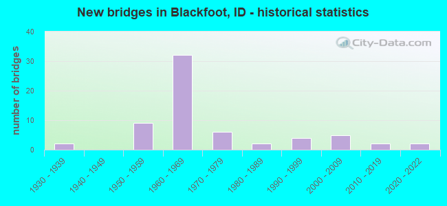
- New bridges - historical statistics
- 21930-1939
- 91950-1959
- 321960-1969
- 61970-1979
- 21980-1989
- 41990-1999
- 52000-2009
- 22010-2019
- 22020-2022
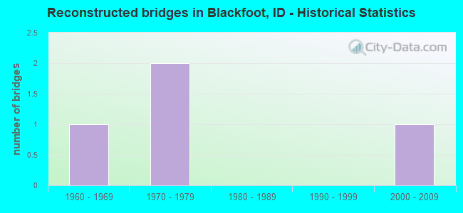
- Reconstructed bridges - Historical Statistics
- 11960-1969
- 21970-1979
- 01980-1989
- 01990-1999
- 12000-2009
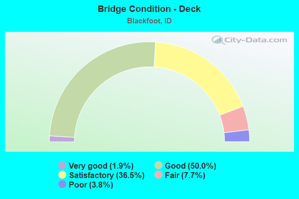
- Bridge Condition - Deck
- 1.9%Very good
- 50.0%Good
- 36.5%Satisfactory
- 7.7%Fair
- 3.8%Poor
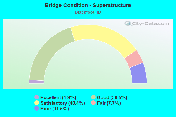
- Bridge Condition - Superstructure
- 1.9%Excellent
- 38.5%Good
- 40.4%Satisfactory
- 7.7%Fair
- 11.5%Poor
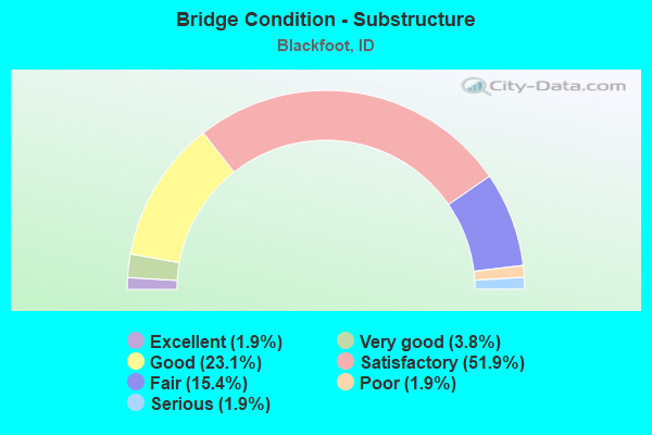
- Bridge Condition - Substructure
- 1.9%Excellent
- 3.8%Very good
- 23.1%Good
- 51.9%Satisfactory
- 15.4%Fair
- 1.9%Poor
- 1.9%Serious
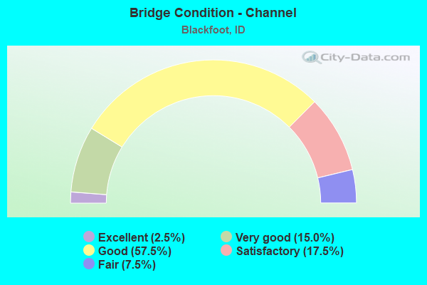
- Bridge Condition - Channel
- 2.5%Excellent
- 15.0%Very good
- 57.5%Good
- 17.5%Satisfactory
- 7.5%Fair
Find on map >> Show street view
Structure Number: 22415, Location: 2.8 S. 1.2 W. BLACKFOOT (Lat: 43.149167, Lng: -112.378139), Route carried "on" structure: County highway , Year Built: 1984, Status: Open, Structure Length: 0.94m (3.08ft), Average Daily Traffic: 150 (year 2019), Truck Traffic: 13%, Average Future Daily Traffic: 225 (year 2039), Design Load: HS 20, Features Intersected: NORTH CANAL, Facility Carried by Structure: SAMBO ROAD
Minimum Vertical Clearance: 30+ m (98+ ft), Kilometerpoint: 163.750, Lanes on structure: 2, Owner: County Highway Agency, Maintenance Responsibility: Bureau of Indian Affairs, Approaching Roadway Width: 6.1m (20.0ft), Skew: 3 degrees, Material/Design: Concrete, Design/Construction: Frame, Number Of Spans In Main Unit: 1, Length of Maximum Span: 9.4m (30.8ft), Curb-To-Curb Width: 9.8m (32.2ft), Out-to-Out Width: 10.4m (34.1ft)
Condition: Deck: Good, Superstructure: Good, Substructure: Good, Channel: Good, Operating Rating: 47.2 metric tons, Method Used To Determine Operating Rating: Field evaluation and documented engineering judgment, Inventory Rating: 28.1 metric tons, Method Used To Determine Inventory Rating: Field evaluation and documented engineering judgment, Structural Evaluation: Better than present minimum criteria, Deck Geometry: Better than present minimum criteria, Waterway Adequacy: Better than present minimum criteria, Approach Roadway Alignment: Equal to present desirable criteria, Designated Inspection Frequency: Every 24 months, Inspection Date: October 2020, Deck Structure Type: Concrete Cast-file-Place, Wearing Surface/Protective System: Wearing Surface: Bituminous
Find on map >> Show street view
Structure Number: 2246, Location: 0.6 S. 2.0 W. WAPELLO (Lat: 43.237806, Lng: -112.296389), Route carried "on" structure: County highway , Year Built: 1965, Status: Posted for load, Structure Length: 0.82m (2.69ft), Average Daily Traffic: 100 (year 2019), Truck Traffic: 5%, Average Future Daily Traffic: 150 (year 2039), Design Load: HS 15, Features Intersected: CORBETT SLOUGH CANAL, Facility Carried by Structure: COTTONWOOD ROAD
Minimum Vertical Clearance: 30+ m (98+ ft), Kilometerpoint: 162.254, Lanes on structure: 2, Owner: County Highway Agency, Approaching Roadway Width: 6.7m (22.0ft), Skew: 2 degrees, Material/Design: Prestressed concrete, Design/Construction: Tee Beam, Number Of Spans In Main Unit: 1, Length of Maximum Span: 7.9m (25.9ft), Curb or Sidewalk Widths: Left: 0.3m (1.0ft), Right: 0.3m (1.0ft), Curb-To-Curb Width: 7.9m (25.9ft), Out-to-Out Width: 8.5m (27.9ft)
Condition: Deck: Good, Superstructure: Good, Substructure: Good, Channel: Good, Operating Rating: 34.5 metric tons, Method Used To Determine Operating Rating: Field evaluation and documented engineering judgment, Inventory Rating: 20.9 metric tons, Method Used To Determine Inventory Rating: Field evaluation and documented engineering judgment, Structural Evaluation: Equal to present minimum criteria, Deck Geometry: Equal to present minimum criteria, Waterway Adequacy: Better than present minimum criteria, Approach Roadway Alignment: Somewhat better than minimum adequacy, Bridge Posting: Required (Relationship of Operating Rating to Maximum Legal Load: 10.0 - 19.9% below), Length Of Structure Improvement: 1.43m (4.69ft), Designated Inspection Frequency: Every 24 months, Inspection Date: April 2020, Bridge Improvement Cost: $217,000, Roadway Improvement Cost: $22,000, Total Project Cost: $326,000 ( Estimate for 2020), Deck Structure Type: Concrete Cast-file-Place, Wearing Surface/Protective System: Wearing Surface: Bituminous
Find on map >> Show street view
Structure Number: 22465, Location: 0.3 N. 1.0 W. WAPELLO (Lat: 43.250611, Lng: -112.277750), Route carried "on" structure: County highway , Year Built: 1965, Status: Open, Structure Length: 0.73m (2.40ft), Average Daily Traffic: 200 (year 2019), Truck Traffic: 5%, Average Future Daily Traffic: 300 (year 2039), Design Load: H 15, Features Intersected: CORBETT SLOUGH CANAL, Facility Carried by Structure: HANCOCK RD; 100 E
Minimum Vertical Clearance: 30+ m (98+ ft), Kilometerpoint: 162.476, Lanes on structure: 2, Owner: County Highway Agency, Approaching Roadway Width: 6.7m (22.0ft), Skew: 2 degrees, Material/Design: Prestressed concrete, Design/Construction: Tee Beam, Number Of Spans In Main Unit: 1, Length of Maximum Span: 7.0m (23.0ft), Curb or Sidewalk Widths: Left: 0.3m (1.0ft), Right: 0.3m (1.0ft), Curb-To-Curb Width: 7.9m (25.9ft), Out-to-Out Width: 8.5m (27.9ft)
Condition: Deck: Good, Superstructure: Good, Substructure: Good, Channel: Good, Operating Rating: 47.2 metric tons, Method Used To Determine Operating Rating: Field evaluation and documented engineering judgment, Inventory Rating: 28.1 metric tons, Method Used To Determine Inventory Rating: Field evaluation and documented engineering judgment, Structural Evaluation: Better than present minimum criteria, Deck Geometry: Somewhat better than minimum adequacy, Waterway Adequacy: Better than present minimum criteria, Approach Roadway Alignment: Equal to present minimum criteria, Designated Inspection Frequency: Every 24 months, Inspection Date: April 2020, Deck Structure Type: Concrete Cast-file-Place, Wearing Surface/Protective System: Wearing Surface: Bituminous
Find on map >> Show street view
Structure Number: 2257, Location: 2.7 S. 0.6 W. BLACKFOOT (Lat: 43.152556, Lng: -112.358361), Route carried "on" structure: County highway , Year Built: 1952, Year Reconstructed: 1982, Status: Open, Structure Length: 0.67m (2.20ft), Average Daily Traffic: 100 (year 2019), Truck Traffic: 10%, Average Future Daily Traffic: 150 (year 2039), Design Load: HS 20, Features Intersected: GIBSON CANAL, Facility Carried by Structure: SANDY ROAD
Minimum Vertical Clearance: 30+ m (98+ ft), Kilometerpoint: 162.532, Lanes on structure: 2, Owner: County Highway Agency, Approaching Roadway Width: 6.1m (20.0ft), Material/Design: Concrete, Design/Construction: Frame, Number Of Spans In Main Unit: 2, Length of Maximum Span: 3.0m (9.8ft), Curb or Sidewalk Widths: Left: 0.3m (1.0ft), Right: 0.3m (1.0ft), Curb-To-Curb Width: 7.6m (24.9ft), Out-to-Out Width: 8.2m (26.9ft)
Condition: Deck: Satisfactory, Superstructure: Satisfactory, Substructure: Fair, Channel: Satisfactory, Operating Rating: 56.2 metric tons, Method Used To Determine Operating Rating: Load Factor (LF), Inventory Rating: 33.6 metric tons, Method Used To Determine Inventory Rating: Load Factor (LF), Structural Evaluation: Somewhat better than minimum adequacy, Deck Geometry: Equal to present minimum criteria, Waterway Adequacy: Equal to present desirable criteria, Approach Roadway Alignment: Better than present minimum criteria, Length Of Structure Improvement: 5.49m (18.01ft), Designated Inspection Frequency: Every 24 months, Inspection Date: April 2020, Bridge Improvement Cost: $832,000, Roadway Improvement Cost: $83,000, Total Project Cost: $1,247,000 ( Estimate for 2020), Deck Structure Type: Concrete Cast-file-Place, Wearing Surface/Protective System: Wearing Surface: Bituminous
Find on map >> Show street view
Structure Number: 22865, Location: 5.6 N. 2.3 E. BLACKFOOT (Lat: 43.269778, Lng: -112.299417), Route carried "on" structure: County highway 1837, Year Built: 1981, Status: Open, Structure Length: 1.74m (5.71ft), Average Daily Traffic: 1,200 (year 2019), Truck Traffic: 11%, Average Future Daily Traffic: 1,800 (year 2039), Design Load: HS 20, Features Intersected: ABERDEEN SPRINGFIELD CNL
Minimum Vertical Clearance: 30+ m (98+ ft), Kilometerpoint: 9.109, Lanes on structure: 2, Owner: County Highway Agency, Approaching Roadway Width: 7.3m (24.0ft), Material/Design: Prestressed concrete, Design/Construction: Tee Beam, Number Of Spans In Main Unit: 1, Length of Maximum Span: 17.1m (56.1ft), Curb or Sidewalk Widths: Left: 0.3m (1.0ft), Right: 0.3m (1.0ft), Curb-To-Curb Width: 7.3m (24.0ft), Out-to-Out Width: 7.9m (25.9ft)
Condition: Deck: Good, Superstructure: Satisfactory, Substructure: Fair, Channel: Very good, Operating Rating: 34.5 metric tons, Method Used To Determine Operating Rating: Field evaluation and documented engineering judgment, Inventory Rating: 20.9 metric tons, Method Used To Determine Inventory Rating: Field evaluation and documented engineering judgment, Structural Evaluation: Somewhat better than minimum adequacy, Deck Geometry: Meets minimum limits, Waterway Adequacy: Equal to present desirable criteria, Approach Roadway Alignment: Equal to present minimum criteria, Length Of Structure Improvement: 2.44m (8.01ft), Designated Inspection Frequency: Every 24 months, Inspection Date: October 2021, Bridge Improvement Cost: $555,000, Roadway Improvement Cost: $56,000, Total Project Cost: $833,000 ( Estimate for 2019), Deck Structure Type: Concrete Cast-file-Place, Wearing Surface/Protective System: Wearing Surface: Bituminous
Find on map >> Show street view
Structure Number: 22875, Location: 5.6 N. 2.3 E. BLACKFOOT (Lat: 43.270000, Lng: -112.299400), Route carried "on" structure: County highway 1837, Year Built: 1954, Status: Open, Structure Length: 1.89m (6.20ft), Average Daily Traffic: 1,200 (year 2019), Truck Traffic: 11%, Average Future Daily Traffic: 1,800 (year 2039), Design Load: H 15, Features Intersected: PEOPLES CANAL
Minimum Vertical Clearance: 30+ m (98+ ft), Kilometerpoint: 9.143, Lanes on structure: 2, Owner: County Highway Agency, Approaching Roadway Width: 5.5m (18.0ft), Material/Design: Concrete, Design/Construction: Tee Beam, Number Of Spans In Main Unit: 2, Length of Maximum Span: 9.1m (29.9ft), Curb or Sidewalk Widths: Left: 0.3m (1.0ft), Right: 0.3m (1.0ft), Curb-To-Curb Width: 7.3m (24.0ft), Out-to-Out Width: 8.1m (26.6ft)
Condition: Deck: Satisfactory, Superstructure: Satisfactory, Substructure: Satisfactory, Channel: Good, Operating Rating: 50.8 metric tons, Method Used To Determine Operating Rating: Load Factor (LF), Inventory Rating: 30.8 metric tons, Method Used To Determine Inventory Rating: Load Factor (LF), Structural Evaluation: Equal to present minimum criteria, Deck Geometry: Meets minimum limits, Waterway Adequacy: Better than present minimum criteria, Approach Roadway Alignment: Equal to present minimum criteria, Length Of Structure Improvement: 2.62m (8.60ft), Designated Inspection Frequency: Every 24 months, Inspection Date: April 2020, Bridge Improvement Cost: $596,000, Roadway Improvement Cost: $60,000, Total Project Cost: $894,000 ( Estimate for 2020), Deck Structure Type: Concrete Cast-file-Place, Wearing Surface/Protective System: Wearing Surface: Bituminous
Find on map >> Show street view
Structure Number: 231, Location: 5.5 S. BLACKFOOT (Lat: 43.123667, Lng: -112.389250), Route carried "on" structure: County highway , Year Built: 1959, Status: Open, Structure Length: 8.60m (28.22ft), Average Daily Traffic: 250 (year 2019), Truck Traffic: 10%, Average Future Daily Traffic: 375 (year 2039), Design Load: HS 20, Features Intersected: I 15;FERRY BUTTE ROAD GS, Facility Carried by Structure: FERRY BUTTE RD
Minimum Vertical Clearance: 30+ m (98+ ft), Kilometerpoint: 10.445, Lanes on structure: 2, Lanes under structure: 4, Owner: State Highway Agency, Approaching Roadway Width: 7.3m (24.0ft), Material/Design: Prestressed concrete, Design/Construction: Stringer/Multi-beam, Number Of Spans In Main Unit: 5, Number Of Approach Spans: 1, Length of Maximum Span: 14.9m (48.9ft), Curb or Sidewalk Widths: Left: 0.4m (1.3ft), Right: 0.4m (1.3ft), Curb-To-Curb Width: 7.3m (24.0ft), Out-to-Out Width: 8.7m (28.5ft)
Condition: Deck: Good, Superstructure: Poor, Substructure: Satisfactory, Operating Rating: 50.8 metric tons, Method Used To Determine Operating Rating: Load Factor (LF), Inventory Rating: 30.8 metric tons, Method Used To Determine Inventory Rating: Load Factor (LF), Structural Evaluation: Meets minimum limits, Deck Geometry: Somewhat better than minimum adequacy, Underclear: Meets minimum limits, Approach Roadway Alignment: Equal to present desirable criteria, Length Of Structure Improvement: 9.45m (31.00ft), Designated Inspection Frequency: Every 12 months, Inspection Date: June 2021, Bridge Improvement Cost: $1,535,000, Roadway Improvement Cost: $154,000, Total Project Cost: $2,303,000 ( Estimate for 2018), Deck Structure Type: Concrete Cast-file-Place, Wearing Surface/Protective System: Wearing Surface: Monolithic Concrete
Find on map >> Show street view
Structure Number: 23105, Location: 4.5 S. BLACKFOOT (Lat: 43.138333, Lng: -112.389056), Route carried "on" structure: County highway , Year Built: 1959, Status: Open, Structure Length: 6.46m (21.19ft), Average Daily Traffic: 150 (year 2019), Truck Traffic: 13%, Average Future Daily Traffic: 225 (year 2039), Design Load: HS 20, Features Intersected: I 15;WILLIE ROAD GS, Facility Carried by Structure: WILLIE RD
Minimum Vertical Clearance: 30+ m (98+ ft), Kilometerpoint: 161.652, Lanes on structure: 2, Lanes under structure: 4, Owner: State Highway Agency, Approaching Roadway Width: 7.9m (25.9ft), Material/Design: Prestressed concrete, Design/Construction: Stringer/Multi-beam, Number Of Spans In Main Unit: 3, Number Of Approach Spans: 2, Length of Maximum Span: 14.9m (48.9ft), Curb or Sidewalk Widths: Left: 0.4m (1.3ft), Right: 0.4m (1.3ft), Curb-To-Curb Width: 7.3m (24.0ft), Out-to-Out Width: 8.7m (28.5ft)
Condition: Deck: Good, Superstructure: Poor, Substructure: Satisfactory, Operating Rating: 50.8 metric tons, Method Used To Determine Operating Rating: Load Factor (LF), Inventory Rating: 30.8 metric tons, Method Used To Determine Inventory Rating: Load Factor (LF), Structural Evaluation: Meets minimum limits, Deck Geometry: Somewhat better than minimum adequacy, Underclear: High priority of replacement, Approach Roadway Alignment: Better than present minimum criteria, Length Of Structure Improvement: 7.44m (24.41ft), Designated Inspection Frequency: Every 12 months, Inspection Date: June 2021, Bridge Improvement Cost: $1,127,000, Roadway Improvement Cost: $113,000, Total Project Cost: $1,691,000 ( Estimate for 2018), Deck Structure Type: Concrete Cast-file-Place, Wearing Surface/Protective System: Wearing Surface: Monolithic Concrete
Find on map >> Show street view
Structure Number: 23117, Location: 2.3 W. BLACKFOOT (Lat: 43.203806, Lng: -112.379278), Route carried "on" structure: City street 7611, Year Built: 1950, Status: Open, Structure Length: 1.22m (4.00ft), Average Daily Traffic: 2,500 (year 2019), Average Future Daily Traffic: 3,750 (year 2039), Design Load: HS 20, Features Intersected: TREGO DITCH
Minimum Vertical Clearance: 30+ m (98+ ft), Kilometerpoint: 0.050, Lanes on structure: 2, Owner: County Highway Agency, Approaching Roadway Width: 8.9m (29.2ft), Skew: 3 degrees, Material/Design: Concrete, Design/Construction: Tee Beam, Number Of Spans In Main Unit: 1, Length of Maximum Span: 11.3m (37.1ft), Curb or Sidewalk Widths: Left: 0.3m (1.0ft), Right: 0.3m (1.0ft), Curb-To-Curb Width: 9.2m (30.2ft), Out-to-Out Width: 10.0m (32.8ft)
Condition: Deck: Satisfactory, Superstructure: Satisfactory, Substructure: Satisfactory, Channel: Good, Operating Rating: 34.5 metric tons, Method Used To Determine Operating Rating: Field evaluation and documented engineering judgment, Inventory Rating: 20.9 metric tons, Method Used To Determine Inventory Rating: Field evaluation and documented engineering judgment, Structural Evaluation: Somewhat better than minimum adequacy, Deck Geometry: Meets minimum limits, Waterway Adequacy: Better than present minimum criteria, Approach Roadway Alignment: Better than present minimum criteria, Length Of Structure Improvement: 1.83m (6.00ft), Designated Inspection Frequency: Every 24 months, Inspection Date: March 2020, Bridge Improvement Cost: $436,000, Roadway Improvement Cost: $44,000, Total Project Cost: $653,000 ( Estimate for 2020), Deck Structure Type: Concrete Cast-file-Place, Wearing Surface/Protective System: Wearing Surface: Bituminous
Find on map >> Show street view
Structure Number: 2312, Location: IN BLACKFOOT;W.BRIDGE ST. (Lat: 43.198222, Lng: -112.370583), Route carried "on" structure: City street 7611, Year Built: 1936, Year Reconstructed: 2011, Status: Open, Structure Length: 14.72m (48.29ft), Average Daily Traffic: 6,400 (year 2019), Average Future Daily Traffic: 9,600 (year 2039), Design Load: H 15, Features Intersected: SNAKE RIVER
Minimum Vertical Clearance: 4.50m (14.76ft), Kilometerpoint: 0.991, Lanes on structure: 2, Owner: City or Municipal Highway Agency, Approaching Roadway Width: 7.3m (24.0ft), Material/Design: Steel, Design/Construction: Truss - Thru, Number Of Spans In Main Unit: 2, Number Of Approach Spans: 2, Length of Maximum Span: 64.0m (210.0ft), Curb or Sidewalk Widths: Left: 0.0m, Right: 1.4m (4.6ft), Curb-To-Curb Width: 7.3m (24.0ft), Out-to-Out Width: 10.1m (33.1ft)
Condition: Deck: Satisfactory, Superstructure: Fair, Substructure: Serious, Channel: Good, Operating Rating: 46.3 metric tons, Method Used To Determine Operating Rating: Load Factor (LF), Inventory Rating: 28.1 metric tons, Method Used To Determine Inventory Rating: Load Factor (LF), Structural Evaluation: High priority of corrective action, Deck Geometry: High priority of replacement, Waterway Adequacy: Equal to present desirable criteria, Approach Roadway Alignment: Better than present minimum criteria, Length Of Structure Improvement: 15.91m (52.20ft), Designated Inspection Frequency: Every 12 months, Critical Feature Inspection Frequency: Every 24 months, Underwater Inspection Frequency: Every 60 months, Inspection Date: April 2021, Critical Feature Inspection Date: April 2021, Underwater Inspection Date: October 2020, Bridge Improvement Cost: $12,500,000, Roadway Improvement Cost: $500,000, Total Project Cost: $18,750,000 ( Estimate for 2016), Deck Structure Type: Concrete Cast-file-Place
Find on map >> Show street view
Structure Number: 23125, Location: 2.2 N. BLACKFOOT (Lat: 43.225433, Lng: -112.340906), Route carried "on" structure: County highway , Year Built: 1962, Status: Open, Structure Length: 7.74m (25.39ft), Average Daily Traffic: 1,300 (year 2019), Truck Traffic: 23%, Average Future Daily Traffic: 1,950 (year 2039), Design Load: HS 20, Features Intersected: I 15;W.PORTERVILLE RD.GS, Facility Carried by Structure: COUNTY ROAD
Minimum Vertical Clearance: 30+ m (98+ ft), Kilometerpoint: 26.910, Lanes on structure: 2, Lanes under structure: 4, Owner: State Highway Agency, Approaching Roadway Width: 7.3m (24.0ft), Skew: 3 degrees, Material/Design: Prestressed concrete, Design/Construction: Stringer/Multi-beam, Number Of Spans In Main Unit: 3, Number Of Approach Spans: 2, Length of Maximum Span: 17.7m (58.1ft), Curb or Sidewalk Widths: Left: 0.4m (1.3ft), Right: 0.4m (1.3ft), Curb-To-Curb Width: 7.3m (24.0ft), Out-to-Out Width: 8.7m (28.5ft)
Condition: Deck: Satisfactory, Superstructure: Good, Substructure: Satisfactory, Operating Rating: 77.1 metric tons, Method Used To Determine Operating Rating: Load Factor (LF), Inventory Rating: 46.3 metric tons, Method Used To Determine Inventory Rating: Load Factor (LF), Structural Evaluation: Equal to present minimum criteria, Deck Geometry: Meets minimum limits, Underclear: High priority of replacement, Approach Roadway Alignment: Equal to present desirable criteria, Length Of Structure Improvement: 8.90m (29.20ft), Designated Inspection Frequency: Every 48 months, Inspection Date: August 2021, Bridge Improvement Cost: $1,927,000, Roadway Improvement Cost: $193,000, Total Project Cost: $2,891,000 ( Estimate for 2017), Deck Structure Type: Concrete Cast-file-Place, Wearing Surface/Protective System: Wearing Surface: Monolithic Concrete
Find on map >> Show street view
Structure Number: 23131, Location: 5.2 N. BLACKFOOT (Lat: 43.261778, Lng: -112.309583), Route carried "on" structure: County highway , Year Built: 2020, Status: Open, Structure Length: 7.22m (23.69ft), Average Daily Traffic: 1,200 (year 2019), Truck Traffic: 11%, Average Future Daily Traffic: 1,800 (year 2039), Design Load: HL 93, Features Intersected: I 15; ROSE ROAD IC, Facility Carried by Structure: ROSE ROAD
Minimum Vertical Clearance: 30+ m (98+ ft), Kilometerpoint: 7.660, Lanes on structure: 2, Lanes under structure: 4, Owner: State Highway Agency, Approaching Roadway Width: 17.4m (57.1ft), Skew: 3 degrees, Material/Design: Prestressed concrete, Design/Construction: Tee Beam, Number Of Spans In Main Unit: 2, Length of Maximum Span: 35.4m (116.1ft), Curb-To-Curb Width: 17.5m (57.4ft), Out-to-Out Width: 18.3m (60.0ft)
Condition: Deck: Very good, Superstructure: Excellent, Substructure: Excellent, Operating Rating: 52.8 metric tons, Method Used To Determine Operating Rating: Load and Resistance Factor Rating (LRFR) rating reported by rating factor(RF) method using HL-93 loadings, Inventory Rating: 40.8 metric tons, Method Used To Determine Inventory Rating: Load and Resistance Factor Rating (LRFR) rating reported by rating factor(RF) method using HL-93 loadings, Structural Evaluation: Superior to present desirable criteria, Deck Geometry: Superior to present desirable criteria, Underclear: Better than present minimum criteria, Approach Roadway Alignment: Equal to present desirable criteria, Designated Inspection Frequency: Every 24 months, Inspection Date: June 2020, Deck Structure Type: Concrete Precast Panels, Wearing Surface/Protective System: Wearing Surface: Bituminous, Membrane: Other, Deck Protection: Epoxy Coated Reinforcing
Find on map >> Show street view
Structure Number: 1144, Location: 3.8 S. BLACKFOOT (Lat: 43.149250, Lng: -112.388861), Route carried "under" structure: Business Interstate 15, Year Built: 1961, Structure Length: 0. m, Average Daily Traffic: 5,800 (year 2018), Truck Traffic: 6%, Features Intersected: I15B;UPRR;S.BLACKFOOT IC
Minimum Vertical Clearance: 7.64m (25.07ft), Kilometerpoint: 0.137, Lanes on structure: 2, Lanes under structure: 2, Material/Design: Prestressed concrete, Design/Construction: Stringer/Multi-beam, Length of Maximum Span: 23.8m (78.1ft)
Find on map >> Show street view
Structure Number: 11445, Location: 3.8 S. BLACKFOOT (Lat: 43.148500, Lng: -112.388500), Route carried "under" structure: Business Interstate 15, Year Built: 1961, Structure Length: 0. m, Average Daily Traffic: 5,800 (year 2018), Truck Traffic: 6%, Features Intersected: I15B;UPRR;S.BLACKFOOT IC
Minimum Vertical Clearance: 7.62m (25.00ft), Kilometerpoint: 0.185, Lanes on structure: 2, Lanes under structure: 2, Material/Design: Prestressed concrete, Design/Construction: Stringer/Multi-beam, Length of Maximum Span: 23.8m (78.1ft)
Find on map >> Show street view
Structure Number: 11465, Location: 0.3 S. BLACKFOOT (Lat: 43.194722, Lng: -112.367056), Route carried "under" structure: City street 7611, Year Built: 1962, Structure Length: 0. m, Average Daily Traffic: 5,300 (year 2018), Features Intersected: W.BRIDGE ST.GS;UPRR OP, Facility Carried by Structure: I 15 NBL
Minimum Vertical Clearance: 8.41m (27.59ft), Kilometerpoint: 1.429, Lanes on structure: 2, Lanes under structure: 2, Material/Design: Prestressed concrete, Design/Construction: Stringer/Multi-beam, Length of Maximum Span: 15.5m (50.9ft)
Find on map >> Show street view
Structure Number: 1147, Location: 0.3 S. BLACKFOOT (Lat: 43.195583, Lng: -112.366722), Route carried "under" structure: City street 7611, Year Built: 1962, Structure Length: 0. m, Average Daily Traffic: 5,300 (year 2018), Features Intersected: W.BRIDGE ST.GS;UPRR OP, Facility Carried by Structure: I 15 SBL
Minimum Vertical Clearance: 8.13m (26.67ft), Kilometerpoint: 1.463, Lanes on structure: 2, Lanes under structure: 2, Material/Design: Prestressed concrete, Design/Construction: Stringer/Multi-beam, Length of Maximum Span: 16.8m (55.1ft)
Find on map >> Show street view
Structure Number: 11475, Location: AT BLACKFOOT (Lat: 43.198472, Lng: -112.363778), Route carried "under" structure: US 26, Year Built: 1962, Structure Length: 0. m, Average Daily Traffic: 20,000 (year 2018), Truck Traffic: 2%, Features Intersected: US 26;WEST BLACKFOOT IC, Facility Carried by Structure: I 15 NBL
Minimum Vertical Clearance: 5.33m (17.49ft), Kilometerpoint: 492.482, Lanes on structure: 2, Lanes under structure: 5, Material/Design: Concrete, Design/Construction: Stringer/Multi-beam, Length of Maximum Span: 14.6m (47.9ft)
Find on map >> Show street view
Structure Number: 1148, Location: AT BLACKFOOT (Lat: 43.198972, Lng: -112.363806), Route carried "under" structure: US 26, Year Built: 1962, Structure Length: 0. m, Average Daily Traffic: 20,000 (year 2018), Truck Traffic: 2%, Features Intersected: US 26;WEST BLACKFOOT IC, Facility Carried by Structure: I 15 SBL
Minimum Vertical Clearance: 4.88m (16.01ft), Kilometerpoint: 492.466, Lanes on structure: 2, Lanes under structure: 5, Toll: Toll bridge, Material/Design: Concrete, Design/Construction: Stringer/Multi-beam, Length of Maximum Span: 14.6m (47.9ft)
Find on map >> Show street view
Structure Number: 19226, Location: 3.6 N. BLACKFOOT (Lat: 43.242833, Lng: -112.325667), Route carried "under" structure: Interstate 15, Year Built: 2000, Structure Length: 0. m, Average Daily Traffic: 24,500 (year 2018), Truck Traffic: 17%, Features Intersected: I 15 SB-NB;ROSE ROAD GS, Facility Carried by Structure: STC 1833;ROSE ROAD
Minimum Vertical Clearance: 5.28m (17.32ft), Kilometerpoint: 154.669, Lanes on structure: 2, Lanes under structure: 4, Material/Design: Prestressed concrete continuous, Design/Construction: Stringer/Multi-beam, Length of Maximum Span: 32.9m (107.9ft)
Find on map >> Show street view
Structure Number: 2172, Location: 1.3 S. BLACKFOOT (Lat: 43.182167, Lng: -112.378742), Route carried "under" structure: Interstate 15, Year Built: 1962, Structure Length: 0. m, Average Daily Traffic: 25,500 (year 2018), Truck Traffic: 16%, Features Intersected: I 15;RIVERTON ROAD GS, Facility Carried by Structure: SMA 7721;RIVERTON
Minimum Vertical Clearance: 5.05m (16.57ft), Kilometerpoint: 146.727, Lanes on structure: 2, Lanes under structure: 4, Material/Design: Prestressed concrete, Design/Construction: Stringer/Multi-beam, Length of Maximum Span: 15.2m (49.9ft)
Find on map >> Show street view
Structure Number: 231, Location: 5.5 S. BLACKFOOT (Lat: 43.123667, Lng: -112.389250), Route carried "under" structure: Interstate 15, Year Built: 1959, Structure Length: 0. m, Average Daily Traffic: 26,000 (year 2018), Truck Traffic: 16%, Features Intersected: I 15;FERRY BUTTE ROAD GS, Facility Carried by Structure: FERRY BUTTE RD
Minimum Vertical Clearance: 4.93m (16.17ft), Kilometerpoint: 140.031, Lanes on structure: 2, Lanes under structure: 4, Material/Design: Prestressed concrete, Design/Construction: Stringer/Multi-beam, Length of Maximum Span: 14.9m (48.9ft)
Find on map >> Show street view
Structure Number: 23105, Location: 4.5 S. BLACKFOOT (Lat: 43.138333, Lng: -112.389056), Route carried "under" structure: Interstate 15, Year Built: 1959, Structure Length: 0. m, Average Daily Traffic: 26,000 (year 2018), Truck Traffic: 16%, Features Intersected: I 15;WILLIE ROAD GS, Facility Carried by Structure: WILLIE RD
Minimum Vertical Clearance: 5.31m (17.42ft), Kilometerpoint: 141.663, Lanes on structure: 2, Lanes under structure: 4, Material/Design: Prestressed concrete, Design/Construction: Stringer/Multi-beam, Length of Maximum Span: 14.9m (48.9ft)
Find on map >> Show street view
Structure Number: 23125, Location: 2.2 N. BLACKFOOT (Lat: 43.225433, Lng: -112.340906), Route carried "under" structure: Interstate 15, Year Built: 1962, Structure Length: 0. m, Average Daily Traffic: 24,500 (year 2018), Truck Traffic: 17%, Features Intersected: I 15;W.PORTERVILLE RD.GS, Facility Carried by Structure: COUNTY ROAD
Minimum Vertical Clearance: 5.00m (16.40ft), Kilometerpoint: 152.440, Lanes on structure: 2, Lanes under structure: 4, Material/Design: Prestressed concrete, Design/Construction: Stringer/Multi-beam, Length of Maximum Span: 17.7m (58.1ft)
Find on map >> Show street view
Structure Number: 23131, Location: 5.2 N. BLACKFOOT (Lat: 43.261778, Lng: -112.309583), Route carried "under" structure: Interstate 15, Year Built: 2020, Structure Length: 0. m, Average Daily Traffic: 26,000 (year 2020), Truck Traffic: 16%, Features Intersected: I 15; ROSE ROAD IC, Facility Carried by Structure: ROSE ROAD
Minimum Vertical Clearance: 5.31m (17.42ft), Kilometerpoint: 157.025, Lanes on structure: 2, Lanes under structure: 4, Material/Design: Prestressed concrete, Design/Construction: Tee Beam, Length of Maximum Span: 35.4m (116.1ft)